National parkŞanlıurfa

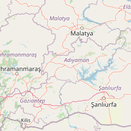
Tek Tek Mountains National Park: Protected Area with Ancient Ruins in Şanlıurfa, Turkey
Mapped geography and historical landscapes within Turkey's southeastern steppe.
Tek Tek Mountains National Park represents a vital protected area in Şanlıurfa Province, southeastern Turkey. This national park safeguards a unique landscape defined by the Tek Tek mountain range, featuring rugged terrain, rocky outcrops, and semi-arid steppe ecosystems. Beyond its natural beauty, the park is renowned for its significant archaeological heritage, including ancient settlements and religious sites that offer a glimpse into the region's historical depth. MoriAtlas provides a structured atlas view of this protected landscape, detailing its geographic features and its place within the regional context.
- Area
- 193.35 km²
- Established
- 2007
- IUCN
- II
- Relief
- Mixed relief