Mori Atlas logo
National parkAltındere Valley National Park

Explore the dramatic cliff-side monastery and rugged terrain within Turkey's Black Sea Region.

Altındere Valley National Park: Iconic Protected Landscape and Geographic Marvel in Trabzon Province

(Altındere Vadisi Milli Parkı)

Altındere Valley National Park stands as a remarkable protected area in Turkey's Trabzon Province, celebrated for its extraordinary natural beauty and profound cultural heritage. This national park, established to preserve the unique environment of the Altındere valley, features approximately 4,500 hectares of dramatic mountainous terrain characterized by steep gorges and densely forested slopes. Its iconic geography is defined by the Altındere River carving through the Pontic Mountains, creating a landscape where the historic Sümela Monastery appears to cling impossibly to a sheer cliff face 270 meters above the valley floor. The park offers a unique opportunity for atlas-driven discovery of a landscape where natural wonders and ancient human achievement converge.

National ParksCliff-side MonasteriesBlack Sea RegionPontic MountainsByzantine HeritageForest Protected Areas

Altındere Valley National Park

National park

Park overview

Structured park overview, official facts, and landscape profile for Altındere Valley National Park

Altındere Valley National Park park facts, protected area profile, and essential visitor context
Review the core facts for Altındere Valley National Park, including designation, size, terrain, visitor scale, habitats, and operating context in one park-focused overview.

About Altındere Valley National Park

Altındere Valley National Park occupies a significant protected area in the Pontic Mountains of northeastern Turkey, approximately 40 kilometers south of the city of Trabzon within Maçka district. The park's establishment in 1987 marked recognition of the area's dual significance—both as an ecological treasure housing montane forest ecosystems characteristic of the Black Sea region's mountains, and as a repository of extraordinary cultural heritage centered on the Sümela Monastery. The valley itself is carved by the Altındere River, which has carved a deep gorge through the mountainous terrain, creating the dramatic setting that makes the monastery perched above so visually striking. The protected area encompasses approximately 4,500 hectares of land ranging from valley floor to mountain ridges, with elevations varying significantly across this relatively compact area. The park attracts visitors from throughout Turkey and internationally who come to experience both the natural landscapes and the profound historical resonance of this remarkable monastery complex. The site represents a unique intersection of Byzantine religious heritage, natural mountainous beauty, and the preservation imperative that led to national park status.

Quick facts and research context for Altındere Valley National Park

Located in the southern highlands of Trabzon Province, Altındere Valley National Park protects a biologically rich section of the Pontic Mountain range in northeastern Turkey. The park centers on the Altındere river valley, where the Sümela Monastery clings to a dramatic cliff face at approximately 270 meters above the valley floor. The protected area was established in 1987 and is managed by Turkey's Ministry of Forest and Water Management. The monastery complex includes a library, main church, several chapels, priest quarters, and a holy water source, representing centuries of continuous religious use and architectural development.

Park context

Deeper park guide and search-rich context for Altındere Valley National Park

Altındere Valley National Park history, landscape, wildlife, and travel context
Explore Altındere Valley National Park through its history, landscape character, ecosystems, wildlife, conservation priorities, cultural context, and seasonal travel timing in a structured park guide built for atlas discovery and search intent.

Why Altındere Valley National Park stands out

Altındere Valley National Park is best known for the Sümela Monastery, one of the most extraordinary religious monuments in Turkey and the entire Eastern Mediterranean. The monastery is perched on an almost vertical cliff face at such a height that it appears to rise above the clouds themselves. Built in 386 AD during the reign of Roman Emperor Theodosius I, it later flourished during the era of the Empire of Trebizond, reaching its architectural peak under Emperor Alexius III Komnenos in the 14th century, whose coronation ceremony was held at the site in 1349. The monastery complex encompasses multiple churches, chapels, a library, and residential quarters carved into and built upon the cliff face, creating a spiritual and architectural achievement of extraordinary distinction.

Overview image of Altındere Valley National Park showing what the park is best known for
Visual overview of what makes Altındere Valley National Park a notable national park destination.

Altındere Valley National Park history and protected-area timeline

The history of Altındere Valley National Park is inseparable from the story of the Sümela Monastery, which forms the cultural heart of the protected area. The monastery was founded in 386 AD during the reign of Roman Emperor Theodosius I, when two Athenian monks, Barnabas and Sophronios, are said to have established a sacred site dedicated to the Virgin Mary in the cliff caves above the valley. The monastery flourished throughout the Byzantine period, gaining in importance and architectural complexity over the centuries. During the era of the Empire of Trebizond (1204-1461), the monastery reached its zenith of grandeur and influence. The most magnificent construction phase occurred during the reign of Emperor Alexius III Komnenos (1349-1390), who elevated the monastery's position and established it as a major spiritual center—this emperor's coronation ceremony was conducted at Sümela in 1349. The monastery continued to function through the Ottoman period and into modern times, though it experienced periods of decline and abandonment. Today, the surviving complex represents a composite of construction from different eras, with the dramatic cliff-side location and the surrounding valley earning the area national park protection in 1987 as a means of preserving both the cultural monument and its extraordinary setting.

Altındere Valley National Park landscape and geographic character

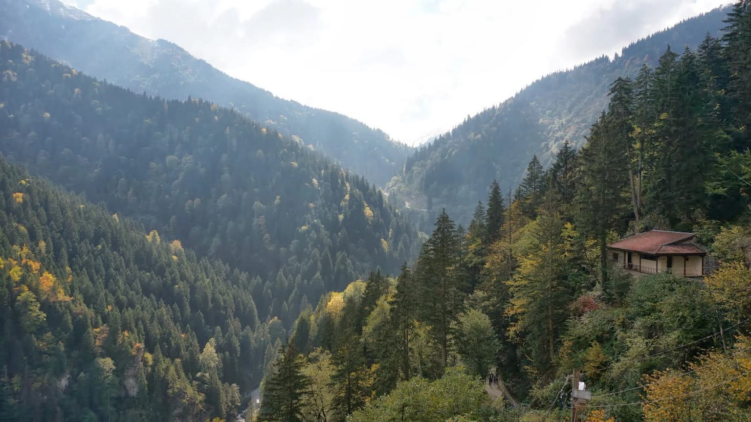
The landscape of Altındere Valley National Park is defined by the rugged topography of the Pontic Mountains rising from the Black Sea coast. The Altındere River has carved a deep, steep-sided valley through the mountain terrain, creating the dramatic gorge that forms the park's central geography. The valley walls rise sharply from the water's edge, with the Sümela Monastery clinging to a cliff face approximately 270 meters above the valley floor—an elevation that places the monastery above the valley's typical cloud layer, contributing to its ethereal appearance. The surrounding slopes are covered in dense montane vegetation typical of the Black Sea region's maritime climate, with forests covering much of the terrain. Rocky cliff faces, waterfalls, and narrow gorges characterize the valley's more dramatic sections, while broader areas of forest and meadow occur on more gentle terrain. The overall impression is one of dramatic verticality and natural beauty, where the monastery's construction on the cliff face appears to be an extension of the landscape itself rather than an imposition upon it.

Stone monastery built into a cliffside with lush green vegetation, viewed from a valley across rocky terrain
Sümela Monastery viewed from across Altındere Valley in Turkey

Altındere Valley National Park ecosystems, habitats, and plant life

The natural environment of Altındere Valley National Park reflects the extraordinary ecological diversity of the Pontic Mountain range in northeastern Turkey. The Black Sea region's climate creates conditions of high humidity and significant precipitation, supporting lush forest growth across the mountain slopes. The park encompasses montane forest ecosystems that transition from lower broadleaf forests through mixed forest zones to higher elevation vegetation. These forests support significant biodiversity, including species characteristic of the region's unique flora and fauna. The steep terrain and varied elevations create multiple habitat types within the park boundaries, from river valley floor to cliff face and ridge top. The protection granted by national park status helps preserve these ecological communities and the watershed functions the area provides, ensuring the maintenance of both the natural systems and the spectacular landscape setting that makes the monastery location so distinctive.

Altındere Valley National Park wildlife and species highlights

The wildlife of Altındere Valley National Park is characteristic of the montane forest ecosystems of the Pontic Mountains in northeastern Turkey. The dense forests covering the valley slopes provide habitat for a variety of bird species and mammal species adapted to this mountainous environment. The region's position at the crossroads of different climatic and ecological zones contributes to species diversity, with both European and Asian species represented in the local fauna. While specific species documentation would require detailed wildlife surveys, the protected forest environments support populations of common forest-dwelling species including various songbirds, raptors, and small mammals. The rocky cliff faces and forest edges create diverse microhabitats that support additional species. The national park designation helps ensure these wildlife populations and their habitats are maintained within the broader conservation framework protecting this region's natural heritage.

Altındere Valley National Park conservation status and protection priorities

Altındere Valley National Park represents an important conservation designation that protects both cultural heritage and natural ecosystems within a single protected area. The national park status, established in 1987, provides legal protection for the Sümela Monastery complex and its dramatic setting, ensuring that development pressures and inappropriate uses do not degrade this significant cultural and visual landscape. Simultaneously, the protection encompasses the montane forest ecosystems of the Altındere valley, preserving the watershed, forest communities, and associated wildlife within a formal conservation framework. The park is managed by Turkey's Ministry of Forest and Water Management, which oversees protection, visitor management, and resource stewardship activities. This dual focus—on cultural monument preservation and natural ecosystem protection—makes the park an example of integrated conservation that recognizes both the built heritage and the natural environment as essential components of the area's outstanding universal value.

Altındere Valley National Park cultural meaning and human context

The cultural significance of Altındere Valley National Park extends far beyond the physical monument of the Sümela Monastery to encompass the broader historical relationship between the Black Sea region's peoples and its mountainous landscape. The monastery represents a continuity of religious use spanning over 1,600 years, from its founding in the late Roman period through the Byzantine Empire, the Empire of Trebizond, and into the modern era. The site's selection for the monastery's location—on a seemingly inaccessible cliff face—reflects the tradition of establishing sacred spaces in dramatic natural settings that emphasize spiritual transcendence. The complex includes not only the famous cliff-side churches and chapels but also supporting structures including a library, kitchen, and residential quarters, representing a complete monastic community. The 14th-century period under Emperor Alexius III represents the most significant phase of development, with the emperor's coronation at the site demonstrating its importance as a spiritual and political center. The monastery also holds significance as a pilgrimage destination, with the tradition of holy pilgrimage continuing among visitors to this day.

Top sights and standout views in Altındere Valley National Park

The Sümela Monastery is the overwhelming highlight of Altındere Valley National Park, with its position on a 270-meter cliff face creating one of the most dramatic religious sites in the world. The monastery complex encompasses multiple churches and chapels, including the main church and the dedicated Aya Varvara church accessible via mountain paths. The setting—appearing to float above the valley and often above the clouds—creates an unforgettable visual experience that has made the site one of Turkey's most photographed locations. The surrounding valley offers additional natural beauty, with the forested slopes, river gorge, and mountain backdrop providing context for the monumental structure. The combination of natural setting, historical depth spanning sixteen centuries, and architectural achievement makes this one of Turkey's most significant protected cultural landscapes.

Best time to visit Altındere Valley National Park

The best time to visit Altındere Valley National Park depends on what visitors hope to experience, though certain seasonal considerations apply. The Black Sea region's climate means the area receives significant precipitation, particularly during autumn and winter months, making spring and early summer generally more favorable for visitor access and enjoyment. Summer months offer the most stable weather conditions, though they also coincide with peak tourist season and larger crowds at the monastery. The dramatic mountain setting means that visibility and atmospheric conditions vary considerably—the monastery appears most dramatic when emerging above cloud layers, which occurs particularly in spring and autumn mornings. Winter visits offer fewer visitors and a different perspective on the landscape, though some facilities may have reduced accessibility. The monastery is a year-round site, but visitors should be prepared for variable mountain weather conditions regardless of season.

Park location guide

Geography guide, regional context, and park location map for Altındere Valley National Park

Altındere Valley National Park park geography, regions, and map view in Turkey
Understand where Altındere Valley National Park sits in Turkey through a broader geographic reading of the surrounding landscape, nearby location context, and its mapped position within the national park landscape.

How Altındere Valley National Park fits into Turkey

Turkey, officially the Republic of Türkiye, is a transcontinental country located mainly in Anatolia (West Asia) with a smaller portion in East Thrace (Southeast Europe). It borders the Black Sea to the north, several countries to the east and south, and the Aegean Sea and European countries to the west. The country has a population of over 86 million and operates as a secular, Muslim-majority presidential republic with Ankara as capital and Istanbul as its largest city.

Wider geography shaping Altındere Valley National Park in Turkey

Turkey is a transcontinental country with the majority of its territory (about 97%) located in Anatolia (West Asia) and a smaller portion called East Thrace in Southeast Europe. It borders the Black Sea to the north, Georgia, Armenia, Azerbaijan, and Iran to the east, Iraq and Syria to the south, and the Mediterranean Sea to the southwest. To the west, Turkey borders the Aegean Sea, Greece, and Bulgaria. The terrain includes mountains, plateaus, and coastal plains, with the Taurus Mountains running along the southern coast.

Map view of Altındere Valley National Park

Use this park location map to pinpoint Altındere Valley National Park in Turkey, understand its exact geographic position, and read its mapped placement within the surrounding landscape more clearly.

Pigeon | © OpenStreetMap contributors

Location context for Altındere Valley National Park

Trabzon Province

Immersive Views of Altındere Valley's Montane Forests, Steep Gorges, and the Historic Cliff-side Monastery

Altındere Valley National Park: Visual Exploration of its Protected Landscapes and Iconic Sümela Monastery Views
Browse a curated collection of park imagery showcasing the dramatic terrain, dense montane forests, and unique protected-area environment of Altındere Valley National Park. These visuals provide essential geographic and landscape context, revealing its deep river gorges, rocky habitats, and the iconic cliff-perched Sümela Monastery for deeper park understanding.

A wide valley between forested mountains with a small building on the slope

Stone monastery built into a cliffside with lush green vegetation, viewed from a valley across rocky terrain

Park atlas

Trace the regional spread of protected areas and forest reserves across Turkey's Pontic Mountains and Black Sea region.

Compare Nearby National Parks and Protected Areas Beyond Altındere Valley National Park
Expand your atlas exploration by browsing other national parks and protected areas located near Altındere Valley National Park and within the broader Trabzon Province. Compare diverse landscapes, from deep river gorges to montane forests, and discover additional conservation sites across Turkey's Black Sea region.
National parkBayburt Province

Mount Kop Defense National Historic Park: A Protected WWI Battlefield and Biodiversity Hotspot

Mapped protected area in Bayburt Province, Turkey.

Delve into Mount Kop Defense National Historic Park, a protected national park situated in the mountainous terrain of Bayburt Province, Turkey. This site is distinguished by its preserved World War I battlefield features and remarkable biodiversity, particularly its status as a critical habitat for numerous high-altitude butterfly species. Explore the mapped geography and unique conservation value of this significant protected landscape, understanding its distinct place within regional natural and historical atlases.

Area
6.335 km²
Established
2016
Relief
Mountain
Climate
Subpolar
National parkTunceli Province

Munzur Valley National Park: Tunceli Province's Vast Protected Alpine Landscape

Discover Turkey's largest national park and its unique mountain geography.

Munzur Valley National Park stands as a monumental protected area within Tunceli Province, Turkey. Its expansive territory encompasses approximately 420 square kilometers of dramatic mountain ranges, deep river valleys, and high-altitude glacial lakes. The park's complex geological makeup, shaped by tectonic forces and glacial activity, contributes to its unique terrain. This atlas entry highlights the park's role as a major biodiversity hotspot and a significant feature within eastern Anatolia's regional geography, offering rich context for landscape exploration.

Area
420 km²
Established
1971
IUCN
II
Watercolor illustration of a winding river through green hills with pink flowers in the foreground
National parkArtvin Province

Hatila Valley National Park: Dramatic V-Shaped Valley and Volcanic Terrain in Artvin Province

Explore protected landscape, waterfalls, and botanical diversity.

Hatila Valley National Park represents a significant protected area within Artvin Province, Turkey, notable for its exceptionally steep, V-shaped river valley. This national park features a striking volcanic landscape characterized by deep gorges, numerous waterfalls, and unique geomorphological structures. Its rich botanical diversity, with 769 documented plant species including many endemics, positions it as a key site for understanding protected landscapes and regional flora. The park's geographic setting at the eastern end of the Kaçkar Mountains provides context for its Mediterranean climate and varied terrain.

Area
169 km²
Established
1994
Relief
Mountain
Climate
Mediterranean
National parkAdjara

Machakhela National Park: Adjara's Colchic Forest Protected Landscape

Explore Georgia's unique Caucasus mountain geography and mapped park boundaries.

Machakhela National Park represents a crucial protected area in Georgia's Adjara region, safeguarding the integrity of ancient Colchic broadleaf forests. This park's landscape is characterized by the steep Machakhelistsqali River valley, carved into the lower Caucasus mountains, offering a distinct geographic profile for atlas exploration. Discover the park's specific terrain, mapped boundaries, and its ecological significance as a vital component of the regional natural heritage.

Area
130.7 km²
Established
2012
IUCN
II
Relief
Mixed relief
Watercolor illustration of a landscape with green hills, trees, and a body of water
National parkAdjara

Mtirala National Park: Protected Colchic Rainforest Landscape & Geographic Atlas

Explore Adjara's unique terrain and mapped protected boundaries.

Mtirala National Park, located in Georgia's Adjara region, is a protected national park renowned for its exceptionally high rainfall and ancient Colchic relict forests. This atlas-focused profile details the park's unique topography, its watershed between the Chakvistskali and Khoristskali rivers, and its significance as a vital ecosystem. Understand the geographic context of this protected landscape and its role in the broader Caucasus geography.

Area
281.26 km²
Established
2006
IUCN
II
Relief
Mixed relief
Watercolor illustration of a landscape with rolling hills, forests, and a winding river.
National parkAdjara

Kintrishi National Park: Protected Colchic Forest Canyon Landscape in Adjara

Explore the mapped geographic boundaries of this unique Georgian national park.

Kintrishi National Park, located in Georgia's Adjara region, is a protected landscape renowned for its exceptionally intact Colchic deciduous forests within a steep river gorge. This area showcases dense woodland, dramatic terrain, and the unique Colchican willow species, offering rich geographic context. As a key protected area, Kintrishi National Park provides a valuable focus for atlas-based exploration of southwestern Georgia's natural heritage.

Area
186.84 km²
Established
2007
IUCN
II
Scope
Terrestrial
National parkGeorgia

Kolkheti National Park: Mapped Wetland Landscape & Protected Area in Georgia

Explore the peat bogs, coastal ecosystems, and bird migration routes.

Discover Kolkheti National Park, a key protected national park located in Georgia's western coastal region. This atlas entry focuses on the park's extensive wetland environments, including its significant peat bogs and Lake Paliastomi, highlighting its role as a critical migratory bird corridor and a unique natural landscape within the Black Sea region. Understand its geographic context and protected area boundaries.

Area
807.99 km²
Established
1998
IUCN
II
Visitors
13.7K annual
Watercolor painting showing mountains, trees, and a lake in soft green and blue tones
National parkArtvin Province

Karagöl-Sahara National Park: Mapped Highland Lake and Plateau Protected Area

Discover Artvin Province's unique landslide lake and alpine terrain.

Karagöl-Sahara National Park presents a compelling protected landscape in Artvin Province, Turkey, renowned for its dramatic landslide lake, Karagöl, and the expansive Sahara plateau. This national park provides a unique map of highland geography, featuring dense conifer forests that give way to alpine meadows at elevations around 1,800 meters. Examine the geological character, including active landslide zones and sedimentary formations, that shape this distinctive terrain and contribute to its protected ecological value within the Black Sea Region.

Area
32.51 km²
Established
1994
Relief
Mountain
Climate
Boreal

Common questions about visiting, size, designation, and location context for Altındere Valley National Park

Altındere Valley National Park FAQs for park facts, access, geography, and protected area context
Find quick answers about Altındere Valley National Park, including protected-area facts, park geography, trail and visitor context, and how the park fits into its surrounding country and regional landscape.
MoriAtlas Explorer

Continue Your Protected Areas Search Across the Global Atlas

Deepen your exploration by continuing the structured search for national parks and protected areas worldwide. Utilize the comprehensive filtering capabilities to compare different conservation landscapes and refine your understanding of global park geography. Discover more about the distribution and characteristics of protected natural areas.

Global natural geography