Mori Atlas logo
National parkHatila Valley National Park

Discover the dramatic V-shaped valley, waterfalls, and endemic flora of this Artvin Province national park.

Hatila Valley National Park: A Protected Landscape of Volcanic Terrain and Botanical Richness

(Hatila Vadisi Millî Parkı)

Hatila Valley National Park, established on August 31, 1994, protects a significant expanse of dramatic V-shaped river valley within Artvin Province, northeastern Turkey. This national park showcases a unique volcanic landscape, carved by the Hatila River into a terrain of steep gorges and multiple waterfalls. Its exceptional botanical diversity, featuring 769 plant species and numerous endemics, highlights its importance as a protected landscape. Explore the mapped boundaries and regional geographic context of Hatila Valley National Park, a key feature of the Kaçkar Mountains' eastern reaches.

National ParkTurkeyKaçkar MountainsVolcanic LandscapeRiver ValleyWaterfalls
Illustration of a mountain valley with a river, surrounded by forests and rocky cliffs under a light sky

Hatila Valley National Park

National park

Park overview

Structured park overview, official facts, and landscape profile for Hatila Valley National Park

Hatila Valley National Park park facts, protected area profile, and essential visitor context
Review the core facts for Hatila Valley National Park, including designation, size, terrain, visitor scale, habitats, and operating context in one park-focused overview.

About Hatila Valley National Park

Hatila Valley National Park protects one of Turkey's most geologically distinctive mountain valleys, where the Hatila River has carved a deep V-shaped gorge through volcanic terrain at the eastern end of the Kaçkar Mountains range. The valley's steep-sided walls, reaching nearly vertical in places, create a dramatic landscape of waterfalls, cascades, and narrow canyons. The geological character is unusual—the bedrock consists primarily of volcanic rocks that have produced an intricate terrain with varied slope structures and rock formations. The park's location near the Black Sea subjects it to Mediterranean climatic influences, with mild temperatures and substantial precipitation supporting lush vegetation throughout the valley. The combination of dramatic topography, rich plant communities, and diverse wildlife makes this a significant conservation area within Turkey's protected lands system.

Quick facts and research context for Hatila Valley National Park

Hatila Valley National Park is located in Artvin Province, northeastern Turkey, about 10 kilometers from the city of Artvin. The park occupies roughly 16,900 hectares along a V-shaped valley carved by the Hatila River as it descends from the Kaçkar Mountains toward the Çoruh River. The valley features steep slopes reaching 80-100% gradient in places, with volcanic bedrock and a series of waterfalls created by geological fault lines. The climate is Mediterranean-influenced, supporting both deciduous and evergreen forest communities across the valley's elevation gradient.

Park context

Deeper park guide and search-rich context for Hatila Valley National Park

Hatila Valley National Park history, landscape, wildlife, and travel context
Explore Hatila Valley National Park through its history, landscape character, ecosystems, wildlife, conservation priorities, cultural context, and seasonal travel timing in a structured park guide built for atlas discovery and search intent.

Why Hatila Valley National Park stands out

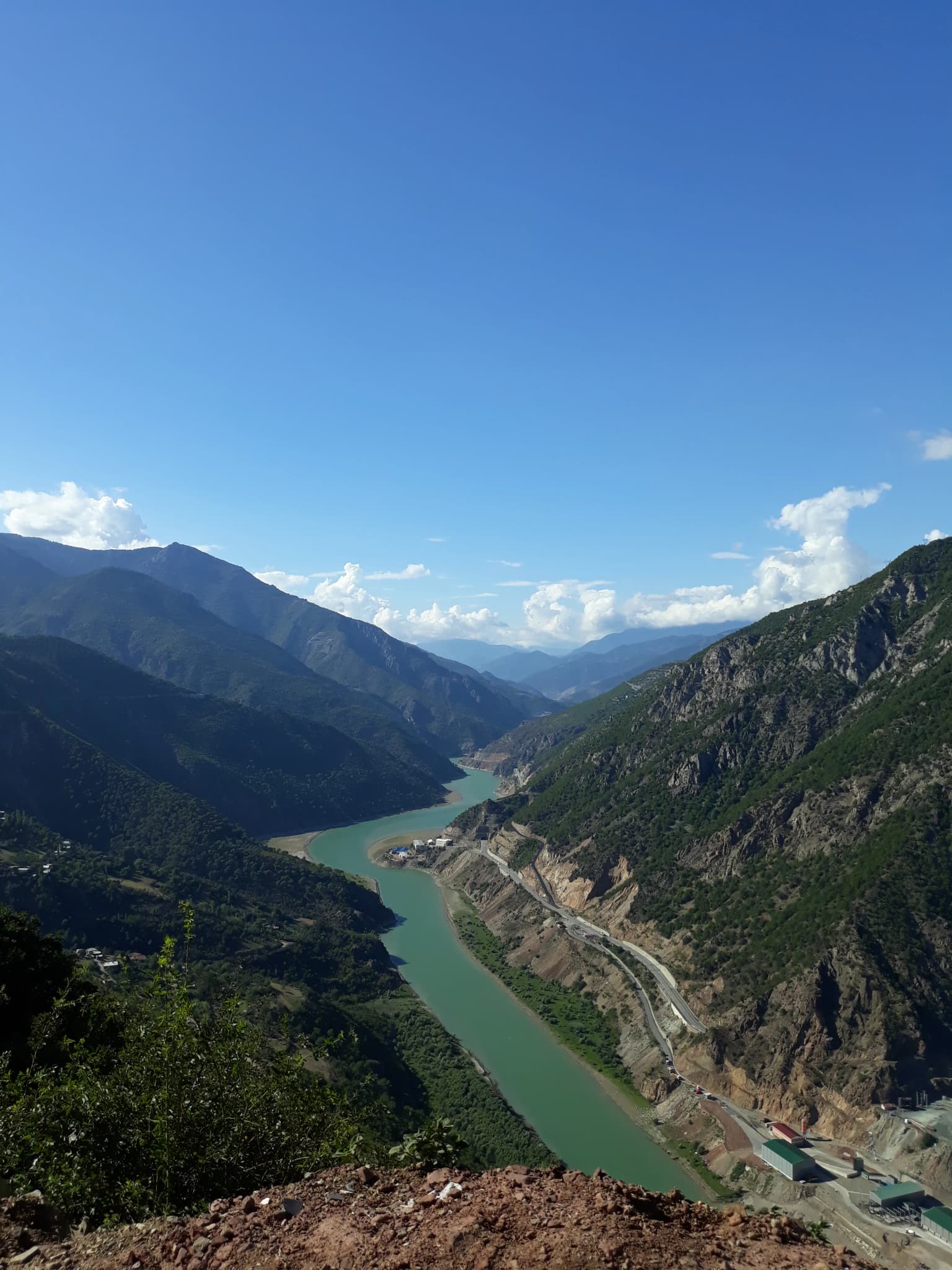
Hatila Valley is best known for its dramatic V-shaped river valley with multiple waterfalls, its exceptional botanical diversity spanning 769 plant species, and its location at the eastern edge of the Kaçkar Mountains. The valley's volcanic geology has created an unusual and distinctive landscape with canyon and gorge formations in its middle reaches. The park preserves a relict Mediterranean flora with over 500 endemic plant species, including several rare snowdrop species and orchids. Its position along a major bird migration route also makes it significant for avian diversity.

Wide-angle view of a turquoise river flowing through a mountainous valley with steep rocky cliffs and lush green vegetation under a clear blue sky.
Panoramic view of Hatila Valley National Park with the turquoise river winding through steep mountain slopes under a clear blue sky.

Hatila Valley National Park history and protected-area timeline

Hatila Valley was established as a national park on August 31, 1994, by the Turkish Ministry of Forest and Water Management. Prior to national park designation, the area had been managed as a forest reserve with conservation implications. The formal establishment recognized both the valley's outstanding natural beauty and its ecological significance, particularly the botanical diversity documented in subsequent surveys. Between 1994 and 1997, a comprehensive botanical survey documented 769 plant species in the park, establishing its importance as one of Turkey's most botanically diverse protected areas. The park remains under the management authority of Turkey's Ministry of Forest and Water Management.

Hatila Valley National Park landscape and geographic character

The physical landscape of Hatila Valley is defined by a young, narrow valley with a V-shaped cross-section and steep-gradient slopes that in some sections reach 80-100% incline. The valley floor is narrow, with the river having downcut more aggressively than it has laterally eroded, producing the characteristic steep-sided profile. The underlying geology is entirely volcanic in origin, with various rock types resulting from deep-source volcanism. These lithological variations, combined with differential erosion, have created a series of fault-line waterfalls along the valley's length. The middle sections of the valley exhibit canyon and gorge characteristics where the topography is most constrained. The overall terrain is rugged and complex, with multiple micro-climates developing across the elevation gradient. The landscape supports dense vegetation in the middle and lower sections, contrasting with the more barren upper reaches where rocky slopes predominate.

Hatila Valley National Park ecosystems, habitats, and plant life

The ecological character of Hatila Valley reflects its Mediterranean climate influence and varied topography. The forests covering the mountain slopes include both deciduous and evergreen species—sessile oak, sweet chestnut, oriental hornbeam, common hornbeam, black alder, oriental beech, oriental spruce, Caucasian fir, and Scots pine form the primary arboreal communities. At higher elevations, common aspen joins these species along with rhododendron, juniper, Vaccinium, willow, birch, and European raspberry. The valley floor supports a dense herbaceous layer with exceptionally long botanical seasons, as different zones flower at different times from spring through autumn. The lower valley awakens in spring with hellebores, Cyclamen coum, Omphalodes cappadocica, and Primula vulgaris subsp. sibthorpii, while higher elevations bloom weeks later with additional primulas and multiple snowdrop species including the recently described Galanthus koenenianus. Summer brings cranesbill species, globe flowers, louseworts, and diverse terrestrial orchids to the hay meadows and forest glades. The park contains over 500 endemic plant species, with vegetation patterns reflecting a relict Mediterranean character that is rare in Turkey.

Hatila Valley National Park wildlife and species highlights

The wildlife community of Hatila Valley includes several notable large mammal species. Grey wolves, red foxes, lynx, leopards, and brown bears inhabit the forested slopes, along with wild goats, chamois, roe deer, wild boar, and European hares. This predator-prey community represents the complete mammal assemblage typical of Turkey's mountain forests. The bird fauna is particularly significant due to the valley's position along major migration routes between Europe and the Middle East. Golden eagles, long-legged buzzards, and peregrine falcons pass through during seasonal migrations. Resident bird species include Caucasian grouse, chukar partridge, and grey partridge. The Turkish source additionally mentions Caspian snowcock among the notable avian residents. The river systems support trout populations, while the reptile community includes species such as the Hopa snake.

Hatila Valley National Park conservation status and protection priorities

Hatila Valley National Park represents an important conservation priority within Turkey's protected area network. The park preserves both significant geological features—a rare volcanic valley landscape with unique geomorphological character—and exceptional botanical diversity with over 500 endemic species. The presence of several newly described plant species, including Galanthus koenenianus, demonstrates that the area continues to yield new scientific discoveries. The Mediterranean climate relict vegetation communities are considered particularly valuable, as they represent survival of plant species assemblages from earlier climatic periods. The park protects habitat for predator species including wolves, lynx, leopards, and brown bears, maintaining ecological processes in this section of the Kaçkar Mountains.

Hatila Valley National Park cultural meaning and human context

The park lies within Artvin Province, home to a regional population with strong connections to the land and traditional mountain livelihoods. The valley has historically served as rangeland and forest resource area for local communities. The proximity to Artvin city—just 10 kilometers via a maintained road—means the park serves as an accessible natural area for regional residents. While the park itself does not contain explicit archaeological or historical monuments, the broader Artvin region includes cultural heritage from various periods, and the valley's steep terrain has historically provided natural defenses that influenced regional settlement patterns. The Turkish name Hatila Vadisi Millî Parkı reflects the local toponym for the valley.

Top sights and standout views in Hatila Valley National Park

The defining features of Hatila Valley National Park include its spectacular V-shaped valley carved by the Hatila River, the series of waterfalls created by geological fault lines, and the extraordinarily rich plant community with 769 documented species. The volcanic geology has produced unusual landforms including canyon and gorge sections in the valley's middle reaches. The presence of endemic species and rare plants, including several snowdrop varieties and diverse orchids, underscores the botanical significance. The park also protects significant wildlife including brown bears, wolves, lynx, leopards, and the distinctive Caucasian grouse.

Best time to visit Hatila Valley National Park

The valley offers distinctive experiences across seasons. Spring brings the earliest blooms to the lower elevations beginning in late winter, with different zones flowering progressively through spring as temperatures rise with altitude. Summer represents peak season for the higher meadows and alpine zones, when the hay meadows and forest glades display their full floral diversity. Autumn features crocus and colchicum blooms in the higher areas and offers the characteristic golden coloration of deciduous forests. Winter brings snow to higher elevations, transforming the landscape and offering a very different visual experience. The valley's Mediterranean climate means precipitation occurs throughout the year, with the wettest conditions typically in autumn and winter.

Park location guide

Geography guide, regional context, and park location map for Hatila Valley National Park

Hatila Valley National Park park geography, regions, and map view in Turkey
Understand where Hatila Valley National Park sits in Turkey through a broader geographic reading of the surrounding landscape, nearby location context, and its mapped position within the national park landscape.

How Hatila Valley National Park fits into Turkey

Turkey, officially the Republic of Türkiye, is a transcontinental country located mainly in Anatolia (West Asia) with a smaller portion in East Thrace (Southeast Europe). It borders the Black Sea to the north, several countries to the east and south, and the Aegean Sea and European countries to the west. The country has a population of over 86 million and operates as a secular, Muslim-majority presidential republic with Ankara as capital and Istanbul as its largest city.

Wider geography shaping Hatila Valley National Park in Turkey

Turkey is a transcontinental country with the majority of its territory (about 97%) located in Anatolia (West Asia) and a smaller portion called East Thrace in Southeast Europe. It borders the Black Sea to the north, Georgia, Armenia, Azerbaijan, and Iran to the east, Iraq and Syria to the south, and the Mediterranean Sea to the southwest. To the west, Turkey borders the Aegean Sea, Greece, and Bulgaria. The terrain includes mountains, plateaus, and coastal plains, with the Taurus Mountains running along the southern coast.

Map view of Hatila Valley National Park

Use this park location map to pinpoint Hatila Valley National Park in Turkey, understand its exact geographic position, and read its mapped placement within the surrounding landscape more clearly.

Pigeon | © OpenStreetMap contributors

Location context for Hatila Valley National Park

Artvin Province

Explore the dramatic V-shaped river valley, volcanic formations, and rich botanical habitats through curated imagery

Hatila Valley National Park Photos, Scenery, and Landscapes: A Visual Guide to its Unique Terrain
Explore the captivating landscapes of Hatila Valley National Park through a comprehensive collection of images. These photographs provide visual insight into its steep V-shaped river valley, unique volcanic geology, and dramatic waterfalls. Understand the park's diverse botanical environments and protected natural character through this detailed visual atlas.

Wide-angle view of a turquoise river flowing through a mountainous valley with steep rocky cliffs and lush green vegetation under a clear blue sky.

Illustration of a black grouse with red head patch perched on a branch, another bird in flight, and pine trees in background

Park atlas

Explore the Diverse Protected Landscapes and Regional Park Geography of Artvin Province, Turkey

Discover More National Parks and Protected Areas Near Hatila Valley National Park
Browse other remarkable protected areas and national parks located within or adjacent to Hatila Valley National Park and Artvin Province in northeastern Turkey. Comparing these regional conservation landscapes allows for deeper atlas-style exploration of distinct volcanic geology, river valleys, and botanical diversity across the Kaçkar Mountains region.
National parkAdjara

Machakhela National Park: Adjara's Colchic Forest Protected Landscape

Explore Georgia's unique Caucasus mountain geography and mapped park boundaries.

Machakhela National Park represents a crucial protected area in Georgia's Adjara region, safeguarding the integrity of ancient Colchic broadleaf forests. This park's landscape is characterized by the steep Machakhelistsqali River valley, carved into the lower Caucasus mountains, offering a distinct geographic profile for atlas exploration. Discover the park's specific terrain, mapped boundaries, and its ecological significance as a vital component of the regional natural heritage.

Area
130.7 km²
Established
2012
IUCN
II
Relief
Mixed relief
Watercolor illustration of a landscape with green hills, trees, and a body of water
National parkAdjara

Mtirala National Park: Protected Colchic Rainforest Landscape & Geographic Atlas

Explore Adjara's unique terrain and mapped protected boundaries.

Mtirala National Park, located in Georgia's Adjara region, is a protected national park renowned for its exceptionally high rainfall and ancient Colchic relict forests. This atlas-focused profile details the park's unique topography, its watershed between the Chakvistskali and Khoristskali rivers, and its significance as a vital ecosystem. Understand the geographic context of this protected landscape and its role in the broader Caucasus geography.

Area
281.26 km²
Established
2006
IUCN
II
Relief
Mixed relief
Watercolor painting showing mountains, trees, and a lake in soft green and blue tones
National parkArtvin Province

Karagöl-Sahara National Park: Mapped Highland Lake and Plateau Protected Area

Discover Artvin Province's unique landslide lake and alpine terrain.

Karagöl-Sahara National Park presents a compelling protected landscape in Artvin Province, Turkey, renowned for its dramatic landslide lake, Karagöl, and the expansive Sahara plateau. This national park provides a unique map of highland geography, featuring dense conifer forests that give way to alpine meadows at elevations around 1,800 meters. Examine the geological character, including active landslide zones and sedimentary formations, that shape this distinctive terrain and contribute to its protected ecological value within the Black Sea Region.

Area
32.51 km²
Established
1994
Relief
Mountain
Climate
Boreal
Watercolor illustration of a landscape with rolling hills, forests, and a winding river.
National parkAdjara

Kintrishi National Park: Protected Colchic Forest Canyon Landscape in Adjara

Explore the mapped geographic boundaries of this unique Georgian national park.

Kintrishi National Park, located in Georgia's Adjara region, is a protected landscape renowned for its exceptionally intact Colchic deciduous forests within a steep river gorge. This area showcases dense woodland, dramatic terrain, and the unique Colchican willow species, offering rich geographic context. As a key protected area, Kintrishi National Park provides a valuable focus for atlas-based exploration of southwestern Georgia's natural heritage.

Area
186.84 km²
Established
2007
IUCN
II
Scope
Terrestrial
National parkGeorgia

Kolkheti National Park: Mapped Wetland Landscape & Protected Area in Georgia

Explore the peat bogs, coastal ecosystems, and bird migration routes.

Discover Kolkheti National Park, a key protected national park located in Georgia's western coastal region. This atlas entry focuses on the park's extensive wetland environments, including its significant peat bogs and Lake Paliastomi, highlighting its role as a critical migratory bird corridor and a unique natural landscape within the Black Sea region. Understand its geographic context and protected area boundaries.

Area
807.99 km²
Established
1998
IUCN
II
Visitors
13.7K annual
National parkTurkey

Sarıkamış-Allahuekber Mountains National Park: High-Altitude Protected Forest and WWI Memorial Landscape in Turkey

Explore the distinct protected terrain and historical geography of Turkey's eastern highlands.

Sarıkamış-Allahuekber Mountains National Park offers a unique exploration of high-altitude protected lands in Turkey. This national park is characterized by its remarkable pure Caucasian pine forests that thrive at elevations typically above the tree line, showcasing a rare alpine ecosystem. The park's rugged mountain terrain, marked by significant historical sites from the Battle of Sarikamish, provides a profound connection between natural landscape and human history within its mapped boundaries. Discover the geographic setting and protected status of this distinctive area.

Area
225.19 km²
Established
2004
Relief
Mountain
Scope
Terrestrial
National parkGeorgia

Borjomi-Kharagauli National Park: Protected Landscape Atlas of Georgia's Lesser Caucasus

Explore its unique forests, wildlife, and mountain terrain.

Delve into Borjomi-Kharagauli National Park, a significant protected area in Georgia's Lesser Caucasus region. This national park is renowned for its extensive old-growth forests, including rare Colchian fragments, and a remarkable concentration of endemic species. The park's dramatic mountainous terrain, spanning over 1,000 square kilometers, offers a rich tapestry of landscapes from deep valleys to alpine meadows, providing critical habitat for large mammals and contributing significantly to the region's biodiversity. Explore its mapped boundaries and geographic context for a deeper understanding of this vital conservation landscape.

Area
1,093 km²
Established
1995
IUCN
II
Relief
Mountain
Watercolor painting of green and pink mountain ranges under a light sky background
National parkSamtskhe–Javakheti

Javakheti National Park: Protected Highland Landscape and Wetland Atlas

Explore the unique geography and mapped park boundaries of this Georgian protected area.

Delve into Javakheti National Park, a significant protected landscape located in Georgia's Samtskhe, Javakheti region. This page serves as an entry point for understanding the park's distinctive highland terrain, its remarkable chain of lakes and marshes, and its protected area status. Explore the geographic context of this national park, its role in wetland conservation, and its value for structured atlas-based discovery of natural landscapes.

Area
238.53 km²
Established
2011
IUCN
II
Relief
Mixed relief

Common questions about visiting, size, designation, and location context for Hatila Valley National Park

Hatila Valley National Park FAQs for park facts, access, geography, and protected area context
Find quick answers about Hatila Valley National Park, including protected-area facts, park geography, trail and visitor context, and how the park fits into its surrounding country and regional landscape.
MoriAtlas Explorer

Continue Your Protected Areas Search Across the Global Atlas

Deepen your exploration by continuing the structured search for national parks and protected areas worldwide. Utilize the comprehensive filtering capabilities to compare different conservation landscapes and refine your understanding of global park geography. Discover more about the distribution and characteristics of protected natural areas.

Global natural geography