Mori Atlas logo
National parkKintrishi National Park

Discover the mapped boundaries and protected landscape of this unique Georgian national park.

Kintrishi National Park: Exploring a Colchic Forest Canyon in Adjara, Georgia

(Kintrishi Protected Areas)

Kintrishi National Park, situated in the Adjara region of southwestern Georgia, represents a vital protected landscape focused on preserving the rare Colchic deciduous forest ecosystem. This national park encompasses the striking Kintrishi River gorge, descending from the Meskheti Mountains towards the Black Sea coast. As a Category II IUCN protected area, it offers a unique opportunity to explore a dramatic canyon terrain cloaked in dense woodland, providing critical geographic and landscape context for this significant natural heritage site.

national parkprotected landscapeColchic forestriver canyon deciduous forestCaucasus
Illustration of a stone bridge covered in vines over a river with mountains and forests in the background

Kintrishi National Park

National park

Park overview

Structured park overview, official facts, and landscape profile for Kintrishi National Park

Kintrishi National Park park facts, protected area profile, and essential visitor context
Review the core facts for Kintrishi National Park, including designation, size, terrain, visitor scale, habitats, and operating context in one park-focused overview.

About Kintrishi National Park

Kintrishi National Park protects a visually striking river canyon where the Kintrishi River has carved a deep passage through the forested hills of southwestern Georgia. The park lies within the Kobuleti Municipality of Adjara, an autonomous republic in western Georgia, positioned between the greater Caucasus Mountains to the north and the Black Sea coastline to the west. This location places the protected area at the intersection of several ecological zones, where humid subtropical influences from the coast meet montane forest communities on the ascending slopes. The terrain is dominated by steep-sided valleys, rocky outcrops, and the persistent sound of flowing water, creating an environment that feels distinctly wild relative to the agricultural and resort landscapes surrounding Kobuleti. The park's establishment in 2007 represented Georgia's commitment to protecting its remaining Colchic forest fragments, a biome that has been dramatically reduced by centuries of human land use across the region. The protected area forms part of a broader conservation complex that incorporates the older Kintrishi Strict Nature Reserve, which was first designated in 1959 and represents the most strictly protected core of the ecosystem. Together, these designations create a zoned approach to conservation that allows for both strict habitat preservation and sustainable visitor access. The park attracts those interested in forest ecosystems, scenic river landscapes, and Georgia's growing network of protected areas that showcase the country's natural diversity.

Quick facts and research context for Kintrishi National Park

Kintrishi National Park occupies the river canyon system in western Georgia's Adjara region, near the coastal town of Kobuleti. The protected area was formally designated in 2007, though the adjacent strict nature reserve dates to 1959, making this one of Georgia's longer-established conservation landscapes. The park is renowned for its Colchican willow trees, a distinctive element of the Colchis forest biome that once covered much of Georgia's Black Sea coastal lowlands. Archaeological investigations within the protected area have uncovered pre-Christian monuments, indicating long human association with this landscape. A notable cultural feature is a 12th-century arched stone bridge crossing the Kintrishi River, demonstrating centuries of settlement and travel through this mountain corridor.

Park context

Deeper park guide and search-rich context for Kintrishi National Park

Kintrishi National Park history, landscape, wildlife, and travel context
Explore Kintrishi National Park through its history, landscape character, ecosystems, wildlife, conservation priorities, cultural context, and seasonal travel timing in a structured park guide built for atlas discovery and search intent.

Why Kintrishi National Park stands out

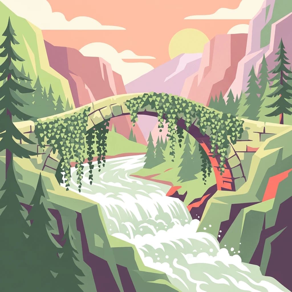
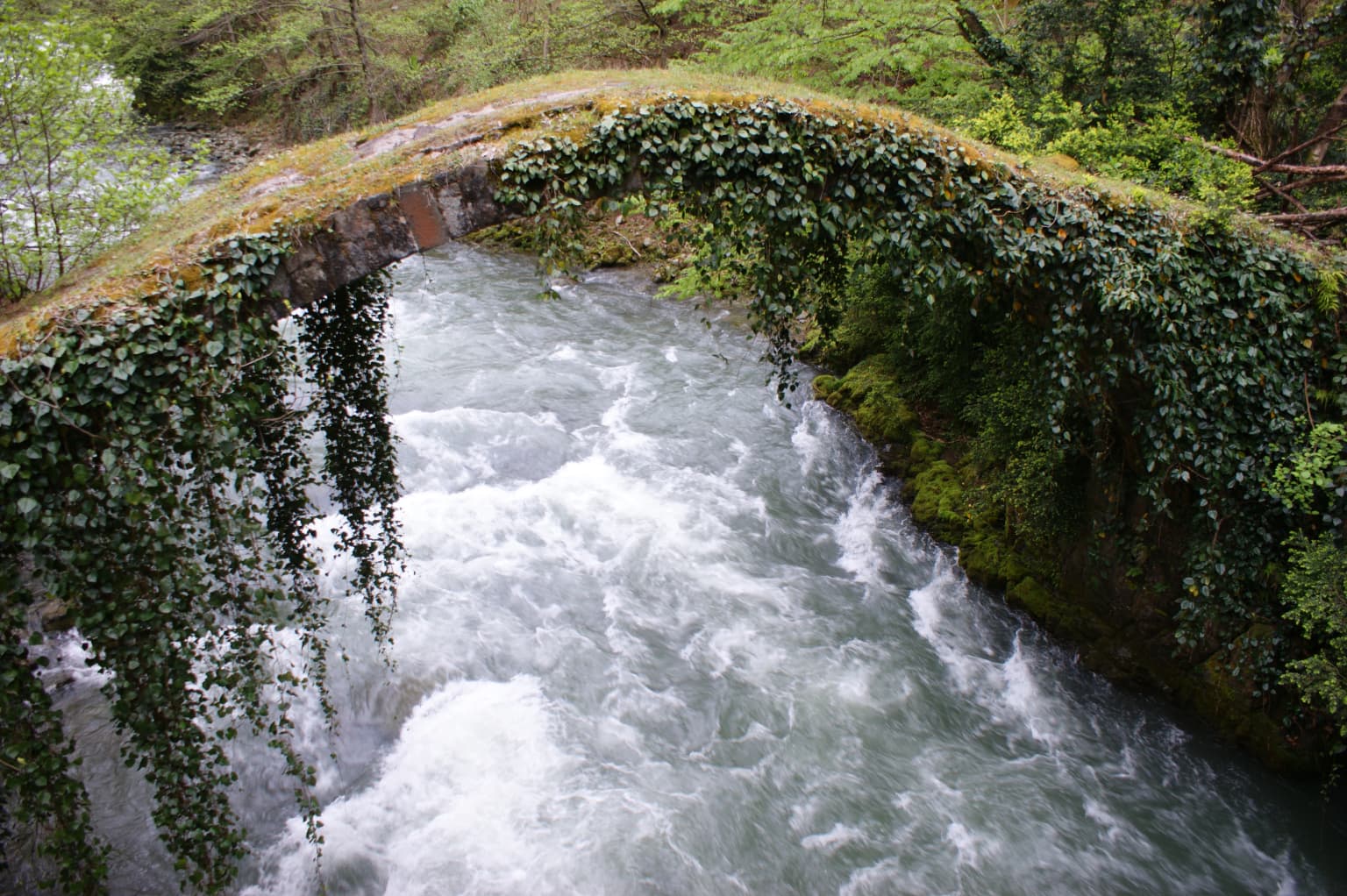
Kintrishi National Park is best known for preserving dense Colchic deciduous forests in a dramatic river gorge setting, one of the most ecologically intact examples of this once-widespread ecosystem. The park's signature species is the Colchican willow, a locally characteristic tree that defines the visual character of the riparian corridors. The combination of steep canyon terrain, old-growth forest, and the wild Kintrishi River creates a landscape that feels remote and primeval despite its proximity to Georgia's populated Black Sea coast. The presence of a medieval stone bridge and ancient archaeological sites adds historical depth to the natural landscape.

Old arched stone bridge covered in ivy spanning a fast-flowing river with green vegetation on the banks
Old arched stone bridge covered in ivy spanning the Kintrishi River in Georgia

Kintrishi National Park history and protected-area timeline

The Kintrishi area has been recognized for its ecological significance since the Soviet era, when the Kintrishi Strict Nature Reserve was established in 1959 to protect the unique Colchic forest communities and rare species of the region. This early designation reflected scientific understanding of the area's ecological distinctiveness and the need to preserve representative samples of Georgia's disappearing lowland and foothill forests. In 2007, the protected area was expanded and re-designated as Kintrishi National Park, providing a more flexible management framework that allowed for sustainable tourism development alongside core conservation objectives. The transition from strict nature reserve to national park reflected a growing recognition in Georgian conservation policy that many protected landscapes could support carefully managed visitor access without compromising their ecological integrity. Archaeological evidence of pre-Christian monuments in the area indicates that human communities have inhabited and traversed this canyon for millennia, with the medieval bridge over the Kintrishi River representing later periods of settlement and regional connectivity.

Kintrishi National Park landscape and geographic character

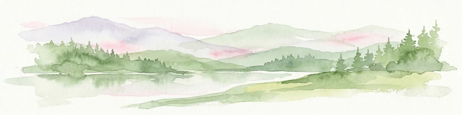
The physical landscape of Kintrishi National Park is defined by the steep-sided gorge of the Kintrishi River as it descends from the mesophilic forests of the Meskheti mountain foothills toward the coastal plain. The terrain features dramatic elevation changes over relatively short distances, with the river cutting through rocky channels, forming small waterfalls, and creating pools that harbor aquatic life. The canyon walls are cloaked in dense deciduous forest, predominantly beech, oak, and the park's signature Colchican willows, creating a claustrophobic green corridor that limits sunlight to the riverbed below. Rocky outcrops and cliff faces break the forest canopy in places, providing habitat for specialized plant communities and shelter for wildlife. The overall impression is of a wild, enclosed landscape where the sound of rushing water provides constant background ambience and the forest feels ancient and untouched.

Kintrishi National Park ecosystems, habitats, and plant life

Kintrishi National Park protects one of the finest remaining examples of Colchic forest ecosystem in Georgia, a biome characterized by humid, species-rich deciduous woodland that once covered vast stretches of the Colchis lowland region bordering the Black Sea. The park's namesake tree, the Colchican willow, forms distinctive riparian woodland along the river corridor, creating a visually characteristic landscape element that distinguishes this protected area from other Georgian forests. The combination of adequate moisture, mild winter temperatures, and varied topography supports a diverse understory including ferns, mosses, and numerous endemic plant species that have evolved in isolation within this humid refuge. The forest structure is multilayered, with canopy species, sub-canopy trees, shrubs, and ground cover creating complex habitat layers that support corresponding animal communities. The river itself maintains aquatic ecosystems dependent on cool, well-oxygenated water flowing through the canyon.

Kintrishi National Park wildlife and species highlights

The Colchic forest environment of Kintrishi supports a diversity of wildlife adapted to dense deciduous woodland and the river corridor's aquatic habitats. Birdlife includes species typical of Caucasian deciduous forests, while the canopy and understory provide breeding and foraging habitat for numerous songbird species. The river and its rocky sections support fish populations and provide drinking access for larger mammals that patrol the canyon corridor. The forest's structural complexity, with standing dead trees and fallen logs, creates habitat for invertebrates, amphibians, and small mammals that form the base of the food web. While specific species lists vary in the source material, the overall character of the wildlife community reflects the broader Colchic forest ecosystem, one of the biodiversity hotspots of the Caucasus region.

Kintrishi National Park conservation status and protection priorities

Kintrishi National Park represents an important node in Georgia's protected area network, preserving a landscape that exemplifies the Colchic forest biome now greatly diminished across its historic range. The dual designation of national park and strict nature reserve creates a zoned conservation approach that protects the most ecologically sensitive areas while allowing controlled public access to the broader landscape. The protection of Colchican willow communities is particularly significant, as these trees define a distinctive aspect of the region's ecological character that has been lost from much of the former Colchis forest zone. The park contributes to broader Caucasus biodiversity conservation by maintaining connectivity between coastal and mountain ecosystems, allowing species to migrate and adapt as climate conditions shift.

Kintrishi National Park cultural meaning and human context

The Kintrishi canyon has served as a travel corridor for centuries, as evidenced by the arched 12th-century stone bridge that crosses the river within the protected area. This medieval crossing represents the historical importance of river valleys as routes through Georgia's mountainous terrain, connecting the coastal lowlands with the interior highlands of Adjara and beyond. Archaeological excavations have revealed pre-Christian monuments in the area, indicating that this landscape held spiritual or ceremonial significance for earlier human communities. The combination of natural features and cultural heritage within a protected landscape creates a visitation experience that combines scenic beauty with historical depth, distinguishing Kintrishi from purely natural landscapes that lack such human history markers.

Top sights and standout views in Kintrishi National Park

Kintrishi National Park offers a compact but immersive experience of Colchic forest canyon landscapes that have largely vanished from the broader Black Sea region. The dramatic gorge environment, with its steep walls, rushing river, and dense forest canopy, creates a sense of wilderness within reach of Georgia's coastal population centers. The Colchican willows along the river provide a distinctive visual identity, while the 12th-century bridge adds historical atmosphere that enriches the natural landscape. The park's dual structure as both national park and strict nature reserve provides options for both casual exploration and more remote backcountry experiences.

Best time to visit Kintrishi National Park

The Kintrishi canyon is most comfortably visited during the warmer months from late spring through early autumn, when conditions are suitable for hiking and forest exploration. The summer months offer full leaf cover and active river flow, though the deep canyon can feel warm. Autumn brings color changes in the deciduous canopy and generally comfortable temperatures for walking. Winter access may be limited due to reduced facilities and cooler conditions in the mountain foothills, though the park's lower elevation relative to true alpine areas means conditions are less extreme than at higher Georgian protected areas.

Park location guide

Geography guide, regional context, and park location map for Kintrishi National Park

Kintrishi National Park park geography, regions, and map view in Georgia
Understand where Kintrishi National Park sits in Georgia through a broader geographic reading of the surrounding landscape, nearby location context, and its mapped position within the national park landscape.

How Kintrishi National Park fits into Georgia

Georgia is a transcontinental country spanning Eastern Europe and West Asia, situated in the Caucasus region along the Black Sea. It declared independence from the Soviet Union in 1991 and today functions as a unitary parliamentary republic with Tbilisi as its capital. The nation is notable for its distinctive Georgian language, Orthodox Christian traditions dating to the 4th century, and archaeological evidence of the world's earliest winemaking sites.

Wider geography shaping Kintrishi National Park in Georgia

Georgia occupies a strategic position at the crossroads of Eastern Europe and West Asia, bordered by Russia to the north and northeast, the Black Sea to the west, Turkey and Armenia to the south, and Azerbaijan to the southeast. The terrain is predominantly mountainous in the north with the Greater Caucasus range, transitioning to plains and valleys in the east. The country spans approximately 69,700 square kilometres.

Map view of Kintrishi National Park

Use this park location map to pinpoint Kintrishi National Park in Georgia, understand its exact geographic position, and read its mapped placement within the surrounding landscape more clearly.

Pigeon | © OpenStreetMap contributors

Location context for Kintrishi National Park

Adjara

Visualizing Kintrishi's Unique Habitats, Dramatic Canyon Terrain, and Protected-Area Environment

Kintrishi National Park Photos: Explore the Ancient Colchic Forest Landscapes and River Gorge Scenery
Browse photos of Kintrishi National Park to visually comprehend its unique Colchic forest ecosystems, dramatic river gorge, and protected mountain terrain. These images provide essential context for the park's distinct landscape character, showcasing signature Colchican willows, ancient deciduous woodlands, and the wild Kintrishi River environment critical to its conservation status.

Old arched stone bridge covered in ivy spanning a fast-flowing river with green vegetation on the banks

Park atlas

Explore Georgia's protected area network, comparing the regional geography and diverse conservation landscapes surrounding Kintrishi National Park.

Explore Parks Near Kintrishi National Park: Discover Other Protected Areas in Georgia's Meskheti Mountains
After exploring Kintrishi National Park, browse other national parks and protected areas across Georgia's western Caucasus region, identifying adjacent or similarly themed conservation landscapes. Compare their diverse river canyons, Colchic forests, and mountainous terrain to understand the broader regional spread of protected ecosystems and unique geographic features.
Watercolor illustration of a landscape with green hills, trees, and a body of water
National parkAdjara

Mtirala National Park: Protected Colchic Rainforest Landscape & Geographic Atlas

Explore Adjara's unique terrain and mapped protected boundaries.

Mtirala National Park, located in Georgia's Adjara region, is a protected national park renowned for its exceptionally high rainfall and ancient Colchic relict forests. This atlas-focused profile details the park's unique topography, its watershed between the Chakvistskali and Khoristskali rivers, and its significance as a vital ecosystem. Understand the geographic context of this protected landscape and its role in the broader Caucasus geography.

Area
281.26 km²
Established
2006
IUCN
II
Relief
Mixed relief
National parkAdjara

Machakhela National Park: Adjara's Colchic Forest Protected Landscape

Explore Georgia's unique Caucasus mountain geography and mapped park boundaries.

Machakhela National Park represents a crucial protected area in Georgia's Adjara region, safeguarding the integrity of ancient Colchic broadleaf forests. This park's landscape is characterized by the steep Machakhelistsqali River valley, carved into the lower Caucasus mountains, offering a distinct geographic profile for atlas exploration. Discover the park's specific terrain, mapped boundaries, and its ecological significance as a vital component of the regional natural heritage.

Area
130.7 km²
Established
2012
IUCN
II
Relief
Mixed relief
National parkGeorgia

Kolkheti National Park: Mapped Wetland Landscape & Protected Area in Georgia

Explore the peat bogs, coastal ecosystems, and bird migration routes.

Discover Kolkheti National Park, a key protected national park located in Georgia's western coastal region. This atlas entry focuses on the park's extensive wetland environments, including its significant peat bogs and Lake Paliastomi, highlighting its role as a critical migratory bird corridor and a unique natural landscape within the Black Sea region. Understand its geographic context and protected area boundaries.

Area
807.99 km²
Established
1998
IUCN
II
Visitors
13.7K annual
Watercolor illustration of a winding river through green hills with pink flowers in the foreground
National parkArtvin Province

Hatila Valley National Park: Dramatic V-Shaped Valley and Volcanic Terrain in Artvin Province

Explore protected landscape, waterfalls, and botanical diversity.

Hatila Valley National Park represents a significant protected area within Artvin Province, Turkey, notable for its exceptionally steep, V-shaped river valley. This national park features a striking volcanic landscape characterized by deep gorges, numerous waterfalls, and unique geomorphological structures. Its rich botanical diversity, with 769 documented plant species including many endemics, positions it as a key site for understanding protected landscapes and regional flora. The park's geographic setting at the eastern end of the Kaçkar Mountains provides context for its Mediterranean climate and varied terrain.

Area
169 km²
Established
1994
Relief
Mountain
Climate
Mediterranean
Watercolor painting showing mountains, trees, and a lake in soft green and blue tones
National parkArtvin Province

Karagöl-Sahara National Park: Mapped Highland Lake and Plateau Protected Area

Discover Artvin Province's unique landslide lake and alpine terrain.

Karagöl-Sahara National Park presents a compelling protected landscape in Artvin Province, Turkey, renowned for its dramatic landslide lake, Karagöl, and the expansive Sahara plateau. This national park provides a unique map of highland geography, featuring dense conifer forests that give way to alpine meadows at elevations around 1,800 meters. Examine the geological character, including active landslide zones and sedimentary formations, that shape this distinctive terrain and contribute to its protected ecological value within the Black Sea Region.

Area
32.51 km²
Established
1994
Relief
Mountain
Climate
Boreal
National parkGeorgia

Borjomi-Kharagauli National Park: Protected Landscape Atlas of Georgia's Lesser Caucasus

Explore its unique forests, wildlife, and mountain terrain.

Delve into Borjomi-Kharagauli National Park, a significant protected area in Georgia's Lesser Caucasus region. This national park is renowned for its extensive old-growth forests, including rare Colchian fragments, and a remarkable concentration of endemic species. The park's dramatic mountainous terrain, spanning over 1,000 square kilometers, offers a rich tapestry of landscapes from deep valleys to alpine meadows, providing critical habitat for large mammals and contributing significantly to the region's biodiversity. Explore its mapped boundaries and geographic context for a deeper understanding of this vital conservation landscape.

Area
1,093 km²
Established
1995
IUCN
II
Relief
Mountain
Watercolor painting of green and pink mountain ranges under a light sky background
National parkSamtskhe–Javakheti

Javakheti National Park: Protected Highland Landscape and Wetland Atlas

Explore the unique geography and mapped park boundaries of this Georgian protected area.

Delve into Javakheti National Park, a significant protected landscape located in Georgia's Samtskhe, Javakheti region. This page serves as an entry point for understanding the park's distinctive highland terrain, its remarkable chain of lakes and marshes, and its protected area status. Explore the geographic context of this national park, its role in wetland conservation, and its value for structured atlas-based discovery of natural landscapes.

Area
238.53 km²
Established
2011
IUCN
II
Relief
Mixed relief
National parkShirak Province

Lake Arpi National Park: High-Altitude Wetland Protected Landscape in Shirak Province

Mapped boundaries of an important South Caucasus conservation area.

Lake Arpi National Park offers a unique window into high-altitude wetland ecosystems on the Shirak and Javakheti plateau, located at roughly 2000 meters above sea level. Established as a national park in 2009, it protects critical habitats, including the central Lake Arpi, and serves as a vital sanctuary for numerous bird species. This protected area is distinguished by its alpine meadows, significant bird populations, and its distinct geographic setting within Armenia's northwestern region, providing rich context for atlas-based exploration of protected lands.

Area
250 km²
Established
2009
IUCN
II
Relief
Mountain

Common questions about visiting, size, designation, and location context for Kintrishi National Park

Kintrishi National Park FAQs for park facts, access, geography, and protected area context
Find quick answers about Kintrishi National Park, including protected-area facts, park geography, trail and visitor context, and how the park fits into its surrounding country and regional landscape.
MoriAtlas Explorer

Continue Your Protected Areas Search Across the Global Atlas

Deepen your exploration by continuing the structured search for national parks and protected areas worldwide. Utilize the comprehensive filtering capabilities to compare different conservation landscapes and refine your understanding of global park geography. Discover more about the distribution and characteristics of protected natural areas.

Global natural geography