Mori Atlas logo
National parkJavakheti National Park

Discover the mapped boundaries and unique geography of this Samtskhe–Javakheti protected area.

Javakheti National Park: Georgia's Protected Highland Wetland Landscape

Javakheti National Park offers a distinctive protected landscape within Georgia's Samtskhe–Javakheti region, characterized by a unique highland setting on a volcanic plateau. This national park is defined by an interconnected chain of lakes and expansive marshlands, forming critical wetland ecosystems. Its geographic focus on these water bodies and surrounding grasslands provides a unique context for atlas exploration, highlighting the park's role as a vital protected area within the broader regional geography and a key component of transboundary conservation efforts.

WetlandsLakesBirdwatchingHighland PlateauTransboundary Protected AreaMarshes
An illustration showing a grassy plain with cows grazing, mountains in the background, and a colorful sky with clouds

Javakheti National Park

National park

Park overview

Structured park overview, official facts, and landscape profile for Javakheti National Park

Javakheti National Park park facts, protected area profile, and essential visitor context
Review the core facts for Javakheti National Park, including designation, size, terrain, visitor scale, habitats, and operating context in one park-focused overview.

About Javakheti National Park

Javakheti National Park occupies a distinctive position among Georgia's protected areas as the nation's primary highland wetland conservation site. The park is located in the Samtskhe-Javakheti region, Georgia's southernmost territory, where the landscape transitions from the greater Caucasus foothills into the mountainous terrain that continues into Armenia and Turkey.

The protected area was established in 2011 following a development process involving the Georgian government in partnership with the World Wide Fund for Nature and with financial support from the German government. This collaborative origin reflects the park's role in broader regional conservation planning, particularly its function as part of a transboundary protected area network linking Georgia with Armenia's Lake Arpi National Park.

The park encompasses a complex of lakes and marshes that form the headwaters of several small rivers draining southward. These water bodies, including Khanchali Lake, Madata Lake, and the extensive Kartsakhi and Sulda marsh systems, represent Georgia's most important inland wetland habitats. The surrounding terrain consists of gently rolling grasslands on volcanic-derived soils, creating a relatively open landscape quite different from the forested mountain valleys found elsewhere in Georgia.

Management of the park operates within the framework of the Javakheti Protected Areas, a comprehensive conservation network that includes multiple managed reserves protecting individual components of the wetland system. The broader protected areas complex extends the conservation framework beyond the core national park to include additional lake reserves added in 2019.

Quick facts and research context for Javakheti National Park

Javakheti National Park covers approximately 238 square kilometers in the Ninotsminda Municipality of southern Georgia. The protected area was established in 2011 under the management of Georgia's Agency of Protected Areas. The park forms part of the larger Javakheti Protected Areas network, which includes several managed reserves protecting individual lakes and marsh systems such as Kartsakhi, Sulda, Khanchali, Bugdasheni, and Madatapa. The area lies on a high volcanic plateau at elevations typical of the southern Georgian highlands, creating a landscape distinct from Georgia's more famous mountain forests and alpine zones.

Park context

Deeper park guide and search-rich context for Javakheti National Park

Javakheti National Park history, landscape, wildlife, and travel context
Explore Javakheti National Park through its history, landscape character, ecosystems, wildlife, conservation priorities, cultural context, and seasonal travel timing in a structured park guide built for atlas discovery and search intent.

Why Javakheti National Park stands out

Javakheti National Park is best known for its exceptional wetland and lake systems that serve as critical habitat for diverse birdlife. The chain of lakes and marshes provides refuge for significant populations of waterfowl including velvet scoter, ruddy shelduck, ferruginous duck, and various pelican species. The marshes and grasslands support breeding populations of corn crake, storks, and an array of waders. The park also protects two notable bird species: the crimson-winged finch and Radde's accentor, both associated with the highland rocky and shrubland environments surrounding the lakes.

Golden-brown grasslands stretch toward a mountain under a blue sky with scattered clouds. A herd of animals is visible in the midground.
Grasslands and mountain landscape in Javakheti National Park

Javakheti National Park history and protected-area timeline

Javakheti National Park was established in 2011 through the initiative of Georgia's Agency of Protected Areas, representing a relatively recent addition to the country's protected area network. The creation of the park was driven by recognition of the region's exceptional ecological value, particularly its significance as a major wetland complex supporting nationally and internationally important bird populations.

The development of the national park was supported by the German government through conservation funding programs, and the project was implemented with technical assistance from the World Wide Fund for Nature. This international cooperation reflected both the ecological significance of the area and its position within broader regional conservation planning.

From its inception, the park was conceived as part of an integrated conservation approach covering the entire Javakheti wetland system. The national park designation provided core protection for the most significant areas, while the surrounding managed reserves protect additional lakes and marshes that form ecological and hydrological connections to the main protected area. This layered approach was expanded in 2019 with the addition of several new managed reserves protecting additional lake systems within the broader Javakheti area.

Javakheti National Park landscape and geographic character

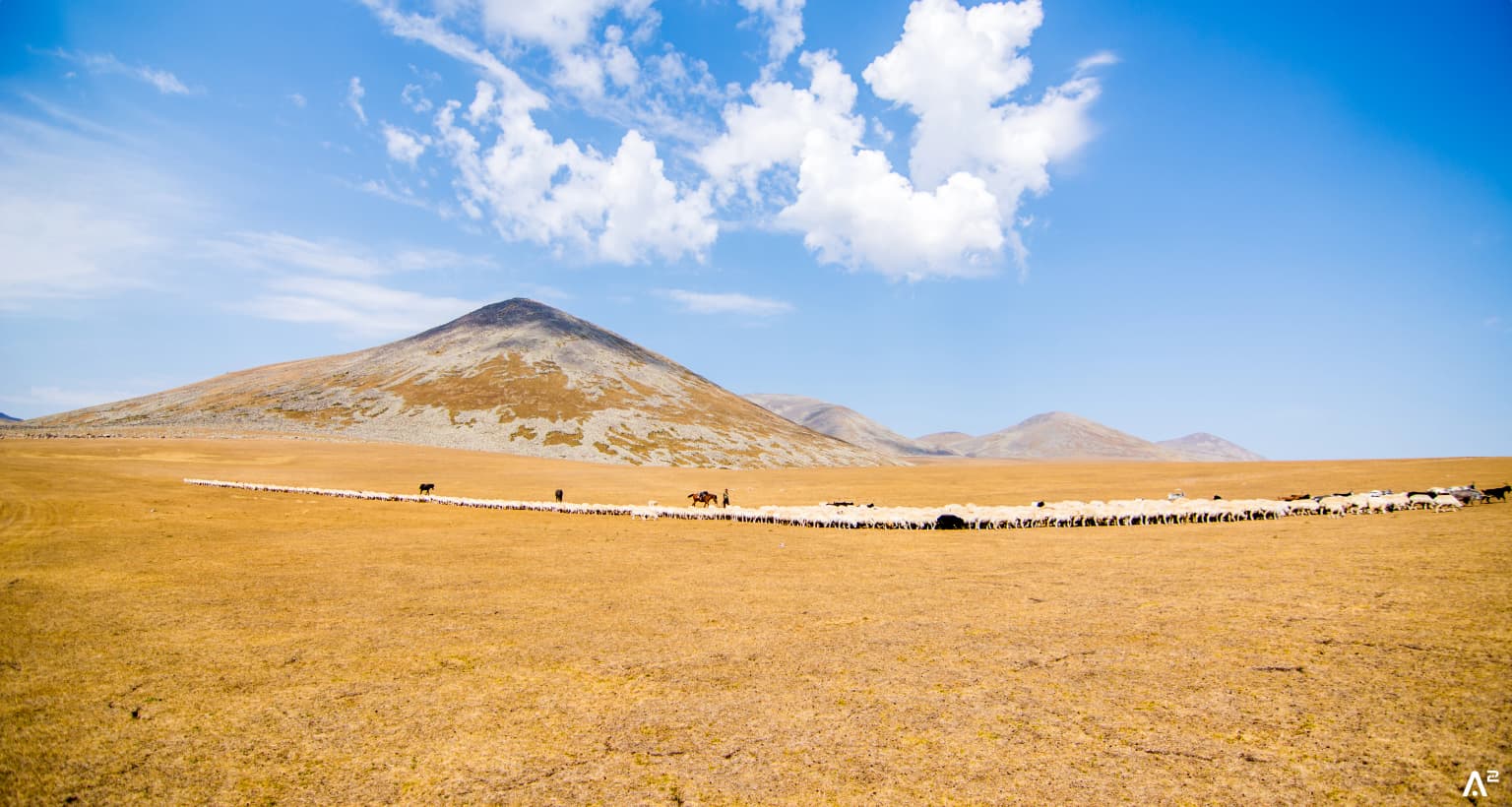
The landscape of Javakheti National Park is defined by its highland setting on the Samtskhe-Javakheti volcanic plateau. The terrain consists of gently undulating hills and rolling slopes at elevations between 1,500 and 2,000 meters above sea level. The underlying volcanic geology gives the landscape its characteristic rounded forms and fertile soils that support the extensive grassland cover.

The park's most distinctive feature is its chain of lakes and associated marshlands. These water bodies occupy depressions in the volcanic terrain, forming an interconnected wetland complex. Khanchali Lake and Madata Lake are the largest open-water areas, while the Kartsakhi and Sulda marshes represent extensive wetland zones where emergent vegetation dominates. The lakes have relatively shallow depths and muddy bottoms, characteristics typical of highland lake systems in volcanic regions.

The surrounding landscape consists of grasslandsteppe vegetation that covers the hillslopes and valley floors between the water bodies. This relatively open terrain lacks the dense forest cover found in much of Georgia, giving the area a distinctive highland character quite different from the country's more famous forested mountain landscapes.

Javakheti National Park ecosystems, habitats, and plant life

The ecological significance of Javakheti National Park centers on its exceptional wetland habitats. The lakes, marshes, and surrounding grasslands form a complex ecosystem that supports remarkable biodiversity, particularly for waterbirds and migratory species. The wetlands represent some of the most important bird habitats in the Caucasus region, serving as breeding grounds, staging areas, and wintering sites for numerous species.

The lake and marsh environments support diverse aquatic plant communities and provide critical habitat for invertebrate populations that form the base of the food web supporting waterbird populations. The surrounding grasslands, while less celebrated than the wetlands, provide important habitat for steppe-associated species and contribute to the overall ecological diversity of the protected area.

The highland setting at elevations around 1,500 to 2,000 meters creates a distinctive ecological character. The climate is more continental than most of Georgia, with colder winters and relatively warm summers. These conditions support plant and animal communities adapted to higher-elevation environments, including species more typical of mountain grasslands and rocky alpine zones.

Javakheti National Park wildlife and species highlights

Javakheti National Park is renowned for its birdlife, with the wetland complex supporting exceptional diversity and significant populations of waterfowl and other water-associated species. The lakes and marshes provide crucial habitat for diving ducks including velvet scoter and ferruginous duck, along with surface-feeding ducks such as the ruddy shelduck. Various species of pelicans breed and forage in the wetland areas, representing some of the most southerly breeding populations of these large waterbirds in the region.

The marshes and lake margins support breeding populations of corn crake in the dense emergent vegetation, while waders including sandpipers, terns, and turnstones feed along muddy shorelines and shallow water areas. Storks are regular visitors and breeders, utilizing the wetlands for foraging. The surrounding grasslands support populations of birds of prey including hawks hunting over the open terrain.

Two species are particularly notable for their association with the park's highland rocky and shrubland habitats: the crimson-winged finch and Radde's accentor. These species are characteristic of the mountainous regions of the eastern Mediterranean and Caucasus, and their presence within the park reflects the diverse habitat mosaic that extends beyond the wetland core.

Javakheti National Park conservation status and protection priorities

Javakheti National Park represents Georgia's primary designation for protecting highland wetland ecosystems of national and international significance. The protected area was established specifically to conserve the natural state of the lake and marsh complexes that represent some of the country's most important inland wetlands.

The transboundary dimension of the park's conservation framework is particularly significant. Through its connection with Lake Arpi National Park in Armenia, the protected area forms part of a cross-border conservation network that allows for the protection of migratory species and ecological processes that do not respect international boundaries. This cooperation enhances the effectiveness of conservation efforts for species that depend on wetland habitats across both countries.

Beyond direct habitat protection, the park's management framework addresses broader environmental objectives including sustainable water resource management, support for traditional livestock farming practices, and development of local product marketing opportunities. This integrated approach recognizes the connections between conservation outcomes and the wellbeing of local communities who depend on the landscape's resources.

Javakheti National Park cultural meaning and human context

The Javakheti region has a distinctive cultural character shaped by its highland setting and historical development. The area has historically supported pastoral and agricultural communities engaged in livestock farming, particularly sheep and cattle husbandry on the grasslands surrounding the lakes. These traditional land use practices have influenced the landscape over centuries, maintaining the open grassland character that remains a defining feature of the area.

The park encompasses territory within both the Akhalkalaki and Ninotsminda municipalities, with the nearest towns of Akhalkalaki and Ninotsminda serving as local population centers. The communities in this region maintain cultural connections to the broader Javakheti highlands, an area with distinct historical and ethnographic characteristics within Georgia.

Top sights and standout views in Javakheti National Park

Javakheti National Park offers visitors access to one of Georgia's most distinctive landscapes—the highland wetland complex of the southern volcanic plateau. The chain of lakes and marshes provides exceptional opportunities for birdwatching, with diverse waterfowl and wetland birds present throughout the year. The relatively open terrain and gentle topography make the park accessible for exploration, with walking paths around the lake shores and through the marsh areas. The transboundary connection with Armenia's Lake Arpi National Park creates a unique conservation area spanning two countries. The park's relatively recent establishment and ongoing development represent an important investment in Georgia's protected area network and wetland conservation capacity.

Best time to visit Javakheti National Park

The optimal season for visiting Javakheti National Park depends on interests and priorities. Spring and early summer bring the breeding season, when waterfowl are most actively using the wetlands and bird activity is highest. Migratory species pass through during both spring and autumn, creating excellent birdwatching opportunities. Summer offers the warmest conditions for exploring the park's trails and enjoying the open landscape, though this is also the period of highest visitor activity. Winter reveals a different character as the lakes may freeze and the landscape takes on a stark highland appearance, though wildlife viewing opportunities are reduced. The park can be visited year-round, though spring through autumn offers the most diverse experiences.

Park location guide

Geography guide, regional context, and park location map for Javakheti National Park

Javakheti National Park park geography, regions, and map view in Georgia
Understand where Javakheti National Park sits in Georgia through a broader geographic reading of the surrounding landscape, nearby location context, and its mapped position within the national park landscape.

How Javakheti National Park fits into Georgia

Georgia is a transcontinental country spanning Eastern Europe and West Asia, situated in the Caucasus region along the Black Sea. It declared independence from the Soviet Union in 1991 and today functions as a unitary parliamentary republic with Tbilisi as its capital. The nation is notable for its distinctive Georgian language, Orthodox Christian traditions dating to the 4th century, and archaeological evidence of the world's earliest winemaking sites.

Wider geography shaping Javakheti National Park in Georgia

Georgia occupies a strategic position at the crossroads of Eastern Europe and West Asia, bordered by Russia to the north and northeast, the Black Sea to the west, Turkey and Armenia to the south, and Azerbaijan to the southeast. The terrain is predominantly mountainous in the north with the Greater Caucasus range, transitioning to plains and valleys in the east. The country spans approximately 69,700 square kilometres.

Map view of Javakheti National Park

Use this park location map to pinpoint Javakheti National Park in Georgia, understand its exact geographic position, and read its mapped placement within the surrounding landscape more clearly.

Pigeon | © OpenStreetMap contributors

Location context for Javakheti National Park

Ninotsminda MunicipalitySamtskhe–Javakheti

Visualizing Georgia's Volcanic Plateau, Diverse Wetland Habitats, and Mountain Grasslands

Javakheti National Park Photos: Explore Highland Lake Landscapes and Wetland Scenery
Browse an immersive visual gallery of Javakheti National Park to understand its distinctive highland terrain, expansive wetland ecosystems, and rich biodiversity across the Georgian volcanic plateau. These landscape images showcase the park's interconnected lakes, vital marshlands, and rolling mountain grasslands, offering critical insight into its protected-area character and unique conservation environment.

Golden-brown grasslands stretch toward a mountain under a blue sky with scattered clouds. A herd of animals is visible in the midground.

Grassy field with grazing cattle, distant snow-capped mountains, and partly cloudy sky

Park atlas

Explore Neighboring Protected Areas and Wetland Systems Across Samtskhe–Javakheti Region

Discover Other National Parks Near Javakheti National Park, Georgia's Highland Wetlands
Continue exploring national parks and protected areas within Georgia's Samtskhe–Javakheti region and its transboundary landscapes, extending your discovery from Javakheti National Park. Trace the unique highland wetlands, volcanic plateaus, and extensive grasslands found in this crucial conservation corridor by comparing their distinct geographic features.
National parkShirak Province

Lake Arpi National Park: High-Altitude Wetland Protected Landscape in Shirak Province

Mapped boundaries of an important South Caucasus conservation area.

Lake Arpi National Park offers a unique window into high-altitude wetland ecosystems on the Shirak and Javakheti plateau, located at roughly 2000 meters above sea level. Established as a national park in 2009, it protects critical habitats, including the central Lake Arpi, and serves as a vital sanctuary for numerous bird species. This protected area is distinguished by its alpine meadows, significant bird populations, and its distinct geographic setting within Armenia's northwestern region, providing rich context for atlas-based exploration of protected lands.

Area
250 km²
Established
2009
IUCN
II
Relief
Mountain
National parkGeorgia

Borjomi-Kharagauli National Park: Protected Landscape Atlas of Georgia's Lesser Caucasus

Explore its unique forests, wildlife, and mountain terrain.

Delve into Borjomi-Kharagauli National Park, a significant protected area in Georgia's Lesser Caucasus region. This national park is renowned for its extensive old-growth forests, including rare Colchian fragments, and a remarkable concentration of endemic species. The park's dramatic mountainous terrain, spanning over 1,000 square kilometers, offers a rich tapestry of landscapes from deep valleys to alpine meadows, providing critical habitat for large mammals and contributing significantly to the region's biodiversity. Explore its mapped boundaries and geographic context for a deeper understanding of this vital conservation landscape.

Area
1,093 km²
Established
1995
IUCN
II
Relief
Mountain
Watercolor painting showing mountains, trees, and a lake in soft green and blue tones
National parkArtvin Province

Karagöl-Sahara National Park: Mapped Highland Lake and Plateau Protected Area

Discover Artvin Province's unique landslide lake and alpine terrain.

Karagöl-Sahara National Park presents a compelling protected landscape in Artvin Province, Turkey, renowned for its dramatic landslide lake, Karagöl, and the expansive Sahara plateau. This national park provides a unique map of highland geography, featuring dense conifer forests that give way to alpine meadows at elevations around 1,800 meters. Examine the geological character, including active landslide zones and sedimentary formations, that shape this distinctive terrain and contribute to its protected ecological value within the Black Sea Region.

Area
32.51 km²
Established
1994
Relief
Mountain
Climate
Boreal
Watercolor illustration of a mountainous landscape with green forests, rolling hills, and distant mountains under a light sky
National parkGeorgia

Algeti National Park: Explore Georgia's Protected Coniferous Forest Landscape

Mountain terrain, protected forests, and regional geography.

Algeti National Park, located in Georgia's Kvemo Kartli region, serves as a critical protected area preserving the easternmost populations of Caucasian Spruce and Nordmann Fir. This national park features a dramatic mountainous landscape within the Trialeti Range, characterized by deeply incised valleys, flowing rivers, and extensive old-growth forest ecosystems. Users can explore the park's geographic context, mapped boundaries, and the ecological significance of its unique coniferous and mixed forests, contributing to a broader understanding of protected lands in the Caucasus.

Area
68.22 km²
Established
2007
IUCN
II
Visitors
8K annual
National parkTurkey

Sarıkamış-Allahuekber Mountains National Park: High-Altitude Protected Forest and WWI Memorial Landscape in Turkey

Explore the distinct protected terrain and historical geography of Turkey's eastern highlands.

Sarıkamış-Allahuekber Mountains National Park offers a unique exploration of high-altitude protected lands in Turkey. This national park is characterized by its remarkable pure Caucasian pine forests that thrive at elevations typically above the tree line, showcasing a rare alpine ecosystem. The park's rugged mountain terrain, marked by significant historical sites from the Battle of Sarikamish, provides a profound connection between natural landscape and human history within its mapped boundaries. Discover the geographic setting and protected status of this distinctive area.

Area
225.19 km²
Established
2004
Relief
Mountain
Scope
Terrestrial
Watercolor illustration of a landscape with rolling hills, forests, and a winding river.
National parkAdjara

Kintrishi National Park: Protected Colchic Forest Canyon Landscape in Adjara

Explore the mapped geographic boundaries of this unique Georgian national park.

Kintrishi National Park, located in Georgia's Adjara region, is a protected landscape renowned for its exceptionally intact Colchic deciduous forests within a steep river gorge. This area showcases dense woodland, dramatic terrain, and the unique Colchican willow species, offering rich geographic context. As a key protected area, Kintrishi National Park provides a valuable focus for atlas-based exploration of southwestern Georgia's natural heritage.

Area
186.84 km²
Established
2007
IUCN
II
Scope
Terrestrial
Watercolor illustration of a landscape with green hills, trees, and a body of water
National parkAdjara

Mtirala National Park: Protected Colchic Rainforest Landscape & Geographic Atlas

Explore Adjara's unique terrain and mapped protected boundaries.

Mtirala National Park, located in Georgia's Adjara region, is a protected national park renowned for its exceptionally high rainfall and ancient Colchic relict forests. This atlas-focused profile details the park's unique topography, its watershed between the Chakvistskali and Khoristskali rivers, and its significance as a vital ecosystem. Understand the geographic context of this protected landscape and its role in the broader Caucasus geography.

Area
281.26 km²
Established
2006
IUCN
II
Relief
Mixed relief
Watercolor illustration of a winding river through green hills with pink flowers in the foreground
National parkArtvin Province

Hatila Valley National Park: Dramatic V-Shaped Valley and Volcanic Terrain in Artvin Province

Explore protected landscape, waterfalls, and botanical diversity.

Hatila Valley National Park represents a significant protected area within Artvin Province, Turkey, notable for its exceptionally steep, V-shaped river valley. This national park features a striking volcanic landscape characterized by deep gorges, numerous waterfalls, and unique geomorphological structures. Its rich botanical diversity, with 769 documented plant species including many endemics, positions it as a key site for understanding protected landscapes and regional flora. The park's geographic setting at the eastern end of the Kaçkar Mountains provides context for its Mediterranean climate and varied terrain.

Area
169 km²
Established
1994
Relief
Mountain
Climate
Mediterranean

Common questions about visiting, size, designation, and location context for Javakheti National Park

Javakheti National Park FAQs for park facts, access, geography, and protected area context
Find quick answers about Javakheti National Park, including protected-area facts, park geography, trail and visitor context, and how the park fits into its surrounding country and regional landscape.
MoriAtlas Explorer

Continue Your Protected Areas Search Across the Global Atlas

Deepen your exploration by continuing the structured search for national parks and protected areas worldwide. Utilize the comprehensive filtering capabilities to compare different conservation landscapes and refine your understanding of global park geography. Discover more about the distribution and characteristics of protected natural areas.

Global natural geography