
Lakes
Park geography
Detailed analysis of terrain, regional landscape features, and park boundaries
Kejimkujik National Park: Comprehensive Geographic Profile and Mapped Boundaries
Review the geographic dimensions and physical characteristics of Kejimkujik National Park, situated in Nova Scotia, Canada. This structured profile maps the park area, elevation range, and diverse natural features, ranging from inland lake systems to coastal marine environments.
Canada's only dual-designation national park and national historic site protecting Mi'kmaq cultural landscape and Acadian forest wilderness
Kejimkujik National Park
Kejimkujik National Park is a uniquely designated protected area in southwest Nova Scotia, Canada, holding the distinction of being Canada's only heritage site with dual status as both a national park and a national historic site. The park encompasses 404 square kilometres across two distinct land areas: a large inland portion that coincides with the Kejimkujik National Historic Site, and the Kejimkujik National Park Seaside along the Atlantic coast. This landscape has been a significant Mi'kmaq cultural territory for millennia, with ancient canoe routes connecting the Bay of Fundy to the Atlantic shore. The park is named after Kejimikujik Lake, the second largest freshwater lake in mainland Nova Scotia, and protects vast tracts of Acadian forest along with one of the most significant concentrations of Mi'kmaq petroglyphs in Canada. The inland portion has been designated a dark-sky preserve by the Royal Astronomical Society of Canada, offering exceptional night sky viewing opportunities in southern Canada.
- Location
- Canada
- Park type
- National park
- Established
- 1967
- Area
- 404 km²
- Highest point
- 180 m
Location overview
Analyzing regional placement and coastal marine designations in Canada
Mapping the Geography of Kejimkujik National Park in Nova Scotia
Kejimkujik National Park is situated within the regional territory of Nova Scotia, Canada. Records indicate the protected area holds both coastal and marine geographic designations.
- Countries
- Canada
- Regions
- Nova Scotia
- Primary location
- Nova Scotia
- Geographic setting
- Coastal · Marine
Boundary and coordinates
Mapped spatial footprint across a 404 square kilometer conservation area
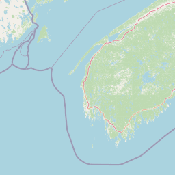
Kejimkujik National Park Boundary Map and Spatial Limits
Interactive boundary outlines establish the spatial context and geographic extent of the park. Accompanying dataset metrics cover calculated area, perimeter, and regional coordinate spans.
- Boundary area
- 381.4 km²
- Boundary perimeter
- 80.8 km
- Northernmost point
- 44.4772° N
- Southernmost point
- 44.2645° N
- Easternmost point
- 65.1506° W
- Westernmost point
- 65.451° W
- Geographic centre
- 44.3718° N, 65.2997° W
- North–south span
- 23.6 km
- East–west span
- 23.9 km
Elevation and terrain
Upland topography ranging from sea level to 180 meters
Kejimkujik National Park Terrain and Elevation Profile
Recorded elevation data outlines a vertical range spanning from zero to 180 meters across the upland terrain. Associated feature records detail lakes, islands, streams, and wetlands located within the protected boundary.
- Minimum elevation
- 0 m
- Maximum elevation
- 180 m
- Highest point
- 180 m
Selected named natural features
Lakes
Poplar Lake
Bays
Fairy Bay
Bays
Mill Bay
Islands
Mink Island
Islands
Hog Island
Environmental setting
Temperate upland relief, major water systems, and forest classifications
Kejimkujik National Park Environmental Classifications and Physical Setting
Recorded landscape features, habitat types, and climatic zones provide complementary frameworks for reading the physical setting of Kejimkujik National Park. Stored environmental categories connect directly to corresponding protected area destinations across the regional atlas.
- Relief
- Upland
- Climate
- Temperate
- Water
- Major water bodies
- Forest cover
- Mostly forested
- Seasonality
- Strongly seasonal
Landscape features
Forest · Wetland · Lakes · Rivers · Waterfalls · Coast · Beach · Hills · Valleys
Habitat types
Temperate broadleaf forest · Temperate coniferous forest · Wetland · Riverine habitat · Lacustrine habitat · Coastal habitat · Marine habitat
Park atlas
Map and compare diverse protected landscapes, coastal ecosystems, and forest reserves across Nova Scotia, expanding beyond Kejimkujik National Park.
Discover Other National Parks and Protected Areas Surrounding Kejimkujik National Park
Browse other national parks and diverse protected areas across Nova Scotia, tracing conservation landscapes near Kejimkujik National Park's unique inland and coastal territories. Compare these distinct park geographies to gain deeper insights into regional ecosystems, their protected status, and the broader natural heritage of the Canadian Maritimes.
Wildlife reserveNova Scotia
48 km away#1 closest
South

Zugvogelschutzgebiet Port Hebert: Coastal Protected Landscapes of Nova Scotia
Wildlife reserve and intertidal wetland geography
Spanning the shallow reaches of Port L'Hebert, this wildlife reserve serves as a foundational element of the South Shore protected area network. The sanctuary is defined by its wide tidal range, which uncovers extensive sand and mudflats to provide essential feeding grounds for migratory geese and ducks. This site offers deep insight into the coastal geography and wetland preservation status of Nova Scotia's rugged Atlantic fringe.
- Area
- 3.46 km²
- Established
- 1941
- IUCN
- Ia
Wildlife reserveNova Scotia
51 km away#2 closest
South
Zugvogelschutzgebiet Sable River Wildlife Reserve and Nova Scotia Coastal Geography
Protected estuarine sanctuary and waterfowl habitat
Spanning the sheltered waters of a river estuary, Zugvogelschutzgebiet Sable River acts as a essential component of the coastal conservation landscape in Nova Scotia. This protected wildlife reserve remains a vital staging area for migratory species, defined by its tidal salt marshes and open aquatic terrain which function in coordination with neighboring Atlantic sanctuary sites.
- Area
- 3.13 km²
- Established
- 1941
- IUCN
- Ia
Wildlife reserveNova Scotia
51 km away#3 closest
South
Haley Lake Migratory Bird Sanctuary: Protected Wildlife Reserve in Nova Scotia
Freshwater avian sanctuary and coastal nesting habitat
Haley Lake Migratory Bird Sanctuary provides a crucial freshwater refuge on the southwestern coast of Nova Scotia. This wildlife reserve features a unique lakeside environment that supports large gatherings of migratory waterfowl and a historic great blue heron breeding colony, situated between the brackish tidal flats of the surrounding estuarine landscape.
- Area
- 0.95 km²
- Established
- 1980
- IUCN
- Ia
- Relief
- Lowland
Wildlife reserveNova Scotia
86 km away#4 closest
Northeast
Kentville Migratory Bird Sanctuary: A Protected Wetland Reserve in the Cornwallis River Valley
Mapped riparian ecosystems and migratory bird habitats in Nova Scotia.
Discover the unique geography of the Kentville Migratory Bird Sanctuary, a compact wildlife reserve in Nova Scotia. This protected area features a blend of river channels, open fields, and forest mosaic that serves as a seasonal sanctuary for waterfowl. Learn about the riparian terrain that defines this critical node in the broader Atlantic flyway network.
- Area
- 5.06 km²
- Established
- 1939
- Relief
- Lowland
- Scope
- Terrestrial
Wildlife reserveNova Scotia
About 89 km away#5 closest
North
Île Haute Wildlife Reserve: Mapped Volcanic Geography and Coastal Protected Terrain
Bay of Fundy protected area, Nova Scotia
Rising abruptly from the Bay of Fundy, Île Haute features a steep, isolated plateau encircled by 100-meter basalt cliffs. This wildlife reserve showcases Jurassic volcanic geology and provides essential habitat for migratory seabirds and marine mammals. Gain insights into the island's unique coastal geography and its role as a protected natural sanctuary in Atlantic Canada.
- Area
- 0.8 km²
- Established
- 2025
- Relief
- Upland
- Scope
- Mixed
Wildlife reserveNova Scotia
About 108 km away#6 closest
Northeast
Boot Island National Wildlife Area: Mapping Coastal Conservation in Nova Scotia
Protecting intertidal mudflats and migratory bird habitats
Located in the Southern Bight of the Minas Basin, Boot Island National Wildlife Area serves as a key protected refuge within the Bay of Fundy. This reserve safeguards essential coastal and marshland habitats that support migratory bird populations, offering a focused look at how specific island geography functions within a larger, dynamic estuarine wetland system.
- Area
- 1.07 km²
- Established
- 1979
- IUCN
- Ia
- Relief
- Lowland
National parkNew Brunswick
118 km away#7 closest
North
Fundy National Park: New Brunswick National Park Atlas and Geographic Exploration
Mapped protected landscape and regional park context.
Fundy National Park represents a vital protected area, offering rich geographic discovery within New Brunswick, Canada. This national park detail provides context for its mapped boundaries and landscape, supporting atlas-based exploration of its regional significance. Understand Fundy National Park's protected status and its contribution to the mapped natural terrain of eastern Canada.
- Area
- 207 km²
- Established
- 1948
- IUCN
- II
- Visitors
- 303.6K annual
Wildlife reserveNew Brunswick
About 143 km away#8 closest
North
Réserve nationale de faune de Shepody: Geographic Overview of a New Brunswick Wildlife Reserve
Coastal wetlands and protected intertidal geography
Located along the Bay of Fundy, Réserve nationale de faune de Shepody represents an essential network of salt marshes and freshwater habitats. This mapping analysis traces the intersection of tidal dynamics, riverine estuaries, and ancient sandstone formations that define this critical protected area in New Brunswick.
- Area
- 10.69 km²
- Established
- 1980
- IUCN
- IV
- Relief
- Lowland
MoriAtlas Explorer
Continue Exploring Kejimkujik National Park's Geographic and Protected Landscape Detail
Dive deeper into the specifics of Kejimkujik National Park for a comprehensive understanding of its protected landscape and geographic setting. Examining its mapped features and regional context on MoriAtlas allows for detailed analysis and appreciation of its natural terrain. Continue your exploration to grasp the full extent of this Nova Scotia national park's atlas significance.
Browse next
Global natural geography
Explore related park routes
Explore MoriAtlas Global ParksBrowse All MoriAtlas ParksGlobal Park Map DiscoveryMoriAtlas: Browse All CountriesBrowse All MoriAtlas ContinentsNational Park Environment AtlasGrand Canyon National Park AtlasYellowstone National Park AtlasYosemite National Park Atlas and GeographySerengeti National Park AtlasGalápagos National Park Protected LandscapeBanff National Park Geography and AtlasKruger National Park Atlas EntryUluṟu-Kata Tjuṯa National Park AtlasExplore Uluru-Kata Tjuta National Park GeographyPlitvice Lakes National Park AtlasFiordland National Park Protected LandscapeGreat Smoky Mountains National Park AtlasAfghanistan National Parks and Protected AreasAlbania National Parks and Protected AreasAlgeria National Parks and Protected AreasAmerican Samoa National Parks and Protected AreasAndorra National Parks and Protected AreasAngola National Parks and Protected AreasAntarctica National Parks and Protected AreasAntigua and Barbuda Park List