Mori Atlas logo
Wildlife reserveKolleru Bird Sanctuary

Understanding the basin geography, reedbed distribution, and wetland boundaries of Andhra Pradesh

Kolleru Bird Sanctuary Wildlife Reserve: Geographic Atlas and Protected Wetland Map Context

Kolleru Bird Sanctuary serves as a vital freshwater basin located between the Krishna and Godavari river deltas in Andhra Pradesh. This wildlife reserve protects a mosaic of open water, floating aquatic vegetation, and dense Phragmites reedbeds. The sanctuary geography fluctuates seasonally, reflecting the dynamic water cycles that define this significant Ramsar wetland habitat within the coastal plains of South India.

freshwater wetlandbirdwatchingwaterbirdsRamsar siteprotected wetlandfreshwater lake

Kolleru Bird Sanctuary

Wildlife reserve

Park overview

Structured park overview, official facts, and landscape profile for Kolleru Bird Sanctuary

Kolleru Bird Sanctuary park facts, protected area profile, and essential visitor context

Review the core facts for Kolleru Bird Sanctuary, including designation, size, terrain, visitor scale, habitats, and operating context in one park-focused overview.

About Kolleru Bird Sanctuary

Kolleru Bird Sanctuary is centered on one of the largest natural freshwater lakes in coastal Andhra Pradesh, occupying a shallow depression between the two great deltaic river systems of southern India, the Krishna to the south and the Godavari to the north. This geographic position gives the sanctuary a distinctive hydrological and ecological character, shaped by seasonal monsoon inflows, deltaic silt, and a gently undulating basin that retains water for much of the year.

As a protected area, the sanctuary plays a central role in safeguarding habitat for waterbirds and a range of other wetland-dependent species. Its proximity to the coast and its placement between two major river deltas means that the lake functions as both a productive feeding ground and an important stopover point within broader flyway networks. The combination of open water, reedbeds, floating vegetation, and fringing margins creates a mosaic that supports breeding, wintering, and passage birds in unusually high numbers.

The sanctuary is also significant in human and cultural terms. Local fishing communities have long-standing connections with the lake and its resources, and the surrounding landscape carries a depth of rural and traditional ecological knowledge. Recognizing the sanctuary within the context of these pressures and traditions helps explain why its formal protection matters both for biodiversity and for the long-term integrity of one of Andhra Pradesh's most important wetland systems.

Quick facts and research context for Kolleru Bird Sanctuary

Kolleru Bird Sanctuary lies in the Eluru district of Andhra Pradesh, between the Krishna and Godavari river deltas, roughly 10 to 25 kilometers from the city of Eluru. It was established in November 1999 under India's Wildlife Protection Act of 1972 and is administered by the Andhra Pradesh Forest Department. The protected area falls within the broader Kolleru Lake wetland, which was designated a Ramsar site of international importance in 2002, highlighting its value as one of India's significant freshwater wetland complexes.

Protection and recognition

Documented terrestrial protection scope, establishment year, and management records

Kolleru Bird Sanctuary Protection Status and Designation History

Kolleru Bird Sanctuary maintains a documented terrestrial protection status established in 2002. Structured conservation records outline the official designation history and management scope.

Protection details

Protection scope
Terrestrial
Designated year
2002
Transboundary protection
No
Park context

Deeper park guide and search-rich context for Kolleru Bird Sanctuary

Kolleru Bird Sanctuary history, landscape, wildlife, and travel context

Explore Kolleru Bird Sanctuary through its history, landscape character, ecosystems, wildlife, conservation priorities, cultural context, and seasonal travel timing in a structured park guide built for atlas discovery and search intent.

Why Kolleru Bird Sanctuary stands out

Kolleru Bird Sanctuary is best known as a haven for waterbirds, supporting large congregations of egrets, herons, storks, and many other resident and migratory species. Its defining identity is the interplay between open shallow water, tall stands of Phragmites reeds, and floating aquatic vegetation, which together create ideal foraging and roosting habitat. The sanctuary's association with Ramsar recognition gives the site a globally recognized wetland conservation profile that extends well beyond its regional setting.
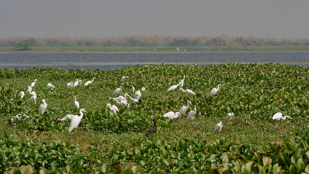
A wide shot of many white egrets standing and walking among dense green water hyacinth plants in a wetland environment with a large lake in the background.
A flock of egrets wading through the dense aquatic vegetation of Kolleru Bird Sanctuary.

Kolleru Bird Sanctuary history and protected-area timeline

Kolleru Bird Sanctuary was formally established in November 1999 under India's Wildlife Protection Act of 1972, giving formal protected status to a portion of the larger Kolleru Lake wetland. The move came as awareness grew about the ecological importance of the lake and the threats it faced from expanding aquaculture, drainage changes, and other forms of landscape alteration in the surrounding delta region.

A major milestone in the sanctuary's international profile came in August 2002, when Kolleru Lake was designated a Ramsar Wetland of International Importance. This designation acknowledged the lake's significance as a freshwater habitat of global value, particularly for waterbirds, and reinforced the rationale for its protected status under Indian law.

The sanctuary also sits within a landscape that has long supported human communities. The local Suryavansha Vaddi fisherfolk have historically claimed customary rights over the lake, tracing their association with the area back to the rule of the Eastern Ganga Dynasty in the 13th century. Their long-standing presence highlights the intertwined cultural and ecological history of Kolleru Lake and adds an important human dimension to the sanctuary's story.

Kolleru Bird Sanctuary landscape and geographic character

The landscape of Kolleru Bird Sanctuary is defined by the shallow, expansive freshwater basin of Kolleru Lake, set within the coastal plains between the Krishna and Godavari deltas. The terrain is remarkably flat, with the lake historically fluctuating between different water level contours through the year, expanding to over 900 square kilometers at high water and contracting significantly during the dry season. This natural rhythm of expansion and contraction has shaped a dynamic wetland landscape that changes visibly between the monsoon and the drier months.

Tall stands of reeds, especially Phragmites karka, dominate large portions of the visible landscape, forming dense green walls that rise up to several meters in height. Where the reeds thin out, open sheets of water emerge, interspersed with floating aquatic plants and submerged vegetation. The result is a patchwork of habitats, reed-choked channels, open shallows, and fringing marshes, that gives the area its distinctive scenic character and supports the high biodiversity for which the sanctuary is known.

Kolleru Bird Sanctuary ecosystems, habitats, and plant life

Ecologically, Kolleru Bird Sanctuary is a freshwater wetland system of considerable importance in peninsular India. The lake's shallow basin and seasonal water level changes support an unusually diverse assemblage of aquatic plant communities, ranging from tall emergent reeds to rooted and free-floating species in the open water. This vegetation diversity provides the structural foundation for the sanctuary's rich birdlife and the broader food web that depends on it.

The wetland sits within a wider network of deltaic and coastal habitats, and its natural character is shaped by the monsoon-driven hydrology of the Krishna and Godavari systems. Seasonal flooding replenishes nutrients, refreshes the marsh, and influences the distribution and productivity of vegetation across the sanctuary. Although the area has been altered by fishpond development and other interventions, the surviving mosaic of reedbeds, open water, and marsh remains ecologically significant at both regional and national scales.

Kolleru Bird Sanctuary wildlife and species highlights

The sanctuary is best known for its waterbirds, which use the lake in large numbers throughout much of the year. Egrets and other long-legged wading birds are particularly prominent, foraging in the shallow margins and roosting in the surrounding reedbeds. Beyond these charismatic species, the wetland supports storks, herons, ducks, and a wide variety of other resident and migratory birds that depend on the mosaic of open water and emergent vegetation.

The reedbeds of Phragmites karka, which can grow to roughly three meters in height, are especially important for wildlife. They provide shelter, nesting cover, and feeding substrate for many bird species and form much of the structural habitat within the sanctuary. The combination of dense reed cover, open water, and a productive aquatic plant community makes Kolleru a site where birdlife can occur at densities and diversities well above what is typical for the surrounding agricultural landscape.

Kolleru Bird Sanctuary conservation status and protection priorities

Kolleru Bird Sanctuary carries clear conservation significance at both national and international levels. Its foundation under the Wildlife Protection Act of 1972 reflects formal recognition of the wetland's ecological value, while the 2002 Ramsar designation placed the broader Kolleru Lake within a global framework for the protection of wetlands of international importance.

Beyond its formal designations, the sanctuary matters because it conserves a shrinking type of habitat. Large freshwater lakes in heavily populated coastal regions face intense pressure from aquaculture, drainage, encroachment, and water management changes, and Kolleru is no exception. Protecting even a portion of the lake helps maintain breeding and feeding habitat for waterbirds, preserves a representative stretch of reedbed and open-water wetland, and supports connectivity with other wetlands in the deltaic landscape. The sanctuary's continued existence is therefore an important anchor for wetland conservation in Andhra Pradesh.

Kolleru Bird Sanctuary cultural meaning and human context

The sanctuary and the lake it protects are deeply intertwined with the lives of local communities. The Vaddi fisherfolk, particularly the Suryavansha community, have a long historical connection with Kolleru Lake, tracing customary rights and traditional stewardship back many centuries. Their relationship with the lake has included not only fishing but also traditional forms of bird protection that predate modern conservation law.

This cultural layer adds important context to the sanctuary. Modern protected-area status and traditional community tenure both reflect an enduring recognition that Kolleru Lake is a shared natural and cultural resource. Respecting that history helps frame the sanctuary not just as a habitat reserve but as part of a living landscape in which people, water, and wildlife have long been connected.

Top sights and standout views in Kolleru Bird Sanctuary

Kolleru Bird Sanctuary's main highlights revolve around its sheer scale as a freshwater wetland and the exceptional birdlife it supports. The vast shallow basin, dense Phragmites reedbeds, and open water create a habitat mosaic of national and international importance, recognized through its Ramsar status. The sanctuary is also notable for the cultural depth of its surrounding landscape, where traditional fishing communities and centuries of human interaction have shaped both the lake itself and the way it is valued locally.

Best time to visit Kolleru Bird Sanctuary

The character of Kolleru Bird Sanctuary shifts with the seasons in ways that strongly influence both scenery and bird activity. During and shortly after the South Asian monsoon, elevated water levels expand the lake, refresh the reedbeds, and create ideal conditions for many waterbird species. In the drier months, receding water exposes more margins and concentrated feeding areas, which can also produce rewarding birdwatching opportunities, though the landscape itself becomes more varied and less uniformly aquatic.

For visitors focused on birdwatching, the cooler months are often associated with larger numbers of migratory and wintering waterbirds on Indian wetlands, while the post-monsoon period can be particularly rewarding for resident species as the habitat stabilizes. Timing a visit around these seasonal dynamics offers the best chance to experience the sanctuary at its fullest in terms of both water coverage and bird abundance.


Monthly climate preview

Long-term representative records of annual temperature and precipitation rhythm

Kolleru Bird Sanctuary Climate and Monthly Temperature Normals

Historical climate measurements outline the annual temperature progression and monthly precipitation patterns sampled across Kolleru Bird Sanctuary. Comprehensive twelve-month meteorological profiles provide deeper comparison data for this protected area.
Annual mean28 °C
24 °C32 °C
Jan24°
Feb27°
Mar29°
Apr31°
May32°
Jun30°
Jul29°
Aug28°
Sep28°
Oct27°
Nov25°
Dec24°
Warmest month
May

32.5 °C

Coolest month
December

23.7 °C

Wettest month
October

7.6 mm/day

Driest month
March

0.2 mm/day

Park location guide

Geography guide, regional context, and park location map for Kolleru Bird Sanctuary

Kolleru Bird Sanctuary park geography, regions, and map view in India

Understand where Kolleru Bird Sanctuary sits in India through a broader geographic reading of the surrounding landscape, nearby location context, and its mapped position within the national park landscape.

How Kolleru Bird Sanctuary fits into India

India is a South Asian country bordered by the Indian Ocean, Arabian Sea, and Bay of Bengal. It shares land borders with Pakistan, China, Nepal, Bhutan, Bangladesh, and Myanmar. The country has a population of over 1.4 billion people and operates as a federal parliamentary republic with its capital in New Delhi.

Wider geography shaping Kolleru Bird Sanctuary in India

India occupies the Indian subcontinent in South Asia, bordered by the Arabian Sea to the southwest, the Bay of Bengal to the southeast, and the Indian Ocean to the south. It shares land borders with Pakistan to the west, China, Nepal, and Bhutan to the north, and Bangladesh and Myanmar to the east. The territory also includes the Andaman and Nicobar Islands in the Indian Ocean.

Map view of Kolleru Bird Sanctuary

Use this park location map to pinpoint Kolleru Bird Sanctuary in India, understand its exact geographic position, and read its mapped placement within the surrounding landscape more clearly.

Pigeon | © OpenStreetMap contributors

Location context for Kolleru Bird Sanctuary

Andhra Pradesh

Visualizing wetland habitats, shallow waters, and reed-choked channels across the deltaic basin

Kolleru Bird Sanctuary Photos and Mapped Landscape Scenery

Visual documentation captures the expansive freshwater basin, dense Phragmites reedbeds, and shallow channels that define the protected sanctuary environment. Examining these protected area photographs reveals the shifting terrain and complex wetland habitats supporting large populations of migratory waterbirds.

A wide shot of many white egrets standing and walking among dense green water hyacinth plants in a wetland environment with a large lake in the background.

Park atlas

Compare surrounding regional geography and connected wetland conservation landscapes

Parks Near Kolleru Bird Sanctuary And Related Wetland Protected Areas

Browse other protected areas and regional wetland reserves situated across the surrounding river basin near Kolleru Bird Sanctuary. Comparing adjacent natural habitats provides broader geographic context for coastal plains and freshwater ecosystems.
Watercolor painting of a tranquil scene featuring green trees in the foreground, water, and soft, rolling hills in the background.
Wildlife reserveAndhra Pradesh
About 97 km away#1 closest

South

Krishna Wildlife Sanctuary: Coastal Mangrove Landscapes in the Krishna River Delta

Protected estuarine geography in Andhra Pradesh

Discover the geographic extent and habitat composition of Krishna Wildlife Sanctuary. This protected area features dense mangrove forests and intricate tidal waterways across deltaic islands, serving as an important ecological corridor along the Bay of Bengal coast in Andhra Pradesh.

Area
194.81 km²
IUCN
IV
Relief
Lowland
Scope
Terrestrial
National parkAndhra Pradesh
About 101 km away#2 closest

North

Papikonda National Park: Andhra Pradesh National Park Protected Landscape and Map Exploration

Mapped protected area boundaries and regional geography context.

Papikonda National Park is a designated national park in Andhra Pradesh, India, serving as a crucial component of regional protected landscapes. This entry provides detailed information on its mapped boundaries and geographic positioning, essential for atlas-based exploration and understanding its natural terrain. Users can explore the specific context of Papikonda National Park within the broader geography of Andhra Pradesh through its structured park data.

Area
1,012.86 km²
Established
1978
IUCN
II
Relief
Upland
A soft watercolor illustration of a river winding through green mangrove vegetation with distant hills under a light, hazy sky.
Wildlife reserveAndhra Pradesh
About 124 km away#3 closest

East

Coringa Wildlife Sanctuary: Mapping Protected Mangrove Wetlands in Andhra Pradesh

Coastal delta geography and estuarine tidal landscape exploration

Coringa Wildlife Sanctuary represents one of the largest continuous stretches of mangrove forests in India. This protected area along the Godavari Estuary offers a rich study in coastal geography, where complex tidal channels, backwater systems, and deltaic landforms create a unique, sediment-rich wetland environment essential for local avian and aquatic life.

Area
235.7 km²
Established
1978
IUCN
IV
Relief
Lowland
National parkIndia
About 252 km away#4 closest

North

Kanger Ghati National Park: National Park Atlas and Mapped Landscape Identity

Explore Kanger Ghati National Park's protected boundaries and regional geography.

Kanger Ghati National Park stands as a key protected national park entity within India, offering insights into its specific geographic setting and conservation landscape. This page details the park's mapped outlines and its role within the broader atlas of South Asia. Understand the natural terrain and regional context that define this protected area, providing a factual foundation for geographic discovery and landscape appreciation.

Area
200 km²
Established
1982
Relief
Mountain
Climate
Tropical
A horizontal watercolor painting depicting a landscape with a foreground pond, rolling hills covered in sparse forest, and distant purple-toned mountains under a white sky.
Wildlife reserveAndhra Pradesh
About 261 km away#5 closest

Northeast

Kambalakonda Wildlife Sanctuary: Mapped Geography and Protected Forest Landscapes

A diverse wildlife reserve in the Eastern Ghats foothills of Andhra Pradesh.

Kambalakonda Wildlife Sanctuary protects an essential patch of East Deccan dry evergreen forest near Visakhapatnam. The hilly topography and varied scrub-meadow ecosystems offer a distinct look at the region's biodiversity within the Eastern Ghats, serving as a primary site for conservation education and ecological study in southern India.

Area
70.7 km²
Established
1970
IUCN
IV
Relief
Upland
National parkTelangana
About 279 km away#6 closest

Northwest

Mahavir Harina Vanasthali National Park: Detailed Protected Landscape Atlas

Mapped boundaries and regional geographic context in Telangana.

Mahavir Harina Vanasthali National Park offers a unique perspective on protected landscapes within Telangana, India. This entry provides detailed information on the park's mapped boundaries and its significant role in the regional geography of the Deccan Plateau. Engage with structured data to understand its protected-area identity and its contribution to the atlas of South India's natural heritage.

Area
14.59 km²
Established
1975
IUCN
II
Relief
Upland
Wildlife reserveAndhra Pradesh
About 283 km away#7 closest

West

Gundla Brahmeswaram Wildlife Sanctuary: Mapped Geography and Protected Forest Landscapes

A vital plateau sanctuary within the Andhra Pradesh Eastern Ghats

Positioned across the rugged Nallamala Forest, this sanctuary protects a diverse array of dry deciduous woodlands and riparian corridors along the Gundlakamma River. As a key segment of the broader regional tiger habitat, the sanctuary provides essential biodiversity protection through its varied hill-pass topography and isolated plateau environment.

Area
1,194 km²
Established
1990
IUCN
IV
Relief
Mountain
National parkBijapur district
About 287 km away#8 closest

North

Indravati National Park: National Park Status and Geographic Landscape Context

Explore mapped boundaries and regional geography in Bijapur district.

Indravati National Park represents a significant protected natural area, classified as a national park within India. This entry offers detailed insights into its geographic placement within Bijapur district, emphasizing its mapped protected landscape and its role in regional geography. It serves as a vital point for structured discovery of natural areas and their environmental context.

Area
1,258.37 km²
Established
1981
IUCN
II
Relief
Highland

Common questions about visiting, size, designation, and location context for Kolleru Bird Sanctuary

Kolleru Bird Sanctuary FAQs for park facts, access, geography, and protected area context

Find quick answers about Kolleru Bird Sanctuary, including protected-area facts, park geography, trail and visitor context, and how the park fits into its surrounding country and regional landscape.
MoriAtlas Explorer

Continue Your Protected Areas Search Across the Global Atlas

Deepen your exploration by continuing the structured search for national parks and protected areas worldwide. Utilize the comprehensive filtering capabilities to compare different conservation landscapes and refine your understanding of global park geography. Discover more about the distribution and characteristics of protected natural areas.

Global natural geography