

Mori Atlas logo
National parkMahavir Harina Vanasthali National Park

Discover the mapped boundaries and regional context of this important national park in South India.

Mahavir Harina Vanasthali National Park: Protected Landscape Geography in Telangana

Mahavir Harina Vanasthali National Park stands as a key protected area within the state of Telangana, India. This page provides an atlas-oriented view, focusing on the park's geographic identity, its mapped natural landscape, and its place within the broader Deccan Plateau region. Understand the protected boundaries and the unique regional context that defines this significant national park for structured geographic discovery.

National ParkDeer SanctuaryUrban ForestDry Deciduous ForestWildlife HabitatBirdwatching

Mahavir Harina Vanasthali National Park

National park

Park overview

Structured park overview, official facts, and landscape profile for Mahavir Harina Vanasthali National Park

Mahavir Harina Vanasthali National Park park facts, protected area profile, and essential visitor context

Review the core facts for Mahavir Harina Vanasthali National Park, including designation, size, terrain, visitor scale, habitats, and operating context in one park-focused overview.

About Mahavir Harina Vanasthali National Park

Mahavir Harina Vanasthali National Park represents a significant conservation success story in the heart of Hyderabad, one of India's largest metropolitan cities. Located in the Vanasthalipuram area on the Hyderabad-Vijayawada road, the park offers a rare natural retreat within the urban landscape, spanning roughly 3605 acres of protected land. The park's establishment in 1975 marked an important milestone in regional conservation efforts, converting what was once an exclusive hunting ground into a protected sanctuary that preserves both ecological heritage and cultural memory. The transformation from a private Nizam's hunting ground to a national park reflects broader shifts in how society values wildlife and natural landscapes, moving from exploitation toward preservation. Today, the park serves multiple functions: as a biodiversity refuge, as an environmental lung for the densely populated city, and as an educational resource for understanding semi-deciduous forest ecosystems. The Telangana Forest Department maintains the park and facilitates visitor access through organized safari experiences, allowing people to observe wildlife in their natural habitat while generating awareness about conservation needs.

Quick facts and research context for Mahavir Harina Vanasthali National Park

Located in Vanasthalipuram, Hyderabad, Telangana, this national park spans 14.59 square kilometers and was established in 1975. It is classified as an IUCN Category II protected area. The park features dry deciduous forest mixed with scrub jungle and grasslands, with terrain that varies from hilly to gently rolling. Notable tree species include sandalwood, rosewood, teak, and various acacias. The park is maintained by the Telangana Forest Department and offers guided safari tours for visitors.

Protection and recognition

Analyzing the official terrestrial conservation framework and global designations

Mahavir Harina Vanasthali National Park Protection Status and Designation

Review the official protection status and terrestrial conservation framework established for Mahavir Harina Vanasthali National Park. Accessing standardized management data offers clear context on global conservation boundaries and regional environmental framework alignments.

Protection details

Protection scope
Terrestrial
Park context

Deeper park guide and search-rich context for Mahavir Harina Vanasthali National Park

Mahavir Harina Vanasthali National Park history, landscape, wildlife, and travel context

Explore Mahavir Harina Vanasthali National Park through its history, landscape character, ecosystems, wildlife, conservation priorities, cultural context, and seasonal travel timing in a structured park guide built for atlas discovery and search intent.

Why Mahavir Harina Vanasthali National Park stands out

Mahavir Harina Vanasthali is best known as a deer-focused protected area, housing significant populations of blackbucks (the state animal of Andhra Pradesh) and chitals (spotted deer). It is renowned as the largest green lung space in Hyderabad, providing critical habitat for wildlife within an urban environment. The park is also recognized for its Jain heritage connection through its naming after Mahavir, the 24th Tirthankara, and for being a former private hunting ground of the Nizam of Hyderabad that has been transformed into a conservation area.

Mahavir Harina Vanasthali National Park history and protected-area timeline

The park's history is deeply intertwined with both religious commemoration and colonial-era land use. It was established in 1975 specifically to honor Mahavir, the 24th Tirthankara of Jainism, coinciding with the 2500th anniversary of his nirvana. This naming reflects the significant Jain community presence in the Hyderabad region and their cultural connection to the landscape. Prior to its establishment as a protected area, the land served as an exclusive private hunting ground for the Nizam, the monarchical rulers of Hyderabad state. The conversion of this former hunting grounds into a deer park represented a deliberate effort to preserve what was then recognized as a precious heritage and to rehabilitate the land for wildlife conservation. Over the decades, the park has evolved from a focused deer sanctuary to a comprehensive national park protecting diverse flora and fauna within the urban sphere.

Mahavir Harina Vanasthali National Park landscape and geographic character

The park's physical landscape features dry deciduous forest vegetation interspersed with scrub jungle and open grasslands, creating a heterogeneous habitat mosaic. The terrain is characterized by variation, moving from hilly sections to gently rolling plains, which contributes to the park's visual diversity and ecological complexity. This topography supports different microhabitats within a relatively compact area, allowing various species to find suitable living conditions. The vegetation pattern, dominated by species such as sandalwood, rosewood, teak, palas, amalthas, albizzias, and acacias, creates a semi-open forest structure that facilitates wildlife movement while providing sufficient cover. The landscape's proximity to the urban environment of Hyderabad creates a stark contrast, with the park representing an island of natural terrain surrounded by rapidly developing metropolitan infrastructure.

Mahavir Harina Vanasthali National Park ecosystems, habitats, and plant life

The ecological character of Mahavir Harina Vanasthali is defined by its dry deciduous forest ecosystem, a vegetation type adapted to the regional climate patterns of central Telangana. The combination of forest, scrub, and grassland habitats supports considerable biodiversity despite the park's urban setting. The presence of economically valuable species such as sandalwood and rosewood indicates the ecological significance of preserving this area, as these species have important cultural and commercial value in India. The habitat structure provides suitable conditions for both forest-dwelling species and more open-country animals, creating a diverse ecological community within relatively limited space.

Mahavir Harina Vanasthali National Park wildlife and species highlights

The park supports a remarkable diversity of wildlife, with particular emphasis on ungulate species. Blackbucks, the state animal of Andhra Pradesh, are present in significant numbers and represent one of the park's flagship species. Chitals (spotted deer) also thrive here, along with wild boars and smaller mammals including porcupines and civets. Predatory species include panthers, though these are encountered less frequently. The avian fauna is particularly impressive, with over 120 recorded bird species including short-toed eagles, Indian pond herons, egrets, kingfishers, and cormorants. Reptile diversity includes water monitors and approximately 30 reptile species, contributing to the park's overall ecological richness. The fan-throated lizard and various beetle species have also been documented within the park boundaries.

Mahavir Harina Vanasthali National Park conservation status and protection priorities

As an IUCN Category II national park, Mahavir Harina Vanasthali carries formal recognition of its conservation significance. The park represents an important green buffer within the rapidly urbanizing Hyderabad metropolitan area, serving critical ecological functions despite its relatively small size. Its conservation value is amplified by the surrounding urban context, as it provides essential habitat for wildlife species that would otherwise be displaced by city expansion. The transformation of a former hunting ground into a protected area demonstrates successful habitat restoration and conservation intervention. The presence of economically important tree species like sandalwood adds another dimension to conservation considerations, as these species face pressures from illegal extraction in many parts of their range.

Mahavir Harina Vanasthali National Park cultural meaning and human context

The park's name derives directly from Jain religious tradition, honoring Mahavir, the 24th Tirthankara, whose 2500th nirvana anniversary in 1975 prompted the establishment of this protected area. This Jain heritage connection gives the park additional cultural significance beyond its ecological value. The transition from a private Nizam's hunting ground to a public conservation area also reflects changing attitudes toward wildlife and natural spaces in the region, moving from elite recreational use toward broader public benefit and biodiversity preservation. The park's location in Vanasthalipuram places it within a rapidly developing area of Hyderabad, making its preservation of cultural and natural heritage particularly significant as urban expansion continues.

Top sights and standout views in Mahavir Harina Vanasthali National Park

Mahavir Harina Vanasthali National Park stands out as Hyderabad's largest urban forest reserve, offering a unique combination of religious heritage, colonial history, and biodiversity conservation. The park's significant blackbuck population, along with over 120 bird species and diverse reptile fauna, makes it a notable destination for wildlife observation within a major Indian city. The presence of valuable timber species including sandalwood and rosewood adds ecological and economic significance. Its transformation from an exclusive Nizam's hunting ground to a protected national park illustrates a meaningful conservation journey that offers educational value about changing land use practices.

Best time to visit Mahavir Harina Vanasthali National Park

The park can be visited throughout the year, though the winter months from October to March generally offer more comfortable conditions for wildlife viewing and outdoor exploration. During this period, the weather is cooler and animals are more active during daylight hours, improving sighting opportunities. The summer months can be quite warm, potentially limiting daytime activity levels for both visitors and wildlife. The monsoon season brings lush vegetation to the park, which while visually appealing, may make wildlife observation more challenging as animals disperse into denser cover.
Monthly climate preview

Thirty-year baseline climate measurements and regional monthly observations in Telangana

Average Temperature and Weather by Month for Mahavir Harina Vanasthali National Park

Long-term data at a representative coordinate of 494 meters elevation shows average maximum temperatures peaking above 43 degrees Celsius alongside highly seasonal precipitation patterns. Accessing the complete climate profile provides detailed historical averages of monthly temperature variations and rainfall shifts for deep geographic comparison.
Annual mean26 °C
21 °C33 °C
Jan22°
Feb25°
Mar29°
Apr32°
May33°
Jun29°
Jul26°
Aug25°
Sep25°
Oct24°
Nov22°
Dec21°
Warmest month
May

33.3 °C

Coolest month
December

20.5 °C

Wettest month
August

6.5 mm/day

Driest month
December

0.1 mm/day

Park location guide

Geography guide, regional context, and park location map for Mahavir Harina Vanasthali National Park

Mahavir Harina Vanasthali National Park park geography, regions, and map view in India

Understand where Mahavir Harina Vanasthali National Park sits in India through a broader geographic reading of the surrounding landscape, nearby location context, and its mapped position within the national park landscape.

How Mahavir Harina Vanasthali National Park fits into India

India is a South Asian country bordered by the Indian Ocean, Arabian Sea, and Bay of Bengal. It shares land borders with Pakistan, China, Nepal, Bhutan, Bangladesh, and Myanmar. The country has a population of over 1.4 billion people and operates as a federal parliamentary republic with its capital in New Delhi.

Wider geography shaping Mahavir Harina Vanasthali National Park in India

India occupies the Indian subcontinent in South Asia, bordered by the Arabian Sea to the southwest, the Bay of Bengal to the southeast, and the Indian Ocean to the south. It shares land borders with Pakistan to the west, China, Nepal, and Bhutan to the north, and Bangladesh and Myanmar to the east. The territory also includes the Andaman and Nicobar Islands in the Indian Ocean.

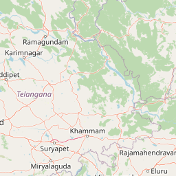
Map view of Mahavir Harina Vanasthali National Park

Use this park location map to pinpoint Mahavir Harina Vanasthali National Park in India, understand its exact geographic position, and read its mapped placement within the surrounding landscape more clearly.

Pigeon | © OpenStreetMap contributors

Location context for Mahavir Harina Vanasthali National Park

Telangana
Park atlas

Trace the regional spread of national parks and protected landscapes across Telangana, India, for deeper geographic comparison.

Discover Other Protected Areas Near Mahavir Harina Vanasthali National Park, Hyderabad

Explore a curated list of national parks and protected areas located in the vicinity of Mahavir Harina Vanasthali National Park, including diverse wildlife habitats and conservation landscapes in Telangana. Comparing these sites offers valuable atlas-style insights into regional ecology, protected area distribution, and distinct conservation efforts across India.
National parkTelangana
About 43 km away#1 closest

Southwest

Kasu Brahmananda Reddy National Park: Telangana National Park Geographic Atlas

Mapped protected landscapes and regional context in India.

This detail entry for Kasu Brahmananda Reddy National Park provides essential context for understanding its protected landscape identity within Telangana. Explore its mapped boundaries, regional geographic setting on the Deccan Plateau, and discover how this national park contributes to the atlas of protected areas in South India, offering a grounded perspective for geographic exploration.

Area
1.6 km²
Established
1998
Climate
Tropical
Access
Easy access
National parkTelangana
About 54 km away#2 closest

Southwest

Mrugavani National Park: Telangana's Protected Area within the Deccan Plateau's Natural Landscape

Explore undulating terrain and tropical dry forest ecosystems.

Mrugavani National Park represents a significant protected landscape within Telangana, India, characterized by its characteristic Deccan Plateau geography. Covering 1,211 acres, this national park features a terrain of rocky outcrops and undulating topography supporting a tropical dry deciduous forest ecosystem. It serves as a critical refuge for native flora and fauna, including a notable population of spotted deer, and offers a valuable case study in regional conservation and mapped protected areas near urban centers.

Area
4.9 km²
Established
1994
IUCN
II
Relief
Upland
Wildlife reserveAndhra Pradesh
About 210 km away#3 closest

South

Rollapadu Wildlife Sanctuary: Mapping the Protected Grassland Landscapes of Andhra Pradesh

A vital semi-arid wildlife reserve and avian conservation zone.

Rollapadu Wildlife Sanctuary provides a focused look at the environmental challenges facing semi-arid grassland ecosystems in southern India. Home to the great Indian bustard and diverse wintering waterbirds, this protected area illustrates the intricate relationship between scrub forest patches, open grazing lands, and the surrounding agricultural periphery in the Nandyal district.

Area
6.14 km²
Established
1988
IUCN
IV
Relief
Upland
Wildlife reserveAndhra Pradesh
About 215 km away#4 closest

South

Gundla Brahmeswaram Wildlife Sanctuary: Mapped Geography and Protected Forest Landscapes

A vital plateau sanctuary within the Andhra Pradesh Eastern Ghats

Positioned across the rugged Nallamala Forest, this sanctuary protects a diverse array of dry deciduous woodlands and riparian corridors along the Gundlakamma River. As a key segment of the broader regional tiger habitat, the sanctuary provides essential biodiversity protection through its varied hill-pass topography and isolated plateau environment.

Area
1,194 km²
Established
1990
IUCN
IV
Relief
Mountain
Wildlife reserveAndhra Pradesh
About 279 km away#5 closest

Southeast

Kolleru Bird Sanctuary Wildlife Reserve: Protected Wetland and Basin Geography Atlas

Mapped freshwater wetlands in Andhra Pradesh

Kolleru Bird Sanctuary represents an essential protected freshwater basin situated in the deltaic plains of Andhra Pradesh. The area supports a dynamic habitat of open water and reedbed environments that transition through the seasons. This record provides a clear geographic view of the sanctuary, highlighting its role as a key Ramsar-recognized wetland within the regional landscape context.

Area
673 km²
Established
1999
IUCN
IV
Relief
Lowland
National parkAndhra Pradesh
About 287 km away#6 closest

East

Papikonda National Park: Andhra Pradesh National Park Protected Landscape and Map Exploration

Mapped protected area boundaries and regional geography context.

Papikonda National Park is a designated national park in Andhra Pradesh, India, serving as a crucial component of regional protected landscapes. This entry provides detailed information on its mapped boundaries and geographic positioning, essential for atlas-based exploration and understanding its natural terrain. Users can explore the specific context of Papikonda National Park within the broader geography of Andhra Pradesh through its structured park data.

Area
1,012.86 km²
Established
1978
IUCN
II
Relief
Upland
National parkBijapur district
About 297 km away#7 closest

Northeast

Indravati National Park: National Park Status and Geographic Landscape Context

Explore mapped boundaries and regional geography in Bijapur district.

Indravati National Park represents a significant protected natural area, classified as a national park within India. This entry offers detailed insights into its geographic placement within Bijapur district, emphasizing its mapped protected landscape and its role in regional geography. It serves as a vital point for structured discovery of natural areas and their environmental context.

Area
1,258.37 km²
Established
1981
IUCN
II
Relief
Highland
National parkChandrapur district
About 302 km away#8 closest

North

Tadoba Andhari Tiger Reserve National Park: Mapped Protected Landscape Discovery

Geographic context within Chandrapur district, India.

Investigate Tadoba Andhari Tiger Reserve as a national park, focusing on its distinct protected landscape characteristics. This detail page provides structured insights into its mapped boundaries and its position within the regional geography of Chandrapur district, essential for a comprehensive understanding of India's protected natural areas.

Area
1,727.59 km²
Established
1955
IUCN
II
Relief
Highland

Common questions about visiting, size, designation, and location context for Mahavir Harina Vanasthali National Park

Mahavir Harina Vanasthali National Park FAQs for park facts, access, geography, and protected area context

Find quick answers about Mahavir Harina Vanasthali National Park, including protected-area facts, park geography, trail and visitor context, and how the park fits into its surrounding country and regional landscape.
MoriAtlas Explorer

Continue Your Protected Areas Search Across the Global Atlas

Deepen your exploration by continuing the structured search for national parks and protected areas worldwide. Utilize the comprehensive filtering capabilities to compare different conservation landscapes and refine your understanding of global park geography. Discover more about the distribution and characteristics of protected natural areas.

Global natural geography