Mori Atlas logo
Wildlife reserveKootznoowoo Wilderness

Tracing the mapped boundaries of old-growth temperate rainforest and rugged island terrain

Kootznoowoo Wilderness: An In-Depth Geographic Atlas of Southeast Alaska Coastal Protected Lands

Kootznoowoo Wilderness encompasses nearly one million acres of Admiralty Island, serving as a flagship protected area within the Tongass National Forest. This expansive wildlife reserve defines the character of Southeast Alaska through its dense canopy of Sitka spruce and western hemlock, winding salmon-rich streams, and complex network of coastal fjords. Mapping this region reveals an intact temperate rainforest ecosystem that sustains high densities of brown bears and coastal predators across a roadless, mountainous island landscape.

wilderness areatemperate rainforestold-growth forestSitka sprucebrown bearsAlexander Archipelago wolf

Kootznoowoo Wilderness

Wildlife reserve

Park overview

Structured park overview, official facts, and landscape profile for Kootznoowoo Wilderness

Kootznoowoo Wilderness park facts, protected area profile, and essential visitor context

Review the core facts for Kootznoowoo Wilderness, including designation, size, terrain, visitor scale, habitats, and operating context in one park-focused overview.

About Kootznoowoo Wilderness

Kootznoowoo Wilderness is a 979,079-acre protected wilderness on Admiralty Island, the largest island in the Alexander Archipelago of Southeast Alaska. The name Kootznoowoo comes from the Tlingit people of the region, and the wilderness lies within the traditional territories of the Angoon Tlingit community, the only permanent settlement on the island. The area is administered by the U.S. Forest Service and is nested within Admiralty Island National Monument, which in turn is part of the vast Tongass National Forest, the largest national forest in the United States.

Geographically, Kootznoowoo occupies most of Admiralty Island except for the Mansfield Peninsula, the village of Angoon, and Native-owned lands along the western shore. The terrain is a classic example of Southeast Alaskan geography: deeply indented coastlines, glacially carved fjords, mountainous interiors, and densely forested valleys that descend to the sea. The maritime climate delivers heavy precipitation, mild temperatures, and persistent moisture, conditions that have produced some of the most luxuriant temperate rainforest in North America.

Ecologically, the wilderness is defined by its old-growth coastal forest. Sitka spruce and western hemlock trees rise to extraordinary heights, creating a shaded interior world draped in mosses, lichens, and a deep carpet of ferns. Fallen logs, slow-moving streams, and beaver-influenced wetlands punctuate the forest floor. These conditions support an unusually rich fauna for such a northern latitude, including brown bears, black bears, the endemic Alexander Archipelago wolf, Sitka black-tailed deer, moose, harbor seals, bald eagles, red fox, all five species of Alaskan Pacific salmon, and two of the few amphibians adapted to life in Alaska: the rough-skinned newt and the boreal toad.

Beyond its biological importance, Kootznoowoo Wilderness is significant for what it lacks: roads, large-scale development, and easy human access. The combination of remoteness, intact forest cover, and abundant prey has allowed predator populations to remain robust and ecologically functional. As a result, the wilderness functions not only as a scenic reserve but as a working laboratory for understanding coastal temperate rainforest ecosystems and the predator-prey dynamics that structure them.

Quick facts and research context for Kootznoowoo Wilderness

Kootznoowoo Wilderness covers approximately 979,079 acres on Admiralty Island in Southeast Alaska and is administered by the U.S. Forest Service as a component of Admiralty Island National Monument within Tongass National Forest. It was formally designated as wilderness on December 2, 1980, under the federal wilderness system.

The wilderness is a temperate rainforest landscape rather than a typical alpine or subarctic Alaskan environment, dominated by old-growth Sitka spruce and western hemlock. It is internationally recognized for supporting one of the highest concentrations of brown bears anywhere, along with a genetically distinct subspecies of coastal gray wolf known as the Alexander Archipelago wolf.

Protection and recognition

Documented protection scope and international recognition context for Kootznoowoo Wilderness

Kootznoowoo Wilderness Protection Status and Territorial Designation

Kootznoowoo Wilderness maintains a documented terrestrial protection scope within its designated natural boundary. Official records outline the established conservation status and governance history for this protected area.

Protection details

Protection scope
Terrestrial
Transboundary protection
No
Park context

Deeper park guide and search-rich context for Kootznoowoo Wilderness

Kootznoowoo Wilderness history, landscape, wildlife, and travel context

Explore Kootznoowoo Wilderness through its history, landscape character, ecosystems, wildlife, conservation priorities, cultural context, and seasonal travel timing in a structured park guide built for atlas discovery and search intent.

Why Kootznoowoo Wilderness stands out

Kootznoowoo Wilderness is best known for its dense old-growth temperate rainforest and for harboring one of the highest densities of brown bears on Earth. The island's remote, roadless character has allowed populations of large mammals and intact predator-prey relationships to persist in a way that few other North American landscapes still support. Equally distinctive is the contrast it provides with the rest of Alaska: where much of the state is defined by ice, tundra, and boreal forest, Kootznoowoo is defined by towering conifers, a fern-covered understory, salmon-rich streams, and a maritime climate. This combination of rainforest ecosystem, high bear density, and intact coastal food web defines the wilderness's international reputation.

Kootznoowoo Wilderness history and protected-area timeline

Kootznoowoo Wilderness was formally designated on December 2, 1980, as part of the larger wave of Alaska wilderness protections that followed the Alaska National Interest Lands Conservation Act of 1980. The designation placed the bulk of Admiralty Island under the highest level of federal land protection available in the United States, locking in its wilderness character against logging, road-building, and large-scale development.

The broader landscape had already gained federal attention through its inclusion in Admiralty Island National Monument, proclaimed to protect the island's outstanding natural and cultural values. The monument, and later the wilderness, were nested within Tongass National Forest, the umbrella federal forest that encompasses Southeast Alaska's coastal islands and mainland.

Long before federal protection, Admiralty Island was home to Tlingit communities who used the island's fish, game, forests, and waterways for thousands of years. The village of Angoon, located outside the wilderness boundary, is the only permanent present-day settlement and represents a continuing Tlingit presence on the island. Indigenous place names, resource use patterns, and seasonal movement across Kootznoowoo's lands and waters are part of the deeper, undocumented history of the region and continue to shape its cultural context today.

Kootznoowoo Wilderness landscape and geographic character

The landscape of Kootznoowoo Wilderness is a textbook example of Southeast Alaskan topography: a mountainous, fjord-indented island with steep slopes that plunge directly into the sea. Glacial carving has left behind a coastline fragmented into countless inlets, bays, and channels, while the interior rises into rugged, forested ridges and peaks. There are no roads and no broad valley plains of the type seen elsewhere in Alaska; instead, the terrain is broken, forested, and dissected by water.

What sets Kootznoowoo apart visually is its continuous blanket of temperate rainforest. Old-growth Sitka spruce and western hemlock form tall, layered canopies that drape over the contours of the land, while dense shrub layers and fern undergrowth fill the spaces between. Streams and small rivers course through mossy corridors toward the coast, often interrupted by beaver ponds and estuarine flats. The result is a landscape that feels uniformly forested from shoreline to ridge, with few of the open vistas or icy expanses typical of mainland Alaska.

Kootznoowoo Wilderness ecosystems, habitats, and plant life

The ecological identity of Kootznoowoo Wilderness is rooted in the temperate rainforest biome of the Pacific Northwest coast, an ecosystem that reaches the northern limit of its global range in Southeast Alaska. Persistent rainfall, mild temperatures, and the moderating influence of the Pacific Ocean create the humid, stable conditions that allow old-growth conifer forests to thrive. This is structurally very different from the boreal forest and tundra that dominate elsewhere in Alaska.

Mature Sitka spruce and western hemlock stands dominate the canopy, with smaller contributions from other conifers, deciduous trees, and a dense understory of shrubs. The forest floor is a moist, decomposing world of mosses, lichens, ferns, fallen logs, and thick duff that supports a wide range of invertebrates, amphibians, and small mammals. Beaver-modified wetland complexes, tidal estuaries, and salmon-bearing streams interweave the upland forest, creating a mosaic of habitats that sustains the wilderness's remarkable productivity.

Because the forest is largely intact and has never been extensively logged, it retains ecological features, such as large old trees, abundant downed wood, and complex stream networks, that have been lost from many other temperate rainforests. This structural complexity is widely considered central to the long-term health of the ecosystem and to the species that depend on it.

Kootznoowoo Wilderness wildlife and species highlights

Kootznoowoo Wilderness is internationally renowned for its exceptionally dense population of brown bears, one of the highest concentrations recorded anywhere in the world. Salmon runs, berry-producing openings, and the absence of hunting pressure within the wilderness boundary combine to support bears in numbers that far exceed what is typical for mainland Alaska. The result is a near-constant presence of bears along salmon streams, in estuaries, and along forest edges.

The island's predator community extends beyond brown bears to include the Alexander Archipelago wolf, a unique subspecies of coastal gray wolf that occurs only on the islands of Southeast Alaska. Black bears, Sitka black-tailed deer, moose, red fox, and harbor seals add further depth to the mammal fauna. The marine environment brings additional wildlife into the wilderness, including bald eagles, which nest in the tall conifers and feed heavily on salmon, and a wide variety of seabirds and waterfowl that use the coastlines and inland waters.

Aquatic wildlife is equally central to the ecosystem. All five species of Alaskan salmon return to the island's streams, fueling the entire food web from bears and wolves to eagles and invertebrates. The rough-skinned newt and boreal toad, two of the only amphibian species adapted to the climatic conditions of Alaska, occur in the wetlands and forest pools, completing a wildlife portrait that is unusually diverse for the region's latitude.

Kootznoowoo Wilderness conservation status and protection priorities

From a conservation perspective, Kootznoowoo Wilderness is significant because it preserves a large, intact block of coastal temperate rainforest at a time when such ecosystems have become rare globally. Its wilderness designation prohibits road construction, logging, and most forms of mechanized development, ensuring that the structural and ecological features of the old-growth forest remain intact. The wilderness is also a stronghold for the Alexander Archipelago wolf, a subspecies with a restricted range that depends on the protected forest conditions of Admiralty Island and similar Southeast Alaskan landscapes.

The wilderness's brown bear density makes it a globally important reference site for understanding predator-prey dynamics, salmon ecosystem linkages, and human-wildlife coexistence in a roadless environment. Because the island is accessible primarily by boat or floatplane, the area receives relatively low visitor pressure, which itself is a conservation asset. Together, these qualities make Kootznoowoo one of the most ecologically valuable wilderness areas in the United States.

Kootznoowoo Wilderness cultural meaning and human context

Kootznoowoo, like the rest of Admiralty Island, is the ancestral homeland of the Tlingit people, and the wilderness sits within a landscape shaped by Indigenous presence for thousands of years. The Tlingit place name itself reflects the deep cultural relationship between local communities and the island's natural systems, including its salmon streams, bear populations, and forested valleys, all of which sustained traditional subsistence practices.

The village of Angoon, located just outside the wilderness boundary on the island's western coast, remains a living Tlingit community and a key partner in regional land management discussions. Subsistence hunting, fishing, and gathering continue to connect Angoon residents to the broader island landscape, even within the formally protected wilderness. The cultural ties between the Tlingit and Admiralty Island are widely recognized as integral to the area's identity, alongside its ecological importance.

Top sights and standout views in Kootznoowoo Wilderness

Kootznoowoo Wilderness's most distinctive features are its unbroken canopy of old-growth Sitka spruce and western hemlock, the lush fern understory beneath, and the exceptionally dense population of brown bears that depends on its salmon-rich streams. Few places in North America combine such a high concentration of large predators with such an intact coastal rainforest setting.

Equally noteworthy is the wilderness's hosting of the Alexander Archipelago wolf, its role as nesting habitat for thousands of bald eagles, and its position as one of the few Alaskan landscapes where visitors can walk beneath towering rainforest rather than across tundra or ice. The wilderness's sheer size, roadless condition, and integration into Tongass National Forest and Admiralty Island National Monument all reinforce its status as a flagship Southeast Alaskan wilderness.

Best time to visit Kootznoowoo Wilderness

The character of a visit to Kootznoowoo Wilderness shifts meaningfully with the seasons. Summer is the most accessible period, when longer daylight hours, milder temperatures, and active salmon runs make wildlife viewing, especially brown bears feeding on salmon, an experience that defines a trip to Admiralty Island.
Monthly climate preview

Long-term representative measurements tracking monthly temperature and precipitation rhythm

Kootznoowoo Wilderness Climate Normals, Annual Temperature and Precipitation Patterns

Kootznoowoo Wilderness records average monthly temperatures spanning sub-zero winter minimums to mild summer maximums alongside sustained precipitation across the year. Reviewing the complete twelve-month climatology profile provides deeper analytical depth into measured long-term environmental patterns at this representative coordinate.
Annual mean6 °C
-2 °C13 °C
Jan-2°
Feb-1°
Mar
Apr
May
Jun12°
Jul13°
Aug13°
Sep10°
Oct
Nov
Dec
Warmest month
July

13.4 °C

Coolest month
January

-1.5 °C

Wettest month
October

9.4 mm/day

Driest month
May

3.9 mm/day

Park location guide

Geography guide, regional context, and park location map for Kootznoowoo Wilderness

Kootznoowoo Wilderness park geography, regions, and map view in United States of America

Understand where Kootznoowoo Wilderness sits in United States of America through a broader geographic reading of the surrounding landscape, nearby location context, and its mapped position within the national park landscape.

How Kootznoowoo Wilderness fits into United States of America

The United States of America is a federal presidential republic and one of the world's largest countries by area and population. It consists of 50 states across a vast territory spanning multiple time zones, with its capital in Washington, D.C. and largest city in New York City. The nation has a diverse economy, influential political system, and significant cultural and military presence globally.

Wider geography shaping Kootznoowoo Wilderness in United States of America

The United States occupies a vast territory in North America, bordered by Canada to the north and Mexico to the south. The 48 contiguous states stretch from the Atlantic to the Pacific Ocean, while Alaska occupies the northwestern region and Hawaii is an archipelago in the Pacific. The country encompasses diverse terrain including the Rocky Mountains, Appalachian Mountains, Great Plains, and extensive river systems.

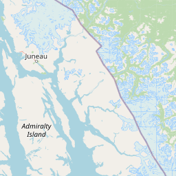
Map view of Kootznoowoo Wilderness

Use this park location map to pinpoint Kootznoowoo Wilderness in United States of America, understand its exact geographic position, and read its mapped placement within the surrounding landscape more clearly.

Pigeon | © OpenStreetMap contributors

Location context for Kootznoowoo Wilderness

Alaska
Recorded earthquake history

Explore Historical Earthquake Records for Kootznoowoo Wilderness

Examine the seismic history of Admiralty Island through a structured collection of documented earthquake events. This catalogue offers transparent access to historical magnitude, depth, and proximity data for events recorded near the Kootznoowoo Wilderness, helping researchers and observers analyze regional activity through the MoriAtlas dataset.

Kootznoowoo Wilderness Earthquake History

Catalogued events

32 events

Strongest magnitude

Magnitude 3.8

Most recent event

Sep 28, 2021

This history includes earthquakes recorded inside the park or within 50 km of its borders

Park atlas

Compare regional coastal rainforests and adjacent protected landscapes across Southeast Alaska.

Explore Parks Near Kootznoowoo Wilderness and Surrounding Protected Areas

Continue browsing national parks and protected areas near Kootznoowoo Wilderness to examine related temperate rainforest ecosystems. Comparing adjacent regional geography reveals broader patterns in coastal terrain, old-growth canopies, and island wilderness habitats.
Protected landscapeAlaska
About 80 km away#1 closest

West

Tongass National Forest: Geographic Overview of Alaska Coastal Wilderness

Mapped temperate rainforests, fjords, and mountain ranges

Trace the extensive boundaries of Tongass National Forest, a massive protected landscape in Southeast Alaska. This atlas detail covers the unique geography of the Alexander Archipelago, where island wilderness meets the tidewater glaciers and old growth forests of the Coast Mountains. Gain insight into the terrain, ecosystem distribution, and regional context of this globally rare coastal rainforest environment.

Area
68,000 km²
Established
1907
Visitors
1.9M annual
Relief
Mountain
A minimalist watercolor painting showing layered hills and coastal terrain in soft shades of green, gray, and pink, resembling the Alaskan wilderness.
Wildlife reserveAlaska
About 86 km away#2 closest

South

Kuiu Wilderness: An Alaska Protected Area of Temperate Rainforest and Fjord Geography

A remote wilderness expanse within the Alexander Archipelago

The Kuiu Wilderness serves as a primary example of coastal conservation in Alaska, offering a vast roadless territory that spans from sea level to alpine elevations. Mapped through a series of deep fjords and temperate rainforests, this reserve provides a critical look at the complex landscape transitions that define the ecology of the Alexander Archipelago.

Area
245.16 km²
Established
1990
Relief
Mountain
Climate
Temperate
State or regional parkBritish Columbia
About 129 km away#3 closest

Southeast

Great Glacier Provincial Park: Glacial Geography and Protected Wilderness in Northern British Columbia

A rugged mountain landscape within the Stikine River corridor.

Great Glacier Provincial Park protects a compact, visually intense glacial environment along the Stikine River. Established to preserve the dramatic Great Glacier as it descends from the Boundary Ranges, this protected area features deep river valleys, steep mountainous slopes, and a unique ecological transition zone near the international border.

Area
93 km²
Established
2001
IUCN
II
Relief
Mountain
National parkAlaska
About 137 km away#4 closest

Northwest

Glacier Bay National Park and Preserve: Alaska National Park Geographic Atlas

Mapped protected area context within Alaska's natural landscapes.

Glacier Bay National Park and Preserve serves as a vital protected landscape in Alaska, offering deep insights into regional geography and park boundaries. This detail page provides an atlas-centric view of the park, focusing on its role as a protected natural area and its unique position within the geographic tapestry of Alaska. Engage with structured data that illuminates the park's mapped terrain and its significance as a conservation landscape.

Area
13,045 km²
Established
1980
IUCN
V
Visitors
545.8K annual
State or regional parkBritish Columbia
About 200 km away#5 closest

Southeast

Lava Forks Provincial Park: Geological Mapping and Protected Area Overview

Remote volcanic wilderness in northern British Columbia

This protected area preserves the fresh geological features created by the 1904 eruption of The Volcano. The site offers a detailed look at ash dunes, lava flows, and water-filled potholes within a remote northern British Columbia setting. Use this atlas resource to examine the park boundaries and the unique terrain that characterizes this significant transboundary conservation landscape.

Area
74.63 km²
Established
2001
IUCN
III
Relief
Mountain
Wildlife reserveYukon
244 km away#6 closest

North

Nisutlin River Delta National Wildlife Area: Yukon Delta and Wetland Geography

Protected boreal river delta and lake ecosystem.

The Nisutlin River Delta National Wildlife Area occupies a strategic position where riverine flow meets the expansive basin of Teslin Lake. The reserve is characterized by its dramatic seasonal transitions, transforming from high-water spring channels to expansive autumn mudflats. This dynamic geography supports essential migratory corridors through the boreal forest terrain of the southern Yukon.

Area
54.83 km²
Established
1995
IUCN
III
National parkYukon
252 km away#7 closest

Northwest

Kluane National Park and Reserve: Yukon National Park Protected Area and Landscape Geography

Explore mapped boundaries and regional context for this Yukon national park.

Kluane National Park and Reserve represents a vital protected national park within Yukon. This detail page focuses on its geographic identity and mapped features, offering insight into its regional landscape context and its role within the broader Canadian protected areas atlas. Discover the park's specific topography and its location within Yukon.

Area
22,013 km²
Established
1972
IUCN
II
Visitors
47.1K annual
Wildlife reserveAlaska
About 255 km away#8 closest

South

Forrester Island Wilderness: Mapped Protected Landscapes and Wildlife Reserve Geography

Isolated island terrain in the Alaska Maritime National Wildlife Refuge

This remote wilderness area in Alaska features a mountainous, forested profile and sheer coastal cliffs that drop directly into the Pacific Ocean. Its protected boundaries are vital for maintaining undisturbed marine mammal habitat and temperate coastal forest ecosystems, offering a distinct example of isolated island geography within the United States.

Area
10.29 km²
Established
1912
Relief
Upland
Climate
Temperate

Common questions about visiting, size, designation, and location context for Kootznoowoo Wilderness

Kootznoowoo Wilderness FAQs for park facts, access, geography, and protected area context

Find quick answers about Kootznoowoo Wilderness, including protected-area facts, park geography, trail and visitor context, and how the park fits into its surrounding country and regional landscape.
MoriAtlas Explorer

Continue Your Protected Areas Search Across the Global Atlas

Deepen your exploration by continuing the structured search for national parks and protected areas worldwide. Utilize the comprehensive filtering capabilities to compare different conservation landscapes and refine your understanding of global park geography. Discover more about the distribution and characteristics of protected natural areas.

Global natural geography