

Mori Atlas logo
National parkKuching Wetlands National Park

Navigate the mapped boundaries and regional geography of this unique protected wetland landscape.

Kuching Wetlands National Park: Protected National Park Landscape in Sarawak, Malaysia

(Taman Negara Tanah Lembap Kuching)

Kuching Wetlands National Park stands as a significant protected area within the diverse geography of Sarawak, East Malaysia. This page serves as an atlas-focused entry point, detailing the park's mapped boundaries and its role as a protected national park. Users can explore the unique wetland landscapes and understand its place within the broader Borneo region, contributing to a richer understanding of regional protected lands and natural terrain.

Mangrove ecosystemCoastal wetlandRamsar siteProboscis monkey habitatTropical wildlifeSarawak protected area

Kuching Wetlands National Park

National park

Park overview

Structured park overview, official facts, and landscape profile for Kuching Wetlands National Park

Kuching Wetlands National Park park facts, protected area profile, and essential visitor context
Review the core facts for Kuching Wetlands National Park, including designation, size, terrain, visitor scale, habitats, and operating context in one park-focused overview.

About Kuching Wetlands National Park

Kuching Wetlands National Park occupies a strategic position along the coast of Sarawak in Malaysian Borneo, within the Kuching District and Petra Jaya area. The park was created from what remained of the former Sarawak Mangrove Forest Reserve, representing a protected remnant of a much larger coastal wetland system that once extended across a significantly greater area. The protected area encompasses the estuarine reaches where the Sibu Laut and Salak rivers converge with the sea, creating a complex deltaic environment characterized by branching tidal channels, mangrove stands, and adjacent marine waters. The park boundaries are defined by the interconnecting river systems of Sungei Sibu-Laut, Batang Salak, and Sungei Santubong, with Mount Santubong rising prominently nearby as a landmark feature. Within the mangrove-dominated landscape, visitors will also encounter patches of heath forest that add ecological diversity to the coastal setting. The park's proximity to Kuching, approximately 30 kilometers away, makes it accessible for day trips and wildlife observation excursions while maintaining a genuine wilderness character.

Quick facts and research context for Kuching Wetlands National Park

Kuching Wetlands National Park occupies the estuarine delta of the Sibu Laut and Salak rivers along Sarawak's coast, roughly 30 kilometers from Kuching. The protected area was formally established in 1992 and was designated as a Ramsar Wetland of International Importance in November 2005. The park encompasses coastal, marine, and freshwater ecosystems dominated by a saline mangrove system with tidal creeks and distributary channels. It serves as a critical habitat for endangered species including the proboscis monkey and supports populations of Irrawaddy dolphins, saltwater crocodiles, and hair-nosed otters. The park is administered by Sarawak Forestry and forms part of a broader conservation network that includes nearby Bako National Park.

Park context

Deeper park guide and search-rich context for Kuching Wetlands National Park

Kuching Wetlands National Park history, landscape, wildlife, and travel context
Explore Kuching Wetlands National Park through its history, landscape character, ecosystems, wildlife, conservation priorities, cultural context, and seasonal travel timing in a structured park guide built for atlas discovery and search intent.

Why Kuching Wetlands National Park stands out

Kuching Wetlands National Park is best known for its extensive mangrove ecosystem and the remarkable diversity of wildlife that depends on this coastal environment. The park provides crucial habitat for populations of proboscis monkeys, an endangered primate species recognizable by the males' distinctive large noses. The interconnected network of tidal waterways, mudflats, and mangrove channels supports a rich assemblage of species including Irrawaddy dolphins, saltwater crocodiles, hair-nosed otters, white-bellied sea eagles, and horseshoe crabs. The park's designation as a Ramsar site reflects its international importance as a coastal wetland that also serves vital functions in protecting shorelines from storm surges and tsunami impacts.

Kuching Wetlands National Park history and protected-area timeline

The Kuching Wetlands area holds historical significance dating back to the 12th century when the region served as an important trading post connecting interior peoples with coastal merchants. Historical records indicate that the area was a nexus for the exchange of jungle produce, particularly animal parts valued in traditional Chinese medicine, traded for Chinese pottery and earthenwares. The distinctive profile of Mount Santubong provided a crucial navigational marker for traders navigating the coastal waterways. Archaeological excavations in the area have uncovered evidence of former Iron smelting industries that were active hundreds of years ago, indicating sustained human presence and economic activity in the wetlands region long before modern protection efforts. The park was officially gazetted in 1992, formalizing the protection of this coastal ecosystem and establishing the framework for contemporary conservation management.

Kuching Wetlands National Park landscape and geographic character

The physical landscape of Kuching Wetlands National Park is defined by its deltaic setting where multiple river systems merge and create an extensive network of tidal waterways. The dominant landform is the mangrove system, a complex of salt-tolerant trees and shrubs that thrive in the brackish waters of the estuarine zone. These mangroves form dense stands along the banks of interconnected channels, creeks, and tidal rivers that bisect the park. The park encompasses coastal beaches, marine tidal zones, and freshwater input areas, representing a true transitional environment where land and sea interact continuously. The terrain is generally low-lying and flat, with elevation changes being subtle rather than dramatic. Small patches of heath forest occur within the park, providing visual and ecological contrast to the dominant mangrove vegetation. The nearby Mount Santubong, though not technically within the park boundaries, forms a prominent backdrop that characterizes the broader landscape setting.

Kuching Wetlands National Park ecosystems, habitats, and plant life

The ecological character of Kuching Wetlands National Park centers on its mangrove-dominated coastal ecosystem, which represents one of the most productive and biologically diverse environments in tropical regions. The park encompasses three primary ecosystem types: coastal, marine, and freshwater, each supporting distinct biological communities while functioning as an integrated system. The extensive mangrove root systems create complex underwater structures that serve as critical nursery areas for fish and invertebrate species, supporting both commercial and ecological food webs. Tidal creeks and channels weave through the mangrove forest, distributing nutrients and enabling the movement of aquatic species between marine and freshwater habitats. The scattered heath forest patches within the park add further ecological diversity, providing habitat for species that require more terrestrial forest conditions. The Ramsar designation in 2005 recognized the park's international importance as a coastal wetland that supports significant biodiversity while providing essential ecosystem services.

Kuching Wetlands National Park wildlife and species highlights

Kuching Wetlands National Park supports a remarkable diversity of wildlife, particularly notable for its population of arboreal primates. The endangered proboscis monkey represents the park's most famous resident, with distinctive long-nosed males occupying the mangrove canopy throughout the protected area. Long-tailed macaques and silvered langurs round out the park's trio of primate species, all of which are predominantly arboreal and rely on the mangrove forest for feeding and resting sites. The aquatic environment supports marine mammals including Irrawaddy dolphins that can be observed in the deeper channels and near the river mouths. Hairy-nosed otters, among the rarest otter species in Asia, occur within the park's waterways. Saltwater crocodiles inhabit the tidal waters, while the mudflats and shallow areas provide habitat for horseshoe crabs and various fish species. Birdlife includes white-bellied sea eagles that patrol the waterways, and the nearby Mount Santubong provides viewing opportunities for hornbill species.

Kuching Wetlands National Park conservation status and protection priorities

The conservation significance of Kuching Wetlands National Park extends beyond its boundaries through the ecological services its mangroves provide to the surrounding coastline. Mangrove forests serve as natural coastal defenses, capable of absorbing up to 95 percent of wave energy during extreme events such as tsunamis and king tides, thereby protecting inland areas from coastal flooding and erosion. The park's Ramsar designation since 2005 reflects international recognition of its wetland conservation importance. Historical population declines of proboscis monkeys due to hunting have been largely arrested through educational efforts and protective measures implemented by the Sarawak Forestry department, including trade bans. Conservation challenges include development pressure from housing, quarrying, and retail expansion occurring outside the park boundary, which reduces available habitat for wildlife and fragments the existing gene pool. Proposals have been made to establish wildlife corridors connecting the park with adjacent habitats to maintain genetic connectivity for animal populations.

Kuching Wetlands National Park cultural meaning and human context

The wetlands region holds cultural and historical importance rooted in centuries of human interaction with the coastal landscape. The area served as a trading nexus during the 12th century, connecting inland communities who supplied jungle products with maritime traders exchanging manufactured goods. The distinctive profile of Mount Santubong provided essential navigation cues for historical traders moving through the complex waterway system. Evidence of Iron smelting industries indicates technological activity in the region over hundreds of years. Traditional livelihoods in the surrounding area have historically included fishing, as the mangrove root systems provide crucial spawning and nursery habitat for fish species that support local fisheries. Timber extraction for construction and charcoal production remain part of the economic landscape surrounding the park, while wildlife tourism has emerged as a growing sector offering boat-based wildlife viewing excursions.

Top sights and standout views in Kuching Wetlands National Park

The protected mangrove ecosystem with its extensive tidal channel network represents the park's defining feature, providing habitat for endangered proboscis monkeys and supporting marine wildlife including Irrawaddy dolphins and saltwater crocodiles. The Ramsar designation since 2005 recognizes the park's international importance as a coastal wetland that combines biodiversity conservation with vital coastal protection functions. Historical significance dates to the 12th century when the area served as a trading post, with archaeological evidence of Iron smelting industries. The park's proximity to Kuching makes it accessible for wildlife cruises and day visits while maintaining a genuine wilderness environment. Mount Santubong, visible from the park, adds scenic value and provides birdwatching opportunities for hornbill species.

Best time to visit Kuching Wetlands National Park

The park can be visited throughout the year in this tropical coastal setting, though the dry season typically offers more comfortable conditions for wildlife observation and boat-based exploration of the waterway network. The monsoon season from November to March brings increased rainfall to the Sarawak coast, which can affect visibility and access but also results in lush green landscapes. Wildlife viewing is generally better during drier periods when animals congregate more visibly along the water's edge. The proboscis monkeys are most easily observed during morning excursions when they are active in the canopy. Boat tours operate regularly from Kuching, allowing visitors to explore the mangrove channels and search for dolphins, crocodiles, and birdlife.

Park location guide

Geography guide, regional context, and park location map for Kuching Wetlands National Park

Kuching Wetlands National Park park geography, regions, and map view in Malaysia
Understand where Kuching Wetlands National Park sits in Malaysia through a broader geographic reading of the surrounding landscape, nearby location context, and its mapped position within the national park landscape.

How Kuching Wetlands National Park fits into Malaysia

Malaysia is a federal constitutional monarchy located in Southeast Asia. The country consists of 13 states and three federal territories, divided by the South China Sea into Peninsular Malaysia on the Indochinese Peninsula and East Malaysia on the island of Borneo. With a population of over 34 million, it achieved independence from Britain in 1957 and became a modern federation in 1963. The country is recognized for its multicultural population, tropical climate, and significant economic role in the region.

Wider geography shaping Kuching Wetlands National Park in Malaysia

Malaysia occupies a strategic position in Southeast Asia, split by the South China Sea into two distinct regions. Peninsular Malaysia lies on the Indochinese Peninsula, sharing a land border with Thailand to the north and maritime borders with Singapore, Vietnam, and Indonesia. East Malaysia occupies the northern portion of Borneo, sharing land borders with Brunei and Indonesia, and maritime borders with the Philippines and Vietnam. The country's terrain includes coastal plains, mountain ranges such as the Titiwangsa in the peninsula, and extensive tropical rainforests.

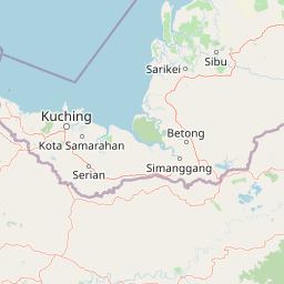
Map view of Kuching Wetlands National Park

Use this park location map to pinpoint Kuching Wetlands National Park in Malaysia, understand its exact geographic position, and read its mapped placement within the surrounding landscape more clearly.

Pigeon | © OpenStreetMap contributors

Location context for Kuching Wetlands National Park

Sarawak
Park atlas

Mapped Protected Landscapes: Trace the regional spread of national parks and coastal wetlands across Sarawak, Malaysian Borneo.

Find More National Parks and Protected Areas Near Kuching Wetlands National Park
Explore other national parks and protected areas near Kuching Wetlands National Park, including diverse coastal wetlands and tropical forest landscapes across Sarawak, Malaysian Borneo. Compare these regional park geographies to trace the spread of conservation efforts and discover adjacent protected areas beyond this important Ramsar site.
National parkSarawak

Kubah National Park: National Park Status and Mapped Landscape in Sarawak

Explore its protected boundaries and geographic context within Borneo.

Kubah National Park is a protected national park located in Sarawak, Malaysia, representing a crucial element of the region's conservation landscape. This detailed entry focuses on its identity as a national park, its specific geographic placement within Sarawak, and its significance for map-based exploration. Users can investigate the mapped boundaries and understand how Kubah National Park fits into the larger atlas of protected areas in East Malaysia, providing a factual foundation for geographic discovery without travel advice.

Area
22.3 km²
Established
1989
IUCN
II
Visitors
45K annual
National parkSarawak

Santubong National Park: Sarawak's Protected Landscape for Geographic Atlas Exploration

Mapped park boundaries and regional terrain context in Borneo

Delve into Santubong National Park, a significant protected area situated within the diverse geography of Sarawak, Malaysia. This resource provides detailed information on the park's mapped boundaries, allowing for focused exploration of its specific terrain and its role within the regional protected landscape atlas. Understand the geographic identity of Santubong National Park and its contribution to Borneo's conservation mapping.

Area
14.1 km²
Established
2007
IUCN
II
Relief
Mountain
National parkSarawak

Talang Satang National Park: Protected Landscape and Sarawak Geography

Explore its mapped boundaries and regional context.

Delve into the protected landscape of Talang Satang National Park, a key national park situated in the dynamic geography of Sarawak, Malaysia. This entry provides essential context for understanding its specific protected boundaries and its contribution to the broader regional natural landscape. Discover its atlas-relevant details to enrich your understanding of Borneo's protected areas and their geographic distribution.

Area
194.14 km²
Established
1999
IUCN
II
Relief
Lowland
Watercolor illustration of a coastal landscape with a distinctive rock formation, green vegetation, and calm water under a soft sky with distant mountains
National parkKuching Division

Bako National Park: Sarawak's Oldest National Park and Coastal Protected Landscape

Explore diverse ecosystems and dramatic mapped geology near Kuching Division.

Bako National Park, the oldest national park in Sarawak, Malaysia, offers a profound study in ecological concentration and geological drama. Covering a mere 27 square kilometers on the Muara Tebas peninsula, it encapsulates seven distinct ecosystem types, from coastal heath forest to mangrove areas, supporting significant biodiversity. The park's protected landscape is defined by its stunning sandstone coastline, carved by the sea into cliffs, arches, and seastacks, providing a unique geographic context. This makes Bako an essential destination for understanding Borneo's environmental diversity and the mapped boundaries of its conservation areas.

Area
27.27 km²
Established
1957
IUCN
II
Relief
Mixed relief
National parkSarawak

Gunung Gading National Park: Sarawak's Protected Landscape and Geographic Context

Discover mapped terrain and protected area boundaries.

Gunung Gading National Park is an important national park located in Sarawak, Malaysia, offering critical insights into the region's geography and protected lands. This park serves as a key entity for exploring its specific mapped terrain and understanding its place within the diverse landscapes of Borneo. Examining Gunung Gading National Park aids in comprehending the distribution and character of protected areas in East Malaysia through a structured, atlas-oriented approach.

Area
43.6 km²
Established
1983
IUCN
II
Relief
Mountain
National parkKuching Division

Tanjung Datu National Park: Protected Landscape and Regional Geography

Explore its mapped boundaries within Kuching Division.

Tanjung Datu National Park is a protected natural area offering insight into regional conservation and geographic patterns within Malaysia. This entry provides a detailed look at the park's identity as a national park, focusing on its mapped boundaries and its contribution to the broader landscape context of the Kuching Division. It is designed for users seeking structured information about protected areas and their geographical distribution.

Area
7.3 km²
Established
1994
IUCN
II
Climate
Tropical
National parkMalaysia

Maludam National Park: Southeast Asian Protected Landscape and National Park Geography

Mapped boundaries and natural terrain in Malaysia.

Maludam National Park offers a focused exploration of protected landscape identity and geographic context within Malaysia. As a designated national park, it serves as a vital component for understanding the distribution of protected areas and their mapped terrain. This detailed entry allows for an appreciation of the park's specific environmental character and its contribution to the broader atlas of natural landscapes in Southeast Asia, facilitating structured discovery for researchers and explorers.

Area
432 km²
Established
2000
IUCN
II
Relief
Lowland
National parkSarawak

Rajang Mangroves National Park: Borneo's Premier Mangrove Protected Landscape

Explore the mapped geography and wetland conservation of this Sarawak national park.

Rajang Mangroves National Park is a significant protected area dedicated to preserving the intricate mangrove swamp ecosystems of Sarawak's Rajang River delta. Encompassing a vast expanse of tidal channels and riverine forests, this national park serves as a critical habitat for unique wildlife and plays a vital role in coastal ecological health. Its landscape is defined by the dynamic interface between riverine and marine environments, offering a prime example of wetland conservation within Borneo's broader natural geography and atlas context.

Area
107 km²
Established
2000
IUCN
II
Relief
Lowland

Common questions about visiting, size, designation, and location context for Kuching Wetlands National Park

Kuching Wetlands National Park FAQs for park facts, access, geography, and protected area context
Find quick answers about Kuching Wetlands National Park, including protected-area facts, park geography, trail and visitor context, and how the park fits into its surrounding country and regional landscape.
MoriAtlas Explorer

Continue Your Protected Areas Search Across the Global Atlas

Deepen your exploration by continuing the structured search for national parks and protected areas worldwide. Utilize the comprehensive filtering capabilities to compare different conservation landscapes and refine your understanding of global park geography. Discover more about the distribution and characteristics of protected natural areas.

Global natural geography