

Mori Atlas logo
National parkGunung Gading National Park

Understand the geographic boundaries and mapped natural terrain of this national park.

Gunung Gading National Park: A Protected Landscape within Sarawak, Malaysia

Gunung Gading National Park represents a significant protected landscape within the Malaysian state of Sarawak on the island of Borneo. This national park offers an essential point for atlas-driven discovery, allowing users to explore its specific geographic setting and mapped natural terrain. Understanding Gunung Gading National Park provides valuable context for the distribution of protected areas across East Malaysia and the broader island of Borneo, showcasing its unique regional geography.

Lowland RainforestRafflesia ConservationDipterocarp ForestWaterfall TrailsTropical NatureGranite Hills

Gunung Gading National Park

National park

Park overview

Structured park overview, official facts, and landscape profile for Gunung Gading National Park

Gunung Gading National Park park facts, protected area profile, and essential visitor context
Review the core facts for Gunung Gading National Park, including designation, size, terrain, visitor scale, habitats, and operating context in one park-focused overview.

About Gunung Gading National Park

Gunung Gading National Park represents one of Borneo's most significant protected areas for lowland and hill rainforest conservation. Located near the westernmost point of the island in southwest Sarawak, the park encompasses approximately 43 square kilometers of tropical forest ecosystem that once dominated northwest Borneo but now survives only in isolated fragments. The park's landscape is characterized by granite slopes and mixed dipterocarp forest, with two main hills forming the topographic core of the protected area. A network of marked trails traverses the forested slopes, following streams to a series of waterfalls, with the Waterfall Trail culminating at the seventh and final cascade. The park is easily accessible from Kuching via a scenic road that passes through agricultural land and crosses rivers before arriving at the park entrance near Lundu town. The combination of elevation variation, underlying geology, and diverse relief creates distinctive forest communities within a relatively compact area, making it a valuable destination for nature enthusiasts and researchers interested in Borneo's tropical forest biodiversity.

Quick facts and research context for Gunung Gading National Park

Gunung Gading National Park is located approximately 75 kilometers southwest of Kuching in Sarawak, Malaysia, near the westernmost point of Borneo. The park was established in 1983 and covers around 43.6 square kilometers of protected rainforest. It is managed by the Sarawak Forestry Corporation and is notable for protecting Rafflesia tuan-mudae, one of the world's largest and most endangered flowering plants. The park features two main hills, a challenging six-hour round-trip summit trail, and a Waterfall Trail that passes through seven cascades. A visitor center at the park headquarters is modeled after a traditional Bidayuh head-house.

Park context

Deeper park guide and search-rich context for Gunung Gading National Park

Gunung Gading National Park history, landscape, wildlife, and travel context
Explore Gunung Gading National Park through its history, landscape character, ecosystems, wildlife, conservation priorities, cultural context, and seasonal travel timing in a structured park guide built for atlas discovery and search intent.

Why Gunung Gading National Park stands out

Gunung Gading National Park is best known for being one of the few locations in Borneo where the massive Rafflesia tuan-mudae can be observed in bloom. This parasitic flowering plant produces the largest individual flower in the world, and the park was established specifically to protect this endangered species and its habitat. The park also hosts Amorphophallus titanum, the Titan arum, another massive and rare plant species that blooms even less frequently than Rafflesia. Beyond these botanical highlights, the park protects significant tracts of lowland and hill dipterocarp rainforest in a region where such forest has otherwise been largely cleared.

Gunung Gading National Park history and protected-area timeline

Gunung Gading National Park was established in 1983 with the explicit purpose of protecting Rafflesia tuan-mudae, one of the world's largest and most endangered flowering plants. The establishment was driven by the need to conserve both the rare plant species and its surrounding habitat in the face of increasing threats to Borneo's lowland forests. Initially, the park received minimal visitation from international tourists and served primarily as a domestic destination. The development of park facilities in the mid-1990s sparked increased interest among Malaysian tourists, with visitor numbers peaking in 1995. Although tourism declined in subsequent years, the park has since experienced gradual growth in international visitors. A visitor center was constructed at the park headquarters, designed to resemble a traditional Bidayuh head-house, serving as an educational facility for conservation awareness and housing exhibits related to Rafflesia and the park's ecological significance.

Gunung Gading National Park landscape and geographic character

The landscape of Gunung Gading National Park is defined by its hilly tropical rainforest terrain centered on granite slopes and valleys. The park contains two main hills, with Gunung Gading itself forming the prominent feature that gives the park its name. The terrain rises from the lower forested areas through steep slopes to the hill summits, creating a varied topography within a relatively compact area. The underlying granite geology contributes to the park's distinctive character and influences the soil and moisture conditions that support the forest ecosystem. A series of streams descend through the park, cascading over rock formations to create multiple waterfalls, with the Waterfall Trail providing access to seven distinct cascades. The surrounding landscape beyond the park boundary includes agricultural land and coastal areas near Lundu, with the park representing a preserved core of natural forest amid a modified landscape.

Gunung Gading National Park ecosystems, habitats, and plant life

Gunung Gading National Park protects a representative example of Borneo's lowland and hill dipterocarp rainforest ecosystem, an environment that has been dramatically reduced across its former range in northwest Borneo. The forest here supports a complex community of plant species adapted to the tropical conditions, with the dipterocarp family dominating the canopy. Beyond the commercially important dipterocarp trees, the forest contains a rich understory and diverse plant life that characterizes healthy tropical rainforest. The park is particularly notable for two remarkable plant species: Rafflesia tuan-mudae, a massive parasitic flowering plant that produces the world's largest flower, and Amorphophallus titanum, the Titan arum, which produces one of the world's largest unbranched flower structures. Both species bloom infrequently and unpredictably, making sightings rare and special occasions that park rangers work to communicate to visitors when conditions arise.

Gunung Gading National Park wildlife and species highlights

While the Wikipedia source emphasizes the park's botanical treasures, particularly Rafflesia and Titan arum, the park's rainforest environment supports a diversity of animal life typical of Borneo's lowland forests. The forest provides habitat for numerous species of birds, insects, and other wildlife adapted to the tropical ecosystem. The presence of streams and freshwater ponds within the park creates additional habitat diversity. The long-nosed horned frog, a distinctive amphibian species found in Borneo's rainforests, has been documented in the park. The park's protected status helps preserve habitat for wildlife in a region where lowland forest has been extensively cleared for agriculture and development.

Gunung Gading National Park conservation status and protection priorities

Gunung Gading National Park was established specifically for the conservation of Rafflesia tuan-mudae, highlighting the species' endangered status and the urgency of protecting its habitat. The park represents one of the more extensive remaining fragments of the lowland and hill rainforest that once covered all of northwest Borneo, making it significant for regional conservation. The protection of this forest ecosystem also benefits the broader community of species that depend on these habitats, from rare plants to various animal species. The park's management by the Sarawak Forestry Corporation includes conservation education efforts through the visitor center, which houses exhibits about Rafflesia and the park's ecological significance. The unpredictable nature of Rafflesia flowering creates conservation challenges, as the species requires specific conditions to bloom, and park staff coordinate with travel agencies to inform visitors when flowering events are anticipated.

Gunung Gading National Park cultural meaning and human context

Gunung Gading National Park is located in Sarawak near the town of Lundu, a region with indigenous Bidayuh communities. The park's visitor center was designed to resemble a traditional Bidayuh head-house, reflecting the cultural heritage of the local area. The Bidayuh are one of the indigenous peoples of Sarawak, and their traditional architectural styles have been incorporated into the park's facilities as a way to acknowledge and honor the local cultural context. The park's setting near Lundu places it within a landscape where human communities have traditionally interacted with the forest environment, though the protected area itself is now managed primarily for conservation and nature-based recreation.

Top sights and standout views in Gunung Gading National Park

Gunung Gading National Park offers several distinctive highlights that set it apart among Borneo's protected areas. The opportunity to observe Rafflesia tuan-mudae in bloom represents the park's most famous attraction, drawing visitors interested in witnessing one of the world's most remarkable plant species. The Waterfall Trail through seven cascades provides a scenic hiking experience through pristine forest. The summit trail to the top of Gunung Gading presents a more challenging trek for those seeking broader views of the surrounding landscape. The relatively compact size of the park makes it accessible for day trips from Kuching while still offering substantial natural experience. The chance to see Titan arum, another massive and rare flowering plant, adds to the botanical significance of the park.

Best time to visit Gunung Gading National Park

The best time to visit Gunung Gading National Park coincides with the dry season in Sarawak, typically from March through October, when conditions are more favorable for hiking the forest trails. However, Rafflesia flowering is inherently unpredictable and can occur at various times throughout the year, not following seasonal patterns. Park rangers monitor flowering conditions and notify travel agencies when blooms are expected, allowing visitors to potentially time their visits accordingly. The wet season from November to February brings higher rainfall, which can affect trail conditions and visibility but also contributes to the lush forest environment. Year-round visitation is possible, though visitors interested in specific botanical highlights should coordinate with park authorities or local tour operators to inquire about current flowering conditions.

Park location guide

Geography guide, regional context, and park location map for Gunung Gading National Park

Gunung Gading National Park park geography, regions, and map view in Malaysia
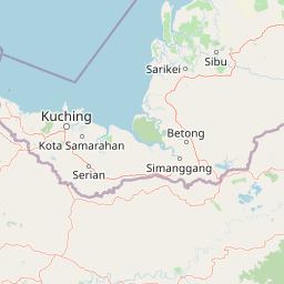
Understand where Gunung Gading National Park sits in Malaysia through a broader geographic reading of the surrounding landscape, nearby location context, and its mapped position within the national park landscape.

How Gunung Gading National Park fits into Malaysia

Malaysia is a federal constitutional monarchy located in Southeast Asia. The country consists of 13 states and three federal territories, divided by the South China Sea into Peninsular Malaysia on the Indochinese Peninsula and East Malaysia on the island of Borneo. With a population of over 34 million, it achieved independence from Britain in 1957 and became a modern federation in 1963. The country is recognized for its multicultural population, tropical climate, and significant economic role in the region.

Wider geography shaping Gunung Gading National Park in Malaysia

Malaysia occupies a strategic position in Southeast Asia, split by the South China Sea into two distinct regions. Peninsular Malaysia lies on the Indochinese Peninsula, sharing a land border with Thailand to the north and maritime borders with Singapore, Vietnam, and Indonesia. East Malaysia occupies the northern portion of Borneo, sharing land borders with Brunei and Indonesia, and maritime borders with the Philippines and Vietnam. The country's terrain includes coastal plains, mountain ranges such as the Titiwangsa in the peninsula, and extensive tropical rainforests.

Map view of Gunung Gading National Park

Use this park location map to pinpoint Gunung Gading National Park in Malaysia, understand its exact geographic position, and read its mapped placement within the surrounding landscape more clearly.

Pigeon | © OpenStreetMap contributors

Location context for Gunung Gading National Park

Sarawak
Park atlas

Compare surrounding protected landscapes and regional park geography for continued Borneo rainforest discovery.

Explore Nearby National Parks and Protected Areas Beyond Gunung Gading National Park
After exploring Gunung Gading National Park's unique Rafflesia habitat and waterfall trails, browse other national parks and protected areas in the surrounding Borneo region. Continue your atlas-based journey to compare diverse rainforest ecosystems and conservation landscapes across Sarawak, charting contiguous protected zones and unique natural features.
National parkSarawak

Talang Satang National Park: Protected Landscape and Sarawak Geography

Explore its mapped boundaries and regional context.

Delve into the protected landscape of Talang Satang National Park, a key national park situated in the dynamic geography of Sarawak, Malaysia. This entry provides essential context for understanding its specific protected boundaries and its contribution to the broader regional natural landscape. Discover its atlas-relevant details to enrich your understanding of Borneo's protected areas and their geographic distribution.

Area
194.14 km²
Established
1999
IUCN
II
Relief
Lowland
National parkSarawak

Kubah National Park: National Park Status and Mapped Landscape in Sarawak

Explore its protected boundaries and geographic context within Borneo.

Kubah National Park is a protected national park located in Sarawak, Malaysia, representing a crucial element of the region's conservation landscape. This detailed entry focuses on its identity as a national park, its specific geographic placement within Sarawak, and its significance for map-based exploration. Users can investigate the mapped boundaries and understand how Kubah National Park fits into the larger atlas of protected areas in East Malaysia, providing a factual foundation for geographic discovery without travel advice.

Area
22.3 km²
Established
1989
IUCN
II
Visitors
45K annual
National parkKuching Division

Tanjung Datu National Park: Protected Landscape and Regional Geography

Explore its mapped boundaries within Kuching Division.

Tanjung Datu National Park is a protected natural area offering insight into regional conservation and geographic patterns within Malaysia. This entry provides a detailed look at the park's identity as a national park, focusing on its mapped boundaries and its contribution to the broader landscape context of the Kuching Division. It is designed for users seeking structured information about protected areas and their geographical distribution.

Area
7.3 km²
Established
1994
IUCN
II
Climate
Tropical
National parkSarawak

Kuching Wetlands National Park: Sarawak's Protected National Park Landscape and Geography

Explore the mapped wetland boundaries and regional context.

Gain a structured understanding of Kuching Wetlands National Park, a key protected area in Sarawak, Malaysia. This detailed entry provides insights into its specific geographic identity, mapped park boundaries, and its significance as a national park within the Borneo region's extensive natural landscapes. Discover the atlas value of this protected wetland environment for comprehensive geographic exploration.

Area
84.95 km²
Established
1992
IUCN
II
Relief
Lowland
National parkSarawak

Santubong National Park: Sarawak's Protected Landscape for Geographic Atlas Exploration

Mapped park boundaries and regional terrain context in Borneo

Delve into Santubong National Park, a significant protected area situated within the diverse geography of Sarawak, Malaysia. This resource provides detailed information on the park's mapped boundaries, allowing for focused exploration of its specific terrain and its role within the regional protected landscape atlas. Understand the geographic identity of Santubong National Park and its contribution to Borneo's conservation mapping.

Area
14.1 km²
Established
2007
IUCN
II
Relief
Mountain
Watercolor illustration of a coastal landscape with a distinctive rock formation, green vegetation, and calm water under a soft sky with distant mountains
National parkKuching Division

Bako National Park: Sarawak's Oldest National Park and Coastal Protected Landscape

Explore diverse ecosystems and dramatic mapped geology near Kuching Division.

Bako National Park, the oldest national park in Sarawak, Malaysia, offers a profound study in ecological concentration and geological drama. Covering a mere 27 square kilometers on the Muara Tebas peninsula, it encapsulates seven distinct ecosystem types, from coastal heath forest to mangrove areas, supporting significant biodiversity. The park's protected landscape is defined by its stunning sandstone coastline, carved by the sea into cliffs, arches, and seastacks, providing a unique geographic context. This makes Bako an essential destination for understanding Borneo's environmental diversity and the mapped boundaries of its conservation areas.

Area
27.27 km²
Established
1957
IUCN
II
Relief
Mixed relief
National parkMalaysia

Maludam National Park: Southeast Asian Protected Landscape and National Park Geography

Mapped boundaries and natural terrain in Malaysia.

Maludam National Park offers a focused exploration of protected landscape identity and geographic context within Malaysia. As a designated national park, it serves as a vital component for understanding the distribution of protected areas and their mapped terrain. This detailed entry allows for an appreciation of the park's specific environmental character and its contribution to the broader atlas of natural landscapes in Southeast Asia, facilitating structured discovery for researchers and explorers.

Area
432 km²
Established
2000
IUCN
II
Relief
Lowland
National parkSarawak

Rajang Mangroves National Park: Borneo's Premier Mangrove Protected Landscape

Explore the mapped geography and wetland conservation of this Sarawak national park.

Rajang Mangroves National Park is a significant protected area dedicated to preserving the intricate mangrove swamp ecosystems of Sarawak's Rajang River delta. Encompassing a vast expanse of tidal channels and riverine forests, this national park serves as a critical habitat for unique wildlife and plays a vital role in coastal ecological health. Its landscape is defined by the dynamic interface between riverine and marine environments, offering a prime example of wetland conservation within Borneo's broader natural geography and atlas context.

Area
107 km²
Established
2000
IUCN
II
Relief
Lowland

Common questions about visiting, size, designation, and location context for Gunung Gading National Park

Gunung Gading National Park FAQs for park facts, access, geography, and protected area context
Find quick answers about Gunung Gading National Park, including protected-area facts, park geography, trail and visitor context, and how the park fits into its surrounding country and regional landscape.
MoriAtlas Explorer

Continue Your Protected Areas Search Across the Global Atlas

Deepen your exploration by continuing the structured search for national parks and protected areas worldwide. Utilize the comprehensive filtering capabilities to compare different conservation landscapes and refine your understanding of global park geography. Discover more about the distribution and characteristics of protected natural areas.

Global natural geography