

Mori Atlas logo
National parkMaludam National Park

Discover the mapped boundaries and natural terrain of this national park in Southeast Asia.

Maludam National Park: Explore Malaysia's Protected Landscape and Geography

(Taman Negara Maludam)

Maludam National Park represents a significant protected landscape within Malaysia, offering a focused lens for geographic and atlas exploration. This national park provides a distinct entry point for understanding protected areas and their place within regional geography. Users can delve into the mapped boundaries and natural terrain of Maludam National Park, appreciating its role as a component of Malaysia's diverse natural heritage and conservation efforts.

Peat Swamp ForestPrimatesRed Banded LangurProboscis MonkeyBorneoSarawak

Maludam National Park

National park

Park overview

Structured park overview, official facts, and landscape profile for Maludam National Park

Maludam National Park park facts, protected area profile, and essential visitor context
Review the core facts for Maludam National Park, including designation, size, terrain, visitor scale, habitats, and operating context in one park-focused overview.

About Maludam National Park

Maludam National Park occupies the Maludam Peninsula in southeastern Sarawak, protecting a landscape of remarkable ecological significance that has survived relatively intact while surrounding lowland forests have been extensively cleared. The park's terrain is uniformly low-lying and flat, characterized by the distinctive hydrology of peat swamp forests where organic matter accumulates over millennia in waterlogged conditions. This habitat supports a specialized ecosystem adapted to acidic soils, seasonal flooding, and the unique challenges of peat-based environments. The park was created to safeguard what remains of Sarawak's peat swamp forests, which have been dramatically reduced across the state by logging and agricultural conversion. Maludam represents the largest and most significant remaining block of this habitat type, serving as a refuge for species that depend on the complex structure of mature peat swamp forest. Despite its ecological importance, the park currently lacks visitor facilities and remains closed to the public, reflecting both its remote location and the priority placed on conservation management over tourism.

Quick facts and research context for Maludam National Park

Maludam National Park covers 432 square kilometers in Betong Division, Sarawak, on the island of Borneo. The park was established in 2000 and is managed by the Sarawak Forestry Department. It protects the largest remaining tract of peat swamp forest in Sarawak and Brunei. The park contains the world's only viable population of the red banded langur, a critically endangered primate endemic to Borneo. It also supports one of only five viable populations of proboscis monkeys in Sarawak.

Park context

Deeper park guide and search-rich context for Maludam National Park

Maludam National Park history, landscape, wildlife, and travel context
Explore Maludam National Park through its history, landscape character, ecosystems, wildlife, conservation priorities, cultural context, and seasonal travel timing in a structured park guide built for atlas discovery and search intent.

Why Maludam National Park stands out

Maludam National Park is best known for its vast intact peat swamp forest ecosystem and its remarkable population of the red banded langur, a striking primate found nowhere else on Earth. The park also supports significant populations of proboscis monkeys, the charismatic primates with distinctive elongated noses. These two primate species, along with the silvery lutung, represent the park's most notable mammalian residents. The birdlife is equally impressive, with populations of hornbills, kingfishers, and the rare Storm's stork inhabiting the canopy and waterway margins.

Maludam National Park history and protected-area timeline

Maludam National Park was established in 2000 through the Sarawak Forestry Department, becoming the second-largest national park in the state after Pulung Tau National Park. The creation of the park represented a recognition of the critical conservation value of Sarawak's remaining peat swamp forests, which had been extensively exploited throughout the late twentieth century. The establishment came during a period of increasing environmental awareness in Malaysia regarding the loss of lowland forest habitats and the species they support. Proposals have been advanced to expand the park's boundaries further, though these remain under consideration. The park's management falls under the jurisdiction of the Sarawak Forestry Department, which oversees its protection and monitoring programs.

Maludam National Park landscape and geographic character

The landscape of Maludam National Park is defined by its complete coverage of peat swamp forest, a distinctive ecosystem characterized by waterlogged conditions, acidic peat soils, and a canopy dominated by dipterocarp trees adapted to these challenging conditions. The terrain is uniformly flat, with elevation varying only slightly across the park's extensive area. The peat layer itself represents accumulated organic material from thousands of years of plant decomposition in the saturated environment, creating a substrate that stores significant amounts of carbon. The forest structure includes emergents rising above the main canopy, with an understory adapted to the low light conditions and a ground layer of ferns, palms, and other moisture-loving plants. Water channels and seasonal floodplains traverse the landscape, providing wet-season drainage and habitat diversity.

Maludam National Park ecosystems, habitats, and plant life

The peat swamp forest ecosystem of Maludam National Park represents one of Borneo's most distinctive and threatened habitat types. These forests once covered extensive areas of Sarawak's lowlands but have been largely cleared, making the park's intact coverage critically important for biodiversity conservation. The ecosystem supports specialized plant species adapted to the acidic, waterlogged conditions, including various dipterocarps, palms, and ferns that form the structural foundation of the forest. The park's significance extends beyond its borders as the largest remaining patch of this habitat type in the region, serving as a reservoir of biodiversity that cannot be found elsewhere in such a concentrated form. The complex canopy structure and the presence of water channels create microhabitats that support a range of ecological interactions.

Maludam National Park wildlife and species highlights

Maludam National Park hosts an extraordinary concentration of primate species that depend on the peat swamp forest habitat. The park contains the world's only viable population of the red banded langur, a beautiful monkey species endemic to Borneo whose remaining range is restricted to the peat swamp forests of Sarawak's Sri Aman and Sarikei divisions. This makes the park globally significant for the conservation of this species. Additionally, the park supports one of approximately five viable populations of proboscis monkeys in Sarawak, these distinctive primates with their remarkable elongated noses finding ideal habitat in the forest canopy. The silvery lutung is also present in significant numbers. Bird diversity is notably higher than mammal diversity, with hornbill species including the black hornbill, oriental pied hornbill, and rhinoceros hornbill among the most prominent inhabitants. Kingfishers such as the blue-eared and stork-billed varieties are common along waterways, while the rare Storm's stork occasionally appears in the park.

Maludam National Park conservation status and protection priorities

Maludam National Park represents a critical conservation stronghold for Borneo peat swamp forest ecosystems and the species that depend on them. The park protects the largest remaining tract of this habitat type in Sarawak and Brunei, making it essential for regional biodiversity preservation. The presence of the only viable population of red banded langurs globally gives the park extraordinary significance for primate conservation, as the survival of this species depends fundamentally on the protection of its remaining habitat. The proboscis monkey populations represent another conservation priority, as these animals have been reduced across their range by habitat loss. The peat swamp forest itself serves important ecological functions including carbon storage and water regulation, adding environmental significance beyond species conservation.

Maludam National Park cultural meaning and human context

Maludam National Park occupies the traditional territory of indigenous communities in the Betong Division of Sarawak. The Maludam Peninsula has been inhabited by various Dayak groups whose relationship with the peat swamp forest extends across generations. These communities have historically utilized the forest's resources while maintaining the ecological processes that sustain the ecosystem. The park's establishment in 2000 came after periods of significant logging pressure on Sarawak's lowland forests, reflecting both the ecological importance of the area and the broader movement toward protected area establishment in Malaysian Borneo.

Top sights and standout views in Maludam National Park

Maludam National Park stands as the largest remaining peat swamp forest in Sarawak and Brunei, preserving a critically endangered ecosystem that has been largely eliminated from the surrounding landscape. The park shelters the world's sole viable population of the red banded langur, an endemic primate of extraordinary conservation importance. Proboscis monkeys thrive here in one of only five remaining viable populations in Sarawak, while the canopy supports diverse hornbill species and occasional Storm's stork. This combination of unique primate populations and intact peat swamp habitat makes Maludam one of the most significant conservation areas in Borneo.

Best time to visit Maludam National Park

Maludam National Park is currently not open to visitors and has no visitor facilities. The park remains under management for conservation purposes, with access restricted to protect both the wildlife populations and the intact ecosystem. Those interested in experiencing peat swamp forest and Borneo's wildlife should consider other Sarawak protected areas that welcome visitors, such as Bako National Park or Semenggoh Wildlife Centre.

Park location guide

Geography guide, regional context, and park location map for Maludam National Park

Maludam National Park park geography, regions, and map view in Malaysia
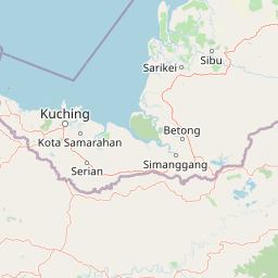
Understand where Maludam National Park sits in Malaysia through a broader geographic reading of the surrounding landscape, nearby location context, and its mapped position within the national park landscape.

How Maludam National Park fits into Malaysia

Malaysia is a federal constitutional monarchy located in Southeast Asia. The country consists of 13 states and three federal territories, divided by the South China Sea into Peninsular Malaysia on the Indochinese Peninsula and East Malaysia on the island of Borneo. With a population of over 34 million, it achieved independence from Britain in 1957 and became a modern federation in 1963. The country is recognized for its multicultural population, tropical climate, and significant economic role in the region.

Wider geography shaping Maludam National Park in Malaysia

Malaysia occupies a strategic position in Southeast Asia, split by the South China Sea into two distinct regions. Peninsular Malaysia lies on the Indochinese Peninsula, sharing a land border with Thailand to the north and maritime borders with Singapore, Vietnam, and Indonesia. East Malaysia occupies the northern portion of Borneo, sharing land borders with Brunei and Indonesia, and maritime borders with the Philippines and Vietnam. The country's terrain includes coastal plains, mountain ranges such as the Titiwangsa in the peninsula, and extensive tropical rainforests.

Map view of Maludam National Park

Use this park location map to pinpoint Maludam National Park in Malaysia, understand its exact geographic position, and read its mapped placement within the surrounding landscape more clearly.

Pigeon | © OpenStreetMap contributors

Location context for Maludam National Park

Sarawak
Park atlas

Explore protected landscapes across Sarawak and Borneo, comparing peat swamp forests and primate habitats for regional context.

Discover Other National Parks and Protected Areas Near Maludam National Park in Borneo
Discover additional national parks and protected areas geographically connected to Maludam National Park, highlighting Borneo's vital peat swamp forests and primate habitats. Comparing these regional protected landscapes reveals the spread of endangered ecosystems and illuminates broader conservation efforts across Sarawak.
National parkSarawak

Rajang Mangroves National Park: Borneo's Premier Mangrove Protected Landscape

Explore the mapped geography and wetland conservation of this Sarawak national park.

Rajang Mangroves National Park is a significant protected area dedicated to preserving the intricate mangrove swamp ecosystems of Sarawak's Rajang River delta. Encompassing a vast expanse of tidal channels and riverine forests, this national park serves as a critical habitat for unique wildlife and plays a vital role in coastal ecological health. Its landscape is defined by the dynamic interface between riverine and marine environments, offering a prime example of wetland conservation within Borneo's broader natural geography and atlas context.

Area
107 km²
Established
2000
IUCN
II
Relief
Lowland
Watercolor illustration of a coastal landscape with a distinctive rock formation, green vegetation, and calm water under a soft sky with distant mountains
National parkKuching Division

Bako National Park: Sarawak's Oldest National Park and Coastal Protected Landscape

Explore diverse ecosystems and dramatic mapped geology near Kuching Division.

Bako National Park, the oldest national park in Sarawak, Malaysia, offers a profound study in ecological concentration and geological drama. Covering a mere 27 square kilometers on the Muara Tebas peninsula, it encapsulates seven distinct ecosystem types, from coastal heath forest to mangrove areas, supporting significant biodiversity. The park's protected landscape is defined by its stunning sandstone coastline, carved by the sea into cliffs, arches, and seastacks, providing a unique geographic context. This makes Bako an essential destination for understanding Borneo's environmental diversity and the mapped boundaries of its conservation areas.

Area
27.27 km²
Established
1957
IUCN
II
Relief
Mixed relief
National parkSarawak

Santubong National Park: Sarawak's Protected Landscape for Geographic Atlas Exploration

Mapped park boundaries and regional terrain context in Borneo

Delve into Santubong National Park, a significant protected area situated within the diverse geography of Sarawak, Malaysia. This resource provides detailed information on the park's mapped boundaries, allowing for focused exploration of its specific terrain and its role within the regional protected landscape atlas. Understand the geographic identity of Santubong National Park and its contribution to Borneo's conservation mapping.

Area
14.1 km²
Established
2007
IUCN
II
Relief
Mountain
National parkSarawak

Kuching Wetlands National Park: Sarawak's Protected National Park Landscape and Geography

Explore the mapped wetland boundaries and regional context.

Gain a structured understanding of Kuching Wetlands National Park, a key protected area in Sarawak, Malaysia. This detailed entry provides insights into its specific geographic identity, mapped park boundaries, and its significance as a national park within the Borneo region's extensive natural landscapes. Discover the atlas value of this protected wetland environment for comprehensive geographic exploration.

Area
84.95 km²
Established
1992
IUCN
II
Relief
Lowland
National parkSri Aman Division

Batang Ai National Park: National Park Landscape and Geographic Discovery

Explore the protected terrain and mapped boundaries of Sri Aman Division.

Batang Ai National Park serves as a distinct national park entity, vital for understanding the protected landscape and regional geography of Malaysia's Sri Aman Division. This resource offers detailed insights into the park's geographic scope, its mapped boundaries, and the natural terrain it encompasses, enabling structured exploration for atlas enthusiasts and geography researchers.

Area
24 km²
Established
1991
IUCN
II
Relief
Lowland
National parkSarawak

Kubah National Park: National Park Status and Mapped Landscape in Sarawak

Explore its protected boundaries and geographic context within Borneo.

Kubah National Park is a protected national park located in Sarawak, Malaysia, representing a crucial element of the region's conservation landscape. This detailed entry focuses on its identity as a national park, its specific geographic placement within Sarawak, and its significance for map-based exploration. Users can investigate the mapped boundaries and understand how Kubah National Park fits into the larger atlas of protected areas in East Malaysia, providing a factual foundation for geographic discovery without travel advice.

Area
22.3 km²
Established
1989
IUCN
II
Visitors
45K annual
National parkSarawak

Talang Satang National Park: Protected Landscape and Sarawak Geography

Explore its mapped boundaries and regional context.

Delve into the protected landscape of Talang Satang National Park, a key national park situated in the dynamic geography of Sarawak, Malaysia. This entry provides essential context for understanding its specific protected boundaries and its contribution to the broader regional natural landscape. Discover its atlas-relevant details to enrich your understanding of Borneo's protected areas and their geographic distribution.

Area
194.14 km²
Established
1999
IUCN
II
Relief
Lowland
National parkSarawak

Gunung Gading National Park: Sarawak's Protected Landscape and Geographic Context

Discover mapped terrain and protected area boundaries.

Gunung Gading National Park is an important national park located in Sarawak, Malaysia, offering critical insights into the region's geography and protected lands. This park serves as a key entity for exploring its specific mapped terrain and understanding its place within the diverse landscapes of Borneo. Examining Gunung Gading National Park aids in comprehending the distribution and character of protected areas in East Malaysia through a structured, atlas-oriented approach.

Area
43.6 km²
Established
1983
IUCN
II
Relief
Mountain

Common questions about visiting, size, designation, and location context for Maludam National Park

Maludam National Park FAQs for park facts, access, geography, and protected area context
Find quick answers about Maludam National Park, including protected-area facts, park geography, trail and visitor context, and how the park fits into its surrounding country and regional landscape.
MoriAtlas Explorer

Continue Your Protected Areas Search Across the Global Atlas

Deepen your exploration by continuing the structured search for national parks and protected areas worldwide. Utilize the comprehensive filtering capabilities to compare different conservation landscapes and refine your understanding of global park geography. Discover more about the distribution and characteristics of protected natural areas.

Global natural geography
