Mori Atlas logo
Protected areaLac de la Kompienga

A vital hydroelectric reservoir and wetland mosaic within the Sudano-Sahelian savanna of southeastern Burkina Faso

Lac de la Kompienga: Mapped Boundaries and Geographic Identity of this Ramsar Protected Area

Lac de la Kompienga represents a foundational hydroelectric reservoir and internationally recognized wetland situated in the Est Region of Burkina Faso. Formed by the impoundment of the Kompienga River, this landscape acts as a complex intersection of engineered energy infrastructure, diverse aquatic habitats, and surrounding dry woodland environments. The area serves as a critical hydrological node within the Volta Basin, where permanent water bodies contrast with the broader, gently rolling terrain of Kompienga Province.

artificial lakehydroelectric reservoirRamsar wetlandwetland conservationVolta BasinSudano-Sahelian savanna

Lac de la Kompienga

Protected area

Park overview

Structured park overview, official facts, and landscape profile for Lac de la Kompienga

Lac de la Kompienga park facts, protected area profile, and essential visitor context

Review the core facts for Lac de la Kompienga, including designation, size, terrain, visitor scale, habitats, and operating context in one park-focused overview.

About Lac de la Kompienga

Lac de la Kompienga occupies a transition zone in southeastern Burkina Faso where the Sudano-Sahelian climate meets the wetter conditions of the Volta Basin headwaters. The reservoir resulted from the construction of the Kompienga Dam, which was the first major hydroelectric dam on Burkina Faso's national territory. The dam was closed and the basin began filling in 1988, while the associated 14 MW hydroelectric station entered service in 1989, marking a milestone for the country's domestic electricity supply.

The lake lies mainly within Kompienga Province in the Est Region, and stretches across an evolving landscape that previously was characterized by dry savanna vegetation and seasonal watercourses draining toward the Oti and the broader Volta system. The Kompienga River itself is sometimes referred to in older or regional sources as the Oualé. By impounding this tributary, the project created a substantial standing body of water in a region where permanent lakes of such size are otherwise rare.

Beyond its energy function, the reservoir was envisioned and has developed as a multipurpose resource. Downstream irrigation, freshwater fisheries, livestock watering, transhumance corrals, and emerging tourism have all been part of the project's rationale. The lake has also acted as a catalyst for settlement and economic activity, drawing fishers, traders, and service providers from various parts of Burkina Faso and neighboring countries around its shores.

Ecologically, the reservoir and its shoreline zone gained formal recognition when the site was inscribed on the Ramsar List of Wetlands of International Importance in October 2009. This designation reflects the relevance of the open water, the fringing marshy and seasonally flooded areas, and the broader waterbird habitat complex that has developed within the otherwise dry regional setting. In that sense, Lac de la Kompienga is a hybrid landscape, where engineered infrastructure and ecological recovery intersect to create a significant regional feature.

Quick facts and research context for Lac de la Kompienga

Lac de la Kompienga is an artificial reservoir in the Est Region of southeastern Burkina Faso, primarily within Kompienga Province near the borders with Togo and Benin. It was created by the Kompienga Dam on the Kompienga River, part of the Oti sub-basin of the Volta Basin, with impoundment in 1988 and a 14 MW hydroelectric station commissioned in 1989.

Its surface area is commonly reported around 17,500 to 21,000 hectares depending on water level, with a total storage capacity in the order of two billion cubic meters. The site has been recognized internationally through its 2009 inscription on the Ramsar List of Wetlands of International Importance, reflecting its value for waterbirds, fisheries, and downstream water supply in the Volta system.

Protection and recognition

Terrestrial conservation framework and establishment records for Lac de la Kompienga

Lac de la Kompienga Protection Status and Designated Area History

Documented protection status and designation history for Lac de la Kompienga outline its establishment as a terrestrial protected area in 2009. Official records assemble management scope and recognized conservation frameworks to support systematic environmental research.

Protection details

Protection scope
Terrestrial
Designated year
2009
Transboundary protection
No
Park context

Deeper park guide and search-rich context for Lac de la Kompienga

Lac de la Kompienga history, landscape, wildlife, and travel context

Explore Lac de la Kompienga through its history, landscape character, ecosystems, wildlife, conservation priorities, cultural context, and seasonal travel timing in a structured park guide built for atlas discovery and search intent.

Why Lac de la Kompienga stands out

Lac de la Kompienga is best known as Burkina Faso's first large hydroelectric reservoir and as a designated Ramsar wetland in a predominantly dry West African setting. The lake combines engineered functions, including power generation and irrigation support, with ecological functions tied to its open water, fringing wetlands, and the dry savanna landscapes that surround it. The reservoir also stands out for its role in reshaping human geography in eastern Burkina Faso. The creation of the lake opened up an area that was previously relatively isolated, attracting fishers, traders, and new settlements from across the country and the wider region. The combination of energy infrastructure, a Ramsar-recognized wetland, and a newly created lake ecosystem in a Sudano-Sahelian environment gives the site a distinctive and layered identity.
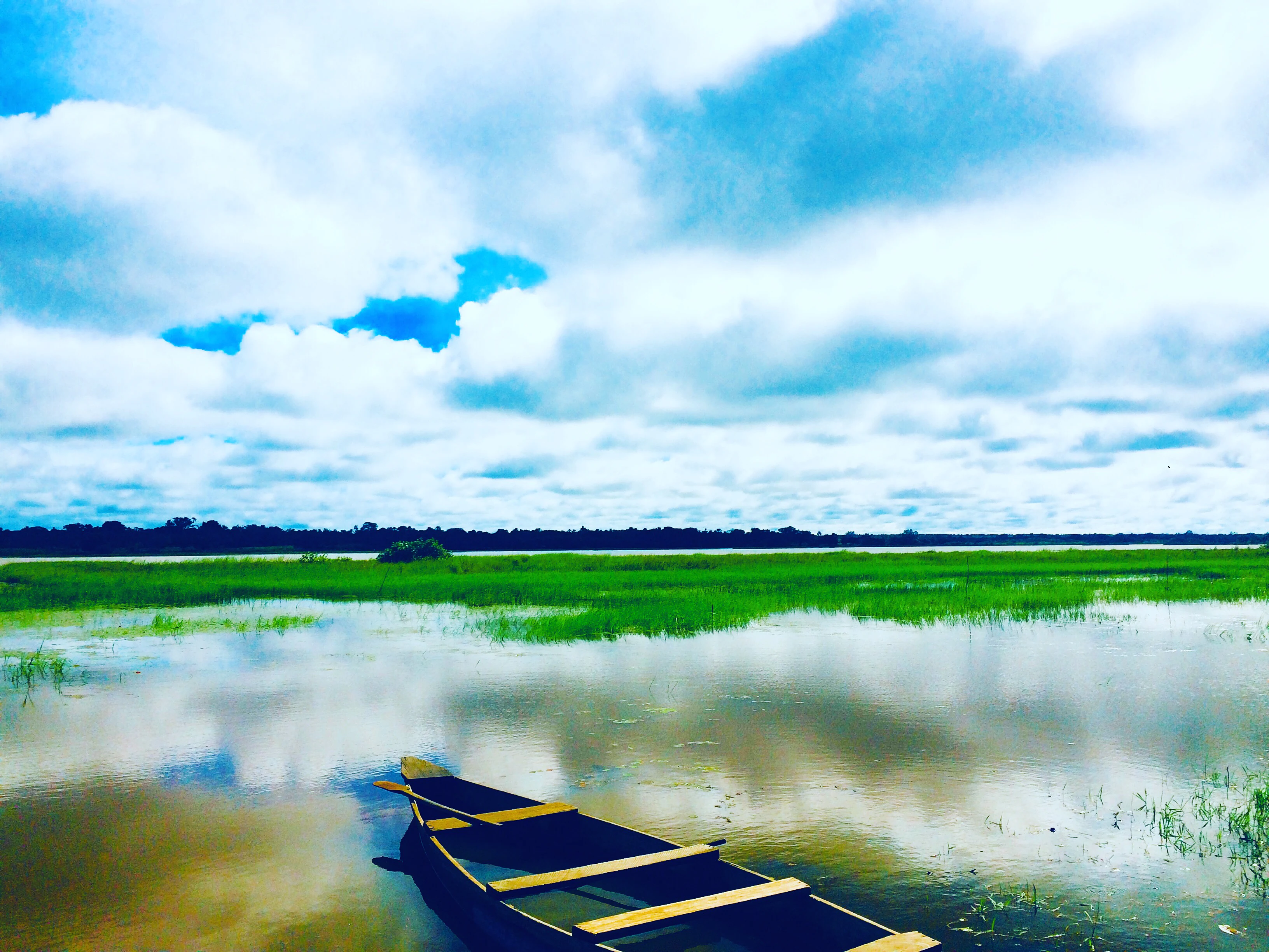
A wooden fishing boat sits in calm water near grassy wetlands under a cloudy blue sky.
A small wooden boat anchored on the waters of Lac de la Kompienga.

Lac de la Kompienga history and protected-area timeline

The history of Lac de la Kompienga begins with the Kompienga Dam project, which represented Burkina Faso's first major move into large-scale hydroelectric infrastructure on its own territory. The dam was constructed across the Kompienga River in the Est Region, and the reservoir began filling when the structure was closed in 1988, just under a decade before many of the country's later water projects came online.

The associated 14 MW power station was commissioned in 1989, and within a few years the site was already being studied for its wider development potential. Sectoral reviews at the time highlighted the project's multipurpose character, combining electricity generation with downstream irrigation along the Kompienga and the Oti, freshwater fisheries in the new reservoir, and pastoral uses including livestock watering and transhumance corridors through a livestock-dependent region.

By the early 2000s, the lake had become a focal point for riparian settlements and a more cosmopolitan fishery economy, drawing participants from several regions of Burkina Faso and neighboring countries. This human transformation was recognized in technical literature as both an opportunity for local development and a challenge for resource management. The site's growing ecological profile led to its inscription on the Ramsar List of Wetlands of International Importance on 7 October 2009, formalizing the reservoir's status as a wetland of international concern and providing a framework for its long-term conservation alongside its continuing role in energy, irrigation, and livelihoods.

Lac de la Kompienga landscape and geographic character

The physical landscape of Lac de la Kompienga is shaped by the contrast between a large artificial body of water and the surrounding dry savanna of southeastern Burkina Faso. The reservoir lies in the Est Region, mainly within Kompienga Province, along a road corridor that connects Fada N'Gourma with Pama and continues toward the borders with Togo and Benin. In elevation, the lake sits at around 176 meters above sea level, occupying a relatively low position within a region dominated by gently rolling Sudano-Sahelian terrain.

The shoreline is irregular and strongly influenced by the pre-existing valley system of the Kompienga River, a tributary linked to the Oti sub-basin of the Volta. As water levels fluctuate, the lake exposes broad muddy flats and shallow marginal zones, while other stretches of the shoreline form steeper banks where the reservoir meets the wooded slopes and rocky outcrops typical of the regional geology.

Surrounding the reservoir, the terrestrial landscape is characterized by dry woodland and savanna, with seasonal watercourses feeding the main basin. The combination of open water, fringing wetlands, rocky inselbergs, and dry forest gives the area a varied character for visitors and an important ecological gradient for wildlife accentuating the reservoir's importance as a habitat mosaic rather than a simple engineered lake.

Lac de la Kompienga ecosystems, habitats, and plant life

Ecologically, Lac de la Kompienga functions as a significant wetland node within a predominantly dry regional landscape. The reservoir creates a standing body of water in an area where natural permanent lakes are scarce, generating a mosaic of open water, seasonally flooded margins, and fringing marshland embedded within a matrix of Sudano-Sahelian savanna.

This habitat diversity supports a range of ecological functions. The open water and shallows provide habitat for fish populations that form the basis of the local fishery, while the flooded margins and surrounding wet soils are important for waterbirds, including migratory species that rely on a network of Sahelian wetlands. The mosaic of dry woodland, rocky outcrops, and wetter shoreline vegetation gives the area a layered ecological profile that extends well beyond the lake itself.

The site's ecological value was formally recognized through its designation as a Ramsar Wetland of International Importance in 2009, placing it within a global framework for wetland conservation. This international status reflects the lake's contribution to regional hydrology in the Volta Basin, its role as a refuge for waterbirds, and the importance of the surrounding habitats for maintaining ecological connectivity in eastern Burkina Faso.

Lac de la Kompienga wildlife and species highlights

The wildlife profile of Lac de la Kompienga is closely tied to its wetland character. While the surrounding savanna supports the typical fauna of the Est Region, the lake and its margins are particularly important for birdlife. The combination of open water, shallow margins, and seasonally flooded areas attracts resident and migratory waterbirds, including species that depend on the chain of Sahelian wetlands for survival.

Fish are another central component of the reserve's wildlife value. The reservoir hosts a developing freshwater fish community that supports one of the major human uses of the lake, with documented studies from the early 2000s anticipating several hundred to over a thousand tonnes of annual freshwater catch. This aquatic resource is not only economically important but also ecologically significant, as it structures predator-prey relationships in the open water and influences the food supply for waterbirds.

In the terrestrial surroundings, the dry savanna vegetation supports small and medium-sized mammals typical of the region, along with reptiles and a varied insect community that benefits from the wetter microclimates along the shoreline. Overall, the wildlife of Lac de la Kompienga reflects the broader pattern of dam-associated lakes in West Africa, where artificial reservoirs become focal points for biodiversity in otherwise water-limited landscapes.

Lac de la Kompienga conservation status and protection priorities

Conservation at Lac de la Kompienga is anchored in its Ramsar designation, granted on 7 October 2009 under the Convention on Wetlands of International Importance. This status formally recognizes the reservoir's ecological value at an international level and places it within a wider network of Sahelian and West African wetlands that share conservation commitments.

The conservation importance of the site goes beyond the open water itself. The Ramsar designation covers the lake and its associated marshy fringes, recognizing their role in supporting waterbird populations, fish habitats, and broader hydrological functions within the Volta Basin. In a regional context where many wetlands are under pressure from climate variability, land use change, and growing water demand, the site represents a notable example of a lake whose ecological value has been deliberately protected alongside its energy and resource uses.

At the national level, the reservoir is part of Burkina Faso's broader water and energy infrastructure, and its conservation is closely linked to the management of the Kompienga Dam and the surrounding riparian zone. Continued recognition of its Ramsar status reinforces the need to balance hydroelectric production, fisheries, livestock use, and emerging tourism with the long-term ecological integrity of the wetland complex.

Lac de la Kompienga cultural meaning and human context

The cultural context of Lac de la Kompienga is shaped by its location in the Est Region, an area historically characterized by transhumant pastoralism, cross-border trade, and the movement of peoples between Burkina Faso, Togo, and Benin. The creation of the reservoir transformed an already dynamic cultural landscape by creating new livelihood opportunities around fishing, settlement, and trade.

The lake has drawn fishers, traders, and service providers from multiple regions of Burkina Faso and neighboring countries, contributing to a more diverse and cosmopolitan riparian population. This was already noted in early-2000s studies, which described new forms of social organization around the reservoir, including structured fishing units and supply chains linking the lake to urban centers such as Ouagadougou.

The presence of a major hydroelectric dam in a previously less-connected area has also influenced the region's sense of modernity and development. For local communities, Lac de la Kompienga is both a working landscape, where livestock routes, fishing grounds, and downstream irrigation fields intersect, and a symbol of the country's investment in national infrastructure in the late twentieth century.

Top sights and standout views in Lac de la Kompienga

Lac de la Kompienga combines a distinctive set of features within a single site. It is Burkina Faso's first large hydroelectric reservoir, it holds Ramsar Wetland of International Importance status since 2009, and it sits within the broader Volta Basin system through its connection to the Oti sub-basin via the Kompienga River. The lake has also reshaped the human geography of the eastern part of the country, attracting new settlements, fisheries, and economic activities around what was once a relatively isolated stretch of savanna.

For visitors and researchers, the lake offers a layered experience: an engineered landscape with industrial heritage, a wetland habitat of recognized international value, and a meeting point of dry savanna and open water that produces striking scenery in a region where large permanent lakes are uncommon.

Best time to visit Lac de la Kompienga

Lake and wetland sites in the Sudano-Sahelian climate of eastern Burkina Faso are typically most rewarding to visit during the cooler dry season, when temperatures are milder, landscapes are less obscured by dust haze, and water levels tend to remain relatively stable after the rainy season has filled the reservoir and its surrounding wetlands. Birdwatching is often productive as migratory waterbirds make use of the open water and the fringing marshes, while local fishing activity continues year-round but tends to peak during cooler periods.

Visiting during the rainy season can be logistically more demanding due to road conditions and the seasonal flooding of low-lying areas around the reservoir, though it also represents the period when water levels and habitat diversity are at their highest. As with many sites in the region, individual visitors should plan around broader conditions of access rather than narrowly defined peak seasons.

Monthly climate preview

Long term monthly temperature averages and precipitation patterns for Kompienga Province

Lac de la Kompienga Climate Normals, Annual Temperature and Precipitation Rhythm

Representative coordinate records show measured temperature swings and shifting monthly precipitation totals across the year at Lac de la Kompienga. Examining the complete twelve month climate profile reveals full historical averages for regional temperature and rainfall.
Annual mean27 °C
24 °C31 °C
Jan25°
Feb28°
Mar31°
Apr31°
May30°
Jun28°
Jul26°
Aug26°
Sep26°
Oct27°
Nov26°
Dec24°
Warmest month
April

31.2 °C

Coolest month
December

24.4 °C

Wettest month
August

8.7 mm/day

Driest month
December

0 mm/day

Park location guide

Geography guide, regional context, and park location map for Lac de la Kompienga

Lac de la Kompienga park geography, regions, and map view in Burkina Faso

Understand where Lac de la Kompienga sits in Burkina Faso through a broader geographic reading of the surrounding landscape, nearby location context, and its mapped position within the national park landscape.

How Lac de la Kompienga fits into Burkina Faso

Burkina Faso is a landlocked West African nation. The Mossi people settled the area in the 11th and 13th centuries, establishing kingdoms such as Ouagadougou, Tenkodogo, and Yatenga. The French colonized the region in 1896 as part of French West Africa, and the country gained independence in 1960 as the Republic of Upper Volta before being renamed Burkina Faso in 1984 by President Thomas Sankara.

Wider geography shaping Lac de la Kompienga in Burkina Faso

Burkina Faso is a landlocked country in West Africa, bordered by Mali to the northwest, Niger to the northeast, Benin to the southeast, Togo and Ghana to the south, and Ivory Coast to the southwest. The terrain consists primarily of a peneplain with some laterite plateaus in the southeast. The country has several major rivers including the Mouhoun, Nakambe, and Comoé, though most are seasonal.

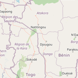
Map view of Lac de la Kompienga

Use this park location map to pinpoint Lac de la Kompienga in Burkina Faso, understand its exact geographic position, and read its mapped placement within the surrounding landscape more clearly.

Pigeon | © OpenStreetMap contributors

Location context for Lac de la Kompienga

Kompienga Province

Visualizing the reservoir scenery, shoreline wetlands, and surrounding dry savanna habitats.

Lac de la Kompienga Photos and Protected Area Landscapes

Visual documentation reveals the distinctive terrain and open water environments characteristic of this artificial reservoir in southeastern Burkina Faso. Examining these protected area views provides a clearer understanding of the shoreline wetlands and dry woodland mosaics shaping the region.

A wooden fishing boat sits in calm water near grassy wetlands under a cloudy blue sky.

A person stands in a shallow, narrow wooden boat pulled up onto the grassy, marshy shoreline of a large lake under a pale blue sky.

Park atlas

Compare adjacent wetland habitats and surrounding dry savanna landscapes

Parks Near Lac de la Kompienga and Regional Protected Areas

Browse protected areas and regional conservation zones situated near the shores of Lac de la Kompienga. Comparing these adjacent habitats reveals broader ecological patterns across the surrounding Sudano-Sahelian terrain.
National parkBenin
About 55 km away#1 closest

East

Pendjari National Park: Mapping Benin's Primary Protected Savanna Ecosystem and Wilderness

Located in northwestern Benin, bordering the WAP transboundary complex.

Pendjari National Park represents a significant conservation landscape in West Africa, featuring a complex geography of river-fed riparian forests, sprawling savanna plains, and the high-elevation cliffs of the Atakora mountain range. This protected area offers a look into an intact savanna wilderness, serving as a vital sanctuary for large mammals and diverse bird species within its clearly defined boundaries.

Area
2,755 km²
IUCN
II
Relief
Highland
Climate
Subtropical
A watercolor painting showing a wide, panoramic landscape featuring dry, open terrain, low rolling hills in the background, and sparse vegetation, including distinctive baobab trees.
National parkAtacora Department
About 55 km away#2 closest

East

Parc national de la Pendjari: Geographic Atlas and Protected Area Overview in Atacora Department

Savanna plains and quartzite mountain ridges in West Africa

Parc national de la Pendjari represents an ecologically vital protected landscape in the Atacora Department of Benin. This atlas overview details its complex geography, ranging from the flat sandstone peneplain to the permanent waters of the Pendjari River. Learn how these boundaries support one of the most significant contiguous savanna ecosystems in West Africa, featuring diverse habitats from gallery forests to open woodlands.

Area
4,700 km²
Established
1961
IUCN
II
Visitors
7K annual
National parkSavanes Region
About 67 km away#3 closest

Southwest

Fosse aux Lions National Park: National Park Exploration in Togo's Savanes Region

Mapped protected area geography and landscape context.

Fosse aux Lions National Park represents a distinct protected landscape within the Savanes Region of Togo. This entry focuses on its identity as a national park, providing structured information on its geographic placement and mapped boundaries. It serves as a core element for understanding the distribution of protected areas and the specific natural terrain within this region of Togo, aiding in comprehensive atlas-style exploration.

Area
16.5 km²
Established
1954
IUCN
II
Relief
Lowland
National parkTapoa Province
About 103 km away#4 closest

Northeast

Arli National Park National Park: Mapped Protected Landscape in Tapoa Province

Explore its geographic context and boundaries.

Arli National Park stands as a critical protected area, identified as a national park within Tapoa Province. This detail page serves as an atlas-focused entry point to understanding the park's unique landscape characteristics and its precise geographic location. Users can investigate its mapped boundaries and explore how it fits into the regional geography, offering a foundational understanding for protected-area discovery.

Area
760 km²
Established
1954
IUCN
IV
Relief
Upland
National parkKara Region
About 104 km away#5 closest

South

Oti-Kéran National Park: Togo's Vast Protected Savanna Ecosystem and Regional Geography

Explore the mapped terrain and protected landscape of this key national park.

Delve into the geography of Oti-Kéran National Park, Togo's largest national park situated in the Kara Region. This protected savanna landscape, recognized as a Ramsar site, offers insights into its unique sudanian zone terrain, important bird habitats, and its function as a wildlife migration corridor. Understanding its mapped boundaries and ecological significance provides a core piece of the West African protected areas atlas.

Area
690 km²
Established
1950
IUCN
II
Relief
Lowland
National parkNiger
About 137 km away#6 closest

Northeast

W National Park: Niger National Park, UNESCO World Heritage Site & Ramsar Wetland

Transborder savanna ecosystem and dramatic Niger River landscape.

W National Park in Niger offers a unique atlas view of a vast protected landscape defined by the Niger River's iconic W-shaped bend. As a UNESCO World Heritage Site and Ramsar Wetland, it protects crucial savanna plains, extensive floodplains, and rocky outcrops. This transborder conservation area is a vital habitat for West African wildlife, providing a rich context for geographic discovery and landscape exploration.

Area
10,000 km²
Established
1954
IUCN
II
Relief
Mixed relief
Watercolor illustration showing a calm river flowing through a soft landscape with distant rolling hills and light vegetation.
Wildlife reserveBurkina Faso
About 151 km away#7 closest

West

Lac de Bagré Wildlife Reserve: Mapping the Inland Reservoir of Central Burkina Faso

A critical wetland site within the Nakambé River valley.

Lac de Bagré acts as a major freshwater reservoir, stretching through the Boulgou and Zoundwéogo provinces of Burkina Faso. This artificial lake, created by the Bagré Dam, supports a unique ecological profile as a Ramsar-recognized wetland, offering a deep look into the intersection of hydrological infrastructure and protected Sahelian landscapes.

Area
367.93 km²
Established
1992
Water
Water-dominated
National parkBenin
About 183 km away#8 closest

East

Parc national du W du Benin: Regional Geography and Protected Savanna Landscapes

Northern Benin flagship protected area and transboundary conservation hub.

Located in northern Benin, Parc national du W du Benin provides a unique window into the Sudano-Sahelian zone. The park features a mosaic of riverine gallery forests along the Mékrou and Alibori rivers, stretching across open Sudanian savannas to meet the rugged edges of the Atacora mountains. This protected area stands as a central pillar in the WAP complex, offering a clear map of interconnected wildlife habitats and significant ecological corridors in West Africa.

Area
5,632.8 km²
Established
1950
IUCN
II
Relief
Upland

Common questions about visiting, size, designation, and location context for Lac de la Kompienga

Lac de la Kompienga FAQs for park facts, access, geography, and protected area context

Find quick answers about Lac de la Kompienga, including protected-area facts, park geography, trail and visitor context, and how the park fits into its surrounding country and regional landscape.
MoriAtlas Explorer

Continue Your Protected Areas Search Across the Global Atlas

Deepen your exploration by continuing the structured search for national parks and protected areas worldwide. Utilize the comprehensive filtering capabilities to compare different conservation landscapes and refine your understanding of global park geography. Discover more about the distribution and characteristics of protected natural areas.

Global natural geography