Mori Atlas logo
National parkArli National Park

Explore the mapped boundaries and regional geography of this significant protected area.

Arli National Park: National Park Protected Landscape and Geographic Context in Tapoa Province

Arli National Park represents a key protected natural landscape within Tapoa Province. This detailed entry provides insight into its designated status as a national park, offering users a focal point for understanding its geographic setting and mapped boundaries. Delve into the regional atlas context that Arli National Park occupies, understanding its place within the broader landscape of Burkina Faso through a structured, map-driven approach.

savanna ecosystemsgallery forestslarge mammal habitattransboundary protected areaUNESCO World Heritage SiteRamsar wetland

Arli National Park

National park

Park overview

Structured park overview, official facts, and landscape profile for Arli National Park

Arli National Park park facts, protected area profile, and essential visitor context
Review the core facts for Arli National Park, including designation, size, terrain, visitor scale, habitats, and operating context in one park-focused overview.

About Arli National Park

Arli National Park serves as a cornerstone of Burkina Faso's protected area network and plays a critical role in the broader W-Arly-Pendjari Complex that spans three countries in West Africa. The park's diverse topography ranges from the flat savanna plains to the elevated sandstone formations of the Gobnangou chain, creating a varied landscape that supports multiple ecological communities. The gallery forests that follow the Arli and Pendjari rivers provide critical habitat for species that require forest cover, while the surrounding savanna woodlands support the park's more visible large mammal populations. The park's location in southeastern Burkina Faso positions it as an important connectivity corridor between protected areas in Benin and the broader region. Management by NATURAMA, a local conservation organization, has provided continued attention to anti-poaching efforts and habitat management since 1993. The designation as a Ramsar site in 2009 acknowledged the international importance of the park's wetland habitats, particularly the river systems and seasonal pools that support hippos and other water-dependent species.

Quick facts and research context for Arli National Park

Arli National Park occupies 760 square kilometers in southeastern Burkina Faso, sharing its southern border with Benin's Pendjari National Park and bordering the Singou Reserve to the west. The park features a mosaic of habitats ranging from riverine gallery forests to savanna woodlands and sandstone ridgelines. It is home to approximately 200 African elephants, 200 hippos, and 100 lions, along with buffaloes, various antelope species, primates, and warthogs. The park can be accessed via the N19 highway through Diapaga, with additional dry-season access via Pama. Management has been delegated to the local NGO NATURAMA since 1993.

Park context

Deeper park guide and search-rich context for Arli National Park

Arli National Park history, landscape, wildlife, and travel context
Explore Arli National Park through its history, landscape character, ecosystems, wildlife, conservation priorities, cultural context, and seasonal travel timing in a structured park guide built for atlas discovery and search intent.

Why Arli National Park stands out

Arli National Park is best known for its significant populations of large mammals, particularly the approximately 200 African elephants that roam its savanna and forest habitats, and the approximately 100 lions that represent the West African lion subspecies. The park's gallery forests along the Arli and Pendjari rivers support hippo populations of around 200 individuals, with notable congregations at pools like Tounga where up to twenty hippos can be observed at waterholes. The park is also recognized for its role in the transboundary W-Arly-Pendjari Complex, a UNESCO World Heritage Site that represents one of West Africa's most important conservation landscapes.

Arli National Park history and protected-area timeline

Arli National Park was established in 1954 as a protected reserve, representing one of Burkina Faso's earliest conservation designations. The park's formal establishment reflected growing post-colonial interest in protecting West Africa's natural heritage and wildlife populations. Over the following decades, the park's status evolved, and it became integrated into the broader W-Arly-Pendjari Complex approach to transboundary conservation. The 1993 delegation of park management to NATURAMA marked a significant shift toward community-based conservation and local NGO involvement in protected area management in Burkina Faso. The park gained additional international recognition when the W-Arly-Pendjari Complex was inscribed as a UNESCO World Heritage Site in 1996, with an extension in 2017. The Ramsar designation in 2009 further cemented the park's international significance, recognizing its wetland habitats under the Convention on Wetlands of International Importance.

Arli National Park landscape and geographic character

The landscape of Arli National Park is characterized by a diverse mix of ecosystems that create a visually varied terrain across its 760 square kilometer extent. The gallery forests along the Arli and Pendjari rivers form dense corridors of vegetation that contrast sharply with the surrounding savanna, creating a distinctive pattern of forest-lined watercourses cutting through open woodland. The savanna woodland areas dominate much of the park, featuring scattered trees and shrubs across rolling grassland that provides optimal viewing conditions for wildlife. In the western portions of the park, the sandstone hills of the Gobnangou chain rise above the surrounding plains, offering more rugged terrain and varied rock formations. The park contains several permanent pools and seasonal waterholes, with Tounga being particularly notable as a reliable water source that attracts concentrations of hippos and other wildlife during the dry season.

Arli National Park ecosystems, habitats, and plant life

The ecological character of Arli National Park reflects its position in the Sudanian zone of West Africa, with a blend of forest and savanna habitats that supports remarkable biodiversity. The gallery forests along the major rivers represent the most biologically dense habitats, providing shelter, food, and movement corridors for forest-dependent species. These narrow strips of dense vegetation contrast with the broader savanna woodlands that occupy the majority of the park's area, where grass-dominated understories support grazers and the scattered trees provide browse for browsers. The park's wetland areas, including the rivers and permanent pools, form critical ecological anchors that sustain water-dependent species throughout the year, particularly during the long dry season. The Ramsar designation acknowledges these wetland systems as internationally significant, recognizing their role in supporting biodiversity and ecological processes.

Arli National Park wildlife and species highlights

Arli National Park supports significant populations of large mammals that represent the park's primary wildlife interest. The approximately 200 African elephants represent a substantial population that roams both the forest and savanna habitats, though the species faces ongoing pressure across its range in West Africa. The lion population of approximately 100 individuals represents an important stronghold for the West African lion subspecies, which is considered regionally vulnerable. Hippos numbering around 200 individuals concentrate around the park's permanent pools, with Tounga supporting particularly large congregations of up to twenty hippos at any given time. The park also supports populations of buffaloes, various antelope species including western hartebeest, roan antelope, bushbucks, duikers, and waterbuck. Primates are well represented with baboons, red monkeys, and green monkeys common throughout the park. Warthogs and other smaller mammals round out the mammalian fauna. Historically, the park supported populations of West African wild dog, though this canid has likely been locally extirpated due to human population expansion and inadequate protection.

Arli National Park conservation status and protection priorities

Arli National Park plays a critical role in regional conservation efforts as part of the W-Arly-Pendjari Complex, which represents one of West Africa's largest and most important protected area networks. The UNESCO World Heritage designation underscores the global significance of this transboundary landscape, which provides critical habitat for elephants, lions, and other flagship species. The Ramsar designation since 2009 acknowledges the international importance of the park's wetland habitats, particularly the river systems and pools that support hippos and provide dry-season water for wildlife. Management by NATURAMA since 1993 has provided continuity of conservation attention, though the park faces challenges from expanding human populations in the surrounding region. The park's position adjacent to Pendjari National Park in Benin and the Singou Reserve in Burkina Faso creates important connectivity for wildlife movements across the broader landscape.

Arli National Park cultural meaning and human context

Arli National Park is situated in Tapoa Province in southeastern Burkina Faso, a region characterized by rural communities whose traditional livelihoods involve agriculture and livestock husbandry. The park's establishment in 1954 introduced formal protection to a landscape that had long been used by local communities for various purposes. The delegation of management to NATURAMA in 1993 reflected a growing recognition of the importance of community engagement in conservation, though specific details about indigenous or traditional land use within the park are limited in available sources. The park's proximity to Benin creates a transboundary dimension that has implications for both conservation management and local communities across the international border.

Top sights and standout views in Arli National Park

The standout features of Arli National Park include its substantial elephant and lion populations, the dramatic congregations of hippos at pools like Tounga, and the scenic contrast between gallery forests and savanna landscapes. The park's inclusion in the W-Arly-Pendjari Complex and its UNESCO World Heritage status distinguish it as a globally significant conservation area. The Ramsar designation adds recognition for the park's wetland values. Visitors accessing the park via the N19 highway through Diapaga can experience a range of habitats within a relatively compact area, with the gallery forests providing particularly memorable wildlife viewing opportunities along the river courses.

Best time to visit Arli National Park

The optimal time to visit Arli National Park falls during the dry season, typically from November through April, when wildlife congregates more predictably around the remaining water sources and vegetation is less dense, improving visibility. The dry season conditions allow for access via the N19 highway through Diapaga, with the additional dry-season route via Pama also available. During this period, the hippos at Tounga and other pools are more easily observed as water becomes scarcer in the surrounding landscape. The wet season from May through October brings lusher vegetation and greener landscapes but can make wildlife viewing more challenging and may affect road accessibility within the park.

Park location guide

Geography guide, regional context, and park location map for Arli National Park

Arli National Park park geography, regions, and map view in Burkina Faso
Understand where Arli National Park sits in Burkina Faso through a broader geographic reading of the surrounding landscape, nearby location context, and its mapped position within the national park landscape.

How Arli National Park fits into Burkina Faso

Burkina Faso is a landlocked West African nation. The Mossi people settled the area in the 11th and 13th centuries, establishing kingdoms such as Ouagadougou, Tenkodogo, and Yatenga. The French colonized the region in 1896 as part of French West Africa, and the country gained independence in 1960 as the Republic of Upper Volta before being renamed Burkina Faso in 1984 by President Thomas Sankara.

Wider geography shaping Arli National Park in Burkina Faso

Burkina Faso is a landlocked country in West Africa, bordered by Mali to the northwest, Niger to the northeast, Benin to the southeast, Togo and Ghana to the south, and Ivory Coast to the southwest. The terrain consists primarily of a peneplain with some laterite plateaus in the southeast. The country has several major rivers including the Mouhoun, Nakambe, and Comoé, though most are seasonal.

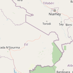
Map view of Arli National Park

Use this park location map to pinpoint Arli National Park in Burkina Faso, understand its exact geographic position, and read its mapped placement within the surrounding landscape more clearly.

Pigeon | © OpenStreetMap contributors

Location context for Arli National Park

Tapoa Province
Park atlas

Trace the Connected Protected Landscapes of the W-Arly-Pendjari Complex and West Africa

Explore Nearby National Parks and Protected Areas around Arli National Park
After exploring Arli National Park, delve into the broader network of protected areas and national parks that shape West African conservation, comparing diverse savanna ecosystems and gallery forest habitats. This regional view allows for structured discovery of adjacent conservation landscapes, providing essential geographic context beyond a single park's boundaries.
National parkBenin

Pendjari National Park: Exploring Benin's Largest Protected Area and Savanna Landscape

Mapped boundaries and regional geography of a key West African wilderness.

Pendjari National Park is the largest protected area in Benin, safeguarding nearly 2,800 square kilometers of essential West African savanna ecosystem. This national park is a crucial element of the WAP Complex, offering a profound look at one of the region's last viable wilderness expanses. Through its mapped terrain, diverse landscapes from river valleys to mountainous cliffs, and its status as a protected landscape, users gain a deep understanding of its geographic significance and conservation value.

Area
2,755 km²
IUCN
II
Relief
Highland
Climate
Subtropical
National parkNiger

W National Park: Niger National Park, UNESCO World Heritage Site & Ramsar Wetland

Transborder savanna ecosystem and dramatic Niger River landscape.

W National Park in Niger offers a unique atlas view of a vast protected landscape defined by the Niger River's iconic W-shaped bend. As a UNESCO World Heritage Site and Ramsar Wetland, it protects crucial savanna plains, extensive floodplains, and rocky outcrops. This transborder conservation area is a vital habitat for West African wildlife, providing a rich context for geographic discovery and landscape exploration.

Area
10,000 km²
Established
1954
IUCN
II
Relief
Mixed relief
National parkKara Region

Oti-Kéran National Park: Togo's Vast Protected Savanna Ecosystem and Regional Geography

Explore the mapped terrain and protected landscape of this key national park.

Delve into the geography of Oti-Kéran National Park, Togo's largest national park situated in the Kara Region. This protected savanna landscape, recognized as a Ramsar site, offers insights into its unique sudanian zone terrain, important bird habitats, and its function as a wildlife migration corridor. Understanding its mapped boundaries and ecological significance provides a core piece of the West African protected areas atlas.

Area
690 km²
Established
1950
IUCN
II
Relief
Lowland
Watercolor depiction of a river flowing through a landscape with green trees and distant mountains under a light sky
National parkBurkina Faso

Kaboré Tambi National Park: Burkina Faso's Largest National Park and Protected Landscape

Explore the mapped savanna and birdwatching geography of this vital West African area.

Kaboré Tambi National Park represents a critical protected area in Burkina Faso, spanning a considerable expanse of Sudan-Guinea savanna. The park's geography is defined by the Nazinon River and a mosaic of woodland and grassland ecosystems, making it a significant site for understanding regional protected lands and landscape ecology. It offers a valuable point of reference for atlas-based exploration of West African natural areas.

Area
1,555 km²
Established
1976
IUCN
II
Relief
Lowland
National parkNigeria

Kainji National Park: Nigeria's National Park for Geographic Discovery

Mapped protected landscape and regional geographic context.

Kainji National Park represents a significant protected landscape within Nigeria, offering a distinct focal point for geographic atlas exploration. As a national park, its mapped boundaries and regional context are essential for understanding the distribution of natural areas in West Africa. This entry provides a grounded perspective on its landscape, enabling detailed study for those interested in the structured geography of conservation lands.

Area
5,340.82 km²
Established
1978
IUCN
II
Relief
Lowland
National parkOti Region

Kyabobo National Park: Ghana's Highland National Park with Mount Dzebobo and Forest-Savanna Transition

Explore mountainous terrain, park boundaries, and regional geography in Oti Region.

Kyabobo National Park is a significant protected landscape in Ghana's Oti Region, celebrated for its mountainous topography and the commanding presence of Mount Dzebobo. This national park, established in 1993, safeguards a critical ecological transition zone featuring diverse habitats from dense forests to open tree savanna. Its unique geography and protected status make it a vital site for understanding regional conservation and atlas-based landscape exploration in West Africa, offering insights into varied terrain and ecosystems.

Area
360 km²
Established
1993
IUCN
II
Relief
Mountain
National parkSavannah Region

Mole National Park: A Premier Protected Landscape in Ghana's Savannah Region

Explore mapped boundaries and Guinea savannah ecosystems.

Mole National Park represents a significant protected landscape within Ghana's Savannah Region, serving as the country's largest national park and a crucial conservation area for West African wildlife. The park's geography is defined by extensive Guinea savannah, characterized by grasslands with scattered woodlands and a prominent escarpment along its southern edge. Its vast expanse offers a unique opportunity to study mapped park boundaries and understand the ecosystem's role in regional conservation efforts. Discover the unique landscape context and protected area identity of this major West African wildlife refuge.

Area
4,840 km²
Established
1958
IUCN
II
Visitors
17.8K annual
National parkOyo State

Old Oyo National Park: Mapped Savanna Terrain and Historical Significance in Nigeria

Explore its geographic setting and protected landscape features.

Old Oyo National Park is a prominent national park situated in Nigeria's Oyo State, covering a substantial area of lowland savanna. The park's terrain features include scattered granite outcrops, ridges, and important archaeological sites, remnants of the ancient Oyo Empire. Its mapped geography reveals a dynamic landscape shaped by river systems and elevated formations, offering a unique blend of natural and cultural heritage for dedicated atlas exploration.

Area
2,512 km²
IUCN
II
Relief
Lowland
Climate
Tropical

Common questions about visiting, size, designation, and location context for Arli National Park

Arli National Park FAQs for park facts, access, geography, and protected area context
Find quick answers about Arli National Park, including protected-area facts, park geography, trail and visitor context, and how the park fits into its surrounding country and regional landscape.
MoriAtlas Explorer

Continue Your Protected Areas Search Across the Global Atlas

Deepen your exploration by continuing the structured search for national parks and protected areas worldwide. Utilize the comprehensive filtering capabilities to compare different conservation landscapes and refine your understanding of global park geography. Discover more about the distribution and characteristics of protected natural areas.

Global natural geography