
Mori Atlas logo
Nature reserveLago di Piano

Mapping the protected glacial basin, drumlins, and reed-fringed margins of Val Menaggio

Lago di Piano Nature Reserve: A Glacial Wetland Landscape in the Lombardy Foothills

Lago di Piano is a distinct glacial nature reserve nestled within the Val Menaggio of northern Lombardy. Defined by its shallow basin and surrounding pre-Alpine slopes, this protected area features a mosaic of open water, floating carpets of lilies, and marshland habitats. The geography reveals a unique blend of ancient drumlins and human history, offering a concentrated look at how glacial terrain shapes the ecology and natural character of the Italian foothills.

glacial lakewetlandnature reservebirdwatchingpre-alpine foothillsdrumlins
A flat-style digital illustration of a lake surrounded by mountains, a waterfall, and a small wooden dock with picnic tables.

Lago di Piano

Nature reserve

Park overview

Structured park overview, official facts, and landscape profile for Lago di Piano

Lago di Piano park facts, protected area profile, and essential visitor context

Review the core facts for Lago di Piano, including designation, size, terrain, visitor scale, habitats, and operating context in one park-focused overview.

About Lago di Piano

Lago di Piano is a small but ecologically significant lake in the Menaggio valley of Lombardy, northern Italy. Tucked into the foothills just a few kilometers east of the western arm of Lake Lugano, it occupies a quiet lowland basin behind the lakeside town of Porlezza and the village of Carlazzo. Although it covers less than a square kilometer of surface water, the lake and its immediate surroundings have come to represent one of the most important freshwater wetland oases in the Lombard pre-Alps.

The landscape around Lago di Piano reflects a complex glacial history. The Menaggio valley itself was carved into a broad U-shape by a branch of the great Adda glacier that once flowed southward from Valtellina and Valchiavenna. As the ice retreated, meltwater streams from the neighboring Val Cavargna and Val Rezzo deposited enormous volumes of clay, sand, and fine debris in the lowlands, gradually separating the eastern end of Lake Lugano from the main Ceresio basin. The cutoff basin that remained became Lago di Piano, while the surrounding flatlands evolved into marsh and meadow.

Today the lake lies at the heart of the Riserva naturale Lago di Piano, a regional nature reserve that has been formally recognized by the European Union as a Site of Community Importance. Dense beds of white and yellow water lilies float across much of the surface, while the margins shift between open reed beds, sedge meadows, and willow thickets. This mosaic of aquatic and semi-aquatic habitats supports an unusually rich community of birds, fish, mammals, and invertebrates, fulfilling conservation roles that extend well beyond the modest size of the water body itself.

Beyond its ecological role, Lago di Piano remains woven into the everyday life of the local communities. Its shores host campsites and small beaches in summer, while in winter the persistent shadow of Monte Galbiga allows the surface to freeze early and reliably, giving the lake a second seasonal personality as a community ice-skating venue. Surrounding glacial drumlins carry the remains of old lookout towers and the medieval hamlet of Castel San Pietro, reminding visitors that this wetland oasis has been a recognizable feature of the landscape for many centuries.

Quick facts and research context for Lago di Piano

Lago di Piano is a small pre-Alpine lake in Lombardy, sitting in the comune area of Carlazzo and just behind the town of Porlezza in the province of Como. It lies at roughly 276 meters above sea level in Val Menaggio, near the western arm of Lake Lugano (Ceresio). The lake has a surface area of about 0.72 square kilometers, a maximum depth of around 13 meters, and a catchment basin of roughly 26 square kilometers. Its principal tributary is the Torrente Civagno, which descends from Monte di Tremezzo, and its single outflow is the artificial Lagadone canal, cut around 1700 to drain the surrounding marshes.

The lake is enclosed within the Riserva naturale Lago di Piano, a large protected oasis recognized as a Site of Community Importance by the European Union. The reserve supports dense beds of white water lilies and yellow water lilies, fringing reeds, and sedge communities, alongside mammal, reptile, fish, and especially rich birdlife. Surrounded by glacial drumlins and overlooked by forested slopes, it represents one of the southern Alpine foothills' most notable low-elevation wetland complexes.

Protection and recognition

Documented terrestrial protection scope and official designation records

Lago di Piano Protection Status and Natura 2000 Recognition Data

Terrestrial protection records for Lago di Piano compile documented management scope and official Natura 2000 recognition data. Verified administrative sources outline the established conservation framework governing this protected landscape.

International recognition

Protection details

Protection scope
Terrestrial
Transboundary protection
No
Park context

Deeper park guide and search-rich context for Lago di Piano

Lago di Piano history, landscape, wildlife, and travel context

Explore Lago di Piano through its history, landscape character, ecosystems, wildlife, conservation priorities, cultural context, and seasonal travel timing in a structured park guide built for atlas discovery and search intent.

Why Lago di Piano stands out

Lago di Piano is best known as a protected wetland oasis in the foothills of the Lombard pre-Alps, where a glacial lake is encircled by marshes, floating water-lily beds, and reed belts. It is recognized across Europe as a Site of Community Importance and harbors an unusually high concentration of bird species for such a small water body. The lake is also notable for its clear glacial origins, set within the U-shaped Val Menaggio carved by a branch of the ancient Valtellina glacier, and for the traditional winter practice of gathering ice from its frozen surface, a custom that shaped the local use of the lake for centuries.
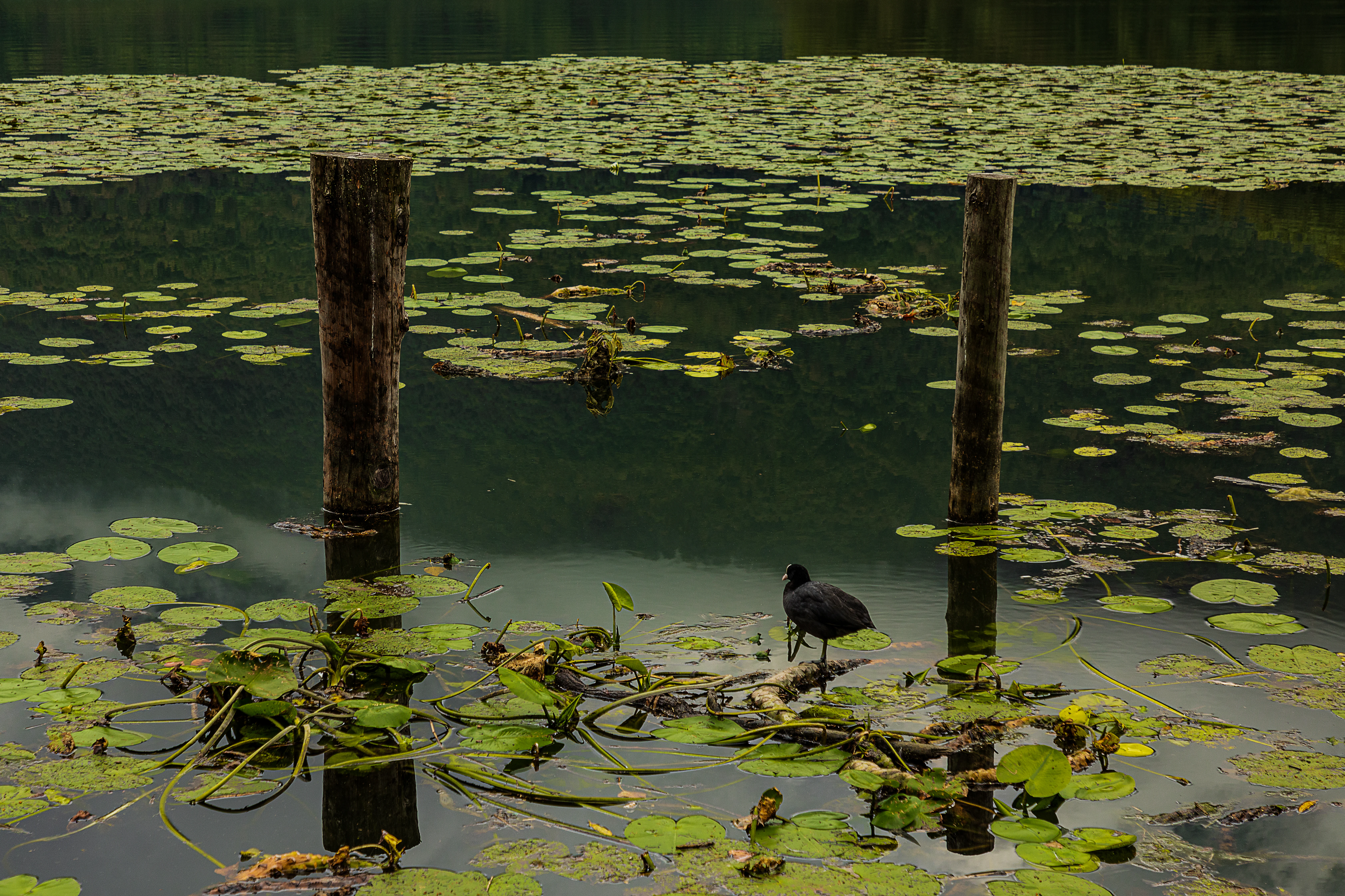
A small dark water bird standing on a piece of wood in a lake, surrounded by floating water lily pads and two wooden pilings.
A small water bird stands amongst water lilies on the surface of Lago di Piano.

Lago di Piano history and protected-area timeline

Lago di Piano's history begins with the Quaternary glaciations, when a branch of the ancient Adduano glacier flowed westward along the geological fault known as the Menaggio line, carving out what would become Val Menaggio. As the climate warmed and the ice retreated, meltwater and debris from neighboring valleys built up natural dams at the eastern edge of the Ceresio basin, eventually isolating a separate lake body that we now know as Lago di Piano.

In more recent centuries, the lake and its surrounding marshes have been actively managed by local communities. Around 1700, the Lagadone canal was cut through to drain some of the wetland between Lago di Piano and Lake Lugano, converting part of the marsh into usable land. The frozen surface of the lake was once a resource in its own right: blocks of ice were cut and stored in ice cellars at Tremezzo and Como, supplying refrigeration before modern technology arrived.

On one of the drumlins that emerges from the lake stand the remains of Castel San Pietro, a walled hamlet built over the foundations of an older Roman-era lookout tower. That tower was once part of a visual signaling chain with similar towers at Carlazzo and at Le Torri, higher up toward San Bartolomeo Val Cavargna, illustrating that this small lake has been a recognizable landmark and strategic point within the Menaggio corridor since antiquity. In the modern era, the recognition of the lake as a regional nature reserve and as a European Site of Community Importance marked a turning point, framing the historic wetland as a protected ecological treasure rather than merely a local amenity.

Lago di Piano landscape and geographic character

The physical landscape of Lago di Piano is shaped by glacial processes on a relatively small scale. The lake sits in a low valley basin at around 276 meters above sea level, framed by the wooded slopes of Monte di Tremezzo and Monte Galbiga. These surrounding mountains drop steeply toward the water, their shadows influencing both the local climate and the way the lake freezes in winter.

A defining feature of the area is the presence of drumlins, low, whale-shaped hills of glacial deposit, one of which projects into the lake and carries the ruins of Castel San Pietro. The broader valley floor is a patchwork of former marshland now partially drained, gentle meadows, and the flat surfaces of alluvial fans built up by the Cuccio and Rezzo streams. Together, these landforms create a scenic transition between steep pre-Alpine slopes and the broad valley that opens westward toward Lake Lugano.

The lake itself is shallow, reaching only about 13 meters at its deepest, and broadens across roughly 0.72 square kilometers. Its shallow basin, combined with calm inflows from the Civagno stream, encourages the growth of extensive floating vegetation and gives the water a quiet, reflective character typical of low-elevation glacial lakes.
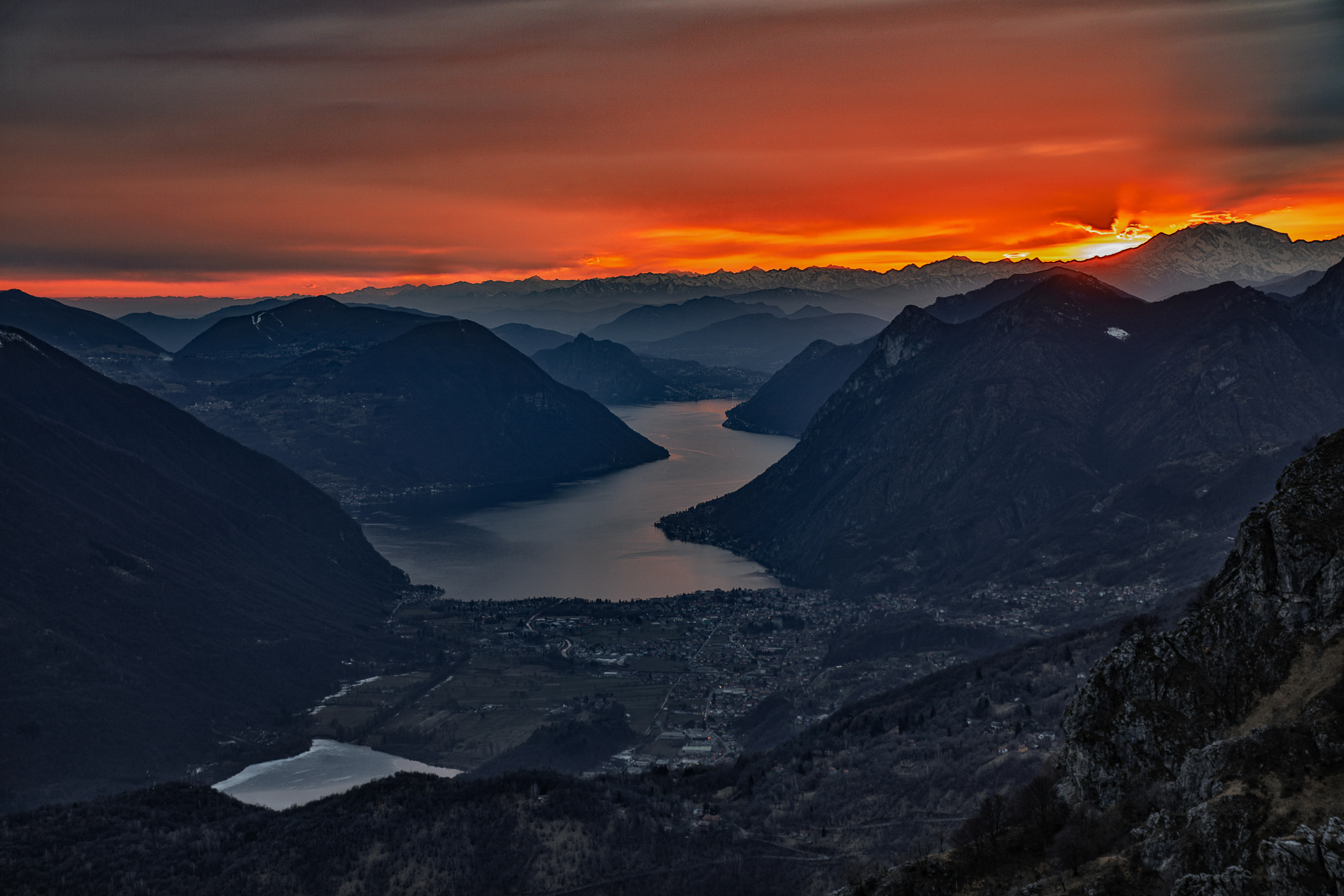
A wide, high-angle landscape shot of a narrow lake nestled between steep, dark mountain ridges during a vibrant sunset with orange and red clouds.
Sunset view over Lago di Piano and the surrounding valley in the Italian Alps.

Lago di Piano ecosystems, habitats, and plant life

The ecological identity of Lago di Piano rests on the combination of open water, floating vegetation, reedbeds, and adjacent wet meadows within a single compact area. Much of the lake's surface is covered by thick colonies of white water lily, yellow water lily, and water chestnut, creating dense green and white carpets that shift gently with the wind and serve as habitat for fish, invertebrates, and nesting waterbirds.

Along the margins, the typical zonation of lowland lake vegetation is clearly visible. Floating plants give way to a narrow belt of reeds and emergent species, including common reed and broad-leaved cattail, before transitioning into sedge communities where bogbean and grey willow take over. Beyond the immediate shoreline, damp meadows and marshy pastures extend the wetland habitat into the surrounding valley, providing feeding and breeding grounds for a wide array of species.

Because the valley floor is relatively low and sheltered, and because the surrounding slopes protect the basin from strong winds, Lago di Piano maintains stable water levels and gentle thermal conditions that favor aquatic plant growth. This stability, combined with the diversity of microhabitats in a small area, is what makes the lake ecologically richer than its size alone would suggest.
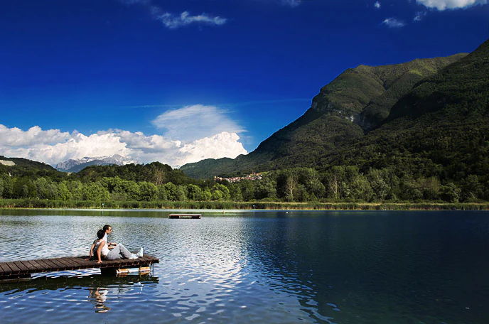
A person sits on a wooden dock extending into a calm blue lake, with dense green trees and large mountain peaks under a clear blue sky with white clouds.
A person sitting on a wooden pier overlooking the calm waters of Lago di Piano, backed by mountain slopes.

Lago di Piano wildlife and species highlights

The Lago di Piano area supports a remarkably diverse community of animals for such a small lake. Documented fauna include around 26 species of mammals, including small mammals and bats, 17 species of fish, 6 reptile species, and no fewer than 141 recorded bird species. Among the mammals frequently associated with the area are roe deer, hares, weasels, and marmots, alongside a wider community of small mammals adapted to wetland margins and surrounding woodland.

The birdlife is the standout feature of the reserve. Ducks such as mallards gather along the reed edges, while coots move easily through the floating lily beds. The mix of open water, marsh, meadow, and nearby woodland provides habitat for waders, herons, and a wide range of smaller wetland and woodland passerines, accounting for the extraordinary species count.

In the waters themselves, the lake hosts a notable population of the native crayfish Austropotamobius italicus, an endemic species of conservation concern whose presence in Lago di Piano is considered particularly significant within the broader Italian context.
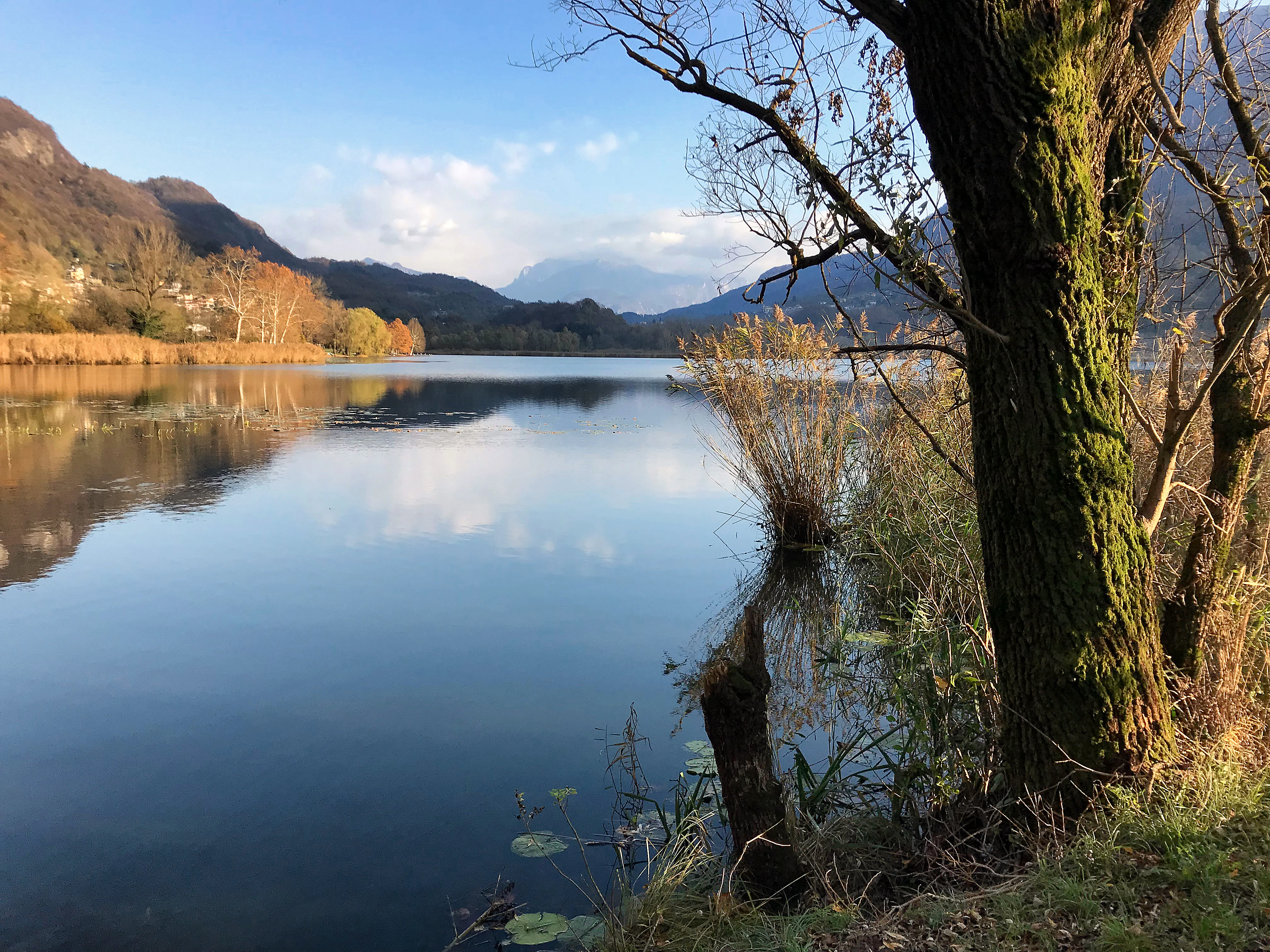
A calm lake reflecting the surrounding hills and sky with a large tree in the foreground on the right.
A peaceful view across the reflective waters of Lago di Piano, surrounded by hills in the Lombardy region.

Lago di Piano conservation status and protection priorities

Lago di Piano is one of the freshwater sites in Lombardy with formal European conservation status. The lake and its surrounding wetlands lie within the Riserva naturale Lago di Piano, a nature reserve managed at the regional level, and have been officially designated as a Site of Community Importance by the European Union under the Natura 2000 framework.

Its conservation value lies in the concentration of multiple sensitive habitat types within a small area: floating water lily beds, reedbeds, sedge marshes, wet meadows, and surrounding deciduous woodland. These habitats shelter rare and declining species, including the Italian crayfish Austropotamobius italicus, and host one of the richest bird communities of any comparable lowland site in the pre-Alpine region. Recognition as a Site of Community Importance means that the lake is considered important for maintaining biodiversity at a European scale, not only at a regional level.

Lago di Piano cultural meaning and human context

The cultural context of Lago di Piano is deeply rooted in the long relationship between local communities and the wetland landscape. For centuries, inhabitants of the Menaggio valley have used the lake not only as a scenic landmark but as a practical resource: ice cut from its frozen surface was stored and distributed to communities including Tremezzo and Como, an activity that shaped local food preservation practices in the pre-refrigeration era.

The hill rising from the water once carried a Roman-era signaling tower that linked visually with other towers in the chain toward Val Cavargna. The medieval hamlet of Castel San Pietro, built around these earlier foundations, illustrates how strategic and settlement history overlapped with the natural geography of the lake. Today the area combines traditional rural land use, seasonal tourism, and conservation management, a balance that reflects how the local population continues to adapt to, and benefit from, the wetland environment.
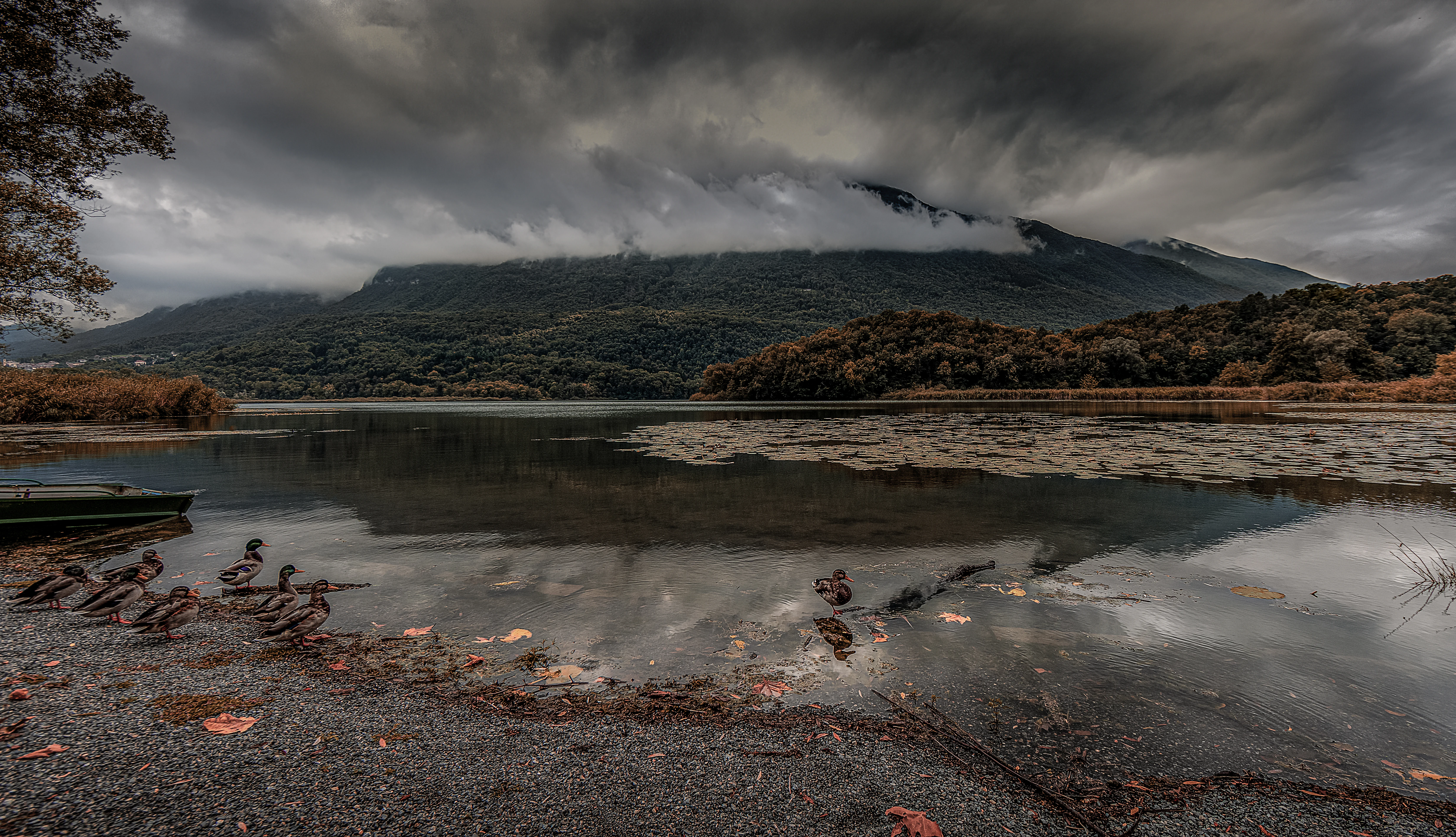
A wide landscape view of a lake with dark, overcast clouds clinging to the mountains in the background, a small boat on the left shore, and lily pads floating on the water surface.
A moody view across the waters of Lago di Piano Nature Reserve under a heavy, clouded sky.

Top sights and standout views in Lago di Piano

Lago di Piano combines dramatic glacial origins with one of the richest wetland ecosystems in the Lombard pre-Alps, making it a focal point for nature conservation in the Menaggio valley. The lake's signature feature is the contrast between deep blue open water and the bright carpets of white and yellow water lilies that drift across much of its surface, framed by reedbeds and forested slopes.

Equally distinctive is the drumlin rising out of the water, crowned by the remains of Castel San Pietro, which gives the landscape its unusual fusion of natural and human history. Whether visited in summer for its birdwatching opportunities and waterside camping or in winter for the unusual experience of skating on a frozen lowland lake, Lago di Piano offers a compact but powerful example of how glacial geology, biodiversity, and centuries of human presence have come together in one small valley.

Best time to visit Lago di Piano

Lago di Piano has two distinct seasonal personalities that make different parts of the year appealing. Late spring and summer are the most rewarding periods for wildlife observation, when floating water lilies are in full bloom, the reedbeds host active breeding birds, and the surrounding meadows draw insects and other fauna. Warm, still days offer the best photographic conditions for the lake's signature lily-covered surface and views toward Porlezza and Lake Lugano beyond.

Winter brings a very different atmosphere. Because the surrounding mountains, particularly Monte Galbiga, cast a persistent shadow over the basin, the lake tends to freeze from December into early February in many years. This frozen surface transforms the site into a local ice-skating venue and gives visitors a rare chance to experience a lowland lake in a distinctly alpine seasonal mood. Shoulder seasons of late autumn and early spring tend to be quieter, with soft light over the marshes and fewer visitors around the campsites.

Monthly climate preview

Long-term representative measurements illustrating monthly thermal variations and precipitation patterns

Lago di Piano Climate Normals, Annual Temperature and Precipitation Rhythm

Historical climate data for Lago di Piano details a measured annual progression of average temperatures alongside steady monthly precipitation records. Examining the complete twelve-month profile provides deeper insight into long-term thermal rhythms and moisture distribution.
Annual mean8 °C
-2 °C19 °C
Jan-2°
Feb
Mar
Apr
May12°
Jun17°
Jul19°
Aug18°
Sep14°
Oct
Nov
Dec-1°
Warmest month
July

18.7 °C

Coolest month
January

-1.9 °C

Wettest month
November

4.7 mm/day

Driest month
February

1.8 mm/day

Park location guide

Geography guide, regional context, and park location map for Lago di Piano

Lago di Piano park geography, regions, and map view in Italy

Understand where Lago di Piano sits in Italy through a broader geographic reading of the surrounding landscape, nearby location context, and its mapped position within the national park landscape.

How Lago di Piano fits into Italy

Italy is a unitary parliamentary republic in Southern and Western Europe, located on the Italian Peninsula with the Alps to the north. It borders France, Switzerland, Austria, Slovenia, Vatican City, and San Marino, and shares maritime boundaries with several Mediterranean countries. The country has approximately 59 million residents and uses the Euro as its currency.

Wider geography shaping Lago di Piano in Italy

Italy occupies a boot-shaped peninsula in southern Europe, bordered by the Alps to the north. It shares land borders with France, Switzerland, Austria, Slovenia, Vatican City, and San Marino. The country includes the Mediterranean islands of Sicily and Sardinia, along with approximately 800 smaller islands.

Map view of Lago di Piano

Use this park location map to pinpoint Lago di Piano in Italy, understand its exact geographic position, and read its mapped placement within the surrounding landscape more clearly.

Pigeon | © OpenStreetMap contributors

Location context for Lago di Piano

LombardiaProvincia di Como
Recorded earthquake history

Review the Seismic History and Earthquake Records for Lago di Piano

Explore the collection of seismic events documented near Lago di Piano through the MoriAtlas catalogue. These records provide historical context for the region, detailing event magnitudes and proximity to the nature reserve to assist in geographic analysis of the Val Menaggio landscape.

Lago di Piano Earthquake History

Catalogued events

10 events

Strongest magnitude

Magnitude 4.5

Most recent event

Apr 29, 2002

This history includes earthquakes recorded inside the park or within 50 km of its borders

Explore protected wetland habitats, glacial valley terrain, and pre-Alpine scenery.

Lago di Piano Photos and Landscape Scenery Visual Guide

Examine high-resolution imagery revealing the glacial valley terrain, floating water-lily beds, and reed-fringed shores defining this protected wetland. Visual research helps observers understand the rare lowland ecosystems and pre-Alpine topography characterizing the reserve.

A small dark water bird standing on a piece of wood in a lake, surrounded by floating water lily pads and two wooden pilings.

A wide angle view of a wooden observation deck extending into a lake, featuring several picnic tables and a view of mountains under a cloudy sky.

A wide, high-angle landscape shot of a narrow lake nestled between steep, dark mountain ridges during a vibrant sunset with orange and red clouds.

A person sits on a wooden dock extending into a calm blue lake, with dense green trees and large mountain peaks under a clear blue sky with white clouds.

A calm lake reflecting the surrounding hills and sky with a large tree in the foreground on the right.

A black and white landscape showing several upturned rowboats on a pebbly lakeshore, with a calm lake and rolling, tree-covered hills in the background.

A wide landscape view of a lake with dark, overcast clouds clinging to the mountains in the background, a small boat on the left shore, and lily pads floating on the water surface.

Park atlas

Compare adjacent wetland habitats and pre-Alpine protected landscapes

Explore Parks Near Lago di Piano and Surrounding Lombardy Reserves

Browse protected areas and regional nature reserves situated near Lago di Piano within the Lombard pre-Alps. Comparing these adjacent wetland ecosystems reveals the diverse glacial geomorphology and valley habitats shaping northern Italy.
A horizontal watercolor painting showing rolling green hills, a forest line, and faint pinkish mountains in the distance against a white background.
Nature reserveLombardia
About 23 km away#1 closest

South

Riserva naturale Valle Bova: An Atlas Guide to Lombardia's Protected River Valley

Karst geology, gorge terrain, and pre-Alpine forest ecosystems

This protected area centers on the Bova stream valley, a significant geological enclave featuring the Buco del Piombo cave and the Orrido di Caino fissure. The reserve terrain demonstrates the complex relationship between northern Italian river systems and pre-Alpine mountain slopes, providing a distinct geographic profile for hikers and regional researchers alike.

Area
3.91 km²
Established
2007
IUCN
IV
Relief
Upland
A soft watercolor illustration of a green alpine valley with distant mountains in light yellow and purple tones.
Regional parkCanton of Graubünden
23 km away#2 closest

Naturpark Calancatal: Protected Alpine Valleys and Mountain Geography in Graubünden

Mapping regional landscapes and mountain terrain in Southern Switzerland

Spanning 13,900 hectares, Naturpark Calancatal protects a near-entire alpine side valley defined by the Calancasca stream. From high glacier-fed headwaters to Mediterranean-influenced gorges, the park offers a unique look at the diverse mountain terrain, alpine pastures, and protected forests within the Canton of Graubünden.

Area
139.21 km²
Established
2024
Relief
Mountain
Climate
Alpine
Watercolor illustration showing green mountains, forests, a river, and snow-capped peaks in the distance
National parkPiedmont
40 km away#3 closest

West

Val Grande National Park: National Park Protected Landscape in Piedmont

Explore its mapped boundaries and regional geographic context.

Val Grande National Park represents a key protected landscape within the Piedmont region of northwest Italy. This canonical page offers detailed insights into the park's designated status as a national park, its specific geographic placement, and its mapped protected boundaries. Users can navigate its atlas-level details to understand its role in the regional geography and conservation landscape, providing a structured foundation for further discovery of Italy's natural protected areas.

Area
170.21 km²
Established
1992
IUCN
II
Relief
Mountain
Nature reserveLombardia
About 44 km away#4 closest

Northeast

Val di Mello Nature Reserve: Mapping the Granitic Geography of the Italian Alps in Lombardia

A study of protected vertical relief, glacial cirques, and Alpine terrain.

Val di Mello offers a profound look at high-altitude Alpine geography, characterized by its immense, light-colored granitic walls and deeply carved tributary valleys. This protected nature reserve acts as a gateway to the broader mountainous terrain of the Lombardia region, showcasing the geological evolution of the Italian Alps through its steep gullies, high summits, and expansive valley floor.

Established
2009
Relief
Mountain
Access
Moderate access
Scope
Terrestrial
Watercolor painting of a meandering river flowing through a lush green valley with distant hills and foreground grasses.
Nature reserveCanton Ticino
About 47 km away#5 closest

Northwest

Auenschutzgebiet Maggia: Protected Floodplain Geography and Alpine River Dynamics

Nature reserve located within the Canton Ticino, Switzerland

Investigate the natural topography of Auenschutzgebiet Maggia, a protected floodplain system spanning thirteen kilometers through the Lepontine Alps. This reserve provides a detailed look at how alpine hydrology maintains a diverse mosaic of gravel islands, wet meadows, and riparian forests in a high-energy mountainous environment.

Regional parkGraubünden
51 km away#6 closest

North

Naturpark Beverin: Exploring Alpine Gorges and Cultural Landscapes in Graubünden

A regional nature park shaped by high alpine ridges and ancient settlement traditions.

Naturpark Beverin encompasses a vast, multi-layered environment in the Swiss Alps. The area is defined by the sharp vertical contrast between carved river gorges like the Viamala and high-elevation ridges. Beyond the rugged mountain terrain, this protected landscape preserves centuries of pastoral history through the distinct settlement traditions of its Romanesque and Walser valleys.

Area
515 km²
Established
2013
Relief
Mountain
Climate
Alpine
A horizontal watercolor illustration showing stylized, overlapping mountain ridges in shades of soft green, pink, and yellow against a white background.
Natural monumentGraubünden
About 64 km away#7 closest

Northeast

Roseggletscher Natural Monument: Alpine Glacier Geography and Proglacial Lake Mapping

Protected landscape data for the Bernina range in Graubünden.

Examine the geographic boundaries and terrain of the Roseggletscher, a protected natural monument situated in the upper Val Roseg. This record captures its glacial extent, the emergence of the Lej da Vadret proglacial lake, and its role within the wider Bernina glacier ensemble of southeastern Switzerland.

Area
6.38 km²
Relief
Mountain
Climate
Alpine
Access
Moderate access
A minimalist watercolor painting depicting a winding river through a flat alpine valley surrounded by gentle mountain ridges.
Nature reserveGraubünden
About 65 km away#8 closest

North

Aue Plaun la Greina Nature Reserve: Geography and Mapped Landscape Context

A protected high-alpine floodplain in the Swiss canton of Graubünden.

Aue Plaun la Greina sits within a high plateau between three major Adula mountain massifs, defined by its braided river channels, glacial moraines, and sensitive alpine mire habitats. The reserve protects a unique ecosystem that survives in a harsh, tundra-like climate at the heart of the European watershed, representing a major achievement in regional landscape preservation and geological study.

Area
0.39 km²
Established
1992
IUCN
IV
Relief
Mountain

Common questions about visiting, size, designation, and location context for Lago di Piano

Lago di Piano FAQs for park facts, access, geography, and protected area context

Find quick answers about Lago di Piano, including protected-area facts, park geography, trail and visitor context, and how the park fits into its surrounding country and regional landscape.
MoriAtlas Explorer

Continue Your Protected Areas Search Across the Global Atlas

Deepen your exploration by continuing the structured search for national parks and protected areas worldwide. Utilize the comprehensive filtering capabilities to compare different conservation landscapes and refine your understanding of global park geography. Discover more about the distribution and characteristics of protected natural areas.

Global natural geography