Mori Atlas logo
Protected areaLake Palić

Trace the protected boundaries of Lake Palić and understand its regional landscape setting.

Lake Palić Protected Area: Mapped Landscape and Geographic Context in Serbia

Lake Palić represents a significant protected area within Serbia, offering a distinct focus for atlas-based geographic discovery. This page provides detailed insight into the park's mapped boundaries, its unique landscape character, and its placement within the regional geography of Serbia. Explore the protected land's identity and understand its role in the broader context of Serbian conservation landscapes and natural terrain.

lakesSerbiaVojvodinaprotected area

Lake Palić

Protected area

Park overview

Structured park overview, official facts, and landscape profile for Lake Palić

Lake Palić park facts, protected area profile, and essential visitor context
Review the core facts for Lake Palić, including designation, size, terrain, visitor scale, habitats, and operating context in one park-focused overview.
Park location guide

Geography guide, regional context, and park location map for Lake Palić

Lake Palić park geography, regions, and map view in Serbia
Understand where Lake Palić sits in Serbia through a broader geographic reading of the surrounding landscape, nearby location context, and its mapped position within the national park landscape.

How Lake Palić fits into Serbia

Serbia is a landlocked country in Southeast and Central Europe, bordered by eight neighboring countries. With a population of approximately 6.6 million, it operates as a unitary parliamentary republic with Belgrade as its capital. The country has a rich history dating back to medieval statehood in the 7th century and has been independent since 2006 following the dissolution of Serbia and Montenegro.

Wider geography shaping Lake Palić in Serbia

Serbia is a landlocked country in the Balkans, spanning parts of Southeast and Central Europe. It occupies a strategic position in the heart of the Balkan Peninsula, bordered by Hungary to the north, Romania to the northeast, Bulgaria to the southeast, North Macedonia to the south, Croatia to the northwest, Bosnia and Herzegovina to the west, and Montenegro to the southwest. The terrain varies from rolling plains in the north to mountainous regions in the south and east.

Map view of Lake Palić

Use this park location map to pinpoint Lake Palić in Serbia, understand its exact geographic position, and read its mapped placement within the surrounding landscape more clearly.

Pigeon | © OpenStreetMap contributors

Location context for Lake Palić

Vojvodina
Park atlas

Compare nearby protected landscapes and explore the diverse natural heritage found across the Vojvodina region of Serbia.

Discover Other Protected Areas and Parks Near Lake Palić, Tracing the Regional Geography
After exploring Lake Palić, continue your geographic discovery by browsing other protected areas and national parks situated in its vicinity and across the broader Serbian landscape. Comparing these mapped conservation sites provides valuable context on regional terrain, ecological diversity, and the spread of natural protection initiatives.
Watercolor illustration of a winding river through grassy fields with wildflowers and distant hills
Protected landscape

Subotička Peščara Protected Landscape: A Mapped Inland Dune System in Serbia

Explore unique Pannonian Plain geography and rare habitats.

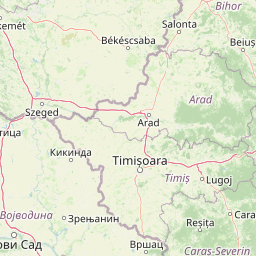
Subotička Peščara Protected Landscape offers a deep dive into an exceptional inland dune ecosystem, a key feature of Serbia's Pannonian Plain geography. This protected area's mapped terrain includes a mosaic of forest, steppe, and wetland habitats, supporting rare flora and fauna. Discover the unique contours of this aeolian landscape and its significance within the regional geographic context.

Area
53.7 km²
Established
2002
Relief
Lowland
Climate
Temperate
Watercolor illustration of a river landscape with grassy banks, trees, and hills in the background
National park

Danube-Drava National Park: Hungary's Premier Riverine Protected Area and Floodplain Landscape

Mapping the protected river corridors and vital wetland ecosystems

Danube-Drava National Park showcases the dynamic geography of Central Europe's largest riverine protected area, integrating floodplains, riparian woodlands, and extensive marshes along the Danube and Drava rivers. As a National Park and a Ramsar site, it protects crucial habitats like the Gemenc forest and supports exceptional biodiversity, including significant populations of white-tailed eagles. This page provides a structured overview of its mapped boundaries and ecological importance within the European protected lands atlas.

Area
490 km²
Established
1996
Relief
Lowland
Climate
Temperate
Protected area

Jegrička Nature Park: Mapped Protected Area with Riverine Wetland Ecosystems

Explore the geography and protected landscape of Jegrička Nature Park.

Jegrička Nature Park is a designated protected area recognized for its significant riverine wetland character within the Pannonian Plain of northern Serbia. The park's landscape is defined by the meandering Jegrička river, extensive marshlands, and riparian vegetation, serving as crucial freshwater habitat for diverse waterfowl and migratory bird populations. This page offers detailed geographic context and atlas-level exploration of its protected boundaries and ecological importance within Eastern Europe's broader natural heritage.

Relief
Lowland
Scope
Mixed
Water
Major water bodies
Watercolor illustration of a river flowing through wetland vegetation with distant hills under a light sky
Protected landscapeOsijek-Baranja County

Kopački Rit Protected Landscape: A Key European Wetland Ecosystem in Osijek-Baranja County

Mapped natural terrain and protected landscape geography.

Delve into the protected landscape of Kopački Rit, a pivotal European wetland situated within Osijek-Baranja County, Croatia. This page offers a detailed look at its dynamic floodplain ecosystem, mapped water channels, marshes, and riparian forests, highlighting its importance for biodiversity and regional geography. Understand the park's extensive protected boundaries and its place in the broader continental atlas.

Area
177 km²
Established
1976
IUCN
V
Relief
Lowland
Watercolor illustration of a river flowing through a valley with mountains in the background
National parkBékés County

Körös-Maros National Park: National Park Identity and Békés County Landscape Context

Explore its mapped protected areas, wetlands, and steppe grasslands.

Körös-Maros National Park is a designated national park located in Békés County, Hungary, recognized for its expansive wetland ecosystems and steppe grassland habitats. This protected area plays a critical role in the geography of the Southern Great Plain, serving as a vital migration corridor for diverse bird populations. Users can explore the park's distinct landscape features, mapped protected boundaries, and its significance as a hub for avian conservation.

Area
501.34 km²
Established
1997
Relief
Lowland
Climate
Temperate
Watercolor painting of a landscape featuring rolling hills, a lake, trees, and a sky with clouds
Natural monument

Avala Natural Monument: Iconic Protected Landscape and Regional Geography Near Belgrade

Explore Avala's mapped terrain and natural monument significance.

Avala Natural Monument offers a unique protected landscape and significant geographic context for the Belgrade metropolitan area. As one of Serbia's oldest protected natural sites, its distinct mountain terrain, geological composition, and panoramic views provide a rich subject for atlas-based discovery. Explore the mapped boundaries and natural features that define this prominent Serbian natural monument.

Area
5.01 km²
Established
1859
Relief
Mountain
Climate
Temperate
Watercolor illustration depicting a landscape with mountains, a winding river, and grassy fields
Protected landscape

Vršac Mountains Protected Landscape: A Unique Pannonian Island Mountain Range in Serbia

Explore distinct geological formations and rich avian habitats.

The Vršac Mountains Protected Landscape offers a unique geographic perspective as one of Serbia's Pannonian island mountains, emerging dramatically from the surrounding plains. This protected area is recognized for its striking gneiss and schist formations, its status as Vojvodina's highest elevation, and its exceptional importance for birdwatching, hosting over 120 species. Delve into the mapped terrain and geological character that distinguish this vital natural region.

Area
170 km²
Established
1982
Relief
Mountain
Climate
Temperate
National park

Balaton Uplands National Park: Mapped Volcanic Terrain and Protected Landscape Atlas

Explore Hungary's protected volcanic landscape and its regional geography.

Balaton Uplands National Park presents a compelling study in volcanic geography, showcasing dramatic 'witness mountains' and diverse terrains. As a protected national park in Hungary, it offers rich opportunities for atlas-style exploration of its mapped boundaries, unique basalt formations, and significant wetland areas. Discover the distinct geological narrative and landscape context of this protected region, providing a clear point of reference for understanding Hungary's natural heritage through structured geographic data.

Area
569.97 km²
Established
1997
Relief
Highland
Climate
Temperate

Common questions about visiting, size, designation, and location context for Lake Palić

Lake Palić FAQs for park facts, access, geography, and protected area context
Find quick answers about Lake Palić, including protected-area facts, park geography, trail and visitor context, and how the park fits into its surrounding country and regional landscape.
MoriAtlas Explorer

Continue Your Protected Areas Search Across the Global Atlas

Deepen your exploration by continuing the structured search for national parks and protected areas worldwide. Utilize the comprehensive filtering capabilities to compare different conservation landscapes and refine your understanding of global park geography. Discover more about the distribution and characteristics of protected natural areas.

Global natural geography