Mori Atlas logo
National parkKiskunság National Park

Discover the mapped boundaries and unique terrain of this Hungarian National Park's distinct ecosystems.

Kiskunság National Park: A Protected Landscape of Puszta Grassland and Alkaline Lakes in Hungary

(Kiskunsági Nemzeti Park)

Kiskunság National Park, established in 1975, represents a crucial protected landscape within Hungary's Great Hungarian Plain. This national park safeguards the rare puszta grassland ecosystem, characterized by its vast open steppes, alkaline lakes, and unique moving sand dunes. As Hungary's second national park, it spans seven disjoint territorial units, collectively preserving diverse habitats that are vital for migratory birds and offer a distinct geographic context for atlas exploration.

National ParkPuszta GrasslandWetlandsBirdwatchingSand DunesAlkaline Lakes
Stylized illustration of a waterfall in a mountainous landscape with a river flowing through a valley surrounded by forests of different tree types under a sky with a sun and clouds

Kiskunság National Park

National park

Park overview

Structured park overview, official facts, and landscape profile for Kiskunság National Park

Kiskunság National Park park facts, protected area profile, and essential visitor context
Review the core facts for Kiskunság National Park, including designation, size, terrain, visitor scale, habitats, and operating context in one park-focused overview.

About Kiskunság National Park

Kiskunság National Park stands as a testament to the harmonious coexistence between human communities and the natural environment on Hungary's Great Hungarian Plain. Established in 1975 as the country's second national park, the protected area encompasses approximately 530 square kilometers distributed across seven separate territorial units in the Little Cumania region. The park's landscape reflects the geological and ecological diversity of the Danube–Tisza Interfluve, a vast lowland corridor between the Danube and Tisza rivers. Unlike mountainous or forested protected areas common elsewhere in Europe, Kiskunság preserves a largely flat, open terrain characterized by alkaline grasslands, scattered lakes, sand dune systems, and marshland complexes. The park's significance was recognized internationally when UNESCO designated approximately two-thirds of its territory as a biosphere reserve in 1979, acknowledging both its ecological importance and its role in maintaining traditional land-use practices. The wetlands within the park fall under the Ramsar Convention, providing legal protection to some of Central Europe's most productive waterbird habitats. The park visitor center, known as the House of Nature, is located in Kecskemét, the largest city in Bács-Kiskun county.

Quick facts and research context for Kiskunság National Park

Kiskunság National Park occupies the Danube–Tisza Interfluve in the heart of the Great Hungarian Plain, protecting one of Hungary's most distinctive lowland landscapes. The park comprises seven separate territorial units rather than a single contiguous area. Its wetlands are designated under the Ramsar Convention, and the park serves as a critical ornithological site with avocaets, black-winged stilts, herons, and great bustards among the notable breeding species. The landscape features moving sand dunes near Fülöpháza, alkaline lakes with unique flora and fauna, and remnants of traditional pastoral Puszta terrain. The park administration is based in Kecskemét, with a visitor center called the House of Nature.

Park context

Deeper park guide and search-rich context for Kiskunság National Park

Kiskunság National Park history, landscape, wildlife, and travel context
Explore Kiskunság National Park through its history, landscape character, ecosystems, wildlife, conservation priorities, cultural context, and seasonal travel timing in a structured park guide built for atlas discovery and search intent.

Why Kiskunság National Park stands out

Kiskunság National Park is best known for its exceptional puszta landscape, a rare surviving example of the open grassland steppe ecosystem that once covered much of the Great Hungarian Plain. The park preserves one of Europe's most significant wetland complexes in this lowland setting, with a chain of alkaline lakes that serve as crucial staging grounds for migratory waterbirds. The moving sand dunes near Fülöpháza represent a geological phenomenon unique in Hungary, while the diverse birdlife, including great bustards, European rollers, black-winged stilts, and white-tailed eagles, makes the park a destination of particular importance for ornithologists. The park also maintains traditional Hungarian livestock breeds including Hungarian Grey cattle, Racka sheep, and Mangalica pigs, preserving the pastoral heritage of the region.

Close-up view of a spider orchid (Ophrys sp.) with yellow petals and dark red-brown labellum
Close-up of a spider orchid (Ophrys sp.) at Mekszikópuszta in Kiskunság National Park

Kiskunság National Park history and protected-area timeline

Kiskunság National Park was established on January 1, 1975, becoming Hungary's second national park following the creation of Hortobágy National Park in 1973. The establishment reflected a growing recognition of the ecological and cultural value of Hungary's puszta landscapes, which had been under increasing pressure from agricultural intensification throughout the twentieth century. The park was created to preserve the distinctive Great Hungarian Plain ecosystem and the traditional pastoral way of life that had shaped the landscape over centuries. In 1979, the park achieved international recognition when two-thirds of its territory was designated a UNESCO biosphere reserve under the Man and the Biosphere Programme, acknowledging both the area's ecological significance and its potential as a model for sustainable human-nature relationships. The designation under the Ramsar Convention followed, providing additional protection to the park's wetlands. The park administration, known as the Kiskunsági Nemzeti Park Igazgatóság, maintains its headquarters in Kecskemét and oversees the management of the seven disjoint territorial units that comprise the protected area.

Kiskunság National Park landscape and geographic character

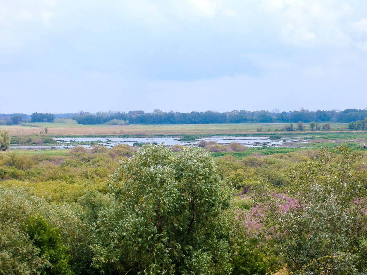
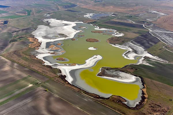
The landscape of Kiskunság National Park represents one of the most distinctive terrain types in Hungary—a flat, open lowland dominated by grassland, wetland, and sand dune ecosystems. The park lies in the Danube–Tisza Interfluve, a broad corridor of relatively low-lying land between the Danube and Tisza rivers on the Great Hungarian Plain. The terrain is predominantly flat with only subtle elevation changes, punctuated by distinct landscape features including the moving sand dunes near Fülöpháza, a rare geological phenomenon in Hungary where wind-blown sand creates actively shifting dune formations. Alkaline lakes scattered throughout the park, particularly near Fülöpszállás and Szabadszállás, create seasonal wetland habitats that fill with water during periods of high groundwater or spring flooding. The park also preserves sections of the dead Tisza river channel, known as Holt-Tisza, with their associated floodplain forests and marshes. The puszta landscape—open grassland with minimal tree cover—remains the defining visual character of much of the park, reflecting both the natural vegetation of the region and centuries of pastoral land use that prevented forest encroachment.

Wide view of a meadow landscape with a river, trees, and open fields under a partly cloudy sky
Meadow landscape within Kiskunság National Park

Kiskunság National Park ecosystems, habitats, and plant life

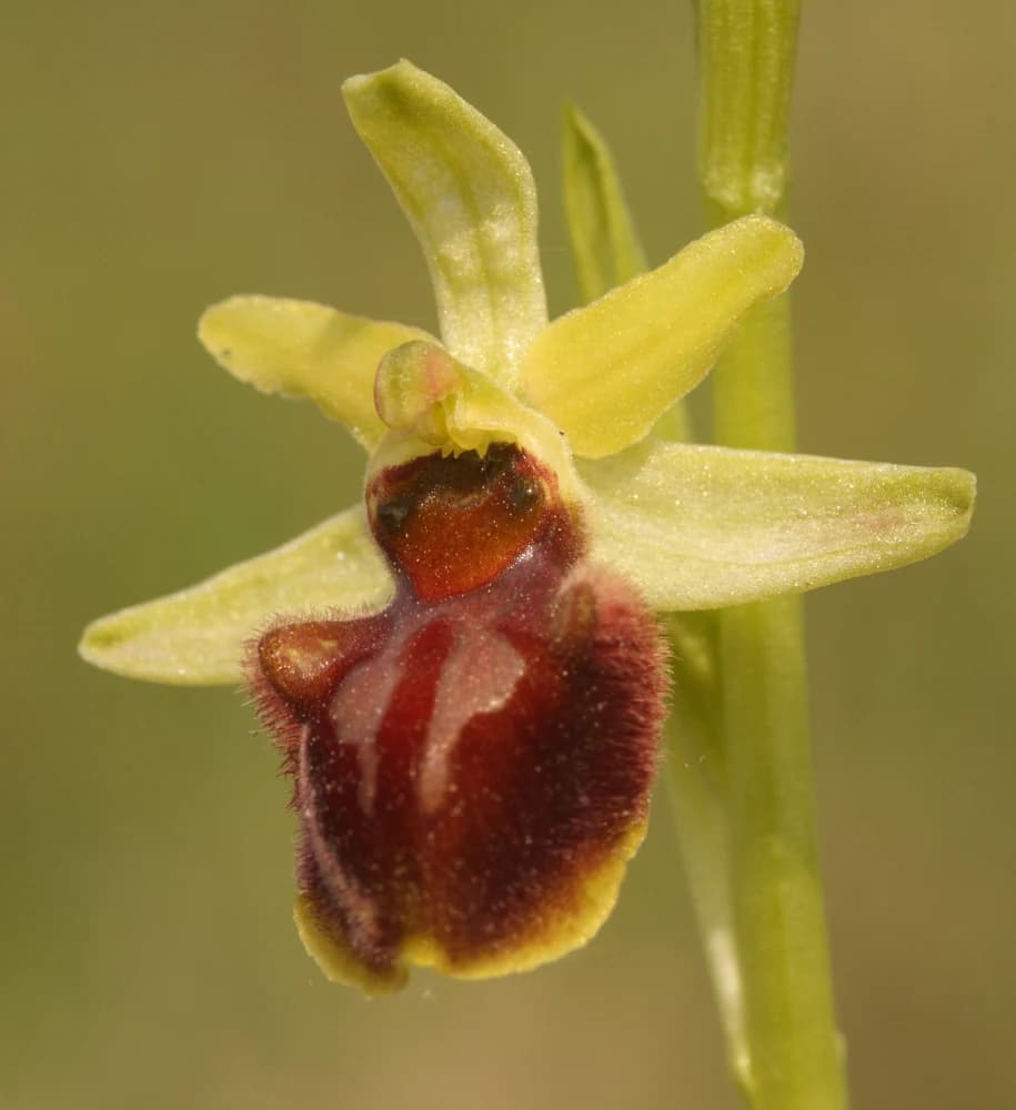
The ecological character of Kiskunság National Park centers on a complex mosaic of wetland and grassland habitats that support remarkable biodiversity in a lowland European context. The alkaline lakes of the Little Cumania, including Lake Szelid near Kalocsa, Lake Vadkert, Lake Fehér, and Lake Sós near Kiskunhalas, form a chain of interconnected wetlands that provide critical habitat for waterbirds and aquatic species. The moving sand dunes near Fülöpháza support specialized psammophilous (sand-loving) vegetation adapted to the unstable substrate, including species such as the kései szegfű (Dianthus giganteus) and sand-adapted insects. The marshland around Izsáki Kolon-tö has developed into extensive reed beds, willow carr, and fen vegetation supporting diverse communities of plants and birds. The alkaline grasslands, known locally as szikes puszta, feature salt-tolerant plant communities including red fescue, Hungarian saltwort, and wormwood species adapted to the high mineral content of the soil. Orchids occur in several locations, with nine species recorded in the vicinity of Lake Kolon, representing one of the most orchid-rich areas in Hungary's lowland regions.

Open grassland field with sparse trees, two birds in flight against a partly cloudy sky, distant hills visible
Open grasslands of Apajpuszta with birds in flight under a partly cloudy sky

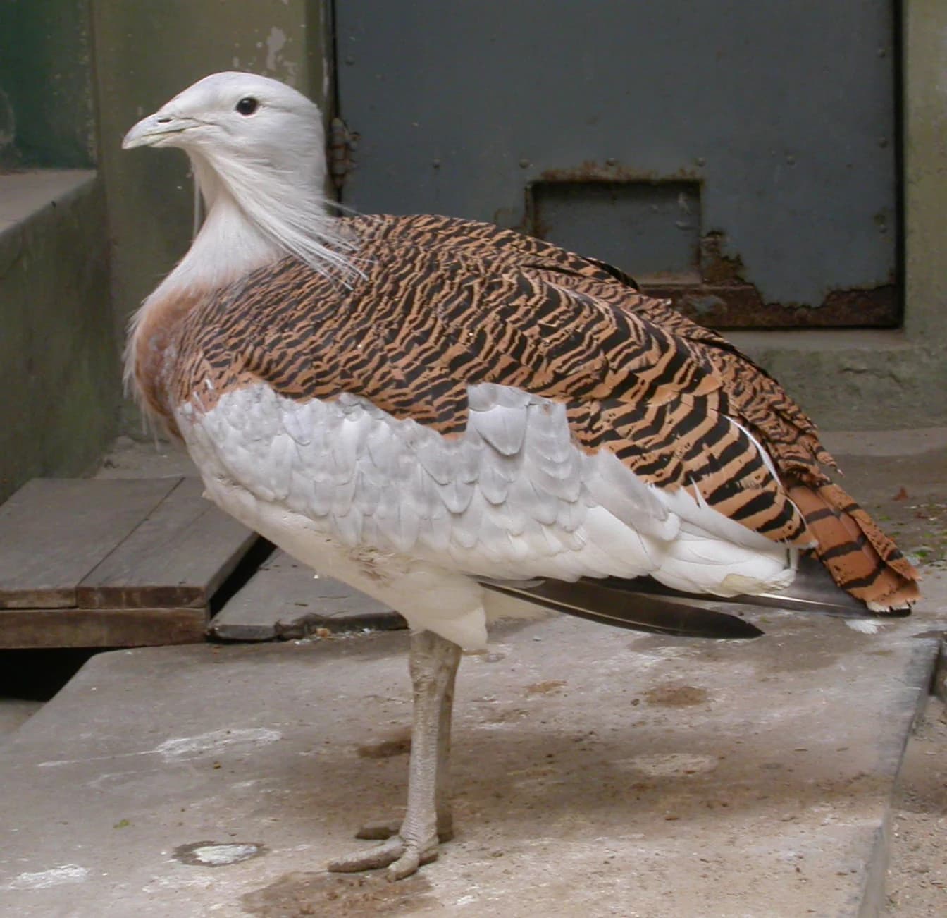
Kiskunság National Park wildlife and species highlights

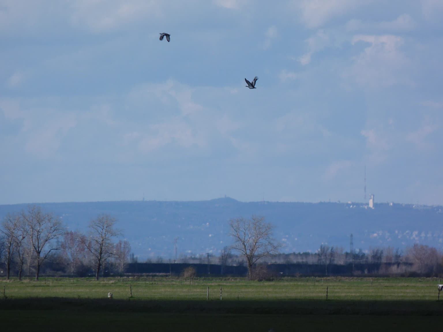
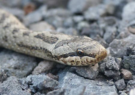
Kiskunság National Park supports exceptional bird populations that make it one of Hungary's most important ornithological sites. The alkaline lakes and marshes provide nesting habitat for significant populations of avocets, black-winged stilts, and various heron species including grey heron, purple heron, little egret, and great white egret. The park supports important breeding populations of great bustard, the heaviest flying bird in Europe, which nests in the open puszta grasslands. Birds of prey are well represented, with white-tailed eagle, saker falcon, and lesser spotted eagle among the notable raptor species. The grasslands support colonial nesting birds including the European roller, bee-eater, and various plover species. During migration, the wetland complexes host tens of thousands of migratory birds, providing crucial staging and feeding grounds for waterfowl moving between northern European breeding areas and southern wintering grounds. Among the reptile and amphibian populations, the marsh tortoise represents a species of particular conservation concern, while the smooth snake and various lizard species occupy the sandy and grassland habitats.

Aerial view of Kiskunság National Park with green and brown wetland areas, lakes, and surrounding fields
Aerial view of Kiskunság National Park showing wetlands, lakes, and agricultural fields

Kiskunság National Park conservation status and protection priorities

Kiskunság National Park serves as a critical conservation area for lowland ecosystems that have become increasingly rare across Central Europe. The park's designation as a UNESCO biosphere reserve reflects international recognition of its ecological significance and its successful integration of conservation with traditional land-use practices. The Ramsar Convention provides additional protection to the wetland habitats, ensuring that these crucial waterbird staging areas receive legal recognition at the international level. The conservation approach within the park reflects the unique character of the puszta landscape, where traditional pastoral practices—including the maintenance of Hungarian Grey cattle, Racka sheep, and Mangalica pig breeds—have shaped the ecosystem over centuries and remain compatible with habitat preservation objectives. Reintroduction of water buffalo at Nagyszéksós-tó in 2008 demonstrated innovative approaches to wetland management, with the animals' grazing and wallowing activities helping to maintain open water habitats and prevent succession to reedbed. The park also supports conservation programs for rare species including the Rákosi vipera (Vipera ursinii), one of Europe's rarest snakes, and various orchid species.

Kiskunság National Park cultural meaning and human context

Kiskunság National Park preserves a landscape where human communities and the natural environment have developed together over many centuries. The puszta ecosystem that defines much of the park's character is not merely a natural landscape but a cultural landscape shaped by generations of pastoral activity, cattle breeding, and traditional agriculture. The annual events held in the Kiskunság puszta revive the old pastoral life and cattle-breeding customs, maintaining living traditions that connect contemporary visitors to the historical relationship between local communities and their environment. The open-air museum at Ópusztaszer, located within the broader region served by the park, provides additional cultural context for understanding the human history of the Great Hungarian Plain. The landscape also holds significance in Hungarian history and legend, with the Pusztaszer area associated with traditions of the Hungarian conquest of the Carpathian Basin. The local communities of the Little Cumania region, centered on towns such as Kecskemét, Kiskunhalas, and Kalocsa, maintain cultural traditions distinct from other parts of Hungary, with the park playing a role in preserving both natural and cultural heritage.

Close-up view of a smooth snake with patterned scales resting on gray gravel and rocks
Smooth snake (Coronella austriaca) on rocky terrain

Top sights and standout views in Kiskunság National Park

Kiskunság National Park offers a distinctive Central European protected area experience centered on lowland grassland, wetland, and sand dune ecosystems rarely found elsewhere on the continent. The moving sand dunes near Fülöpháza provide a unique geological spectacle in Hungary, where visitors can observe the gradual migration of dunes shaped by wind action. The chain of alkaline lakes, particularly Lake Kolon near Izsák, supports remarkable concentrations of waterbirds and contains one of Hungary's richest orchid flora with nine species recorded in the vicinity. The great bustard population represents a conservation success story, with this impressive ground-nesting bird finding sanctuary in the open puszta grasslands. The park's seven territorial units each offer distinct experiences, from the floodplain forests of the Szikra area to the sand dune systems of the Fülöpháza region. The visitor center in Kecskemét provides an introduction to the park's ecology and cultural history, while marked trails and observation points throughout the park enable independent exploration of this distinctive lowland landscape.

Great Bustard with brown and white plumage standing on concrete
Great Bustard standing on a concrete surface

Best time to visit Kiskunság National Park

Kiskunság National Park can be visited throughout the year, though different seasons offer distinctly different experiences of the landscape. Spring, particularly April and May, brings migratory birds to the wetlands in large numbers, making this an excellent time for ornithological observation as waterfowl stage at the alkaline lakes before continuing their journeys. The summer months of June through August offer the fullest development of the park's vegetation, with flowering meadows and fully developed reed beds providing habitat for breeding birds and dragonflies. Autumn brings the departure of many migratory species and offers the opportunity to observe large flocks of waterbirds gathering before migration. Winter reveals a different character of the park, with the bare puszta landscape offering long sightlines across the open terrain and the possibility of observing roosting flocks of cranes and geese. The traditional pastoral events celebrating old cattle-breeding customs are typically held during the summer months, providing opportunities to experience living cultural traditions within the park landscape.

Park location guide

Geography guide, regional context, and park location map for Kiskunság National Park

Kiskunság National Park park geography, regions, and map view in Hungary
Understand where Kiskunság National Park sits in Hungary through a broader geographic reading of the surrounding landscape, nearby location context, and its mapped position within the national park landscape.

How Kiskunság National Park fits into Hungary

Hungary is a landlocked Central European country occupying the Carpathian Basin, also known as the Pannonian Basin. It borders Slovakia, Ukraine, Romania, Serbia, Croatia, Slovenia, and Austria. Budapest serves as both the capital and largest city. The population is predominantly ethnic Hungarians (Magyars), with Hungarian as the official language.

Wider geography shaping Kiskunság National Park in Hungary

Hungary occupies the Carpathian Basin in Central Europe, a large lowland plain surrounded by the Carpathian Mountains. It is bordered by Slovakia to the north, Ukraine to the northeast, Romania to the east and southeast, Serbia to the south, Croatia and Slovenia to the southwest, and Austria to the west. The Danube River flows through the country, providing its primary drainage.

Map view of Kiskunság National Park

Use this park location map to pinpoint Kiskunság National Park in Hungary, understand its exact geographic position, and read its mapped placement within the surrounding landscape more clearly.

Pigeon | © OpenStreetMap contributors

Location context for Kiskunság National Park

Bács-KiskunGreat Hungarian Plain

Understand the visual character of this Central European protected area, showcasing its vast grasslands, sand dunes, and critical wetland environments.

Kiskunság National Park Photos: Visual Guide to Hungary's Unique Puszta Landscapes and Wetlands
Browse a detailed visual atlas of Kiskunság National Park, showcasing its distinctive puszta grasslands, rare moving sand dunes, and critical alkaline lake habitats. These photographs provide essential geographic context, helping users understand the park's unique protected-area character and lowland Hungarian terrain.

Close-up view of a spider orchid (Ophrys sp.) with yellow petals and dark red-brown labellum

Aerial view of a salt lake with white salt deposits surrounding a central green body of water, surrounded by agricultural fields and green landscapes

Wide view of a meadow landscape with a river, trees, and open fields under a partly cloudy sky

Open grassland field with sparse trees, two birds in flight against a partly cloudy sky, distant hills visible

Aerial view of Kiskunság National Park with green and brown wetland areas, lakes, and surrounding fields

Black-winged Stilt (Himantopus himantopus) standing in shallow water with long pink legs and black-and-white plumage

Close-up view of a smooth snake with patterned scales resting on gray gravel and rocks

Great Bustard with brown and white plumage standing on concrete

Aerial view of Kiskunság National Park showing a brown water body, white salt flats, and green agricultural fields

Aerial view of Kolon Lake with surrounding wetlands and grasslands, showing islands and water channels

Aerial view showing sand dunes with winding paths and sparse vegetation in a flat, arid landscape

Aerial view of a flat grassy plain with scattered small water bodies and visible paths or trails

Park atlas

Discover additional national parks and protected landscapes across Hungary's Great Plain, complementing the unique puszta terrain of Kiskunság National Park.

Explore More National Parks and Protected Areas Near Kiskunság National Park in Hungary
Browse a selection of national parks and protected areas near Kiskunság National Park, revealing similar lowland grasslands, extensive wetlands, and distinct sand dune ecosystems across the Great Hungarian Plain. Compare unique geographic features and conservation landscapes, tracing the regional spread of Hungary's diverse protected zones for deeper atlas-style discovery.
Watercolor illustration of a river landscape with grassy banks, trees, and hills in the background
National park

Danube-Drava National Park: Hungary's Premier Riverine Protected Area and Floodplain Landscape

Mapping the protected river corridors and vital wetland ecosystems

Danube-Drava National Park showcases the dynamic geography of Central Europe's largest riverine protected area, integrating floodplains, riparian woodlands, and extensive marshes along the Danube and Drava rivers. As a National Park and a Ramsar site, it protects crucial habitats like the Gemenc forest and supports exceptional biodiversity, including significant populations of white-tailed eagles. This page provides a structured overview of its mapped boundaries and ecological importance within the European protected lands atlas.

Area
490 km²
Established
1996
IUCN
II
Relief
Lowland
Watercolor illustration of a winding river through grassy fields with wildflowers and distant hills
Protected landscape

Subotička Peščara Protected Landscape: A Mapped Inland Dune System in Serbia

Explore unique Pannonian Plain geography and rare habitats.

Subotička Peščara Protected Landscape offers a deep dive into an exceptional inland dune ecosystem, a key feature of Serbia's Pannonian Plain geography. This protected area's mapped terrain includes a mosaic of forest, steppe, and wetland habitats, supporting rare flora and fauna. Discover the unique contours of this aeolian landscape and its significance within the regional geographic context.

Area
53.7 km²
Established
2002
IUCN
V
Relief
Lowland
Watercolor illustration of Lake Palić showing a body of water with green and pink trees on the shore, rolling hills in the background
Protected areaSerbia

Lake Palić Protected Area: Serbia's Mapped Landscape and Regional Geography Exploration

Understand the protected landscape and park boundaries of Lake Palić.

Delve into the specifics of Lake Palić, a designated protected area in Serbia. This resource offers a deep dive into the park's mapped landscape, helping to illustrate its protected boundaries and geographic significance. Gain a clear understanding of its regional context and its contribution to the atlas of protected natural areas within Serbia.

IUCN
IV
National parkPest County

Danube-Ipoly National Park: Protected Landscape and Geographic Atlas

Mapping Hungary's diverse terrain and protected natural areas.

Delve into Danube-Ipoly National Park, a significant protected area renowned for its extraordinary ecological diversity. This page explores the park's distinct landscapes, from the volcanic formations of the Börzsöny Mountains to the deep karst cave systems of the Pilis, set against the backdrop of the Danube and Ipoly river floodplains. Understand its geographic placement within Pest County and its role as a vital protected landscape for conservation and atlas-based discovery.

Area
603.14 km²
Established
1997
IUCN
V
Relief
Mixed relief
National park

Balaton Uplands National Park: Mapped Volcanic Terrain and Protected Landscape Atlas

Explore Hungary's protected volcanic landscape and its regional geography.

Balaton Uplands National Park presents a compelling study in volcanic geography, showcasing dramatic 'witness mountains' and diverse terrains. As a protected national park in Hungary, it offers rich opportunities for atlas-style exploration of its mapped boundaries, unique basalt formations, and significant wetland areas. Discover the distinct geological narrative and landscape context of this protected region, providing a clear point of reference for understanding Hungary's natural heritage through structured geographic data.

Area
569.97 km²
Established
1997
IUCN
II
Relief
Highland
Watercolor illustration of a river flowing through a valley with mountains in the background
National parkBékés County

Körös-Maros National Park: National Park Identity and Békés County Landscape Context

Explore its mapped protected areas, wetlands, and steppe grasslands.

Körös-Maros National Park is a designated national park located in Békés County, Hungary, recognized for its expansive wetland ecosystems and steppe grassland habitats. This protected area plays a critical role in the geography of the Southern Great Plain, serving as a vital migration corridor for diverse bird populations. Users can explore the park's distinct landscape features, mapped protected boundaries, and its significance as a hub for avian conservation.

Area
501.34 km²
Established
1997
IUCN
V
Relief
Lowland
Watercolor illustration of a river flowing through wetland vegetation with distant hills under a light sky
Protected landscapeOsijek-Baranja County

Kopački Rit Protected Landscape: A Key European Wetland Ecosystem in Osijek-Baranja County

Mapped natural terrain and protected landscape geography.

Delve into the protected landscape of Kopački Rit, a pivotal European wetland situated within Osijek-Baranja County, Croatia. This page offers a detailed look at its dynamic floodplain ecosystem, mapped water channels, marshes, and riparian forests, highlighting its importance for biodiversity and regional geography. Understand the park's extensive protected boundaries and its place in the broader continental atlas.

Area
177 km²
Established
1976
IUCN
V
Relief
Lowland
Watercolor painting depicting grasslands, hills, and a body of water.
National park

Hortobágy National Park: A UNESCO Protected Steppe Landscape in Eastern Hungary

Explore the unique geography and mapped park boundaries of Hungary's first national park.

Hortobágy National Park is a monumental protected area in Eastern Hungary, recognized globally as the first national park established in the country and a UNESCO World Heritage site. This vast expanse of semi-natural grassland, known as the puszta, stretches across approximately 74,820 hectares, embodying over four millennia of pastoral traditions. The park's landscape is characterized by alkaline soils and sweeping horizons, offering a unique ecosystem with significant avian populations and preserved cultural landmarks. MoriAtlas provides structured geographic context and mapped details to understand this exceptional protected landscape.

Area
748.2 km²
Established
1973
IUCN
II
Relief
Lowland

Common questions about visiting, size, designation, and location context for Kiskunság National Park

Kiskunság National Park FAQs for park facts, access, geography, and protected area context
Find quick answers about Kiskunság National Park, including protected-area facts, park geography, trail and visitor context, and how the park fits into its surrounding country and regional landscape.
MoriAtlas Explorer

Continue Your Protected Areas Search Across the Global Atlas

Deepen your exploration by continuing the structured search for national parks and protected areas worldwide. Utilize the comprehensive filtering capabilities to compare different conservation landscapes and refine your understanding of global park geography. Discover more about the distribution and characteristics of protected natural areas.

Global natural geography