Mori Atlas logo
National parkHortobágy National Park

Discover the mapped geography and unique steppe ecosystem of Europe's largest semi-natural grassland.

Hortobágy National Park: Hungary's Vast Puszta Protected Landscape and UNESCO Heritage Site

Hortobágy National Park, established in 1973, represents Hungary's commitment to preserving its unique natural and cultural heritage. This expansive protected landscape, covering over 74,000 hectares, is celebrated as the largest semi-natural grassland in Europe. Its inscription as a UNESCO World Heritage site acknowledges the millennia-old pastoral traditions that have shaped its distinctive puszta ecosystem. Through MoriAtlas, users can explore the park's sweeping horizons, alkaline steppe soils, and the geographic context of this remarkable steppe landscape.

steppe grasslandUNESCO World HeritageRamsar sitebirdwatchingpastoral heritageEastern Hungary

Hortobágy National Park

National park

Park overview

Structured park overview, official facts, and landscape profile for Hortobágy National Park

Hortobágy National Park park facts, protected area profile, and essential visitor context
Review the core facts for Hortobágy National Park, including designation, size, terrain, visitor scale, habitats, and operating context in one park-focused overview.

About Hortobágy National Park

Hortobágy National Park represents a unique intersection of natural and cultural heritage in the heart of Central Europe. The park's designation as Hungary's first national park in 1973 reflected a recognition that this vast puszta landscape, though shaped by human activity over millennia, possessed irreplaceable ecological and cultural value that warranted formal protection. The UNESCO World Heritage inscription in 1999 acknowledged not merely a scenic landscape but a living cultural tradition stretching back more than four thousand years, where traditional pastoralism continues to define the character of the terrain. The park encompasses a complex mosaic of habitats including alkaline steppe, loess steppe, marshes, fishponds, floodplains, and remnant oak woodlands. This diversity supports remarkable biodiversity while maintaining the essential character that has defined the Hungarian Great Plain for centuries. The park administration, headquartered in Debrecen, manages not only the core protected area but also four landscape protection districts and nineteen separate nature conservation areas, creating an extensive network of protected territories spanning a significant portion of eastern Hungary. The park also operates Hungary's only passenger-carrying narrow-gauge railway, which runs to the Kondás fishpond, the country's largest artificial fishpond system.

Quick facts and research context for Hortobágy National Park

Hortobágy National Park occupies a lowland position in eastern Hungary across portions of Borsod-Abaúj-Zemplén, Heves, Hajdú-Bihar, and Jász-Nagykun-Szolnok counties. The park was established in 1973 as Hungary's inaugural national park and was designated a UNESCO World Heritage Site in 1999 under cultural criteria iv and v. The surrounding buffer zone spans approximately 199,380 hectares. The park was also recognized as a Ramsar Wetland site in 1979, protecting its marshlands and aquatic habitats. The park serves as a dark sky preserve and manages an extensive network of fishponds, marshlands, and restoration areas.

Park context

Deeper park guide and search-rich context for Hortobágy National Park

Hortobágy National Park history, landscape, wildlife, and travel context
Explore Hortobágy National Park through its history, landscape character, ecosystems, wildlife, conservation priorities, cultural context, and seasonal travel timing in a structured park guide built for atlas discovery and search intent.

Why Hortobágy National Park stands out

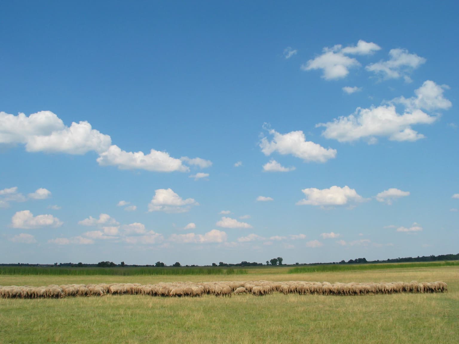
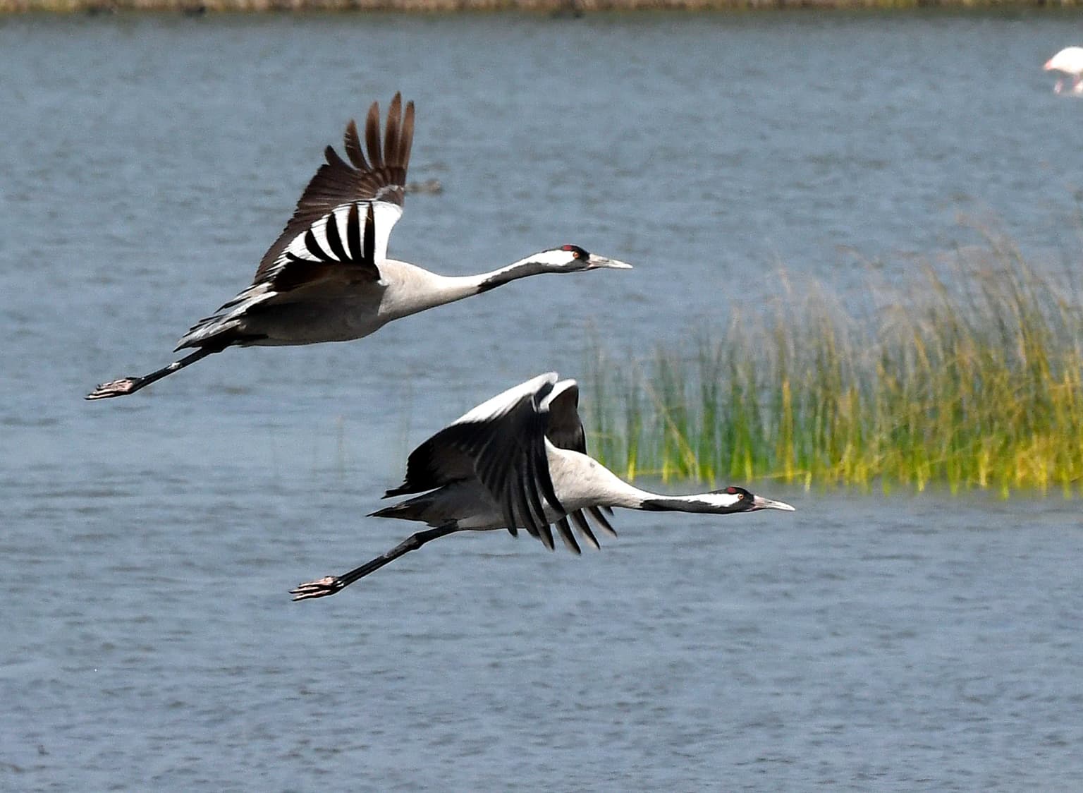
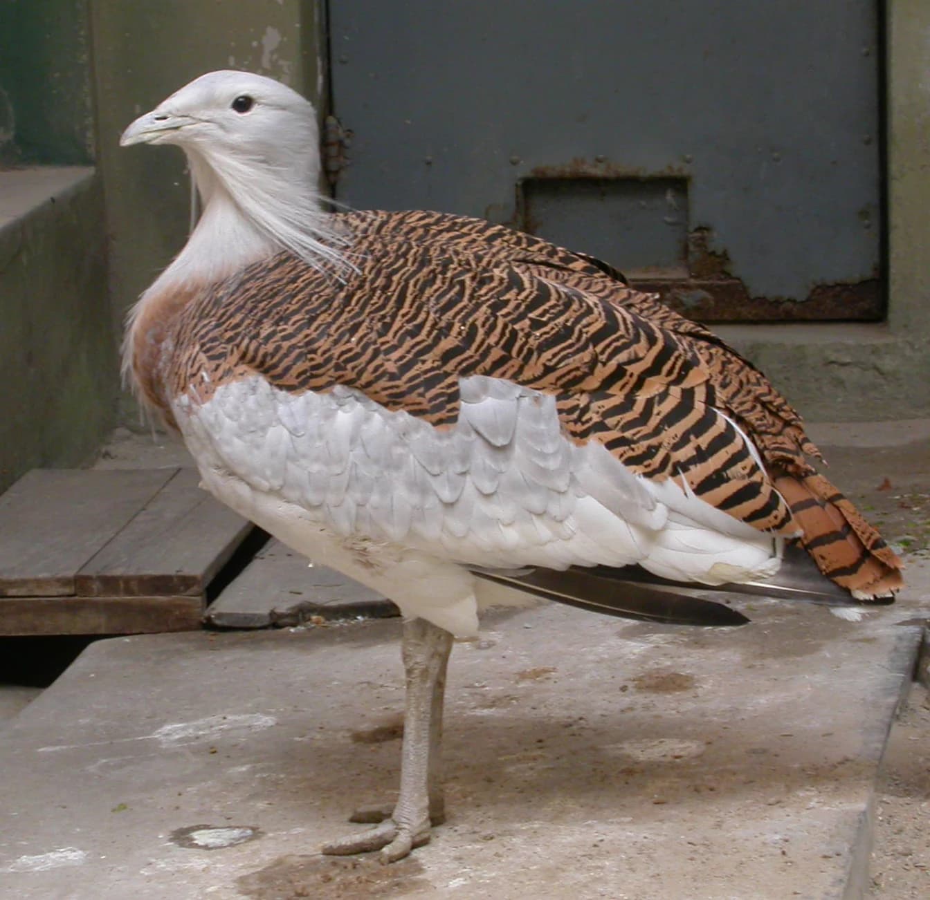
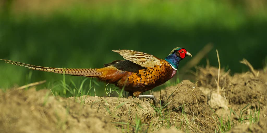
Hortobágy is best known for its intact puszta landscape, a rolling, treeless steppe that represents one of the last remaining semi-natural grasslands of its kind in Europe. The park preserves one of the continent's most significant bird migration stopover sites, with over 340 species recorded, including the red-footed falcon, great bustard, and white stork. The traditional pastoral practices remain active, with mounted herdsmen (csikós) still tending Hungarian Grey cattle, Racka sheep, and water buffalo across the open ranges. The Nine-holed Bridge, a traditional stone bridge with nine arches, stands as an iconic symbol of the park, while T-shaped sweep wells (gémeskút) punctuate the landscape as distinctive cultural landmarks.

Hortobágy National Park history and protected-area timeline

The formation of the Hortobágy landscape is considerably older than previously assumed. While it was long believed that the alkaline steppe resulted from medieval deforestation followed by river control measures, current understanding indicates that alkalinization began approximately ten thousand years ago when the Tisza River first found its path through the Great Hungarian Plain, cutting off streams from their sources in the Northern Mountains. The distinctive soil characteristics were further developed by grazing animals and wild horses during the Ice Age, followed by domesticated livestock. The site has supported human habitation and pastoral activity for over four millennia, with archaeological evidence of continuous cultural presence. Under the communist regime, the park unfortunately served as a site of forced labor, a dark chapter in its history that has been acknowledged but does not define the park's broader significance. The establishment of the national park in 1973 marked a turning point in Hungarian nature conservation, creating an institutional framework for protecting this unique landscape. The UNESCO World Heritage inscription in 1999 elevated the park's international recognition, while the Ramsar designation in 1979 acknowledged the importance of its wetland habitats.

Hortobágy National Park landscape and geographic character

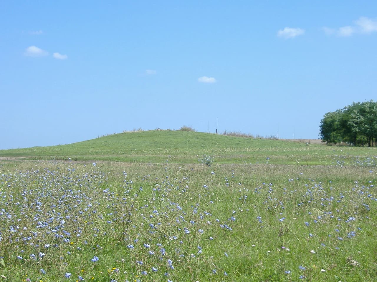
The physical landscape of Hortobágy presents an expansive, nearly flat terrain that stretches to the horizon in all directions, broken only by occasional low mounds and the distinctive features of traditional human structures. The terrain is almost completely flat, with the landscape resembling a vast carpet across which the Hortobágy River winds as a silvery ribbon through its center. The most notable topographic features are the kunhalmok, or kurgans—artificial mounds created by nomadic peoples arriving from the eastern steppes during the Middle Copper Age, serving as watchtowers, burial sites, and territorial markers. The soil composition is predominantly alkaline (szikesek), with mineral salts accumulating in the upper soil layers following the extensive drainage and river regulation projects of the 19th century. The landscape supports four primary habitat types: alkaline puszta, loess puszta, marshes, and floodplains. The fishpond systems, particularly around the Kondás area, create extensive bodies of shallow water that support rich aquatic and birdlife communities.

Hortobágy National Park ecosystems, habitats, and plant life

The ecological character of Hortobágy is defined by its steppe vegetation communities, which persist despite the region not being a true climatic steppe—the distinctive alkaline conditions created by the soil's chemical properties allow grassland communities to thrive. The vegetation includes loess steppe grasslands on the flatter ridges and kunhalom mounds, characterized by species such as Festuca rupicola, Elymus hispidus, and Stipa capillata. The alkaline puszta communities support salt-tolerant species including Aster tripolium ssp. pannonicum and Peucedanum officinale. The marshes and fishpond margins support reed beds, sedge communities, and aquatic vegetation including water lily species. Remnant oak woodlands (sziki tölgyesek) survive at the park's edges, particularly in the Ohat Forest and the Tilalmas Forest near Újszentmargita, where spring wildflowers including Pulsatilla, Corydalis, and Iris species create seasonal displays. The alkaline conditions have produced a distinctive flora with species adapted to high pH and salinity, creating vegetation communities found nowhere else in Hungary.

Hortobágy National Park wildlife and species highlights

Hortobágy supports an extraordinary diversity of wildlife, with particular significance attached to its bird communities. Over 340 bird species have been recorded within the park, making it one of the most important ornithological sites in Europe. The breeding bird community includes significant populations of red-footed falcon, stone curlew, great bustard, European roller, saker falcon, eastern imperial eagle, European bee-eater, great egret, white stork, black stork, and many others. The wetlands and fishponds support heronries, cormorant colonies, and diverse waterbird communities. The park serves as a critical stopover site for migratory species, with tens of thousands of birds passing through during spring and autumn migrations, including common crane, dotterel, and lesser white-fronted goose. The mammalian fauna includes roe deer, European wildcat, red fox, and European ground squirrel. The park maintains conservation herds of traditional domestic animals including Hungarian Grey cattle, Racka sheep, water buffalo, and Nonius horses. A small herd of approximately 25 Przewalski's horses has been established, representing efforts to maintain the ecological roles of wild equids. The park also supports a breeding program for Taurus cattle, one of several projects attempting to recreate the extinct aurochs.

Hortobágy National Park conservation status and protection priorities

Hortobágy's conservation significance stems from its role as Europe's largest remaining semi-natural grassland and a model of cultural landscape preservation. The UNESCO World Heritage designation specifically recognized the site's testimony to traditional pastoralism and its outstanding universal value as a cultural landscape. As a Ramsar Wetland site, the park's aquatic habitats receive international protection under the Convention on Wetlands, with waterbird hunting prohibited throughout the year in designated areas. The park's status as a biosphere reserve integrates nature conservation with sustainable traditional land uses, allowing for the continuation of grazing practices that maintain the open grassland character. The conservation approach acknowledges that the puszta is not a pristine wilderness but a cultural landscape where traditional pastoral practices are essential for maintaining the ecological character—the continued presence of grazing animals prevents the succession to scrub and woodland that would otherwise occur. The park participates in European conservation networks and supports research into steppe ecology, traditional breed conservation, and sustainable pastoral management.

Hortobágy National Park cultural meaning and human context

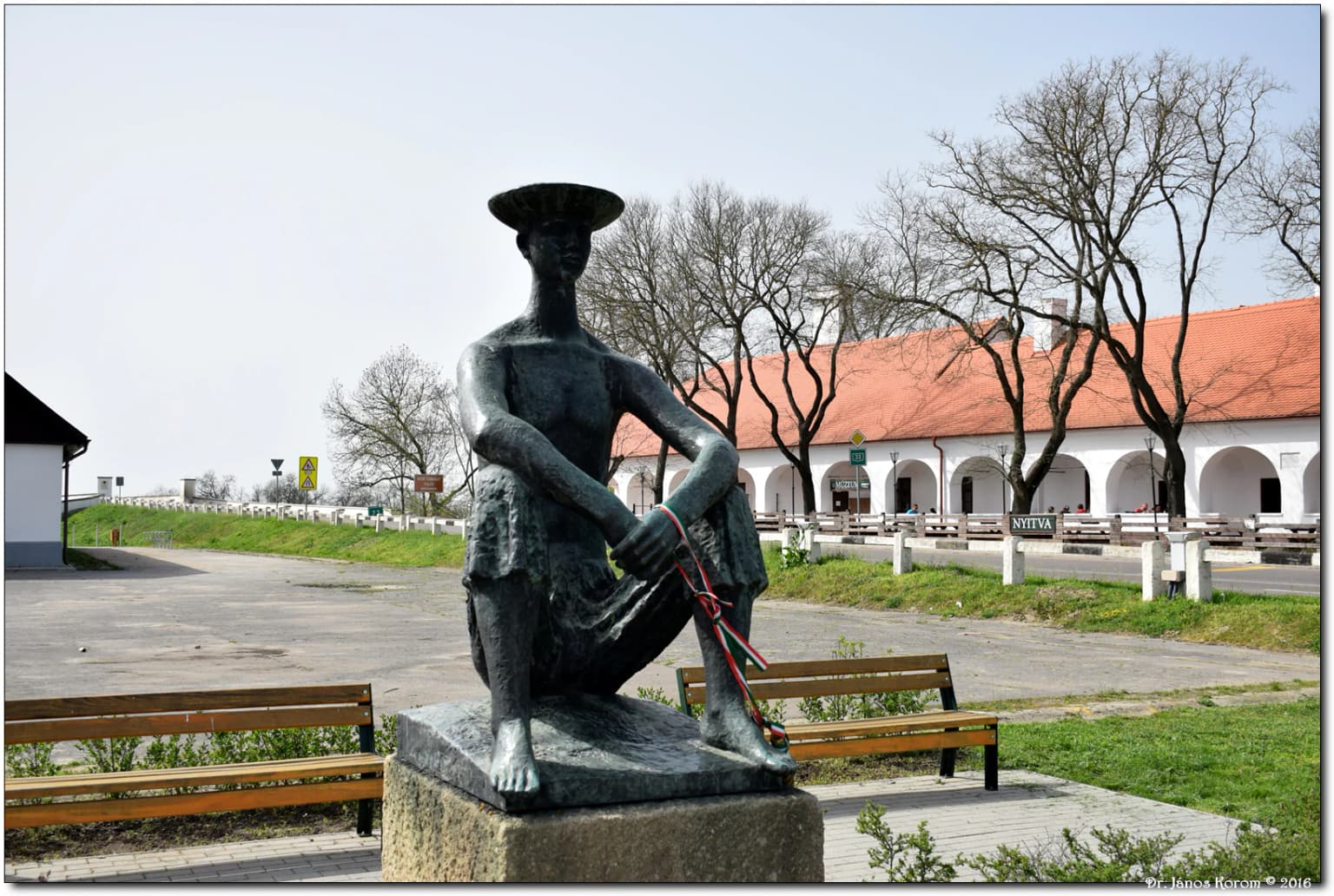
The cultural landscape of Hortobágy represents one of Europe's most intact expressions of traditional pastoral life, a heritage that defines Hungarian national identity. The puszta has been shaped by generations of herders, with the csikós (mounted herdsmen) remaining an iconic figure in Hungarian folklore and cultural imagination. The landscape preserves numerous traditional structures including the distinctive T-shaped sweep wells (gémeskút), which were essential for watering livestock, and the Nine-holed Bridge (Kilenclyukú híd), a stone bridge with nine arches that has become the park's most recognizable landmark. The region retains traditional animal breeds including the Hungarian Grey cattle, known for their distinctive curved horns, the Racka sheep with its double-horned profile, and the Nonius horse breed. The cuisine, music, and traditions of the puszta have profoundly influenced Hungarian cultural identity. The name Hortobágy itself derives from Hungarian words meaning 'long and wide' or 'extended grazing land,' directly referencing the landscape's pastoral heritage.

Top sights and standout views in Hortobágy National Park

The Nine-holed Bridge stands as the park's most iconic structure, a nine-arch stone bridge that has become synonymous with the Hortobágy landscape. The traditional sweep wells, with their distinctive T-shaped wooden frames, dot the puszta as functional cultural landmarks. The bird migration spectacle in spring and autumn draws tens of thousands of cranes and geese, creating one of Europe's most impressive wildlife spectacles. The traditional animal breeds—Hungarian Grey cattle, Racka sheep, and Nonius horses—still graze the open ranges in patterns that have changed little for centuries. The park's dark sky preserve offers exceptional opportunities for stargazing in one of Europe's few truly dark locations. The narrow-gauge railway connecting the park to the Kondás fishpond provides a unique visitor experience while serving as a working fishpond railway.

Best time to visit Hortobágy National Park

The park can be enjoyed throughout the year, though each season offers distinct characteristics. Spring brings the bird migration spectacle, with cranes, geese, and numerous waterfowl passing through in large numbers, while the warmer months see active pastoral activities with herds grazing across the open puszta. Summer offers long daylight hours and the classic puszta atmosphere, though mid-summer heat can be intense on the exposed plain. Autumn again features impressive bird migrations, particularly the crane and goose passages, and the golden light creates particularly striking landscapes. Winter reveals a different character, with snow-covered puszta offering stark, minimalist beauty, though some facilities may have reduced operations. The shoulder seasons of late spring and early autumn generally offer the most comfortable conditions for exploration and wildlife observation.

Park location guide

Geography guide, regional context, and park location map for Hortobágy National Park

Hortobágy National Park park geography, regions, and map view in Hungary
Understand where Hortobágy National Park sits in Hungary through a broader geographic reading of the surrounding landscape, nearby location context, and its mapped position within the national park landscape.

How Hortobágy National Park fits into Hungary

Hungary is a landlocked Central European country occupying the Carpathian Basin, also known as the Pannonian Basin. It borders Slovakia, Ukraine, Romania, Serbia, Croatia, Slovenia, and Austria. Budapest serves as both the capital and largest city. The population is predominantly ethnic Hungarians (Magyars), with Hungarian as the official language.

Wider geography shaping Hortobágy National Park in Hungary

Hungary occupies the Carpathian Basin in Central Europe, a large lowland plain surrounded by the Carpathian Mountains. It is bordered by Slovakia to the north, Ukraine to the northeast, Romania to the east and southeast, Serbia to the south, Croatia and Slovenia to the southwest, and Austria to the west. The Danube River flows through the country, providing its primary drainage.

Map view of Hortobágy National Park

Use this park location map to pinpoint Hortobágy National Park in Hungary, understand its exact geographic position, and read its mapped placement within the surrounding landscape more clearly.

Pigeon | © OpenStreetMap contributors

Location context for Hortobágy National Park

Borsod-Abaúj-Zemplén CountyHajdú-Bihar CountyHeves CountyJász-Nagykun-Szolnok County
Park atlas

Trace the geographic spread of protected landscapes surrounding Hortobágy National Park

Discover Other Protected Areas and National Parks Near Hortobágy National Park
Browse a curated selection of national parks and protected areas found in the vicinity of Hortobágy National Park, tracing the regional geography of Hungary's expansive Great Plain. This view facilitates direct comparison of diverse protected landscapes and unique conservation zones, deepening your understanding of Central European park contexts.
Watercolor painting of a wetland with a calm lake, reeds, and distant forested hills
Protected landscapeBihor County

Cefa Natural Park Protected Landscape: Atlas and Geographic Context

Mapped wetland habitats and European bird migration routes.

Cefa Natural Park, designated as a protected landscape in Bihor County, Romania, offers significant insight into European wetland ecosystems and migratory bird patterns. Spanning 5,002 hectares, it features critical habitats such as marshes, floodplains, and the Rădvani Forest, positioned directly on the Pannonian, Bulgarian migration corridor. This park is a landmark for understanding regional geography and conservation efforts focused on migratory waterfowl and specialized halophytic vegetation. MoriAtlas provides the structured geographic data and mapped context necessary for detailed atlas-based discovery of this important protected area.

Area
50.02 km²
Established
2010
IUCN
V
Relief
Lowland
Watercolor painting showing a winding river, green trees, distant hills, and grassy foreground
National park

Aggtelek National Park

Karst Landscape & Cave Systems

Explore the protected area of Aggtelek National Park, a UNESCO World Heritage site known for its extensive karst landscapes and significant cave systems. Understand its geographic setting and protected land status.

Area
198.92 km²
Established
1985
IUCN
II
Relief
Mixed relief
Watercolor illustration of a river flowing through a valley with mountains in the background
National parkBékés County

Körös-Maros National Park: National Park Identity and Békés County Landscape Context

Explore its mapped protected areas, wetlands, and steppe grasslands.

Körös-Maros National Park is a designated national park located in Békés County, Hungary, recognized for its expansive wetland ecosystems and steppe grassland habitats. This protected area plays a critical role in the geography of the Southern Great Plain, serving as a vital migration corridor for diverse bird populations. Users can explore the park's distinct landscape features, mapped protected boundaries, and its significance as a hub for avian conservation.

Area
501.34 km²
Established
1997
Relief
Lowland
Climate
Temperate
National parkKošice Region

Slovak Karst National Park: Premier Central European Karst Landscape and Cave Systems

Explore protected terrain and mapped underground wonders in Košice Region.

Slovak Karst National Park offers an unparalleled glimpse into a dynamic karst environment. As a designated national park and UNESCO Biosphere Reserve, it preserves a significant concentration of caves, dramatic limestone formations, and rugged canyons within its territory in southeastern Slovakia. This atlas-focused presentation highlights the park's distinctive geology, mapped landscape features, and its importance as a protected natural area within the broader geography of the Košice Region. Understand the park's surface topography and its world-renowned subterranean realms.

Area
346.11 km²
Established
2002
IUCN
II
Relief
Mountain
Watercolor illustration of a winding river through rolling green hills with trees in the foreground
National parkKošice Region

Slovak Paradise National Park: Protected Area Mapping & Geographic Context in Košice Region

Explore the boundaries and terrain of this national park.

Investigate Slovak Paradise National Park, a designated national park situated within Slovakia's Košice Region. This detailed entry provides essential context for understanding its protected landscape features, mapped geographic distribution, and role within regional atlas exploration. Discover its unique terrain and boundaries to build a comprehensive view of Slovak conservation areas.

Area
197.63 km²
Established
1988
IUCN
II
Relief
Mountain
National parkBanská Bystrica Region

Muránska planina National Park: Discover Slovakia's Karst Plateau and Protected Natural Landscape

Explore mapped boundaries, caves, and endemic flora in Banská Bystrica Region.

Muránska planina National Park represents a significant protected landscape in central Slovakia's Banská Bystrica Region, defined by its extensive karst topography. This national park encompasses a limestone and dolomite plateau rich with geological wonders, including over 150 caves, sinkholes, and karst springs. The unique contrast between the flat plateau surface and the sharp, rocky ravines showcases a dramatic natural terrain. Explore the park's mapped boundaries and its remarkable biodiversity, highlighted by 35 endemic species and rare Tertiary relict flora like Daphne arbuscula, making it a key destination for atlas-based geographic discovery.

Area
213.18 km²
Established
1997
IUCN
II
Relief
Mountain
National parkZakarpattia Oblast

Zacharovanyi Krai National Nature Park: Protected Landscape Atlas Entry

National park within Zakarpattia Oblast, Ukraine

Navigate Zacharovanyi Krai National Nature Park, a designated national park offering vital insights into protected landscapes and regional geography. This entry provides core information about the park's protected area status and its geographic setting within Zakarpattia Oblast, essential for structured atlas discovery and understanding the mapped natural terrain of western Ukraine.

Area
61.01 km²
Established
2009
IUCN
II
Relief
Mountain
National parkPest County

Danube-Ipoly National Park: Protected Landscape and Geographic Atlas

Mapping Hungary's diverse terrain and protected natural areas.

Delve into Danube-Ipoly National Park, a significant protected area renowned for its extraordinary ecological diversity. This page explores the park's distinct landscapes, from the volcanic formations of the Börzsöny Mountains to the deep karst cave systems of the Pilis, set against the backdrop of the Danube and Ipoly river floodplains. Understand its geographic placement within Pest County and its role as a vital protected landscape for conservation and atlas-based discovery.

Area
603.14 km²
Established
1997
Relief
Mixed relief
Climate
Temperate

Common questions about visiting, size, designation, and location context for Hortobágy National Park

Hortobágy National Park FAQs for park facts, access, geography, and protected area context
Find quick answers about Hortobágy National Park, including protected-area facts, park geography, trail and visitor context, and how the park fits into its surrounding country and regional landscape.
MoriAtlas Explorer

Continue Your Protected Areas Search Across the Global Atlas

Deepen your exploration by continuing the structured search for national parks and protected areas worldwide. Utilize the comprehensive filtering capabilities to compare different conservation landscapes and refine your understanding of global park geography. Discover more about the distribution and characteristics of protected natural areas.

Global natural geography