Mori Atlas logo
National parkSlovak Karst National Park

Discover the dramatic terrain and subterranean world of this significant Slovak national park.

Slovak Karst National Park: Mapped Protected Landscape and Central European Karst Atlas

(Národný park Slovenský kras)

Slovak Karst National Park, situated in southeastern Slovakia within the Košice Region, is a premier destination for exploring one of Central Europe's most complex karst landscapes. This protected area, recognized as a UNESCO Biosphere Reserve, encompasses vast limestone formations, dramatic canyons, and an extraordinary network of underground caves that represent a significant portion of Slovakia's subterranean wonders. Delve into the park's unique terrain, from sculpted surface plateaus to deep gorges, and understand its vital role in regional geography and conservation through detailed map context.

karst landscapecave systemsUNESCO World Heritage Sitebiosphere reservelimestone formationsnational park

Slovak Karst National Park

National park

Park overview

Structured park overview, official facts, and landscape profile for Slovak Karst National Park

Slovak Karst National Park park facts, protected area profile, and essential visitor context
Review the core facts for Slovak Karst National Park, including designation, size, terrain, visitor scale, habitats, and operating context in one park-focused overview.

About Slovak Karst National Park

Slovak Karst National Park represents a treasure trove of natural and geological heritage in the heart of the Carpathian Mountains. The park protects a landscape shaped over millions of years by water dissolving limestone, creating an intricate underworld of caves, sinkholes, and underground streams that rank among the most significant in Europe. Above ground, visitors encounter a landscape of stark beauty—limestone plateaus rise like islands above surrounding valleys, their edges marked by sheer cliffs and rocky outcrops. Deep canyons cut through the terrain, their walls adorned with rare plants adapted to the harsh microclimates of karst cliffs. The region has drawn scientific attention since the 18th century, when early explorers began documenting its caves and geological features. Today, the park provides a living laboratory for geologists, biologists, and speleologists studying karst processes and the unique ecosystems they support. The park's designation as a biosphere reserve reflects the successful integration of conservation with sustainable use of natural resources, as the surrounding agricultural communities maintain traditional practices that complement rather than conflict with protection goals. The karst landscape also holds cultural significance, with evidence of human presence in caves spanning from prehistoric times through medieval periods when some caves served as refuges and religious sites.

Quick facts and research context for Slovak Karst National Park

Slovak Karst National Park is located in southeastern Slovakia within the Košice region, spanning the Gelnica, Rožňava, and Košice-okolie districts. The park covers 346.11 square kilometers with an additional 117.41 square kilometer buffer zone. The highest peak is Matesova skala at 925 meters above sea level. The region has been protected since 1973 as a protected landscape area, achieving national park status in 2002. The park serves as Slovakia's first UNESCO biosphere reserve and contains a World Heritage-listed cave system. Approximately 78 percent of the park is covered by forest. The administration is based in the village of Brzotín.

Park context

Deeper park guide and search-rich context for Slovak Karst National Park

Slovak Karst National Park history, landscape, wildlife, and travel context
Explore Slovak Karst National Park through its history, landscape character, ecosystems, wildlife, conservation priorities, cultural context, and seasonal travel timing in a structured park guide built for atlas discovery and search intent.

Why Slovak Karst National Park stands out

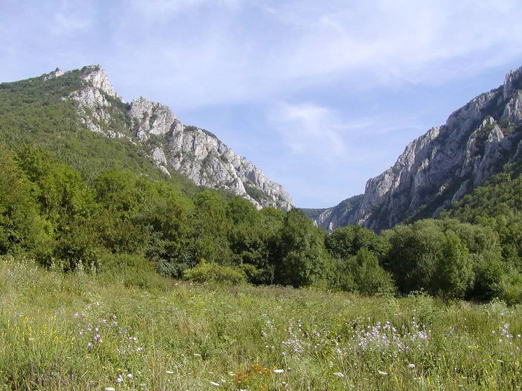
Slovak Karst is best known for its extraordinary karst geology, featuring one of the most complex and well-developed cave systems in Central Europe. The Zádielska tiesňava canyon represents one of the park's most spectacular surface features, with its sheer limestone walls and dramatic gorge. The underground realm is equally impressive, the Skalistý potok cave system stretches over 7.9 kilometers with a vertical depth of 373 meters, making it the longest and deepest cave in the Slovak Karst region. Twelve caves within the park form part of the UNESCO World Heritage Site recognized in 1995. The region also stands out for its biological diversity, supporting all of Slovakia's large carnivores including brown bears, wolves, and lynx, alongside remarkable populations of birds of prey and bats.

Rocky mountain cliffs, green meadows, and dense forests in Zadiel Canyon.
Zadiel Canyon within Slovak Karst National Park, featuring rocky cliffs, lush green forests, and a meadow under a partly cloudy sky.

Slovak Karst National Park history and protected-area timeline

The protection of Slovak Karst evolved over several decades before achieving national park status in 2002. The area was first designated as a protected landscape area (CHKO) in 1973, recognizing the region's outstanding natural and geological values. This initial protection came after decades of increasing scientific documentation of the area's caves and karst features. A pivotal moment in the region's recognition came on March 1, 1977, when Slovak Karst became Slovakia's first biosphere reserve under UNESCO's Programme on Man and the Biosphere, acknowledging both the ecological significance and the traditional human relationships with this landscape. In 1995, the caves of Slovak Karst and the neighboring Aggtelek Karst in Hungary were inscribed as a UNESCO World Heritage Site, recognizing their outstanding universal value as one of the world's most significant cave systems. The transition to national park status in 2002 reflected Slovakia's commitment to stronger conservation measures for its most valuable landscapes. The park administration, based in Brzotín, manages not only the core national park territory but also numerous small protected areas within its boundaries, including ten national nature reserves, six nature reserves, and sixteen national nature monuments, most of which are cave systems.

Slovak Karst National Park landscape and geographic character

The landscape of Slovak Karst National Park is defined by its karst geology—limestone and dolomite bedrock that has been sculpted by water into a complex terrain of caves, sinkholes, disappearing streams, and karst springs. The terrain is characterized by a succession of elevated limestone plateaus separated by deep valleys and canyons. The Silická planina, Horný vrch, and Dolný vrch represent the main plateau formations, their surfaces marked by karst features including karren fields, sinkholes, and disappearing streams. Between these plateaus, the landscape drops into steep-sided valleys, none more dramatic than Zádielska tiesňava, a spectacular gorge with limestone walls rising tens of meters above the stream below. The highest point in the park, Matesova skala, reaches 925 meters above sea level, though most of the protected area lies at moderate elevations. The underlying geology creates distinctive drainage patterns—surface streams frequently disappear underground through swallow holes, traveling through cave systems before reemerging as springs in valleys or at the bases of cliffs. This karst hydrology supports unique ecosystems both above and below ground, with the caves providing stable environments for specialized species and the surface landscapes hosting diverse habitats from forested slopes to rocky cliffs and karst meadows.

Slovak Karst National Park ecosystems, habitats, and plant life

The ecological diversity of Slovak Karst reflects both its varied surface terrain and the unique underground environments created by its karst geology. Forest covers approximately 78 percent of the park, with mixed deciduous and coniferous forestsclimbing the slopes between the limestone plateaus. These forests transition with elevation, supporting species typical of central European mountain environments. The karst landscape creates highly specialized habitats—the bare limestone surfaces of cliffs and plateaus support communities of drought-resistant plants, while the cool, humid environments of cave entrances host entirely different assemblages. The region's position at the meeting point of different climatic influences contributes to species diversity, with elements from western, eastern, and southern Europe meeting here. Particularly notable is the subterranean ecosystem, where cave systems support specialized fauna adapted to life in complete darkness, including numerous species of bats, cave-dwelling invertebrates, and unique troglobitic organisms. The karst wetlands, though limited in extent, provide critical habitats for specialized plants and invertebrates adapted to temporary flooding and the unique chemistry of karst water.

Slovak Karst National Park wildlife and species highlights

Slovak Karst supports an impressive community of wildlife, with all of Slovakia's large carnivores present within the park's boundaries. Brown bears, wolves, and Eurasian lynx all maintain populations here, representing some of the most significant predator communities in central Europe. These species benefit from the park's extensive forest cover and the connectivity to surrounding landscapes that allows for natural movement and genetic exchange. The bird population is particularly notable, with golden eagles, white-tailed sea eagles, and black storks among the characteristic species of the rocky cliffs and forest edges. The bat fauna is exceptionally rich—nearly all species found in Slovakia have been recorded in the park, with the numerous caves providing critical roosting and hibernation sites. Reptiles and amphibians are well represented, including both tree and smooth snakes, several lizard species, and diverse amphibian communities ranging from common frogs to fire salamanders. The cave systems themselves support specialized subterranean fauna, with various invertebrate species adapted to life in the dark, damp underground environment. This rich wildlife community reflects both the quality of protection within the park and the importance of the broader karst landscape as a wildlife corridor through the eastern Slovak lowlands.

Slovak Karst National Park conservation status and protection priorities

Slovak Karst holds exceptional conservation significance at both national and international levels. As Slovakia's first biosphere reserve, designated by UNESCO in 1977, the park demonstrates a model of integrating conservation with sustainable human use of the surrounding landscape. The inscription of twelve caves as a UNESCO World Heritage Site in 1995, as part of the transboundary Slovak and Aggtelek Karst World Heritage Site, recognizes the outstanding universal value of the region's cave systems. These caves contain significant geological formations including stalactites, stalagmites, flowstones, and other speleothems, as well as evidence of prehistoric and historic human occupation. The park's protected area network includes multiple designations for the most significant features—ten national nature reserves protect outstanding examples of the park's geological and ecological diversity, while six nature reserves and sixteen national nature monuments, primarily caves, provide additional protection. The conservation challenge in karst landscapes is particularly acute because underground ecosystems are vulnerable to water quality changes, and the connection between surface and subsurface environments means that impacts on one directly affect the other. The park's management must balance scientific access, which allows research and education, with protection of sensitive cave environments and their unique biological communities.

Slovak Karst National Park cultural meaning and human context

The Slovak Karst region has been inhabited for thousands of years, with evidence of human presence in caves spanning from the Paleolithic period through medieval times. Several caves in the park have yielded archaeological artifacts demonstrating their use as shelters, ritual sites, and occasionally as places of refuge during times of conflict. The landscape surrounding the park maintains traditional agricultural practices that have shaped the region for centuries—small villages scattered through the valleys practice livestock raising and modest agriculture, with fields and pastures carved from the surrounding forest. These traditional practices have created a cultural landscape that, while modified by human activity, remains compatible with conservation goals and contributed to the park's recognition as a biosphere reserve. The park's location in the Slovak part of the broader Carpathian mountain system places it within a region of significant cultural complexity, where Slovak, Hungarian, and other cultural traditions have interacted over centuries. Place names throughout the region reflect this cultural layering, with Slovak, Hungarian, and German historical names all present in the landscape.

Top sights and standout views in Slovak Karst National Park

The underground world remains the primary draw for scientific visitors and speleologists, with cave systems like the Skalistý potok cave offering remarkable exploration opportunities. The cave system's 7.9 kilometers of passages and 373-meter depth make it the most significant in the Slovak Karst. For above-ground visitors, the Zádielska tiesňava canyon provides an accessible but spectacular example of karst landscape beauty, with its towering walls and intimate scale creating an immersive wilderness experience. The plateau landscapes of Silická planina offer hiking opportunities across terrain that feels like a karst moonscape, with extensive karren fields and sinkholes creating a distinctive hiking environment. Wildlife viewing opportunities center on the valley floors and forest edges where chances of encountering signs of bears, wolves, or lynx are higher than in more accessible terrain. The bat colonies that roost in the park's caves, particularly in autumn when large numbers gather before hibernation, represent a unique wildlife spectacle. The integration of surface and underground experiences—from walking plateau trails to descending into decorated caves—makes Slovak Karst one of Europe's most complete karst destinations.

Best time to visit Slovak Karst National Park

The karst landscape can be explored throughout the year, though each season offers distinct advantages. Summer brings the most reliable conditions for hiking the plateau trails and exploring the Zádielska tiesňava canyon, though this is also the busiest period. Spring and autumn offer cooler temperatures and fewer visitors, with autumn particularly beautiful as the forests change color. Winter access to some higher trails may be limited by snow, but the caves maintain relatively stable temperatures year-round, making underground exploration possible in any season. The caves are generally cooler than the surface, so those exploring underground passages year-round will need appropriate clothing regardless of the season above ground. Wildlife activity is highest in early morning and evening regardless of season, with dawn offering the best chances for encountering larger mammals in the valley areas.

Park location guide

Geography guide, regional context, and park location map for Slovak Karst National Park

Slovak Karst National Park park geography, regions, and map view in Slovakia
Understand where Slovak Karst National Park sits in Slovakia through a broader geographic reading of the surrounding landscape, nearby location context, and its mapped position within the national park landscape.

How Slovak Karst National Park fits into Slovakia

Slovakia is a landlocked Central European country with a population of over 5.4 million. It became independent from Czechoslovakia in 1993 and is a member of the European Union. The country features mountainous terrain, with the Carpathian Mountains running through its territory. Bratislava serves as the capital and largest city, while Košice is the second-largest city.

Wider geography shaping Slovak Karst National Park in Slovakia

Slovakia is located in Central Europe, landlocked between Poland to the north, Ukraine to the east, Hungary to the south, Austria to the west, and the Czech Republic to the northwest. The territory is mostly mountainous, with the Carpathian Mountains, including the High Tatras, dominating the northern region. The Danube River forms part of the southern border with Hungary.

Map view of Slovak Karst National Park

Use this park location map to pinpoint Slovak Karst National Park in Slovakia, understand its exact geographic position, and read its mapped placement within the surrounding landscape more clearly.

Pigeon | © OpenStreetMap contributors

Location context for Slovak Karst National Park

Košice Region

Visually grasp the dramatic limestone formations, deep canyons, and diverse habitats that define this remarkable protected area in Central Europe.

Slovak Karst National Park Photos: Explore Unique Karst Landscapes and Underground Cave Scenery
View Slovak Karst National Park photos to visually explore its distinct karst geology, rugged terrain, and the prominent Zádielska tiesňava canyon. The images illustrate the park's protected-area character, showcasing its unique ecosystem, dramatic scenery, and the interplay of underground caves with forested plateaus.

Rocky mountain cliffs, green meadows, and dense forests in Zadiel Canyon.

Park atlas

Map the protected landscapes surrounding Slovak Karst, tracing regional geography and conservation spread.

Compare National Parks Near Slovak Karst, Discover Central European Protected Landscapes
Browse national parks and protected areas geographically adjacent to Slovak Karst National Park, continuing your exploration of similar Central European landscapes. Compare diverse karst formations, mountain ranges, and conservation efforts across the regional context, enhancing your atlas-based understanding of protected terrain.
Watercolor painting showing a winding river, green trees, distant hills, and grassy foreground
National park

Aggtelek National Park

Karst Landscape & Cave Systems

Explore the protected area of Aggtelek National Park, a UNESCO World Heritage site known for its extensive karst landscapes and significant cave systems. Understand its geographic setting and protected land status.

Area
198.92 km²
Established
1985
IUCN
II
Relief
Mixed relief
Watercolor illustration of a winding river through rolling green hills with trees in the foreground
National parkKošice Region

Slovak Paradise National Park: Protected Area Mapping & Geographic Context in Košice Region

Explore the boundaries and terrain of this national park.

Investigate Slovak Paradise National Park, a designated national park situated within Slovakia's Košice Region. This detailed entry provides essential context for understanding its protected landscape features, mapped geographic distribution, and role within regional atlas exploration. Discover its unique terrain and boundaries to build a comprehensive view of Slovak conservation areas.

Area
197.63 km²
Established
1988
IUCN
II
Relief
Mountain
National parkBanská Bystrica Region

Muránska planina National Park: Discover Slovakia's Karst Plateau and Protected Natural Landscape

Explore mapped boundaries, caves, and endemic flora in Banská Bystrica Region.

Muránska planina National Park represents a significant protected landscape in central Slovakia's Banská Bystrica Region, defined by its extensive karst topography. This national park encompasses a limestone and dolomite plateau rich with geological wonders, including over 150 caves, sinkholes, and karst springs. The unique contrast between the flat plateau surface and the sharp, rocky ravines showcases a dramatic natural terrain. Explore the park's mapped boundaries and its remarkable biodiversity, highlighted by 35 endemic species and rare Tertiary relict flora like Daphne arbuscula, making it a key destination for atlas-based geographic discovery.

Area
213.18 km²
Established
1997
IUCN
II
Relief
Mountain
National park

Low Tatras National Park: Slovakia's Vast National Park and Carpathian Protected Landscape

Explore mapped terrain and regional geographic context.

The Low Tatras National Park represents Slovakia's largest protected area, encompassing the entirety of the Low Tatras mountain range. Its landscape is defined by dramatic altitudinal diversity, from alpine summits like Ďumbier to extensive forest zones and significant karst formations with notable cave systems. This page provides detailed geographic context and map-based discovery for the park's protected boundaries and its ecological significance within the Carpathian region.

Area
728 km²
Established
1978
IUCN
II
Relief
Mountain
Watercolor painting of mountain ranges, forests, and a winding river
National parkLesser Poland Voivodeship

Tatra National Park: Poland's Premier Alpine National Park and Protected Landscape

Explore dramatic glacial terrain, mountain lakes, and regional geography.

Tatra National Park is the definitive Alpine protected area in Poland, located in Lesser Poland Voivodeship. It showcases unique glacial landforms, including over 30 mountain lakes and dramatic peaks like Rysy. This national park serves as a crucial habitat for endemic species and offers unparalleled opportunities for atlas exploration of its rugged, mapped terrain. Understand its geographic significance as part of the Carpathian Mountains and its role as a protected landscape.

Area
211.64 km²
Established
1954
IUCN
II
Visitors
3.9M annual
Watercolor illustration of a river flowing through a forested valley with rolling hills and scattered trees
National parkPrešov Region

Pieniny National Park: Slovakia's Distinctive Protected Landscape and Dunajec River Gorge

Explore mapped boundaries, regional geography, and protected karst terrain.

Pieniny National Park offers a focused exploration of dramatic limestone gorges and unique Carpathian mountain geography within Slovakia's Prešov Region. This national park is celebrated for the spectacular Dunajec River Gorge, a feature that defines its protected landscape and provides a profound example of natural terrain shaping. Understanding Pieniny National Park involves appreciating its specific mapped boundaries and its role as a significant protected area within the broader atlas of European natural wonders and conservation territories.

Area
37.5 km²
Established
1967
IUCN
II
Relief
Mountain
National park

Veľká Fatra National Park: Slovakia's Premier Protected Landscape for Geographic Discovery

Explore the park's mapped boundaries and regional natural terrain.

Veľká Fatra National Park stands as a distinct protected area, offering critical insights into Slovakia's regional geography and landscape character. This entry provides an atlas-driven perspective on its mapped boundaries and its significance as a national park. Delve into the structured geographic details and protected land context that define Veľká Fatra National Park for comprehensive discovery.

Area
403.713 km²
Established
2002
Relief
Mountain
Climate
Temperate
Watercolor painting showing rolling green hills, forests, and distant mountains under a pale sky
National parkLesser Poland Voivodeship

Gorce National Park: Carpathian Forest Ecosystems and Mapped Terrain in Lesser Poland

Protected landscape discovery within the Western Beskids.

Delve into the protected landscape of Gorce National Park, a key national park situated in Poland's Lesser Poland Voivodeship. This atlas entry focuses on its mapped geography, highlighting the characteristic Carpathian mountain terrain, extensive old-growth forests, and unique alpine meadows. Understand the park's protected boundaries and its significance within the regional landscape context of the Western Beskids, providing a foundation for structured geographic exploration.

Area
70.3 km²
Established
1981
IUCN
II
Visitors
80K annual

Common questions about visiting, size, designation, and location context for Slovak Karst National Park

Slovak Karst National Park FAQs for park facts, access, geography, and protected area context
Find quick answers about Slovak Karst National Park, including protected-area facts, park geography, trail and visitor context, and how the park fits into its surrounding country and regional landscape.
MoriAtlas Explorer

Continue Your Protected Areas Search Across the Global Atlas

Deepen your exploration by continuing the structured search for national parks and protected areas worldwide. Utilize the comprehensive filtering capabilities to compare different conservation landscapes and refine your understanding of global park geography. Discover more about the distribution and characteristics of protected natural areas.

Global natural geography