

Mori Atlas logo
National parkLoagan Bunut National Park

Explore the mapped boundaries and regional natural landscape of this Malaysian national park.

Loagan Bunut National Park: Sarawak's Protected Landscape Geography and Atlas Context

(Taman Negara Loagan Bunut)

Loagan Bunut National Park stands as a protected natural area within the Malaysian state of Sarawak on Borneo. This page details the park's identity as a national park, focusing on its geographic setting and contribution to the region's conservation landscape. Understand the mapped boundaries and regional context that define Loagan Bunut National Park within the broader atlas of protected lands.

wetlandsnational parksBorneoSarawakprotected areasfreshwater ecosystems

Loagan Bunut National Park

National park

Park overview

Structured park overview, official facts, and landscape profile for Loagan Bunut National Park

Loagan Bunut National Park park facts, protected area profile, and essential visitor context
Review the core facts for Loagan Bunut National Park, including designation, size, terrain, visitor scale, habitats, and operating context in one park-focused overview.

About Loagan Bunut National Park

Loagan Bunut National Park represents an important protected area within Sarawak's network of conservation lands, situated in the northeastern portion of Malaysian Borneo. The park's defining geographic feature is the Loagan Bunut lake, a substantial freshwater body that forms the core of the park's ecological identity. This lake is hydrologically connected to the Sungai Bunut river, which in turn links to the larger Sungai Baram and Sungai Tinjar river systems, creating an extensive aquatic network that spans the protected landscape. The park's location within the Miri Division places it in a region of Borneo characterized by extensive lowland and riparian environments. Thegazettal of this area as a national park in 1990 reflected recognition of its ecological significance, with the subsequent public opening in 1991 establishing it as a destination for environmental education and nature appreciation. The park's wetland character distinguishes it from many of Sarawak's better-known protected areas, which often emphasize mountainous or rainforest landscapes.

Quick facts and research context for Loagan Bunut National Park

Loagan Bunut National Park occupies a territory of roughly 100 square kilometers in the Miri Division of Sarawak, Malaysian Borneo. The park was officially gazetted on January 1, 1990, and subsequently opened to the public on August 29, 1991. The park takes its name from the prominent Loagan Bunut lake, which serves as the ecological heart of the protected area. The park falls under IUCN Category II designation as a national park. The surrounding landscape is characterized by extensive wetlands and riverine ecosystems that define much of the region's ecological character.

Park context

Deeper park guide and search-rich context for Loagan Bunut National Park

Loagan Bunut National Park history, landscape, wildlife, and travel context
Explore Loagan Bunut National Park through its history, landscape character, ecosystems, wildlife, conservation priorities, cultural context, and seasonal travel timing in a structured park guide built for atlas discovery and search intent.

Why Loagan Bunut National Park stands out

Loagan Bunut National Park is particularly renowned for its rich biodiversity and exceptional aquatic ecosystem. The park's interconnected lake and river system creates a complex wetland habitat that supports diverse flora and fauna. The freshwater ecosystem centered around Loagan Bunut lake is considered ecologically significant within the regional context, supporting various species adapted to perennial wetland conditions. The park's protected status ensures the preservation of these unique aquatic habitats and the biological communities they sustain.

Loagan Bunut National Park history and protected-area timeline

Loagan Bunut National Park was formally established through gazettal on January 1, 1990, designating the protected area under Malaysian national park legislation. The selection of this area for protection reflected growing environmental awareness in Sarawak during the late 1980s regarding the need to preserve distinctive ecological habitats beyond the state's established network of national parks. Following the formal protection designation, the park was opened to public visitation on August 29, 1991, transitioning from a purely conservation-mandated area to one that also served recreational and educational functions. The park's management falls under the Sarawak Forestry Department, which oversees national park operations and conservation activities within the state. The establishment of Loagan Bunut contributed to Sarawak's developing framework of protected areas designed to represent the full range of ecological zones present within the state.

Loagan Bunut National Park landscape and geographic character

The physical landscape of Loagan Bunut National Park centers on an extensive wetland system dominated by the Loagan Bunut lake and its associated river channels. The terrain consists primarily of low-lying areas with elevation changes that are minimal, characteristic of the broader floodplain environments found throughout much of the Miri Division. The lake itself represents a significant body of freshwater, with its shores and adjacent areas supporting distinct vegetation communities adapted to periodic inundation. The connected river systems of Sungai Bunut, Sungai Baram, and Sungai Tinjar traverse the park boundaries, creating hydrological linkages that extend beyond the protected area itself. The surrounding landscape includes riparian vegetation zones where forest communities transition from aquatic to terrestrial environments. These wetland landscapes support distinctive visual character with open water areas interspersed with emergent vegetation and forest margins.

Loagan Bunut National Park ecosystems, habitats, and plant life

The ecological character of Loagan Bunut National Park is fundamentally defined by its aquatic ecosystems, with the lake and river system creating habitat conditions that support diverse biological communities. The perennial freshwater environment of Loagan Bunut provides habitat for fish species and other aquatic organisms that depend on stable water conditions throughout the year. The wetland margins and riparian zones support vegetation communities adapted to seasonal water level fluctuations, creating transitional habitats between fully aquatic and terrestrial environments. The park's biodiversity significance within Sarawak stems from the relatively rare representation of protected wetland habitats in the state's conservation estate. These ecosystems serve as important areas for maintaining ecological processes in a region where lowland wetland environments have faced various development pressures.

Loagan Bunut National Park wildlife and species highlights

The wildlife communities within Loagan Bunut National Park are associated with the park's wetland and aquatic habitats. The freshwater environment of Loagan Bunut lake supports fish populations that form the base of the aquatic food web, with various species adapted to lentic conditions. Bird species utilizing wetland habitats are likely present, given the general patterns of avifauna found in similar protected wetland areas throughout Borneo. The riparian forest zones bordering the water bodies provide habitat for terrestrial species adapted to the interface between forest and aquatic environments. While detailed species inventories are not extensively documented in available sources, the park's protected status ensures the continuation of ecological relationships that sustain wildlife populations within the wetland ecosystem.

Loagan Bunut National Park conservation status and protection priorities

Loagan Bunut National Park serves a significant conservation function by protecting a representative example of wetland ecosystems within Sarawak's protected area network. The park's designation as a Category II protected area under the IUCN classification framework reflects its primary objective of conserving natural landscapes and the ecological processes they support. The protection of the Loagan Bunut lake and its connecting river systems ensures the preservation of aquatic habitats that would otherwise be vulnerable to modification or degradation. The park contributes to regional biodiversity conservation by maintaining habitats essential for species that depend on freshwater ecosystems. This conservation designation also supports broader environmental goals related to watershed protection and the maintenance of water quality within the Baram River basin.

Loagan Bunut National Park cultural meaning and human context

The cultural context of Loagan Bunut National Park relates to the indigenous communities traditionally associated with the landscapes of the Miri Division in Sarawak. The local Malay and indigenous communities have historical connections to the river systems that traverse the region, with traditional land use patterns and resource utilization practices that predate the park's establishment. The naming of Loagan Bunut reflects local geographic knowledge, with the Malay terms for lake and river embedded in the toponymy of the area. The park exists within a broader cultural landscape where communities maintain relationships with the natural environment that include both contemporary and traditional practices.

Top sights and standout views in Loagan Bunut National Park

Loagan Bunut National Park offers distinctive natural features that set it apart within Sarawak's protected area system. The central Loagan Bunut lake represents the park's defining feature, providing a focal point for ecological processes and visitor interest alike. The interconnected river system linking the lake to the Sungai Baram and Sungai Tinjar creates a dynamic aquatic landscape. The park's wetland character provides habitat diversity that supports biological communities adapted to these productive environments. The protected status of the area ensures the long-term preservation of these ecological values and the ecosystem services they provide to the surrounding region.

Best time to visit Loagan Bunut National Park

Loagan Bunut National Park can be visited throughout the year, though the general climate patterns of Sarawak's coastal regions influence the visitor experience. The equatorial climate results in relatively consistent conditions with high humidity and temperatures typical of lowland Borneo. The wet season typically brings increased rainfall, which affects water levels in the lake and river systems and may influence accessibility within certain areas of the park. The dry season often provides more stable conditions for outdoor activities, though visitors should be prepared for the ever-present possibility of tropical rainfall regardless of the season.

Park location guide

Geography guide, regional context, and park location map for Loagan Bunut National Park

Loagan Bunut National Park park geography, regions, and map view in Malaysia
Understand where Loagan Bunut National Park sits in Malaysia through a broader geographic reading of the surrounding landscape, nearby location context, and its mapped position within the national park landscape.

How Loagan Bunut National Park fits into Malaysia

Malaysia is a federal constitutional monarchy located in Southeast Asia. The country consists of 13 states and three federal territories, divided by the South China Sea into Peninsular Malaysia on the Indochinese Peninsula and East Malaysia on the island of Borneo. With a population of over 34 million, it achieved independence from Britain in 1957 and became a modern federation in 1963. The country is recognized for its multicultural population, tropical climate, and significant economic role in the region.

Wider geography shaping Loagan Bunut National Park in Malaysia

Malaysia occupies a strategic position in Southeast Asia, split by the South China Sea into two distinct regions. Peninsular Malaysia lies on the Indochinese Peninsula, sharing a land border with Thailand to the north and maritime borders with Singapore, Vietnam, and Indonesia. East Malaysia occupies the northern portion of Borneo, sharing land borders with Brunei and Indonesia, and maritime borders with the Philippines and Vietnam. The country's terrain includes coastal plains, mountain ranges such as the Titiwangsa in the peninsula, and extensive tropical rainforests.

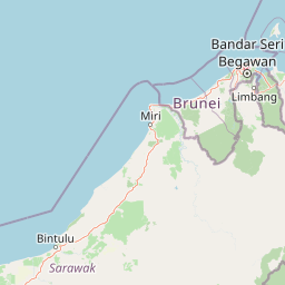
Map view of Loagan Bunut National Park

Use this park location map to pinpoint Loagan Bunut National Park in Malaysia, understand its exact geographic position, and read its mapped placement within the surrounding landscape more clearly.

Pigeon | © OpenStreetMap contributors

Location context for Loagan Bunut National Park

Sarawak
Park atlas

Trace the Regional Spread of National Parks and Protected Wetlands Across Malaysian Borneo

Discover More Protected Areas Near Loagan Bunut National Park: Explore Sarawak's Wetland Landscapes
Browse other national parks and protected areas situated near Loagan Bunut National Park, extending your discovery across Sarawak's unique wetland ecosystems and riparian habitats. Compare the mapped geography of these protected landscapes to understand their regional context and conservation significance within Borneo.
Watercolor illustration of a landscape with green hills, trees, and a valley
National parkSarawak

Niah National Park: Sarawak's Protected National Park Geography and Mapped Landscape

Explore protected area boundaries and regional context within Sarawak

Niah National Park represents a significant protected national park, offering a distinct geographic and landscape identity within Sarawak, Malaysia. This resource facilitates the exploration of its mapped boundaries and its place within the regional atlas of Borneo. Users can delve into the specific geography of this protected area, understanding its landscape characteristics and its contribution to the broader conservation mapping of the region.

Established
1974
Relief
Mountain
Access
Moderate access
Scope
Terrestrial
National parkSarawak

Lambir Hills National Park: Sarawak's National Park Landscape and Geographic Discovery

Explore the mapped terrain and protected boundaries within Sarawak.

Investigate Lambir Hills National Park, a protected national park in Sarawak, Malaysia. This page provides essential geographic context and details its protected landscape identity. Understand its role within the Borneo region's atlas, offering users a deep dive into its mapped terrain and specific regional geography. Discover a key piece of Malaysia's natural protected areas with focused atlas-style information.

Area
69.52 km²
Established
1975
IUCN
II
Relief
Lowland
National parkMarudi District

Gunung Mulu National Park: A Protected National Park with Distinct Geographic Identity in Marudi District

Explore its mapped protected area and regional landscape.

Gunung Mulu National Park stands as a key protected area within Marudi District, Malaysia, offering critical insights into the region's natural geography. This national park entity provides a focal point for understanding mapped protected landscapes and their specific geographic characteristics. Users can explore the park's boundaries and its role within the wider atlas of Malaysian natural areas, gaining a solid foundation in its conservation geography.

Area
528.64 km²
Established
1974
IUCN
II
Relief
Mountain
Nature reserveBrunei

Luagan Lalak Forest Recreation Park Nature Reserve: Brunei's Pristine Freshwater Swamp Landscape

Explore mapped protected-area geography and unique wetland terrain.

Luagan Lalak Forest Recreation Park, a protected nature reserve in Brunei, preserves a rare and visually distinctive freshwater swamp ecosystem. Characterized by dark, tranquil waters and vast fields of purun grass, this natural wetland offers a unique landscape context and is a prime location for observing its rich biodiversity, especially its notable birdlife. The park's preservation as an intact swamp environment within a recreational area highlights its ecological importance for regional geography and protected-area mapping.

Area
2.7 km²
Established
1980
IUCN
II
Visitors
4.2K annual
National parkBintulu Division

Bukit Tiban National Park: National Park Protected Area with Mapped Boundaries

Discover its geographic setting within Bintulu Division.

Bukit Tiban National Park stands as a significant protected natural area, offering a deep dive into its specific geography and mapped landscape. As a national park within Bintulu Division, it provides crucial atlas-level insight into regional protected lands. Explore the precise location and understand its context within Malaysia's network of natural conservation areas.

Area
96 km²
Established
2000
IUCN
II
Relief
Upland
National parkMiri Division

Usun Apau National Park: National Park with Regional Geographic Context in Miri Division

Explore protected boundaries and mapped landscape details.

Usun Apau National Park represents a distinct protected landscape within the Miri Division, identified as a national park. This entry focuses on its geographic attributes, including its mapped boundaries and its contribution to the regional protected area network. Users can explore Usun Apau National Park to understand its specific role in the geography of Miri Division and to gain context on Malaysia's conservation landscapes.

Area
471.22 km²
Established
2005
IUCN
II
Relief
Mountain
National parkSarawak

Gunung Buda National Park: Sarawak National Park Protected Landscape and Geography

Explore the mapped boundaries and regional context of this Malaysian national park.

Gunung Buda National Park is a significant protected area within Sarawak, Malaysia, contributing to the region's diverse geography. As a national park, it offers specific insights into mapped protected lands, providing a focal point for understanding Borneo's natural landscapes. This entry details its geographic identity and its role as a protected natural space, crucial for any atlas-driven exploration of East Malaysia's conservation areas.

Area
66.2 km²
Established
2001
IUCN
II
Relief
Mountain
Protected areaBrunei

Tasek Merimbun Heritage Park: Protected Landscape Identity and Geographic Atlas

Mapped boundaries and regional natural context for this Brunei protected area.

Tasek Merimbun Heritage Park represents a distinct protected area within the geography of Brunei. This page provides detailed insight into its protected landscape, offering a map-centric view of its boundaries and its placement within the broader natural context of Borneo. Understand the park's geographic significance and explore its unique attributes for structured atlas exploration.

Area
78 km²
Established
1984
Climate
Tropical
Access
Easy access

Common questions about visiting, size, designation, and location context for Loagan Bunut National Park

Loagan Bunut National Park FAQs for park facts, access, geography, and protected area context
Find quick answers about Loagan Bunut National Park, including protected-area facts, park geography, trail and visitor context, and how the park fits into its surrounding country and regional landscape.
MoriAtlas Explorer

Continue Your Protected Areas Search Across the Global Atlas

Deepen your exploration by continuing the structured search for national parks and protected areas worldwide. Utilize the comprehensive filtering capabilities to compare different conservation landscapes and refine your understanding of global park geography. Discover more about the distribution and characteristics of protected natural areas.

Global natural geography
Loagan Bunut National Park: Sarawak Protected Area Atlas & Geography
