Mori Atlas logo
National parkUsun Apau National Park

Trace the mapped boundaries and understand the regional park geography of this protected natural area.

Usun Apau National Park: A Protected National Park in Miri Division's Geographic Landscape

(Taman Negara Usun Apau)

Usun Apau National Park stands as a significant protected natural area within the Miri Division of Malaysia, offering a unique lens for geographic exploration and atlas-based discovery. This page details the park's identity as a national park, focusing on its mapped boundaries and its place within the regional landscape context. Understanding Usun Apau National Park provides insight into the distribution of protected lands and the natural terrain that defines this part of the Miri Division.

volcanic plateaumontane rainforestImportant Bird AreaBorneo highlandswaterfallendemic species

Usun Apau National Park

National park

Park overview

Structured park overview, official facts, and landscape profile for Usun Apau National Park

Usun Apau National Park park facts, protected area profile, and essential visitor context
Review the core facts for Usun Apau National Park, including designation, size, terrain, visitor scale, habitats, and operating context in one park-focused overview.

About Usun Apau National Park

Usun Apau National Park occupies a distinctive place among Malaysia's protected areas as a highland sanctuary on the island of Borneo. The park was established in 2005 through the efforts of the Sarawak Forestry Corporation, protecting a volcanic plateau that rises dramatically from the surrounding lowland terrain of central Sarawak. The plateau's formation through ancient volcanic activity has created a unique landscape of craggy peaks, steep escarpments, and fertile volcanic soils that support specialized vegetation communities. The park's significance extends beyond its borders as the headwaters for both the Rajang and Baram rivers, two of Borneo's most important river systems that sustain communities and ecosystems throughout the region. Access remains challenging, with visitors arriving via logging roads to the plateau's base before continuing on foot along maintained trails. The relative remoteness of Usun Apau has contributed to its ecological integrity, preserving habitats that have remained largely undisturbed by development or intensive tourism.

Quick facts and research context for Usun Apau National Park

Usun Apau National Park spans 471.22 square kilometers in the Miri Division of Sarawak, Malaysia, on the island of Borneo. The park was officially designated in 2005 and protects the Usun Apau volcanic plateau, which averages 1,000 meters in elevation. Three extinct volcanoes punctuate the plateau: Selidang (1,370 m), Kenawing (1,280 m), and Mabun (1,280 m). The Julan waterfall, standing approximately 245 meters high, is the park's most notable waterfall and drains from rivers originating on the plateau. The area is recognized as an Important Bird Area due to its population of vulnerable and near-threatened bird species.

Park context

Deeper park guide and search-rich context for Usun Apau National Park

Usun Apau National Park history, landscape, wildlife, and travel context
Explore Usun Apau National Park through its history, landscape character, ecosystems, wildlife, conservation priorities, cultural context, and seasonal travel timing in a structured park guide built for atlas discovery and search intent.

Why Usun Apau National Park stands out

Usun Apau National Park is best known for its dramatic volcanic plateau landscape and the spectacular Julan waterfall, one of Borneo's highest waterfalls at nearly 245 meters. The park protects a distinctive montane rainforest ecosystem that includes unique kerapa forest, characterized by stunted trees with gnarled trunks growing on poorly drained, nutrient-poor soils, and kerangas forest on infertile volcanic soils. The plateau serves as a critical biodiversity hotspot, supporting multiple vulnerable and near-threatened bird species including Bulwer's pheasant, the Bornean ground cuckoo, and the rhinoceros hornbill. The park's relative inaccessibility has helped preserve its natural character, making it a destination for those seeking untouched highland environments.

Usun Apau National Park history and protected-area timeline

Usun Apau National Park was officially designated in 2005, becoming part of Sarawak's network of protected areas managed by the Sarawak Forestry Corporation. The establishment of the park provided formal protection to the Usun Apau plateau, which had previously lacked protected status despite its ecological significance. The region's volcanic history dates to ancient geological periods, with the three extinct volcanoes of Selidang, Kenawing, and Mabun serving as testament to the plateau's origins. In August 2022, Sarawak's premier announced plans to improve road access to the national park, specifically highlighting Julan Waterfall as a target for tourism development under the state's Post-COVID-19 Development Strategy extending through 2030. This development initiative represents the most recent chapter in the park's history and signals potential changes to visitor accessibility in the coming years.

Usun Apau National Park landscape and geographic character

The Usun Apau plateau presents a dramatic highland landscape shaped by ancient volcanic activity. The plateau covers approximately 1,550 square kilometers and averages 1,000 meters in elevation, rising prominently above the surrounding lowland terrain of central Borneo. Three extinct volcanoes mark the center of the plateau: Selidang reaches 1,370 meters, while Kenawing and Mabun both stand at approximately 1,280 meters above sea level. The plateau's edges terminate in steep escarpments that drop nearly 300 meters vertically, creating dramatic cliffs visible from the surrounding lowlands. The Julan River originates on the plateau and plummets over the edge of the northern escarpment to form the Julan waterfall, a cascading torrent of approximately 245 meters that ranks among Borneo's tallest waterfalls. Numerous streams descending from the plateau contribute to the headwaters of both the Rajang and Baram river systems, making this highland area a critical hydrological node for the entire region.

Usun Apau National Park ecosystems, habitats, and plant life

The ecological character of Usun Apau National Park is defined by its montane rainforest ecosystems, which differ substantially from the lowland rainforests that dominate much of Borneo. The plateau supports several distinct vegetation types adapted to the cooler temperatures and unique soil conditions of the highland environment. The kerapa forest represents a specialized community of stunted trees with gnarled trunks, adapted to thrive in areas of poor soil drainage and low nutrient availability. The kerangas forest occupies areas with more fertile volcanic soils, featuring taller trees with relatively thin trunks that have developed on the nutrient-rich substrates resulting from ancient volcanic activity. The lower slopes of the plateau support hill dipterocarp forest, connecting the montane environment to the broader lowland rainforest ecosystem. This mosaic of habitat types creates ecological diversity within a relatively compact area, supporting both species adapted to highland conditions and those that range across elevation gradients.

Usun Apau National Park wildlife and species highlights

Usun Apau National Park supports a notable collection of bird species, several of which carry conservation designations due to their limited distributions or declining populations. The plateau has been recognized as an Important Bird Area, highlighting its significance for avian conservation in Borneo. Among the vulnerable species found here is Bulwer's pheasant, a distinctive ground-dwelling bird with striking plumage. The Bornean ground cuckoo represents another rare sighting for patient observers. The rhinoceros hornbill, with its impressivecasqued beak, frequents the forest canopy. Other notable species include the ferruginous partridge, the Dulit frogmouth and Gould's frogmouth (both nightjars with cryptic camouflage), Whitehead's trogon, Hose's broadbill, the black oriole, the Sunda laughingthrush, and Everett's thrush. Beyond birds, the park harbors the gracile slender toad, a species known only from the Usun Apau plateau and one additional locality, making it particularly significant for amphibian conservation.

Usun Apau National Park conservation status and protection priorities

The designation of Usun Apau as a national park in 2005 provided formal protection for a volcanic plateau ecosystem that had previously lacked dedicated conservation status. The park's recognition as an Important Bird Area underscores its international significance for biodiversity conservation, particularly for the collection of vulnerable and near-threatened species that depend on montane rainforest habitats. The isolated nature of the plateau has historically limited human impact, preserving ecological integrity despite surrounding lowland deforestation. The park's role as a watershed for the Rajang and Baram rivers extends its conservation importance beyond its borders, as these river systems support downstream ecosystems and communities. Management by the Sarawak Forestry Corporation provides institutional capacity for protection and monitoring, though the park's remote location presents challenges for enforcement and visitor management.

Usun Apau National Park cultural meaning and human context

Usun Apau National Park is situated within the traditional lands of indigenous communities in central Sarawak. The highland plateau and its resources have long been part of the cultural landscape for local Dayak peoples, who have maintained connections to these lands through traditional land use and resource management practices. The park's relative inaccessibility has limited widespread human settlement on the plateau itself, preserving both ecological values and cultural associations with the landscape. While the park does not contain extensively documented archaeological sites or monuments, the natural features of Usun Apau—including the waterfalls and volcanic formations—hold cultural significance for local communities. The announcement of improved access roads in 2022 represents a new phase in the park's relationship with surrounding communities and may bring both tourism opportunities and management challenges.

Top sights and standout views in Usun Apau National Park

The Julan waterfall, dropping approximately 245 meters in a single cascade, stands as the park's most spectacular natural feature and ranks among Borneo's highest waterfalls. The volcanic plateau landscape, with its three extinct volcanoes and dramatic 300-meter escarpments, offers trekking opportunities through terrain unlike the more common lowland rainforests of the region. The montane forest ecosystems, including the distinctive kerapa and kerangas forests, provide habitat for species found nowhere else on Earth. The relative remoteness of Usun Apau, while a barrier to casual tourism, has preserved a sense of wilderness that distinguishes it from more accessible protected areas.

Best time to visit Usun Apau National Park

The best time to visit Usun Apau National Park aligns with the broader dry season in Sarawak, typically from March through October, when rainfall is reduced and trail conditions are more favorable for trekking. The montane environment experiences cooler temperatures than the surrounding lowlands, providing a more comfortable climate for physical activity. However, visitors should be prepared for weather variability even during optimal seasons, as mountain environments can generate fog, mist, and afternoon showers regardless of the period. The wet season from November through February brings higher precipitation, which can make trails more challenging and access roads more difficult to navigate. Given the park's limited infrastructure and remote location, visitors should plan ahead and be prepared for basic facilities upon arrival.

Park location guide

Geography guide, regional context, and park location map for Usun Apau National Park

Usun Apau National Park park geography, regions, and map view in Malaysia
Understand where Usun Apau National Park sits in Malaysia through a broader geographic reading of the surrounding landscape, nearby location context, and its mapped position within the national park landscape.

How Usun Apau National Park fits into Malaysia

Malaysia is a federal constitutional monarchy located in Southeast Asia. The country consists of 13 states and three federal territories, divided by the South China Sea into Peninsular Malaysia on the Indochinese Peninsula and East Malaysia on the island of Borneo. With a population of over 34 million, it achieved independence from Britain in 1957 and became a modern federation in 1963. The country is recognized for its multicultural population, tropical climate, and significant economic role in the region.

Wider geography shaping Usun Apau National Park in Malaysia

Malaysia occupies a strategic position in Southeast Asia, split by the South China Sea into two distinct regions. Peninsular Malaysia lies on the Indochinese Peninsula, sharing a land border with Thailand to the north and maritime borders with Singapore, Vietnam, and Indonesia. East Malaysia occupies the northern portion of Borneo, sharing land borders with Brunei and Indonesia, and maritime borders with the Philippines and Vietnam. The country's terrain includes coastal plains, mountain ranges such as the Titiwangsa in the peninsula, and extensive tropical rainforests.

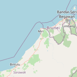
Map view of Usun Apau National Park

Use this park location map to pinpoint Usun Apau National Park in Malaysia, understand its exact geographic position, and read its mapped placement within the surrounding landscape more clearly.

Pigeon | © OpenStreetMap contributors

Location context for Usun Apau National Park

Miri DivisionSarawak
Park atlas

Map connected protected landscapes and compare parks within Borneo's distinct highland geography, tracing the regional park spread.

Explore Nearby Protected Areas and Regional Parks Around Usun Apau National Park
After exploring Usun Apau National Park's unique volcanic plateau and montane ecosystems, browse a curated selection of other protected areas, tracing the broader park geography of central Sarawak. Compare adjacent protected landscapes across the Borneo highlands and understand their distinct conservation profiles, from critical watersheds to diverse rainforest reserves.
National parkSarawak

Loagan Bunut National Park: Protected Landscape in Sarawak, Malaysia

Explore the mapped geography and natural terrain of this national park.

This page offers a detailed atlas-style exploration of Loagan Bunut National Park, situated in Sarawak, Malaysia. Understand the park's designation as a national park and its place within the mapped geography of Borneo. It provides essential context for appreciating the protected landscape and its regional significance.

Area
100 km²
Established
1990
IUCN
II
Scope
Terrestrial
National parkNorth Kalimantan

Kayan Mentarang National Park: A Protected Landscape in North Kalimantan

Explore Borneo's critical protected area and its vast forest geography.

Kayan Mentarang National Park is an immense protected area in North Kalimantan, Indonesia, renowned for being a crucial part of the Heart of Borneo conservation initiative. This national park encompasses over 13,600 square kilometers of primary tropical rainforest, sheltering diverse montane and lowland habitats along the Indonesia-Malaysia border. Its importance lies in its vast, contiguous landscape, critical role in regional biodiversity, and its representation of one of Southeast Asia's last great wilderness expanses, offering significant insight into mapped protected areas.

Area
13,605 km²
Established
1996
IUCN
II
Scope
Mixed
National parkLimbang Division

Pulong Tau National Park: A Protected National Park in Malaysia's Limbang Division

Explore its mapped boundaries and regional landscape context.

Pulong Tau National Park represents a key protected area within the Limbang Division, offering valuable geographic and atlas-based discovery opportunities. This page details the park's identity as a national park, focusing on its mapped boundaries and its role within the protected landscapes of Malaysia. Users can explore the park's specific geographic characteristics and understand its context within the regional atlas, providing a factual foundation for appreciating its natural landscape value.

Area
665.25 km²
Established
1998
IUCN
II
Relief
Mountain
National parkMarudi District

Gunung Mulu National Park: A Protected National Park with Distinct Geographic Identity in Marudi District

Explore its mapped protected area and regional landscape.

Gunung Mulu National Park stands as a key protected area within Marudi District, Malaysia, offering critical insights into the region's natural geography. This national park entity provides a focal point for understanding mapped protected landscapes and their specific geographic characteristics. Users can explore the park's boundaries and its role within the wider atlas of Malaysian natural areas, gaining a solid foundation in its conservation geography.

Area
528.64 km²
Established
1974
IUCN
II
Relief
Mountain
Watercolor illustration of a landscape with green hills, trees, and a valley
National parkSarawak

Niah National Park: Sarawak's Protected National Park Geography and Mapped Landscape

Explore protected area boundaries and regional context within Sarawak

Niah National Park represents a significant protected national park, offering a distinct geographic and landscape identity within Sarawak, Malaysia. This resource facilitates the exploration of its mapped boundaries and its place within the regional atlas of Borneo. Users can delve into the specific geography of this protected area, understanding its landscape characteristics and its contribution to the broader conservation mapping of the region.

Established
1974
Relief
Mountain
Access
Moderate access
Scope
Terrestrial
National parkBintulu Division

Bukit Tiban National Park: National Park Protected Area with Mapped Boundaries

Discover its geographic setting within Bintulu Division.

Bukit Tiban National Park stands as a significant protected natural area, offering a deep dive into its specific geography and mapped landscape. As a national park within Bintulu Division, it provides crucial atlas-level insight into regional protected lands. Explore the precise location and understand its context within Malaysia's network of natural conservation areas.

Area
96 km²
Established
2000
IUCN
II
Relief
Upland
National parkSarawak

Gunung Buda National Park: Sarawak National Park Protected Landscape and Geography

Explore the mapped boundaries and regional context of this Malaysian national park.

Gunung Buda National Park is a significant protected area within Sarawak, Malaysia, contributing to the region's diverse geography. As a national park, it offers specific insights into mapped protected lands, providing a focal point for understanding Borneo's natural landscapes. This entry details its geographic identity and its role as a protected natural space, crucial for any atlas-driven exploration of East Malaysia's conservation areas.

Area
66.2 km²
Established
2001
IUCN
II
Relief
Mountain
National parkSarawak

Lambir Hills National Park: Sarawak's National Park Landscape and Geographic Discovery

Explore the mapped terrain and protected boundaries within Sarawak.

Investigate Lambir Hills National Park, a protected national park in Sarawak, Malaysia. This page provides essential geographic context and details its protected landscape identity. Understand its role within the Borneo region's atlas, offering users a deep dive into its mapped terrain and specific regional geography. Discover a key piece of Malaysia's natural protected areas with focused atlas-style information.

Area
69.52 km²
Established
1975
IUCN
II
Relief
Lowland

Common questions about visiting, size, designation, and location context for Usun Apau National Park

Usun Apau National Park FAQs for park facts, access, geography, and protected area context
Find quick answers about Usun Apau National Park, including protected-area facts, park geography, trail and visitor context, and how the park fits into its surrounding country and regional landscape.
MoriAtlas Explorer

Continue Your Protected Areas Search Across the Global Atlas

Deepen your exploration by continuing the structured search for national parks and protected areas worldwide. Utilize the comprehensive filtering capabilities to compare different conservation landscapes and refine your understanding of global park geography. Discover more about the distribution and characteristics of protected natural areas.

Global natural geography