

Mori Atlas logo
National parkPulong Tau National Park

Atlas exploration of its mapped boundaries and regional park geography.

Pulong Tau National Park: Protected Landscape Identity and Geographic Context in Limbang Division

(Taman Negara Pulong Tau)

Pulong Tau National Park stands as a significant protected area within the Limbang Division of Malaysia. This national park offers critical insight into the region's protected landscape character and geographic distribution. Understanding its mapped boundaries and place within the broader atlas of natural areas is essential for appreciating its conservation context and regional ecological significance. MoriAtlas provides structured data to explore the park's unique geographic footprint and its contribution to the mapped natural terrain of Malaysia.

national parkprotected areaBorneoKelabit Highlandsmontane forestendemic wildlife

Pulong Tau National Park

National park

Park overview

Structured park overview, official facts, and landscape profile for Pulong Tau National Park

Pulong Tau National Park park facts, protected area profile, and essential visitor context
Review the core facts for Pulong Tau National Park, including designation, size, terrain, visitor scale, habitats, and operating context in one park-focused overview.

About Pulong Tau National Park

Pulong Tau National Park represents one of Sarawak's most significant conservation achievements, born from the vision of local indigenous communities who recognized the ecological and cultural value of their highland forests. The park sits in the Kelabit Highlands, a mountainous region in northeastern Borneo that has remained relatively isolated from lowland development pressures. The area's geological history dates to the rifting of the continental crust that preceded Borneo's separation from the Eurasian Plate, leaving behind distinctive limestone and evaporite formations. The park's establishment was a lengthy process that began with community initiatives in the 1970s, leading to formal proposals in 1984 and eventual approval. Notably, the final boundary was reduced from the originally proposed 164,500 hectares to approximately 60,000 hectares due to land development conflicts. Today, the Sarawak Forestry Corporation manages the park, balancing conservation objectives with the traditional relationships that indigenous communities maintain with this landscape. Visitors to Pulong Tau encounter a remarkable transition through forest types as they ascend from the lower dipterocarp zones through oak-laurel forests into the stunted, moss-draped vegetation of the highest peaks.

Quick facts and research context for Pulong Tau National Park

Pulong Tau National Park occupies the Kelabit Highlands in northeastern Sarawak, protecting an area of approximately 665 square kilometers. The park was established following decades of advocacy from local communities beginning in the 1970s, with formal establishment in 1998 and final gazettment in 2005. The landscape is characterized by mountainous terrain formed from rifted continental crust, featuring limestone, sandstone, and mudstone formations. The Tama Abu mountain range runs through the park, with Mount Murud, Sarawak's highest peak, forming a dramatic northern boundary. The park serves as a vital watershed, collecting water for the Baram, Belait, Limbang, Tutong, Trusan, and Padas river systems.

Park context

Deeper park guide and search-rich context for Pulong Tau National Park

Pulong Tau National Park history, landscape, wildlife, and travel context
Explore Pulong Tau National Park through its history, landscape character, ecosystems, wildlife, conservation priorities, cultural context, and seasonal travel timing in a structured park guide built for atlas discovery and search intent.

Why Pulong Tau National Park stands out

Pulong Tau is best known for protecting the extraordinary biodiversity of the Kelabit Highlands, a remote montane region with multiple distinct forest types ranging from upper mixed dipterocarp forests at lower elevations to mossy elfin forests near the peaks. The park is celebrated for its significant endemic wildlife, including 13 species of birds found nowhere else on Earth, 12 endemic mammal species, and numerous unique amphibians and insects. The discovery of a previously thought-extinct population of eastern Sumatran rhinoceros in the area during the 1980s highlighted the park's global conservation importance. The iconic twin peaks of Bukit Batu Lawi and the imposing Mount Murud provide dramatic backdrops to this protected landscape.

Pulong Tau National Park history and protected-area timeline

The creation of Pulong Tau National Park spans more than two decades of community advocacy and governmental negotiation. Indigenous communities in the Kelabit Highlands initiated the concept of protecting this area as early as the 1970s, recognizing both the cultural significance and ecological value of their ancestral lands. In 1984, Sarawak's National Parks and Wildlife Office submitted a formal proposal to the state government, accompanied by a petition letter signed by local community members. The original proposal called for a 164,500-hectare protected area that would encompass Mount Sarawak's highest peak (Mount Murud), the twin summits of Bukit Batu Lawi, the Tama Abu mountain range, and the critical water catchment areas of northern Sarawak. Between 1984 and 1987, the Sarawak cabinet approved the concept but required boundary adjustments to resolve conflicts with areas allocated for commercial land development. A pivotal moment occurred in 1986 when biological surveys discovered a population of eastern Sumatran rhinoceros, a species previously believed to be extinct in Sarawak. The surveys also revealed the ecological significance of the laurel forests for endemic species like the Bornean bearded pig, and documented the presence of Rafflesia flowers at Mount Murud's base and occasional orangutan sightings. These findings prompted a second proposal in 1987 arguing for expanded protection. By 1998, when the proclamation creating the park was finally passed, the designated area had been reduced to 63,700 hectares, excluding both Batu Lawi and the rhinoceros habitat. The park was formally gazetted in 2005 with a protected area of 59,917 hectares.

Pulong Tau National Park landscape and geographic character

The Pulong Tau landscape is defined by the dramatic topography of the Kelabit Highlands, a mountainous region shaped by ancient geological processes. The area formed from rifted continental crust where water-borne sediments were deposited before Borneo's separation from the Eurasian Plate, a history evidenced by the presence of evaporite deposits and limestone formations. The terrain displays clear evidence of geological folding and faulting along a northeast-southwest axis, creating the folded ridges and valley systems visible today. The park encompasses several distinct geological zones: oxidized iron and coal-bearing sandstones dominate the eastern portions of the Kelabit Highlands, while mudstone and limestone characterize the central highland areas, giving way to grey sandstones in the Mount Murud region to the west. The Tama Abu mountain range traverses the southern portion of the park, while Mount Murud rises as the highest peak in Sarawak, forming an imposing northern landmark. The park protects critical watershed areas, serving as the water catchment for the Baram, Belait, Limbang, Tutong, Trusan, and Padas rivers that sustain communities throughout northern Sarawak.

Pulong Tau National Park ecosystems, habitats, and plant life

The ecological diversity of Pulong Tau National Park reflects the complex interplay of altitude, soil type, and topography across the Kelabit Highlands. The park contains a succession of forest types that transition with increasing elevation: upper mixed dipterocarp forest dominates the lower slopes, transitioning into oak-laurel forest, then into heath forest (kerangas) on the more impoverished soils, and finally into mossy elfin forest near the highest summits. These vegetation zones are not sharply delineated but overlap considerably, creating complex habitat mosaics. The mossy elfin forest is particularly rich in Rhododendron species, with the epiphytic orchids and Nepenthes pitcher plants found throughout adding to the botanical richness. The 1998 biological expedition documented 67 bird species across 29 families, with 19.4 percent being endemic to Borneo. Notable findings included Mountain Imperial Pigeons, Chestnut Crested Yuhina, and Blacknest Swifelet, while the highest peaks of Mount Murud and Batu Lawi supported species such as the Ochraceous Bulbul and Mountain Blackeye. The park also supports 28 mammal species, 12 of which are endemic to Borneo, including the unusual Mountain Giant Rat and Summit Rat.

Pulong Tau National Park wildlife and species highlights

Pulong Tau harbors remarkable wildlife diversity despite its relatively compact size, with the montane environment supporting numerous species found nowhere else on Earth. The mammal fauna includes 28 documented species, of which 12 are endemic to Borneo. Notable among these are the Mountain Giant Rat (Sundamys infraluteus) and the Summit Rat (Rattus baluensis), both specialized inhabitants of highland forest habitats. Civets and other carnivores also occur within the park boundaries. The avifauna is equally impressive, with 67 species recorded from 29 families during the 1998 survey, including 13 endemic species representing nearly 20 percent of the total bird count. The amphibian fauna includes 18 species of frogs, while four snake species have been documented, among them the Wagler's Pit Viper. Insects are exceptionally diverse, with trilobite beetles (Platerodrilus), fruit flies (Drosophila), and numerous weevil species recorded. The park also provides occasional habitat for orangutans, while the discovery of an eastern Sumatran rhinoceros population nearby during the 1980s highlighted the region's significance for one of the world's most endangered large mammals.

Pulong Tau National Park conservation status and protection priorities

Pulong Tau National Park represents a critical conservation area within Borneo, protecting montane habitats that are poorly represented in the protected area network. The park's establishment was driven by recognition of its exceptional biodiversity, particularly the presence of endangered species including the eastern Sumatran rhinoceros. Although the final boundaries exclude the confirmed rhino habitat, the park still protects substantial areas of ecologically significant forest. The various forest types, from dipterocarp lowland forest through oak-laurel forest to mossy elfin summit vegetation, represent a complete altitudinal gradient that supports diverse ecological communities. The park's role as a water catchment area for six major river systems adds an essential ecosystem service dimension to its conservation value, sustaining water supplies for downstream communities across northern Sarawak. The Sarawak Forestry Corporation maintains management responsibility, working to balance protection objectives with the traditional land-use practices of indigenous communities whose cultural identity is intimately connected to these forests.

Pulong Tau National Park cultural meaning and human context

The cultural landscape of Pulong Tau is inseparable from the indigenous communities of the Kelabit Highlands, particularly the Kelabit and Lun Bawang peoples. The very name Pulong Tau carries profound cultural meaning, translating as 'our forests' in both Lun Bawang and Kelabit dialects. This name encapsulates the deep pride that indigenous people hold for their forest heritage and their ancestral lands. The park's establishment was fundamentally a community-driven initiative, with local communities advocating for protection of their traditional territories beginning in the 1970s. Their petition in 1984 was instrumental in launching the formal process that eventually led to the park's creation. The relationship between these communities and the landscape extends beyond practical land use to encompass spiritual and cultural dimensions that are reflected in place names, traditional practices, and collective memory. The park's management continues to involve these communities, recognizing that effective conservation in this remote highland region depends on respecting indigenous rights and traditional ecological knowledge.

Top sights and standout views in Pulong Tau National Park

Pulong Tau National Park offers visitors access to some of Borneo's most spectacular highland environments, anchored by Mount Murud, the highest peak in Sarawak. The twin summits of Bukit Batu Lawi create an iconic silhouette visible from much of the surrounding highlands. The transition through multiple forest types provides exceptional opportunities for observing botanical diversity, from the massive dipterocarp trees of the lower slopes to the miniature Rhododendron gardens of the mossy elfin forest. Bird enthusiasts will find significant populations of endemic species, particularly in the higher elevation zones. The park's role as a watershed for six major river systems underscores its importance beyond biodiversity, serving communities throughout northern Sarawak. The cultural heritage of the Kelabit and Lun Bawang peoples is woven throughout the landscape, making any visit an encounter with living indigenous culture as much as natural history.

Best time to visit Pulong Tau National Park

The Kelabit Highlands experience a tropical montane climate that differs substantially from the hot lowlands of Borneo. The optimal period for visiting Pulong Tau typically falls during the drier months from March to September, when conditions are more favorable for hiking and wildlife observation. The northeast monsoon season from November to February brings higher rainfall to the region, though the montane forests remain lush year-round. Temperature decreases with elevation, and visitors should prepare for cool conditions especially at higher altitudes where mist and clouds are common. The wet season can bring reduced visibility on mountain peaks but also reveals the forests at their most verdant, with waterfalls at their fullest and cascades flowing through the valleys. Regardless of season, the remote nature of the park requires careful planning, and access is typically arranged through the Sarawak Forestry Corporation or authorized tour operators familiar with the region.

Park location guide

Geography guide, regional context, and park location map for Pulong Tau National Park

Pulong Tau National Park park geography, regions, and map view in Malaysia
Understand where Pulong Tau National Park sits in Malaysia through a broader geographic reading of the surrounding landscape, nearby location context, and its mapped position within the national park landscape.

How Pulong Tau National Park fits into Malaysia

Malaysia is a federal constitutional monarchy located in Southeast Asia. The country consists of 13 states and three federal territories, divided by the South China Sea into Peninsular Malaysia on the Indochinese Peninsula and East Malaysia on the island of Borneo. With a population of over 34 million, it achieved independence from Britain in 1957 and became a modern federation in 1963. The country is recognized for its multicultural population, tropical climate, and significant economic role in the region.

Wider geography shaping Pulong Tau National Park in Malaysia

Malaysia occupies a strategic position in Southeast Asia, split by the South China Sea into two distinct regions. Peninsular Malaysia lies on the Indochinese Peninsula, sharing a land border with Thailand to the north and maritime borders with Singapore, Vietnam, and Indonesia. East Malaysia occupies the northern portion of Borneo, sharing land borders with Brunei and Indonesia, and maritime borders with the Philippines and Vietnam. The country's terrain includes coastal plains, mountain ranges such as the Titiwangsa in the peninsula, and extensive tropical rainforests.

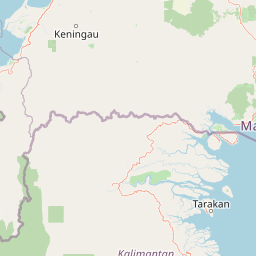
Map view of Pulong Tau National Park

Use this park location map to pinpoint Pulong Tau National Park in Malaysia, understand its exact geographic position, and read its mapped placement within the surrounding landscape more clearly.

Pigeon | © OpenStreetMap contributors

Location context for Pulong Tau National Park

Limbang DivisionSarawak
Park atlas

Trace connected protected areas across Borneo's Kelabit Highlands and surrounding montane terrain for regional comparison

Discover Other National Parks and Protected Landscapes Near Pulong Tau National Park
Explore a curated list of national parks and other protected areas located near Pulong Tau National Park, tracing their geographic spread across Borneo's Kelabit Highlands and surrounding montane terrain. Use this regional context to compare unique ecological features, understand conservation values, and discover the broader network of protected landscapes.
National parkNorth Kalimantan

Kayan Mentarang National Park: A Protected Landscape in North Kalimantan

Explore Borneo's critical protected area and its vast forest geography.

Kayan Mentarang National Park is an immense protected area in North Kalimantan, Indonesia, renowned for being a crucial part of the Heart of Borneo conservation initiative. This national park encompasses over 13,600 square kilometers of primary tropical rainforest, sheltering diverse montane and lowland habitats along the Indonesia-Malaysia border. Its importance lies in its vast, contiguous landscape, critical role in regional biodiversity, and its representation of one of Southeast Asia's last great wilderness expanses, offering significant insight into mapped protected areas.

Area
13,605 km²
Established
1996
IUCN
II
Scope
Mixed
National parkMarudi District

Gunung Mulu National Park: A Protected National Park with Distinct Geographic Identity in Marudi District

Explore its mapped protected area and regional landscape.

Gunung Mulu National Park stands as a key protected area within Marudi District, Malaysia, offering critical insights into the region's natural geography. This national park entity provides a focal point for understanding mapped protected landscapes and their specific geographic characteristics. Users can explore the park's boundaries and its role within the wider atlas of Malaysian natural areas, gaining a solid foundation in its conservation geography.

Area
528.64 km²
Established
1974
IUCN
II
Relief
Mountain
National parkSarawak

Gunung Buda National Park: Sarawak National Park Protected Landscape and Geography

Explore the mapped boundaries and regional context of this Malaysian national park.

Gunung Buda National Park is a significant protected area within Sarawak, Malaysia, contributing to the region's diverse geography. As a national park, it offers specific insights into mapped protected lands, providing a focal point for understanding Borneo's natural landscapes. This entry details its geographic identity and its role as a protected natural space, crucial for any atlas-driven exploration of East Malaysia's conservation areas.

Area
66.2 km²
Established
2001
IUCN
II
Relief
Mountain
National parkMiri Division

Usun Apau National Park: National Park with Regional Geographic Context in Miri Division

Explore protected boundaries and mapped landscape details.

Usun Apau National Park represents a distinct protected landscape within the Miri Division, identified as a national park. This entry focuses on its geographic attributes, including its mapped boundaries and its contribution to the regional protected area network. Users can explore Usun Apau National Park to understand its specific role in the geography of Miri Division and to gain context on Malaysia's conservation landscapes.

Area
471.22 km²
Established
2005
IUCN
II
Relief
Mountain
National parkBrunei

Ulu Temburong National Park: Brunei's Protected Rainforest Landscape and Geographic Context

Mapped natural terrain and conservation significance.

Ulu Temburong National Park represents Brunei's commitment to preserving its most ecologically significant tropical rainforests, covering approximately 550 square kilometers. This protected area is characterized by its remote location in the Temburong District and its diverse topography, ranging from lowland areas to mountainous ridges, all within a largely undisturbed natural setting. The park's mapped boundaries encompass a vital transboundary conservation landscape, making it a key site for understanding Borneo's unique ecosystems and forest protection policies through an atlas-driven exploration approach.

Area
488.59 km²
Established
1991
IUCN
II
Relief
Mixed relief
National parkSarawak

Loagan Bunut National Park: Protected Landscape in Sarawak, Malaysia

Explore the mapped geography and natural terrain of this national park.

This page offers a detailed atlas-style exploration of Loagan Bunut National Park, situated in Sarawak, Malaysia. Understand the park's designation as a national park and its place within the mapped geography of Borneo. It provides essential context for appreciating the protected landscape and its regional significance.

Area
100 km²
Established
1990
IUCN
II
Scope
Terrestrial
Nature reserveTemburong District

Peradayan Forest Reserve Nature Reserve: Understanding its Protected Landscape and Geographic Setting

Explore mapped boundaries and the natural terrain of this Brunei reserve.

Peradayan Forest Reserve stands as a significant protected natural area within Brunei's Temburong District, an exclave characterized by vast tropical rainforests. This entry focuses on its identity as a nature reserve, providing key geographic context and details about its mapped boundaries. Understand its role within the regional landscape and how its protected status contributes to the conservation of Brunei's natural heritage, facilitating a deeper dive into atlas-style geographic exploration.

Area
26.5 km²
Relief
Upland
Climate
Tropical
Access
Moderate access
Protected areaBrunei

Tasek Merimbun Heritage Park: Protected Landscape Identity and Geographic Atlas

Mapped boundaries and regional natural context for this Brunei protected area.

Tasek Merimbun Heritage Park represents a distinct protected area within the geography of Brunei. This page provides detailed insight into its protected landscape, offering a map-centric view of its boundaries and its placement within the broader natural context of Borneo. Understand the park's geographic significance and explore its unique attributes for structured atlas exploration.

Area
78 km²
Established
1984
Climate
Tropical
Access
Easy access

Common questions about visiting, size, designation, and location context for Pulong Tau National Park

Pulong Tau National Park FAQs for park facts, access, geography, and protected area context
Find quick answers about Pulong Tau National Park, including protected-area facts, park geography, trail and visitor context, and how the park fits into its surrounding country and regional landscape.
MoriAtlas Explorer

Continue Your Protected Areas Search Across the Global Atlas

Deepen your exploration by continuing the structured search for national parks and protected areas worldwide. Utilize the comprehensive filtering capabilities to compare different conservation landscapes and refine your understanding of global park geography. Discover more about the distribution and characteristics of protected natural areas.

Global natural geography
