
Streams
Park geography
Examining the physical landscape, river systems, and protected area dimensions
Comprehensive Geographic Profile and Mapped Boundaries of Lower Glenelg National Park in Australia
This geographic profile details the physical characteristics of Lower Glenelg National Park, which covers a recorded area of 273 square kilometers in Australia. Analysis includes the spatial extent of the park, major riverine features such as the Glenelg River, and the distribution of natural landmarks like Moleside Falls and the Princess Margaret Rose Cave.
Related tags
Gorge landscapesLimestone cavesRiver ecosystemsWetland habitatsBushwalking trails
Gorge landscape and ancient cave system in Victoria's Western District
Lower Glenelg National Park
Lower Glenelg National Park is a protected area in the Western District of Victoria, Australia, situated approximately 323 kilometres west of Melbourne. The park encompasses 27,300 hectares of diverse landscape centred on the dramatic Glenelg River gorge, which has been carved over millions of years through limestone and sandstone terrain. Established in 1969, the park protects a significant stretch of the river as it flows from its upper catchment toward the Southern Ocean, preserving both the gorge's steep cliff walls and the surrounding woodlands and wetlands. The park is distinguished by the presence of Princess Margaret Rose Cave, an accessible limestone cavern showcasing impressive stalactite and stalagmite formations that have developed over an estimated 800,000 years. Above ground, the park features a network of walking tracks, including a substantial portion of the Great South West Walk, a long-distance trail that showcases the region's varied terrain. The park forms part of a larger cross-border conservation network, bordering Cobboboonee National Park to the east and linking with protected areas in South Australia to the west, creating an important corridor for biodiversity across the Victoria-South Australia border region. The park was designated as a Ramsar site in 2018, recognising the international significance of the Glenelg Estuary and Discovery Bay wetland system that extends beyond the park's boundaries. This recognition underscores the ecological importance of the coastal wetlands and estuary habitats that support diverse waterbird communities and migratory species.
- Location
- Australia
- Park type
- National park
- Established
- 1969
- Area
- 273 km²
Location overview
National location data and regional placement within Australia
Lower Glenelg National Park Geography and Location in Australia
Lower Glenelg National Park is a protected natural reserve situated within the country of Australia. Natural area records confirm its localized administrative placement along with its single-country status.
- Countries
- Australia
- Primary location
- Australia
Boundary and coordinates
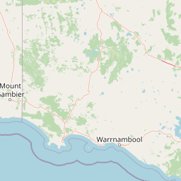
Lower Glenelg’s mapped boundary frames a 273 km² extent
Lower Glenelg National Park mapped boundary and 273 km² area
Lower Glenelg National Park is shown with geometry covering a recorded 273 km². This atlas representation communicates the park’s spatial reach while remaining distinct from official boundary-survey records.
- Boundary area
- 264.5 km²
- Boundary perimeter
- 161.3 km
- Northernmost point
- 37.9837° S
- Southernmost point
- 38.1677° S
- Easternmost point
- 141.4111° E
- Westernmost point
- 140.9667° E
- Geographic centre
- 38.058° S, 141.2329° E
- North–south span
- 20.4 km
- East–west span
- 39 km
Terrain and natural features
Mixed relief classifications and recorded hydrographic features
Lower Glenelg National Park Terrain and Named Natural Features
Lower Glenelg National Park contains mixed terrain relief and multiple recorded natural features including the Glenelg River and Princess Margaret Rose Cave. Individual feature cards detail types and spatial relationships across the protected area.
Selected named natural features
Streams
Gallows Creek
Peaks
One Tree Hill
Viewpoints
River lookout
Streams
Little Moleside Creek
Reservoirs
The Inkpot
Environmental setting
Temperate climate zones, mixed relief, and partial forest cover records
Lower Glenelg National Park Environmental Classifications and Physical Setting
Recorded landscape features, habitat types, and climate categories provide structured insight into the physical setting of Lower Glenelg National Park. Stored classifications connect recorded environmental properties to corresponding atlas destinations.
- Relief
- Mixed relief
- Climate
- Temperate
- Water
- Minor water
- Forest cover
- Partial forest
Landscape features
Valleys · Rivers · Cave · Wetland
Habitat types
Riverine habitat · Coastal habitat · Wetland
Park atlas
Compare the diverse protected landscapes, river systems, and coastal wetlands in the regional context of Lower Glenelg National Park.
National Parks and Protected Areas: Explore Beyond Lower Glenelg National Park
After exploring Lower Glenelg National Park, browse surrounding national parks and protected areas, mapping the regional spread of river ecosystems, limestone terrain, and coastal wetlands in Southwest Victoria. Compare these adjacent conservation landscapes to understand their shared geography and discover unique protected features across the broader border region.
National parkBarwon South West
Park boundaries overlap#1 closest
Southeast

Cobboboonee National Park: A Protected Landscape in Australia's Barwon South West Region
Explore its mapped geography and natural terrain.
Cobboboonee National Park represents an important protected area within the Barwon South West region of Australia. This destination offers users a deep dive into the park's specific geography, providing context on its mapped boundaries and the surrounding natural landscapes. It is designed for exploration of the park's protected-area identity and its place within the regional geography, offering structured data for landscape context.
- Area
- 185.1 km²
- Established
- 2008
- IUCN
- II
- Climate
- Temperate
National parkAustralia
9.3 km away#2 closest
Southeast
Mount Richmond National Park: Protected Area Atlas and Southwest Victoria Landscape
Explore mapped terrain and coastal woodland ecosystems.
Mount Richmond National Park is a vital protected area in Victoria's southwest, safeguarding coastal woodland and heath remnants on the region's volcanic plains. As a component of Victoria's national park system, it provides a geographically specific example of a protected landscape, contributing to the regional atlas of natural environments. Its landscape character is defined by eucalyptus woodlands and coastal influences, offering context for understanding conservation corridors and the mapped natural terrain of the southwestern Victorian coast. The park’s inclusion in long-distance walking routes also underscores its value for exploring protected natural areas.
- Area
- 17.33 km²
- Established
- 1960
- IUCN
- II
- Relief
- Mixed relief
Nature reserveSouth Australia
15 km away#3 closest
West
Ewens Ponds Conservation Park: An Atlas View of South Australia's Freshwater Springs
Geographic boundaries and spring-fed aquatic terrain analysis.
Situated in the Limestone Coast region of South Australia, Ewens Ponds Conservation Park preserves an unusual freshwater spring complex. This nature reserve serves as a critical example of limestone-fed aquatic habitats and remnant native vegetation, providing a clear window into the natural ecology of the local region compared to surrounding cleared land.
- Area
- 0.36 km²
- Established
- 1976
- IUCN
- III
- Relief
- Lowland
National parkAustralia
18 km away#4 closest
South
Discovery Bay Marine National Park: Victoria's Protected Coastal Marine Landscape
Mapped protected waters adjacent to Cape Bridgewater's unique geography.
Discover the geographic scope and protected landscape identity of Discovery Bay Marine National Park, an important marine national park located in Victoria, Australia, near Portland. This protected area safeguards a crucial stretch of the country's southern coastline, contributing to the ecological significance of the Southern Ocean marine region. Its position adjacent to the Discovery Bay Coastal Park highlights an integrated conservation approach, offering users a detailed view of its mapped marine boundaries and the distinctive geological context of the Cape Bridgewater area for atlas exploration.
- Area
- 27.7 km²
- Established
- 2002
- IUCN
- II
- Climate
- Temperate
Nature reserveSouth Australia
About 25 km away#5 closest
West
Dingley Dell Conservation Park Protected Area and Geographic Overview
Limestone Coast woodland and heritage landscape
Dingley Dell Conservation Park is a compact protected area situated in the south-east of South Australia, near Port MacDonnell. The site features a preserved woodland landscape dominated by blue gums and wattles, offering a quiet, sheltered contrast to the surrounding pastoral paddocks of the Limestone Coast. This overview examines the geography, boundaries, and historical significance of the reserve as a unique, small-scale protected land entity.
- Area
- 0.06 km²
- Established
- 1922
- Relief
- Lowland
- Climate
- Mediterranean
Nature reserveSouth Australia
33 km away#6 closest
West
Douglas Point Conservation Park: Coastal Protected Area and Limestone Geography
Nature reserve atlas entry for southeastern South Australia.
Douglas Point Conservation Park serves as a crucial refuge for endangered flora along the Limestone Coast. This nature reserve highlights the intersection of coastal limestone formations and specific biodiversity conservation goals, providing a clear example of South Australia's targeted approach to regional protected lands and specialized shoreline ecosystems.
- Area
- 0.6 km²
- Established
- 1997
- IUCN
- VI
- Relief
- Lowland
National parkAustralia
35 km away#7 closest
East
Budj Bim National Park: Ancient Volcanic Landscapes and World Heritage Protected Area
Explore the unique geography of Budj Bim National Park's crater lakes and lava tubes.
Budj Bim National Park offers an exceptional exploration of volcanic geography and ancient human ingenuity. This protected area features a dramatic landscape dominated by volcanic cones, lava tubes, and the picturesque Lake Surprise crater lake. Its significance is amplified by the presence of sophisticated Aboriginal aquaculture systems, developed thousands of years ago by the Gunditjmara people, which have contributed to its UNESCO World Heritage status. Discover the mapped terrain and protected land context of this geologically and culturally rich Australian national park.
- Area
- 54.7 km²
- Established
- 1960
- IUCN
- II
- Relief
- Mixed relief
National parkAustralia
About 42 km away#8 closest
East
Mount Eccles National Park: Geographic Atlas of Volcanic Protected Landscapes
Explore mapped boundaries and regional park geography.
Delve into the structured geographic information for Mount Eccles National Park, a significant protected area in Victoria, Australia. This component of Budj Bim National Park showcases a distinct volcanic landscape and its surrounding terrain. Understand the park's mapped boundaries, regional setting, and its place within Australia's diverse protected land atlas, offering a clear view of its natural geography.
MoriAtlas Explorer
Continue Exploring Lower Glenelg National Park's Mapped Geography and Protected Landscapes
Delve deeper into the atlas context of Lower Glenelg National Park, understanding its unique geological formations and its role as a protected natural area. Examine the park's mapped boundaries and the surrounding regional geography to enrich your geographic discovery of this distinctive Australian landscape.
Browse next
Global natural geography
Explore related park routes
Explore MoriAtlas Global ParksBrowse All MoriAtlas ParksGlobal Park Map DiscoveryMoriAtlas: Browse All CountriesBrowse All MoriAtlas ContinentsNational Park Environment AtlasGrand Canyon National Park AtlasYellowstone National Park AtlasYosemite National Park Atlas and GeographySerengeti National Park AtlasGalápagos National Park Protected LandscapeBanff National Park Geography and AtlasKruger National Park Atlas EntryUluṟu-Kata Tjuṯa National Park AtlasExplore Uluru-Kata Tjuta National Park GeographyPlitvice Lakes National Park AtlasFiordland National Park Protected LandscapeGreat Smoky Mountains National Park AtlasAfghanistan National Parks and Protected AreasAlbania National Parks and Protected AreasAlgeria National Parks and Protected AreasAmerican Samoa National Parks and Protected AreasAndorra National Parks and Protected AreasAngola National Parks and Protected AreasAntarctica National Parks and Protected AreasAntigua and Barbuda Park List