Mori Atlas logo
National parkLuambe National Park

Explore the mapped boundaries and regional setting of this Zambian national park.

Luambe National Park: Protected Landscape Atlas and Geographic Context in Zambia

Luambe National Park stands as a significant protected area within the varied geography of Zambia, a landlocked nation in southern Africa. This page offers an atlas-oriented view, detailing the park's specific geographic context and its mapped boundaries. It serves as a foundational entry point for understanding Luambe National Park's identity as a protected landscape within Zambia's broader natural terrain and conservation efforts.

National ParkZambiaRivers and LakesWoodland SavannaWildlife ConservationEastern Province Africa

Luambe National Park

National park

Park overview

Structured park overview, official facts, and landscape profile for Luambe National Park

Luambe National Park park facts, protected area profile, and essential visitor context
Review the core facts for Luambe National Park, including designation, size, terrain, visitor scale, habitats, and operating context in one park-focused overview.

About Luambe National Park

Luambe National Park represents one of Zambia's smaller but ecologically significant protected areas in the Luangwa Valley. The park's location in the rift valley creates a distinctive landscape where the flat valley bottom meets the meandering Luangwa River, producing a mosaic of aquatic and terrestrial habitats. The vegetation is characterized by Mopane woodlands, a species well-adapted to the warmer, drier conditions found at lower elevations in this part of Zambia. The density of tree cover varies across the park, with some areas forming dense woodland canopies while others transition into more open grassy areas. This heterogeneity in vegetation creates diverse habitat types that support different wildlife communities throughout the park. The Luangwa River does not dry up completely even in the dry season, though flows are reduced to a trickle by late October or November, ensuring that water remains available for wildlife throughout the year. The river's seasonal behavior, including flooding and subsequent recession, shapes the physical geography of the area and creates the lagoons and floodplain environments that define much of the park's character. The combination of permanent water, seasonal floodplains, and woodland habitats makes Luambe a complex and biologically productive ecosystem despite its relatively modest size.

Quick facts and research context for Luambe National Park

Luambe National Park covers approximately 300 square kilometers in the Lumezi District of Zambia's Eastern Province. The park lies at an elevation of 500 to 700 meters above sea level along the Luangwa River, which flows through the valley year-round though with dramatically reduced flows by the end of the dry season. The ecosystem is characterized by Zambezian and Mopane woodlands, adapted to the valley's warmer and drier conditions. The park forms part of a connected network of protected areas in the Luangwa Valley, with South Luangwa to the northeast and North Luangwa to the south. Governance is managed by the Zambia Wildlife Authority in partnership with conservation organizations and local communities.

Park context

Deeper park guide and search-rich context for Luambe National Park

Luambe National Park history, landscape, wildlife, and travel context
Explore Luambe National Park through its history, landscape character, ecosystems, wildlife, conservation priorities, cultural context, and seasonal travel timing in a structured park guide built for atlas discovery and search intent.

Why Luambe National Park stands out

Luambe National Park is best known for its recovering wildlife populations and its dramatic river ecosystem. The Luangwa River is the lifeblood of the park, creating a dynamic landscape that changes dramatically with seasonal water level fluctuations. During the rainy season, the river floods and recedes to leave numerous lagoons along its banks, which become vital water sources for wildlife during the dry season. These lagoons support exceptional biodiversity and make the park particularly notable for wildlife viewing during the dry months. The park is also recognized for its successful conservation model, having bounced back from a period of severe poaching to become a functioning wilderness area with growing populations of wildlife species.

Luambe National Park history and protected-area timeline

Luambe National Park suffered from decades of neglect and inadequate funding following its initial designation as a protected area. Until 1999, the park received virtually no management attention or financial support, leaving it vulnerable to intensive poaching pressure. This period of neglect resulted in a catastrophic decline in wildlife populations, with only a few shy animals surviving in the park by the late 1990s. The turning point came in 1999 when Luangwa-Wilderness e.V., a non-profit conservation association, began working to restore the park. This organization operates in close cooperation with the Zambia Wildlife Authority and involves local communities in conservation efforts. Drawing on lessons learned from the successful recovery of wildlife populations in neighboring North Luangwa National Park, where the Frankfurt Zoological Society demonstrated that appropriate management and planning could dramatically boost animal populations, the Luambe recovery program implemented similar strategies. The construction of a tourist lodge within the park has already contributed to measurable improvements in wildlife numbers, representing a successful example of how sustainable tourism can support conservation outcomes. The long-term vision is for the park to be managed by Zambians and to operate as a sustainable tourism destination focused on preserving this unique part of the African wilderness.

Luambe National Park landscape and geographic character

The physical landscape of Luambe National Park is defined by its position in the Luangwa River valley, a geological rift system that runs through eastern Zambia. The terrain is predominantly flat, occupying the valley bottom at elevations between 500 and 700 meters above sea level. The Luangwa River meanders through this flat landscape, creating a dynamic watercourse that shifts its position over time according to water levels and sediment deposition patterns. Along the river banks and throughout the floodplain, the landscape features numerous lagoons that form as the river floods and then recedes, leaving behind still bodies of water in abandoned channels and depressions. These lagoons vary in size and permanence, with some remaining wet throughout the dry season while others may shrink or disappear. The surrounding land supports a mix of woodland and grassland, with Mopane trees being the dominant woodland species. The vegetation pattern is not uniform across the park, as some areas support relatively dense tree cover while others are more open, characterized by grassland with scattered trees. This varied topography and vegetation create a visually diverse landscape that changes with the seasons as water levels rise and fall.

Luambe National Park ecosystems, habitats, and plant life

The ecological character of Luambe National Park is shaped by its location in the Zambezian and Mopane woodlands ecoregion, a distinct biogeographic zone that differs from the Miombo woodlands covering most of Zambia. This ecoregion is adapted to the warmer, drier conditions found at the bottom of the Luangwa Valley, where Mopane trees thrive in preference to the Miombo species that dominate higher elevations. The ecosystem is fundamentally shaped by the Luangwa River and its seasonal cycle. During the rainy season, the river rises and floods the surrounding floodplain, depositing nutrients and creating fertile conditions for vegetation growth. As the water recedes, it leaves behind lagoons and marshy areas that persist through the dry season. These permanent and semi-permanent water bodies are critically important for wildlife, providing drinking water and foraging habitat when conditions elsewhere become arid. The combination of river channels, lagoons, floodplain grasslands, and woodland creates a complex habitat mosaic that supports diverse plant and animal communities. The seasonal transformation of the landscape, from flooded conditions in the wet season to a more arid environment in the dry season, drives the ecological dynamics of the park.

Luambe National Park wildlife and species highlights

Luambe National Park supports a range of wildlife species adapted to the woodland savanna and riverine environments of the Luangwa Valley. The lagoons and river channels are particularly important for wildlife, attracting animals and birds during the dry season when water becomes scarce elsewhere. While the Wikipedia source does not provide a detailed species list, the park's location in the Luangwa Valley ecosystem suggests it supports many of the species found in the neighboring South Luangwa and North Luangwa National Parks, including various antelope species, predators such as lions and leopards, and diverse birdlife. The recovery of wildlife populations since 1999 has been a central success story of the park, with populations growing from the very low base left after years of poaching to more viable numbers. The presence of permanent water in the form of the Luangwa River and its lagoons makes the park an important dry-season refuge for wildlife, potentially supporting populations from surrounding areas that migrate to access water sources.

Luambe National Park conservation status and protection priorities

Luambe National Park represents an important example of successful conservation recovery in Zambia. The park's transformation from a virtually empty wilderness in the late 1990s to a functioning ecosystem with recovering wildlife populations demonstrates what can be achieved through dedicated conservation effort and community involvement. The partnership between Luangwa-Wilderness e.V., the Zambia Wildlife Authority, and local communities has created a model for park management that combines external support with local participation. The park's location within the broader Luangwa Valley ecosystem gives it significance beyond its own boundaries, as it contributes to the network of protected areas that allow wildlife to move across the landscape. Long-term plans include establishing wildlife corridors connecting the northern and southern Luangwa parks, similar to the transfrontier approach used in the Great Limpopo Transfrontier Park. This connectivity would enhance genetic exchange between populations and strengthen the overall resilience of the ecosystem. The goal of eventually having the park managed entirely by Zambians reflects a sustainable approach to conservation that builds local capacity and ownership.

Luambe National Park cultural meaning and human context

The cultural context of Luambe National Park is closely tied to the local communities in the Lumezi District of Eastern Province. Conservation efforts in the park have explicitly involved local communities, recognizing that the long-term success of protection measures depends on the support and participation of people living in the area. The park's proximity to Lundazi, the nearest town, suggests connections to the local population who have historically interacted with the landscape, though the Wikipedia source does not provide detailed information about specific cultural or indigenous heritage in the area. The community involvement in conservation represents an important dimension of the park's identity, distinguishing it from parks managed without local engagement. The vision for the park to eventually be managed by Zambians underscores the commitment to building local capacity for conservation and ensuring that the benefits of wildlife protection flow to communities in the region.

Top sights and standout views in Luambe National Park

Luambe National Park's most distinctive highlights include its recover from severe poaching to become a thriving protected ecosystem, the dramatic Luangwa River with its seasonal changes and associated lagoons, and its position in the heart of the Luangwa Valley connecting South and North Luangwa parks. The river ecosystem is particularly notable, with water remaining in the channel throughout the year even as dry-season flows diminish dramatically. The lagoons that form along the river provide critical dry-season water sources that attract diverse wildlife. The park's relatively small size of 300 square kilometers makes it an intimate wilderness experience compared to larger parks, while its recovering wildlife populations offer hope for future viewing opportunities. The conservation partnership model provides an inspiring example of how dedicated organizations can help restore damaged ecosystems.

Best time to visit Luambe National Park

The best time to visit Luambe National Park aligns with the dry season in Zambia, typically from May to October, when wildlife concentrates around the remaining water sources in the river and lagoons. During this period, the vegetation is less dense, making wildlife easier to observe, and the reduced water availability forces animals to the remaining water holes, improving viewing opportunities. The park's river ecosystem means that water remains available even in the dry season, unlike some areas where water sources dry up completely. The wet season, from November to April, brings flooding to the Luangwa River and transforms the landscape, with the river overflowing its banks to create extensive floodplains. While this season offers a different visual experience with lush vegetation and migrating birds, it may present challenges for wildlife viewing as animals disperse more widely and the landscape becomes harder to traverse. The transition periods at the start and end of the wet season can offer good wildlife viewing as animals congregate around the receding floodwaters.

Park location guide

Geography guide, regional context, and park location map for Luambe National Park

Luambe National Park park geography, regions, and map view in Zambia
Understand where Luambe National Park sits in Zambia through a broader geographic reading of the surrounding landscape, nearby location context, and its mapped position within the national park landscape.

How Luambe National Park fits into Zambia

Zambia is a landlocked nation in Southern Africa with a population of approximately 20 million people. The country is bordered by eight countries and features diverse geography ranging from the Zambezi River to vast plateaus. Lusaka serves as the capital and largest city, while the Copperbelt Province in the north drives much of the economy through copper mining.

Wider geography shaping Luambe National Park in Zambia

Zambia is located in Southern Africa and is landlocked, bordered by eight countries: Democratic Republic of the Congo to the north, Tanzania to the northeast, Malawi to the east, Mozambique to the southeast, Zimbabwe and Botswana to the south, Namibia to the southwest, and Angola to the west. The country features varied terrain including the Zambezi River plain in the south, plateaus in the central and northern regions, and the Muchinga Mountains in the northeast. Lake Tanganyika forms part of the northern border.

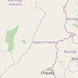
Map view of Luambe National Park

Use this park location map to pinpoint Luambe National Park in Zambia, understand its exact geographic position, and read its mapped placement within the surrounding landscape more clearly.

Pigeon | © OpenStreetMap contributors

Location context for Luambe National Park

Eastern ProvinceLumezi District
Park atlas

Expand your park exploration beyond Luambe, comparing protected areas within Zambia's broader Luangwa River Valley geography

Explore Other Protected Areas and National Parks Near Luambe National Park in Zambia
After exploring Luambe National Park, browse other national parks and protected areas situated within Zambia's Luangwa River Valley, a critical rift system defined by its dynamic river ecosystem. This allows for detailed geographic comparison of Mopane woodlands, riverine landscapes, and shared wildlife recovery efforts across adjacent conservation zones.
National parkMuchinga Province

North Luangwa National Park: National Park Protected Landscape and Regional Geography

Mapped boundaries and geographic context within Muchinga Province.

North Luangwa National Park is a designated national park offering critical insights into Zambia's protected landscapes. This page provides an atlas-driven view of its geographic scope, emphasizing its mapped boundaries and its position within Muchinga Province. Explore the fundamental geography and protected area context that defines North Luangwa National Park for structured landscape discovery.

Area
4,636 km²
Established
1972
IUCN
II
Relief
Mixed relief
National parkZambia

Lukusuzi National Park: Zambia's Protected National Park Geographic Context

Mapped protected area and regional landscape identity for Lukusuzi.

Gain detailed insights into Lukusuzi National Park, a key protected area in Zambia, through its geographic setting and mapped boundaries. This page provides essential context for understanding the park's landscape character and its significance within the national park atlas. Explore the fundamental protected-area geography of this distinct Zambian natural landscape.

IUCN
II
Access
Access unknown
Scope
Terrestrial
National parkZambia

South Luangwa National Park: Zambia's National Park Geographic Atlas and Protected Landscape

Explore mapped boundaries and regional context within this Zambian protected area.

South Luangwa National Park represents a vital national park within Zambia, offering a distinct focal point for atlas-based geographic exploration. This dedicated entry details the park's mapped area and its integration into the surrounding Zambian geography. Users seeking to understand protected landscapes, regional park distributions, and natural terrain context will find South Luangwa National Park a key reference for detailed mapping and landscape analysis.

Area
9,050 km²
Established
1972
IUCN
II
Relief
Mixed relief
National park

Kasungu National Park: Protected Landscape and Geographic Atlas of Central Malawi

Explore Miombo woodlands and dambo grasslands across its mapped terrain.

Kasungu National Park is a key protected area in Malawi, offering insights into the geography of Central Malawi's savanna landscapes. This national park, covering over 2,300 square kilometres, is defined by its characteristic Miombo woodland interspersed with dambo grasslands and riverine habitats. Its location near the Zambian border provides a critical conservation corridor, making it an important entity for understanding regional protected land distribution and landscape ecology within the atlas.

Area
2,316 km²
Established
1970
IUCN
II
Relief
Mixed relief
National parkMuchinga Province

Lavushi Manda National Park: Zambian National Park with Mapped Protected Boundaries

Discover its regional geography and landscape context.

Lavushi Manda National Park represents a distinct protected landscape within Muchinga Province, Zambia. This page provides detailed insights into its geographic identity, mapped park boundaries, and its placement within the broader regional terrain. Utilize this resource for structured atlas exploration of the park's natural context and its significance as a conservation area, offering a foundation for understanding its environmental setting.

Area
1,500 km²
Established
1972
IUCN
II
Relief
Mixed relief
National parkNorthern Province

Isangano National Park: Exploring Its Protected Landscape and Geographic Identity in Northern Province

Discover the mapped boundaries and regional context of this national park.

Isangano National Park stands as a protected national park within the vast geographic expanse of Zambia's Northern Province. This dedicated entry provides critical context for understanding the park's role as a conservation landscape, detailing its physical geography and its position within regional atlas data. Explore the mapped outlines and natural terrain features that define Isangano National Park, offering a foundational view for broader geographic exploration and protected-area research.

Area
840 km²
Established
1972
Relief
Lowland
Climate
Tropical
National parkCentral Province

Kasanka National Park: National Park, Central Province, Zambia - Atlas and Geography

Explore protected landscape boundaries and regional context

Kasanka National Park is a vital protected area situated in Zambia's Central Province. This entry provides detailed geographic context, focusing on its mapped boundaries and its significance as a national park within the larger atlas of protected lands. Users can explore the terrain and natural landscape characteristics that define this specific conservation area and its regional setting.

Area
390 km²
IUCN
II
Relief
Lowland
Scope
Terrestrial
National parkMalawi

Nyika National Park: Malawi National Park Atlas Exploration and Protected Landscape

Discover geographic context and mapped boundaries of this protected area.

Nyika National Park serves as a core entry for understanding Malawi's protected areas and natural landscapes through an atlas lens. Explore the park's designation as a national park, its geographic positioning within Malawi, and the mapped context that defines its protected status. This detail page provides a foundational view for appreciating the park's landscape and its contribution to the regional protected lands overview.

Area
3,134 km²
Established
1966
IUCN
II
Relief
Highland

Common questions about visiting, size, designation, and location context for Luambe National Park

Luambe National Park FAQs for park facts, access, geography, and protected area context
Find quick answers about Luambe National Park, including protected-area facts, park geography, trail and visitor context, and how the park fits into its surrounding country and regional landscape.
MoriAtlas Explorer

Continue Your Protected Areas Search Across the Global Atlas

Deepen your exploration by continuing the structured search for national parks and protected areas worldwide. Utilize the comprehensive filtering capabilities to compare different conservation landscapes and refine your understanding of global park geography. Discover more about the distribution and characteristics of protected natural areas.

Global natural geography