


Mori Atlas logo
Wildlife reserveMiskito Cays

A detailed look at the island geography, reef formations, and coastal wetlands of the North Caribbean Coast Autonomous Region.

Miskito Cays Wildlife Reserve: Mapping the Protected Landscapes of the Caribbean Coast

(Cayos Miskitos y Franja Costera Inmediata)

The Miskito Cays Wildlife Reserve comprises a distinctive archipelago of coral reefs, seagrass beds, and mangrove-fringed islets off the coast of Nicaragua. This protected area stands as a primary component of the wider Moskitia coastal wetland system, serving as a critical habitat for seabirds and marine life within the Caribbean basin. Through this geographic profile, discover the interplay between tidal currents, sand cays, and offshore ecosystems that define this binational marine landscape.

Caribbeancoral reefsseagrass bedsmangrovescaysislands
A digital illustration of a mountainous landscape with a cascading waterfall in the center, a winding river in the foreground, and pine trees lining the edges under a sunset sky.

Miskito Cays

Wildlife reserve

Park overview

Structured park overview, official facts, and landscape profile for Miskito Cays

Miskito Cays park facts, protected area profile, and essential visitor context

Review the core facts for Miskito Cays, including designation, size, terrain, visitor scale, habitats, and operating context in one park-focused overview.

About Miskito Cays

The Miskito Cays are a remote Caribbean archipelago situated along the Mosquito Coast, the long stretch of shoreline that defines the eastern edge of Honduras and northern edge of Nicaragua. Stretching across a relatively shallow shelf of the western Caribbean Sea, the cays form a mosaic of marine and coastal environments where coral reefs, seagrass beds, mangrove-fringed islets, and white sand beaches converge in a continuous ecological system.

The archipelago is composed of 76 reef and cay formations, of which 12 are vegetated enough to qualify as true islands. The largest of these is Cayo Miskito, also called Cayo Mayor, a roughly 37 square kilometer cay near the center of the group. Other notable islands include Maras Cay, Nasa Cay, and Morrison Denis Cay, each contributing to the spatial and ecological diversity of the system. Beyond the visible cays, the area includes extensive estuarine habitat where freshwater from the mainland meets the marine environment, producing productive and biologically rich coastal waters.

On the Nicaraguan side, the cays are administered as part of the North Caribbean Coast Autonomous Region, a politically and culturally distinctive area with strong Miskito and Afro-descendant heritage. The Honduran portion falls within the Gracias a Dios Department, continuing the same Moskitia cultural landscape across the border. This binational setting reinforces the cays' identity as a shared natural and cultural heritage site rather than a purely national park entity.

From an ecological perspective, the Miskito Cays represent one of the most significant coastal wetland and reef complexes in the western Caribbean. Their isolation from major population centers, combined with the relative scarcity of large-scale development along the adjacent mainland coast, has allowed the system to retain much of its natural character. As a result, the cays are valued not only for their scenic and recreational appeal, but as a living reference for what Caribbean coastal ecosystems can look like when large-scale disturbance has been limited.

Quick facts and research context for Miskito Cays

The Miskito Cays form an archipelago of around 76 reef and cay formations in the western Caribbean Sea, of which 12 are vegetated islets large enough to be considered islands. The system covers roughly 27 square kilometers and lies along the Mosquito Coast shared by Nicaragua and Honduras.

The Nicaraguan portion of the cays was designated a protected area in 1991 under the name Miskito Cays Biological Reserve. In 2001 the broader area, including an adjacent strip of mainland coastline, was listed as a Ramsar wetland of international importance. BirdLife International has also recognized the cays and nearby mainland coast as an Important Bird Area.

Protection and recognition

Examine official designation records and management frameworks for Miskito Cays.

Miskito Cays Protection Status and Transboundary Conservation Scope

Miskito Cays brings together documented protection status, management scope, and transboundary conservation attributes. Structured facts outline the recorded administrative framework governing this protected natural landscape.

Protection details

Protection scope
Mixed
Transboundary protection
Yes
Park context

Deeper park guide and search-rich context for Miskito Cays

Miskito Cays history, landscape, wildlife, and travel context

Explore Miskito Cays through its history, landscape character, ecosystems, wildlife, conservation priorities, cultural context, and seasonal travel timing in a structured park guide built for atlas discovery and search intent.

Why Miskito Cays stands out

The Miskito Cays are best known for their combination of Caribbean coral reefs, seagrass meadows, mangrove-lined cays, and white sand beaches set in a remote binational maritime setting. The archipelago is particularly recognized for its ecological richness, its importance as a seabird and coastal bird habitat, and its role as one of the largest and least disturbed coastal wetland complexes along the Caribbean coast of Central America. The cays also stand out for their deep connection to the broader Moskitia region, a culturally and ecologically distinct corridor that includes indigenous Miskito communities, extensive coastal wetlands, and some of the most intact tropical forest and marine ecosystems remaining in the Caribbean basin.
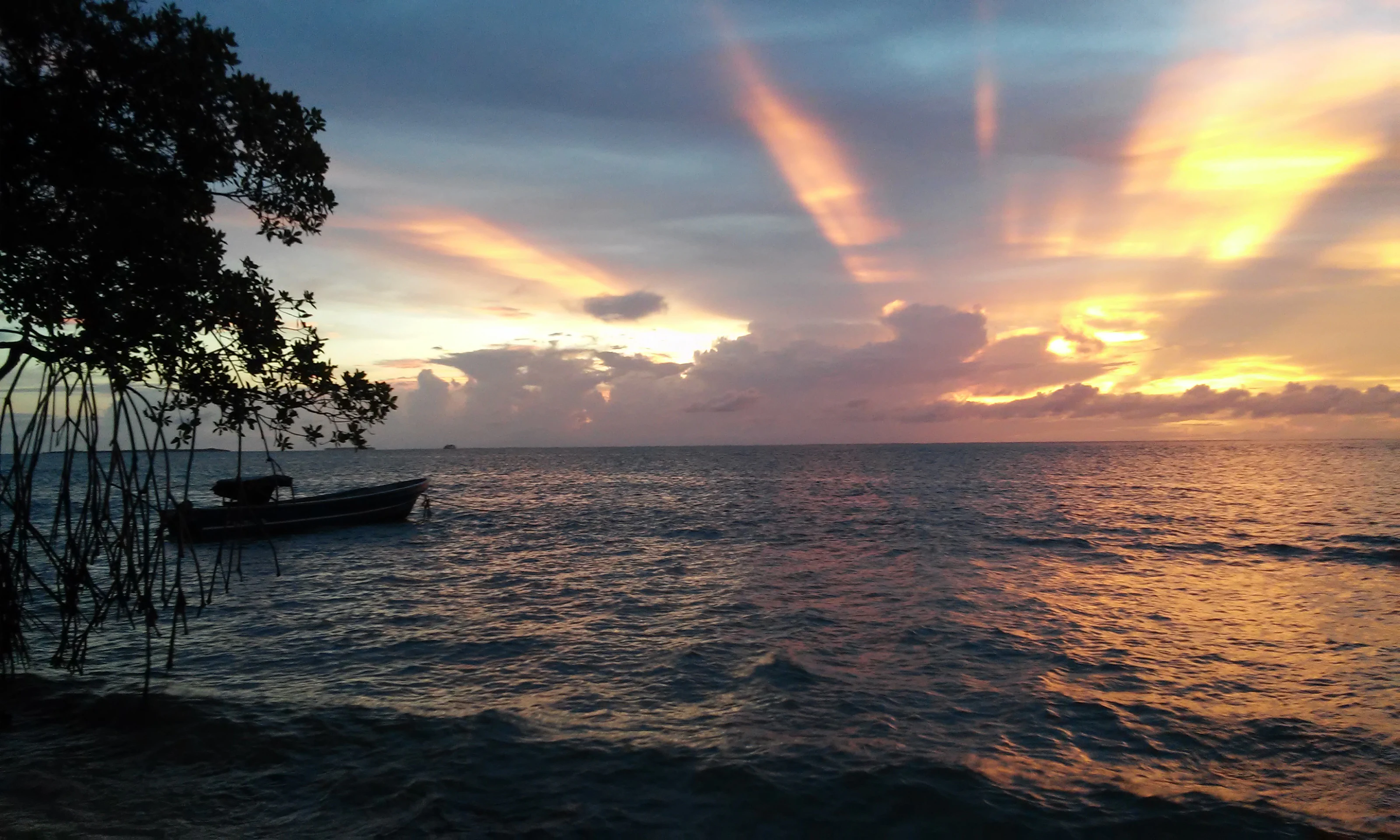
A small wooden boat floating on calm water near a mangrove tree during a golden sunset.
Sunset over the Caribbean Sea in the Miskito Cays.

Miskito Cays history and protected-area timeline

The modern protection history of the Miskito Cays began in 1991, when the Nicaraguan portion of the archipelago was formally designated a protected area under the name Miskito Cays Biological Reserve. This made the cays one of 78 protected areas within Nicaragua's national system and recognized their ecological value at a national level.

In 2001, the significance of the area was elevated internationally when the cays, together with an adjoining stretch of the mainland coast, were inscribed to the Ramsar List of Wetlands of International Importance under the official title Cayos Miskitos y Franja Costera Inmediata. The designation acknowledged the area as one of the most important wetland complexes in the Central American Caribbean, combining marine, estuarine, and coastal habitats within a single protected site.

Subsequently, the Miskito Cays and the adjacent mainland were recognized by BirdLife International as an Important Bird Area, further reinforcing the conservation profile of the region. Together, these designations reflect a layered protection framework in which national reserve status is supported by international recognition for both wetland and bird values.

Miskito Cays landscape and geographic character

The physical landscape of the Miskito Cays is defined by low-lying marine landforms rising only slightly above sea level, set against a backdrop of open Caribbean waters. The archipelago is built from a combination of coral reefs, sand cays, seagrass-covered shoals, and small vegetated islets, with most of the visible terrain sitting just above the waterline. The result is a delicate, shallow-water environment where the boundary between sea and land is constantly reshaped by tides and currents.

The largest cay, Cayo Miskito or Cayo Mayor, anchors the archipelago with a land area of approximately 37 square kilometers. Around it lie smaller formations such as Maras Cay, Nasa Cay, and Morrison Denis Cay, each surrounded by reef structures and fringed by white sand beaches. The shoreline of these islands is shaped by wave action, reef breakwaters, and the accumulation of calcareous sand, giving them a classic Caribbean low-island character.

Behind the cays, the adjacent mainland coast contributes an equally important part of the system's landscape. This coastal fringe, included within the wider Ramsar designation, brings estuaries, mangrove stands, and tidal channels into the same ecological frame as the offshore cays. The combined effect is a landscape where ocean, reef, cay, estuary, and coastal wetland form a continuous gradient rather than separate zones.

Miskito Cays ecosystems, habitats, and plant life

Ecologically, the Miskito Cays sit at the intersection of three highly productive habitat types: coral reef systems, seagrass meadows, and mangrove-dominated estuarine and coastal environments. This combination creates a layered productivity structure typical of healthy Caribbean coastal ecosystems, in which nutrients generated in one habitat support the others, from benthic reef communities to juvenile fish populations in the seagrass beds.

Coral reefs in the area are associated with sand cays that have built up over long periods through the accumulation of reef-derived sediments. Seagrass beds cover large portions of the shallow subtidal zone, providing feeding grounds for marine herbivores and habitat for a wide range of invertebrates and juvenile fish. These habitats also serve as nursery areas for species that later move onto the reefs or out into open water.

The system's estuarine dimension adds a further layer of ecological complexity. Where rivers and coastal drainages from the mainland meet the sea, they create brackish environments that support mangrove forests, salt-tolerant vegetation, and rich microbial communities. Together, these elements make the Miskito Cays a textbook example of an interconnected coastal ecosystem, where the health of the reefs, cays, seagrass beds, and coastal wetlands is tightly linked.

Miskito Cays wildlife and species highlights

The waters and islands of the Miskito Cays support a wide range of marine and bird life typical of the western Caribbean. Seagrass beds and reefs provide habitat for reef fish, invertebrates, sea turtles, and other marine species, while the cays themselves serve as nesting, roosting, and feeding sites for coastal and seabird populations. The mainland fringe included in the broader protected designation adds estuarine and mangrove habitats that support additional bird, fish, and crustacean communities.

The recognition of the area as an Important Bird Area by BirdLife International reflects the importance of the cays and adjacent coast for resident and migratory bird species. The combination of open sea, reef platforms, vegetated islands, and coastal wetlands provides multiple habitat niches in close proximity, allowing different species to occupy reef, shoreline, and interior island environments within a relatively small geographic footprint.

Beyond birds, the broader Moskitia region that surrounds the cays is known for its rich fauna, including populations of marine turtles that nest on sandy beaches, and coastal and estuarine species tied to mangrove and seagrass systems. The relative isolation and low level of large-scale development in the area have helped preserve this wildlife profile, making the cays a regionally significant site for biodiversity conservation.

Miskito Cays conservation status and protection priorities

The conservation profile of the Miskito Cays rests on three overlapping layers of recognition: national reserve status, international wetland protection, and global bird conservation importance. Declared a protected area in 1991 as the Miskito Cays Biological Reserve, the Nicaraguan portion of the archipelago has long been part of the country's formal protected area system.

The 2001 inscription of Cayos Miskitos y Franja Costera Inmediata as a Ramsar site extended this protection to a broader zone that combines offshore reefs and cays with a strip of adjacent mainland coast. The Ramsar designation places the area within a global framework for the conservation of wetlands of international importance, particularly those that support waterbirds, coastal biodiversity, and ecological connectivity between marine and terrestrial systems.

Recognition as an Important Bird Area by BirdLife International adds a third layer, focusing on the site's value for bird populations and reinforcing the connection between the cays and the larger Moskitia landscape. Together, these designations help anchor conservation efforts in a region where pressures from coastal development, fisheries, and changing land use on the mainland remain a concern.

Miskito Cays cultural meaning and human context

The Miskito Cays are closely tied to the Moskitia, one of the most culturally distinctive regions in Central America, which extends across eastern Honduras and the Nicaraguan North Caribbean Coast Autonomous Region. Indigenous Miskito communities, along with Afro-descendant and Creole populations, have shaped the cultural identity of this coast, and the cays are part of the broader territory they have historically inhabited and used.

The region's name derives from the Miskito people, whose presence along the Caribbean coast predates colonial-era borders. The cays are part of the ecological and cultural landscape upon which these communities have traditionally relied for fishing, small-scale movement between coastal settlements, and connection to offshore resources. The binational administrative setting of the cays reflects this deeper cultural continuity across modern political boundaries.

Recognizing this cultural dimension is essential to understanding the Miskito Cays as more than a purely natural site. The protected status of the area sits within a region where indigenous land rights, traditional livelihoods, and conservation initiatives increasingly intersect, and where local communities remain key stakeholders in the future of the archipelago.

Top sights and standout views in Miskito Cays

The Miskito Cays stand out for the unusual combination of ecological, geographic, and cultural features packed into a relatively small Caribbean archipelago. The system unites coral reefs, seagrass meadows, mangrove estuaries, white sand beaches, and vegetated islets within a single, largely intact coastal complex, making it a strong example of interconnected Caribbean marine ecology.

Equally notable is the area's layered protection framework. National reserve status in Nicaragua, Ramsar recognition for the wider coastal zone, and Important Bird Area status from BirdLife International together confirm the cays as a site of both national and international conservation significance. The binational nature of the archipelago, shared between Honduras and Nicaragua within the Moskitia region, adds a further dimension that distinguishes the Miskito Cays from many other Caribbean protected areas.
Monthly climate preview

Measured annual temperature and monthly precipitation patterns from representative coordinates

Miskito Cays Climate Normals and Long-Term Weather by Month

Long-term data records reveal a consistent annual thermal rhythm alongside distinct monthly precipitation variations across Miskito Cays. Examining the complete twelve-month climatology profile provides deeper insight into measured temperature ranges and rainfall averages.
Annual mean28 °C
26 °C28 °C
Jan27°
Feb26°
Mar27°
Apr27°
May28°
Jun28°
Jul28°
Aug28°
Sep28°
Oct28°
Nov28°
Dec27°
Warmest month
September

28.4 °C

Coolest month
February

26.4 °C

Wettest month
October

9.7 mm/day

Driest month
March

0.8 mm/day

Park location guide

Geography guide, regional context, and park location map for Miskito Cays

Miskito Cays park geography, regions, and map view in Nicaragua

Understand where Miskito Cays sits in Nicaragua through a broader geographic reading of the surrounding landscape, nearby location context, and its mapped position within the national park landscape.

How Miskito Cays fits into Nicaragua

Nicaragua is a Central American country spanning 130,375 km² with a population of approximately 6.7 million. It borders Honduras, Costa Rica, the Caribbean Sea, and the Pacific Ocean. The official language is Spanish, and the currency is the Córdoba. Known for its agricultural productivity and cultural diversity, Nicaragua has a history dating back to indigenous civilizations before Spanish conquest in the 16th century.

Wider geography shaping Miskito Cays in Nicaragua

Nicaragua occupies a strategic position in Central America, bordered by Honduras to the north, the Caribbean Sea to the east, Costa Rica to the south, and the Pacific Ocean to the west. The country also shares maritime borders with El Salvador and Colombia. The terrain includes coastal plains, volcanic highlands, and interior valleys. Lake Managua and Lake Nicaragua are major freshwater bodies.

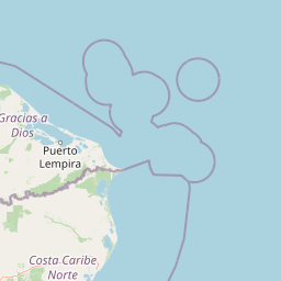
Map view of Miskito Cays

Use this park location map to pinpoint Miskito Cays in Nicaragua, understand its exact geographic position, and read its mapped placement within the surrounding landscape more clearly.

Pigeon | © OpenStreetMap contributors

Location context for Miskito Cays

North Caribbean Coast Autonomous Region
Recorded earthquake history

Explore the Historical Earthquake Record for the Miskito Cays

Access a detailed, filterable archive of recorded seismic events near the Miskito Cays. MoriAtlas provides this factual catalogue to help track historical seismic data and event proximity for this distinct Caribbean coastal reserve.

Miskito Cays Earthquake History

Catalogued events

4 events

Strongest magnitude

Magnitude 4.5

Most recent event

May 1, 2024

This history includes earthquakes recorded inside the park or within 50 km of its borders

Visual reference guide to coral reefs, mangrove estuaries, and low-lying island habitats

Miskito Cays Landscape Photography and Protected Area Scenery

Examine detailed visual documentation of Miskito Cays to understand the physical terrain, coastal habitats, and marine environments that define the archipelago. Photographic records provide clear spatial context for the complex interaction between open Caribbean waters, shallow shoals, and vegetated sand cays.

A small wooden boat floating on calm water near a mangrove tree during a golden sunset.

Park atlas

Compare surrounding marine reserves and coastal wetlands in the Moskitia region

Other Protected Areas and National Parks Near Miskito Cays

Browsing other protected areas near Miskito Cays reveals adjacent marine habitats and coastal reserves across the western Caribbean. Continuing past individual island records helps connect regional conservation corridors and marine ecosystems.
A horizontal watercolor painting showing layers of distant misty mountains behind a foreground of dense tropical foliage and palm-like plants.
Biosphere reserveJinotega Department
136 km away#1 closest

West

Bosawás Biosphere Reserve: Mapping Tropical Rainforest Landscapes and Regional Geography

Extensive primary forest and mountainous terrain in Nicaragua

Examine the geographic layout and protected boundaries of Bosawás Biosphere Reserve. Spanning nearly 20,000 square kilometers across Jinotega Department, this massive biosphere reserve includes the Saslaya massif and essential watersheds, serving as a critical study of tropical rainforest preservation and complex highland topography.

Area
20,000 km²
Established
1997
IUCN
IV
Relief
Mountain
Biosphere reserveGracias a Dios Department
171 km away#2 closest

Northwest

Río Plátano Biosphere Reserve: Protected Geography and Watershed Mapping in Honduras

A sprawling conservation landscape in Gracias a Dios Department

Río Plátano Biosphere Reserve protects one of the last major tracts of undisturbed tropical rainforest along the Central American Caribbean coast. This vast area spans diverse physiographies including brackish coastal lagoons, freshwater mangrove systems, and steep mountain ridges reaching over 1,300 meters. The geography is defined by the Río Plátano watershed, which serves as a vital corridor for endangered species and encompasses significant archaeological sites within its deep forest interior.

Area
5,250 km²
Established
1982
IUCN
II
Relief
Mixed relief
National parkHonduras
204 km away#3 closest

West

Patuca National Park National Park: Understanding its Mapped Protected Boundaries and Honduran Geography

Explore the protected landscape and regional setting of this Honduran park.

Patuca National Park is an important protected area within Honduras, offering a unique opportunity to study its geographic features and conservation significance. As a national park, it provides a critical anchor for understanding regional landscape patterns and mapped protected boundaries in Central America. This entity within the MoriAtlas helps users grasp the specific geographic context and natural terrain associated with Patuca National Park, facilitating detailed atlas-based exploration of its protected status and landscape character.

Area
3,755.84 km²
Established
1999
IUCN
II
Scope
Terrestrial
Nature reserveNicaragua
296 km away#4 closest

South

Indio Maíz Biological Reserve: Protected Landscape and Geographic Identity

Lowland rainforest and riverine systems of southeastern Nicaragua

Indio Maíz Biological Reserve stands as one of Central America's largest protected blocks of tropical forest. Characterized by dense, humid lowlands and extensive river systems like the San Juan, this reserve serves as a critical biodiversity stronghold and a significant example of indigenous-led land stewardship in the region.

Area
2,639 km²
Established
1990
Relief
Lowland
Climate
Tropical
National parkHonduras
About 299 km away#5 closest

West

Sierra de Agalta National Park: National Park within Honduras's Protected Landscape Atlas

Explore mapped boundaries and natural terrain details.

Sierra de Agalta National Park is a protected national park in Honduras, offering valuable insight into the country's natural geography and conservation efforts. As a key entity within the broader atlas of protected lands, this park's mapped boundaries and surrounding terrain provide a foundation for understanding its ecological significance and regional context. Discover the geographic identity of Sierra de Agalta National Park and its contribution to Honduras's protected areas.

Area
207.85 km²
Established
1987
IUCN
II
Relief
Mountain
Nature reserveNicaragua
302 km away#6 closest

Southwest

Cerro Pancasan Natural Reserve: Geographic Overview of a Nicaraguan Protected Forest Hill

Exploring mountain-slope terrain and regional watershed conservation

As a significant hill reserve in western Nicaragua, Cerro Pancasan Natural Reserve protects essential tropical forest cover against agricultural encroachment. This entry provides a detailed look at the reserve's topography, its role in maintaining regional stream flow, and its place within the country-wide SINAP network of protected land.

Scope
Terrestrial
National parkColón Department
About 338 km away#7 closest

Northwest

Capiro Calentura National Park: Honduran National Park Atlas and Protected Landscape

Discover mapped geography and protected area context in Colón Department.

Access detailed geographic information and mapped boundaries for Capiro Calentura National Park, a key protected area within Honduras' Colón Department. This entry offers an atlas-style perspective on the park's landscape and its regional setting, supporting structured discovery of national parks and conservation lands.

Area
80.82 km²
Established
1992
IUCN
II
Climate
Tropical
National parkLimón Province
378 km away#8 closest

South

Tortuguero National Park: Protected Landscape and Regional Geographic Context

National Park mapped in Limón Province, Costa Rica.

Delve into Tortuguero National Park, a significant national park situated in Limón Province, Costa Rica. This entry offers detailed insights into its protected area status, mapped geographic extent, and its role within the regional natural landscape context. Ideal for users seeking a structured atlas view of protected lands and their geographical distribution, providing foundational data for understanding this specific conservation landscape.

Area
312 km²
Established
1975
IUCN
II
Visitors
10K annual

Common questions about visiting, size, designation, and location context for Miskito Cays

Miskito Cays FAQs for park facts, access, geography, and protected area context

Find quick answers about Miskito Cays, including protected-area facts, park geography, trail and visitor context, and how the park fits into its surrounding country and regional landscape.
MoriAtlas Explorer

Continue Your Protected Areas Search Across the Global Atlas

Deepen your exploration by continuing the structured search for national parks and protected areas worldwide. Utilize the comprehensive filtering capabilities to compare different conservation landscapes and refine your understanding of global park geography. Discover more about the distribution and characteristics of protected natural areas.

Global natural geography

