Mori Atlas logo
National parkMochima National Park

Discover the mapped boundaries and regional context of this protected natural area in Sucre.

Mochima National Park: Venezuela's National Park Atlas and Protected Landscape Geography

(Parque Nacional Mochima)

Mochima National Park represents a significant protected landscape within the Sucre region of Venezuela. This page offers detailed insights into its geographic identity, focusing on its mapped park boundaries and its role as a national park in the regional atlas. Explore how this protected area contributes to the conservation landscape and provides context for understanding Venezuela's natural geography.

Marine protected areaCaribbean coastIsland parksCetacean habitatWhale watchingTropical coastline

Mochima National Park

National park

Park overview

Structured park overview, official facts, and landscape profile for Mochima National Park

Mochima National Park park facts, protected area profile, and essential visitor context

Review the core facts for Mochima National Park, including designation, size, terrain, visitor scale, habitats, and operating context in one park-focused overview.

About Mochima National Park

Mochima National Park represents one of Venezuela's most distinctive protected areas, combining terrestrial mountain landscapes with extensive marine environments along the Caribbean coast. The park's territory spans two Venezuelan states, Anzoátegui and Sucre, protecting a coastline that has long been celebrated for its exceptional natural beauty. What sets Mochima apart is its dual character: the exclusively marine western zone in Anzoátegui State gives way to a mountainous inland area that encompasses the Turimiquire Dam watershed in Sucre, while the coastal marine zone includes the Gulf of Santa Fé and the sheltered Mochima Bay. The park was created specifically to preserve the montane forests of the Turimiquire Range alongside the country's eastern Caribbean marine landscapes, making it a comprehensive conservation unit that protects both upland and coastal ecosystems. Its position along the populous corridor between Puerto La Cruz and Cumaná gives it particular significance as a natural area easily accessible to local communities and visitors, while also imposing management challenges related to visitor pressure and coastal development.

Quick facts and research context for Mochima National Park

Mochima National Park covers approximately 94,935 hectares along Venezuela's northeastern Caribbean coast in the states of Anzoátegui and Sucre. Created on December 19, 1973, it was Venezuela's second marine park and protects the entire shoreline between Puerto La Cruz and Cumaná plus 32 offshore islands. The park features mountainous terrain with microclimates ranging from nearly bare cliff faces to dense jungle vegetation, alongside a fully marine western sector and coastal marine areas including the Gulf of Santa Fé and Mochima Bay. Year-round temperatures hover between 20 and 26 degrees Celsius, with trade winds prevailing from November through May.

Protection and recognition

Tracking the official conservation scope and mixed terrestrial and marine boundaries of the park.

Mochima National Park Protection Status and Global Conservation Designation Records

Exploring the documented protection status of Mochima National Park reveals a mixed conservation scope spanning both marine habitats and terrestrial landscapes. Reviewing verified designation records and management frameworks helps researchers evaluate the official conservation status of South American coastal protected areas.

Protection details

Protection scope
Mixed
Park context

Deeper park guide and search-rich context for Mochima National Park

Mochima National Park history, landscape, wildlife, and travel context

Explore Mochima National Park through its history, landscape character, ecosystems, wildlife, conservation priorities, cultural context, and seasonal travel timing in a structured park guide built for atlas discovery and search intent.

Why Mochima National Park stands out

Mochima National Park is best known for its dramatic combination of mountainous coastal terrain and rich Caribbean marine environments. The park's 32 islands, many with pristine beaches and diving sites, anchor a marine ecosystem teeming with cetaceans including humpback whales, Bryde's whales, sperm whales, pilot whales, and several dolphin species. The turtle grass meadows of Mochima Bay support diverse gastropods and mollusks. On land, the Turimiquire Range's montane forests descend through varied microclimates to meet dramatic cliffs that plunge into the Caribbean Sea.

Mochima National Park history and protected-area timeline

Mochima National Park was established on December 19, 1973, becoming only the second marine protected area in Venezuela following the creation of similar coastal parks in the preceding years. The park was named after the town of Mochima, a coastal settlement that has long served as a gateway to the region's natural treasures. Its creation reflected Venezuela's growing commitment in the early 1970s to protecting its Caribbean coastal and marine environments, recognizing that the country's northeastern shoreline represented a unique combination of terrestrial and aquatic ecosystems requiring coordinated conservation. The park's boundaries were drawn to encompass the entire shoreline between Puerto La Cruz and Cumaná, two major coastal cities, along with 32 islands distributed along this stretch of coastline. This comprehensive boundary design ensured protection of both the coastal marine environments and the terrestrial watersheds that flow into them.

Mochima National Park landscape and geographic character

The landscape of Mochima National Park is defined by the dramatic intersection of the Turimiquire mountain range with the Caribbean Sea. This mountainous coastal zone features an extraordinary variety of terrain within a relatively compact area. Some stretches of coastline are characterized by gigantic cliffs that rise nearly vertically from the water's edge, their rock faces sparsely vegetated and dropping directly into deep marine waters. In contrast, other areas of the park feature lush jungle vegetation cascading down to sandy beaches tucked into sheltered coves and inlets. The Gulf of Santa Fé and Mochima Bay provide more protected marine environments, their waters contrasting with the exposed open coast elsewhere in the park. The 32 islands scattered along the coastline add further topographic diversity, ranging from small rocky islets to larger islands with their own beach systems. The Turimiquire Range's foothills descend toward the coast, with the watershed feeding the Turimiquire Dam providing an important hydrological connection between the park's mountain and marine sectors.

Mochima National Park ecosystems, habitats, and plant life

The ecological character of Mochima National Park spans two major domains. The marine environment encompasses both open coastal waters and the more protected waters of Mochima Bay, with extensive turtle grass meadows providing the foundation for a productive coastal ecosystem. The turtle grass beds, dominated by Thalassia testudinum, create essential habitat for numerous marine invertebrates including gastropods and bivalves. The marine waters are notable for their cetacean diversity, with multiple whale and dolphin species recorded in the park's waters. On land, the montane forests of the Turimiquire Range descend through elevation zones that create varied vegetation communities, from lower elevation tropical forest to higher elevation cloud forest in the upland sectors. These forests play a critical role in watershed protection, particularly for the Turimiquire Dam that supplies water to surrounding communities.

Mochima National Park wildlife and species highlights

Mochima National Park supports remarkable marine wildlife, particularly cetaceans that congregate in the productive Caribbean waters off its coast. Humpback whales migrate through these waters, along with Bryde's whales, sperm whales, and pilot whales. Several species of dolphins are also present, including the long-beaked common dolphin that is frequently observed near offshore islands. The marine ecosystem's productivity is underpinned by the turtle grass meadows of Mochima Bay, which support diverse invertebrate populations including the Eared ark clam, Tiger lucine, Buttonsnail, and Turkey wing clam. These species contribute to a complex food web that sustains the larger marine predators. The terrestrial wildlife, while less extensively documented in available sources, includes iguanas and other reptiles that can be observed basking on rocks along the coastline and in marine environments.

Mochima National Park conservation status and protection priorities

Mochima National Park represents a significant conservation achievement as one of Venezuela's earliest marine protected areas and the second marine park in the country. Its establishment in 1973 reflected a recognition that Venezuela's Caribbean coast required formal protection to preserve both marine biodiversity and the terrestrial ecosystems that support it. The park's dual terrestrial-marine design is particularly noteworthy, as it protects not just the coastal marine environment but also the mountainous watersheds, particularly the Turimiquire Range and its associated forest, that maintain the health of downstream marine areas. The protection of the entire shoreline between Puerto La Cruz and Cumaná ensures connectivity between marine habitats, while the 32 islands provide critical nesting and resting sites for marine species. Managing this accessible coastal park presents ongoing challenges related to balancing visitor access with conservation objectives.

Mochima National Park cultural meaning and human context

Mochima National Park is named after the town of Mochima, a traditional coastal settlement whose history is intertwined with the marine environment that now falls within the park's boundaries. The shoreline between Puerto La Cruz and Cumaná has been inhabited for centuries, with small towns and fishing communities developing along this attractive stretch of Caribbean coast. These communities have historically relied on the marine resources of the region, and their traditional relationship with the sea continues to shape the cultural landscape of the park area. The park's proximity to Cumaná, one of Venezuela's oldest colonial cities, adds historical depth to the region's cultural context. The Turimiquire region also holds significance for local communities whose water supply depends on the protected watersheds within the park.

Top sights and standout views in Mochima National Park

The dramatic cliffs plunging into Caribbean waters, the 32 offshore islands with their beaches and diving sites, the whale and dolphin populations visible from shore and boat, the turtle grass meadows of Mochima Bay supporting rich marine life, the montane forests of the Turimiquire Range providing watershed protection, and the accessible shoreline between two major Venezuelan cities make Mochima a distinctive coastal protected area.

Best time to visit Mochima National Park

Mochima National Park can be visited year-round given its tropical climate with temperatures consistently between 20 and 26 degrees Celsius. The period from November through May features warm temperatures and constant trade winds, creating pleasant conditions for beach activities and marine exploration. This dry season offers clearer skies and more predictable weather for island hopping and coastal excursions. From June to October, the park experiences higher humidity and somewhat cooler temperatures, with the increased moisture supporting lush vegetation in the park's terrestrial areas. This green season can offer a different but equally rewarding experience, particularly for those interested in the park's forest environments.
Monthly climate preview

Examine long-term representative temperature ranges and monthly precipitation patterns across the coordinate profile

Mochima National Park Climate Normals and Temperature Rhythms

Representative coordinates record sustained average temperatures between 25 and 28 degrees Celsius alongside distinct monthly precipitation variations across the year. Reviewing the complete twelve-month climate normals provides deeper context for long-term meteorological patterns at the sampled elevation.
Annual mean27 °C
25 °C28 °C
Jan25°
Feb25°
Mar26°
Apr27°
May27°
Jun27°
Jul27°
Aug27°
Sep28°
Oct28°
Nov27°
Dec26°
Warmest month
September

28 °C

Coolest month
January

25.4 °C

Wettest month
August

4.1 mm/day

Driest month
February

0.5 mm/day

Park location guide

Geography guide, regional context, and park location map for Mochima National Park

Mochima National Park park geography, regions, and map view in Venezuela

Understand where Mochima National Park sits in Venezuela through a broader geographic reading of the surrounding landscape, nearby location context, and its mapped position within the national park landscape.

How Mochima National Park fits into Venezuela

Venezuela is a country in northern South America with coastline along the Caribbean Sea and Atlantic Ocean. It borders Colombia, Brazil, Guyana, and Trinidad and Tobago. The country has an area of approximately 916,445 km² and a population of about 31.8 million. Caracas is the capital and largest city. Venezuela consists of 23 states and the Capital District.

Wider geography shaping Mochima National Park in Venezuela

Venezuela is located on the northern coast of South America. The continental territory is bordered by the Caribbean Sea and Atlantic Ocean to the north, Colombia to the west, Brazil to the south, and Guyana to the east. Trinidad and Tobago lies to the northeast. The country includes various islands and islets in the Caribbean Sea known as the Federal Dependencies.

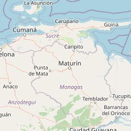
Map view of Mochima National Park

Use this park location map to pinpoint Mochima National Park in Venezuela, understand its exact geographic position, and read its mapped placement within the surrounding landscape more clearly.

Pigeon | © OpenStreetMap contributors

Location context for Mochima National Park

AnzoáteguiSucre
Natural feature types

Explore the Topographic and Marine Features of Mochima National Park

Navigate the complex geography of this Caribbean protected area by examining its named islands, coastal inlets, and mountain terrain. MoriAtlas provides a clear structure for identifying significant natural landmarks across the diverse coastal environment of Mochima National Park.
Recorded earthquake history

Review the Historical Earthquake Catalogue for Mochima National Park

Explore a comprehensive record of documented seismic events occurring near the coastal and marine terrain of Mochima National Park. This database allows for the analysis of past earthquake activity, providing precise data points for each recorded epicentre in this significant protected area.

Mochima National Park Earthquake History

Catalogued events

20 events

Strongest magnitude

Magnitude 5.4

Most recent event

Jul 25, 2024

This history includes earthquakes recorded inside the park or within 50 km of its borders

Park atlas

Map the broader network of marine and coastal protected areas across Venezuela's northeastern Caribbean region.

Explore Related National Parks and Protected Areas Near Mochima National Park

Continue your exploration of Venezuela's protected landscapes by browsing other national parks and protected areas located in the vicinity of Mochima National Park. This regional overview allows you to compare diverse marine environments, coastal mountains, and island ecosystems, offering valuable geographic context for conservation efforts across the Caribbean coast.
Natural monumentNueva Esparta
52 km away#1 closest

Northeast

Monumento natural Tetas de María Guevara: Protected Land and Coastal Geography

Analyzing the arid hills and mangrove lagoons of Isla de Margarita

Spanning 1,670 hectares in the Municipio Tubores, Monumento natural Tetas de María Guevara features a distinctive silhouette formed by twin hills. This protected landscape provides critical geographic contrast, pairing dry scrubland terrain with vital coastal wetland systems. The area serves as a significant natural reference point and ecological component within the broader Nueva Esparta island region.

Area
16.7 km²
Established
1974
Relief
Upland
Climate
Arid
Watercolor painting of a lake surrounded by forest with mountains in the background
National parkVenezuela
55 km away#2 closest

Northeast

Laguna de La Restinga National Park: Venezuela's National Park with Extensive Mangrove Ecosystem

Explore its mapped channels, vital bird habitats, and coastal geography.

Laguna de La Restinga National Park stands as a key protected area within Venezuela, renowned for its expansive shallow salt lagoon and dense mangrove forests. The park's geography is defined by 18 kilometers of natural channels that weave through mangrove islands, offering a unique visual and navigational landscape. As a designated Ramsar Wetland, it is a critical habitat for numerous waterfowl species, providing rich opportunities for landscape and birdwatching discovery. The surrounding terrain reflects the arid conditions typical of the Venezuelan Dry Forest province, contrasting with the vibrant aquatic ecosystem.

Area
188 km²
Established
1974
IUCN
II
Relief
Lowland
National parkNueva Esparta
57 km away#3 closest

Northeast

Parque nacional Laguna de La Restinga: Protected Coastal Lagoon and Island Geography

Wetland ecosystems of Nueva Esparta, Venezuela

Parque nacional Laguna de La Restinga protects an extensive coastal lagoon bordered by dense mangrove forests and arid coastal scrub on Isla de Margarita. This critical wetland habitat serves as a biological bridge between the two halves of the island, offering a complex network of channels and sandy flats that support diverse coastal species and marine turtle nesting sites.

Area
188.62 km²
Established
1974
IUCN
II
Relief
Lowland
National parkMonagas
59 km away#4 closest

East

Cueva del Guácharo National Park: Venezuela's Protected Natural Landscape

Mapping protected areas and natural terrain in Monagas.

Cueva del Guácharo National Park represents a distinct protected landscape within Venezuela's Monagas region. This entry provides essential context for understanding the park's geographic scope, mapped boundaries, and role as a national park. It is designed to facilitate detailed atlas exploration of protected natural areas and their regional landscape context, offering a foundation for understanding Venezuela's conservation geography.

Area
627 km²
Established
1975
IUCN
II
Relief
Mountain
National parkNueva Esparta
65 km away#5 closest

Northeast

Cerro El Copey National Park: Mapped Protected Area in Nueva Esparta

Explore the geographic context and landscape of this national park.

Cerro El Copey National Park offers a distinct protected landscape within Nueva Esparta, Venezuela. This page details the park's geographic identity, its mapped boundaries, and its significance as a national park. Investigate the terrain and regional context to understand the protected area's ecological and geographical footprint, providing essential data for atlas-driven exploration.

Area
71 km²
Established
1974
IUCN
II
Relief
Mountain
Watercolor painting of a lagoon surrounded by green vegetation and mountains in the background
National parkMiranda State
97 km away#6 closest

West

Laguna de Tacarigua National Park: Protected Area and Miranda State Geography

Mapped natural landscape and park boundaries in Venezuela.

Laguna de Tacarigua National Park is a designated national park offering critical protected landscape features within Miranda State. This park provides essential context for understanding Venezuela's protected areas, with a focus on its mapped boundaries and regional geographic setting. Dive into the atlas-style details to comprehend its place in the natural landscape.

Area
391 km²
Established
1974
IUCN
II
Relief
Lowland
National parkSucre State
122 km away#7 closest

Northeast

Turuépano National Park: National Park Protected Landscape and Geographic Context

Explore the mapped boundaries and natural terrain of Sucre State's national park.

Investigate Turuépano National Park, a protected national park situated within Sucre State, Venezuela. This entry provides detailed geographic context and information on its mapped protected-area boundaries, essential for understanding its role in the region's natural landscape atlas. Explore the specific terrain and protected land features that define this significant Venezuelan park.

Area
726 km²
Established
1991
IUCN
II
Relief
Lowland
Watercolor painting showing a winding river flowing through a landscape with rolling hills in the background
National parkVenezuela
159 km away#8 closest

West

El Ávila National Park: Venezuela's Premier Coastal Mountain National Park Exploration

Discover diverse terrain, mapped boundaries, and unique geographic context.

El Ávila National Park offers an exceptional gateway into Venezuela's mountainous protected landscapes. This national park features a dramatic rise from the Caribbean coast into varied terrain, including unique cloud forest and alpine zones. Its mapped geography showcases steep slopes, deep ravines, and remarkable elevation changes, providing a significant atlas-style study of coastal mountain environments. Exploring El Ávila National Park reveals a vital natural barrier and a rich ecosystem supporting diverse flora and fauna, making it a key destination for understanding regional protected areas.

Area
819 km²
Established
1958
IUCN
II
Relief
Mountain

Common questions about visiting, size, designation, and location context for Mochima National Park

Mochima National Park FAQs for park facts, access, geography, and protected area context

Find quick answers about Mochima National Park, including protected-area facts, park geography, trail and visitor context, and how the park fits into its surrounding country and regional landscape.
MoriAtlas Explorer

Continue Your Protected Areas Search Across the Global Atlas

Deepen your exploration by continuing the structured search for national parks and protected areas worldwide. Utilize the comprehensive filtering capabilities to compare different conservation landscapes and refine your understanding of global park geography. Discover more about the distribution and characteristics of protected natural areas.

Global natural geography