Mori Atlas logo
National parkMombasa Marine Park

Discover the mapped boundaries and regional context of this East African protected area.

Mombasa Marine Park: Kenya National Park Protected Landscape and Geographic Atlas

(Mombasa Marine National Park and Reserve)

Mombasa Marine Park stands as a designated national park within Kenya, representing a key protected landscape in East Africa. This page details its geographic setting, mapped boundaries, and role within the broader atlas of conservation areas. Understand the unique context of Mombasa Marine Park as a protected natural entity for structured geographic discovery and analysis.

Marine ParkCoral ReefsCoastal KenyaMarine ConservationIndian OceanSea Turtles

Mombasa Marine Park

National park

Park overview

Structured park overview, official facts, and landscape profile for Mombasa Marine Park

Mombasa Marine Park park facts, protected area profile, and essential visitor context

Review the core facts for Mombasa Marine Park, including designation, size, terrain, visitor scale, habitats, and operating context in one park-focused overview.

About Mombasa Marine Park

Mombasa Marine National Park and Reserve represents a vital marine protected area along Kenya's Indian Ocean coastline, situated immediately adjacent to the coastal city of Mombasa. The park was established in 1986 and formally recognized through legislation in 1987 as a response to growing concerns about environmental degradation, overfishing, and the declining health of coral reef ecosystems in the region. The protected area is divided into two distinct zones: a fully protected national park covering 10 square kilometers where all extractive activities are prohibited, and a surrounding marine reserve of 200 square kilometers where certain sustainable uses may be permitted under regulation. The park's location near one of Kenya's primary tourism centers has made it the most frequently visited marine protected area in the country. Visitors engage in activities including snorkeling, scuba diving, boat excursions, recreational fishing, windsurfing, and water skiing. The park's coral reefs form the centerpiece of its ecological value, providing habitat, breeding grounds, and feeding areas for countless marine species while also serving as natural breakwaters that protect the coastline from wave erosion. The marine environment maintains warm tropical conditions throughout the year, with sea surface temperatures varying between 25 and 31 degrees Celsius and consistent salinity levels that support diverse marine life.

Quick facts and research context for Mombasa Marine Park

Mombasa Marine Park is situated on Kenya's coast adjacent to the city of Mombasa, the nation's second-largest city and a major tourism hub. The protected area consists of two zones: a smaller fully protected national park spanning 10 square kilometers and a larger marine reserve covering 200 square kilometers. The park was officially established through legislation in 1987 to address concerns about overfishing, coral reef degradation, and declining tourism revenue. It protects coral reef ecosystems that support numerous marine species including crabs, starfish, stonefish, sea cucumbers, sea urchins, corals, turtles, and sea grasses. The reserve also provides habitat for migratory bird species, notably the crab plover. The park's tropical marine environment maintains consistent warm temperatures year-round, creating favorable conditions for coral growth and diverse marine life.

Park context

Deeper park guide and search-rich context for Mombasa Marine Park

Mombasa Marine Park history, landscape, wildlife, and travel context

Explore Mombasa Marine Park through its history, landscape character, ecosystems, wildlife, conservation priorities, cultural context, and seasonal travel timing in a structured park guide built for atlas discovery and search intent.

Why Mombasa Marine Park stands out

Mombasa Marine Park is best known for its accessible and well-developed coral reef system along Kenya's coastline. The park offers exceptional snorkeling and scuba diving opportunities in relatively shallow waters teeming with marine life. Beyond its underwater attractions, the park serves as a crucial habitat for sea turtles, various coral species, and sea grass beds that support broader coastal marine ecosystems. The reserve's combination of protected coral reefs, diverse fish populations, and proximity to Mombasa's tourist infrastructure makes it a flagship destination for marine tourism in East Africa. The area also supports significant birdlife, with the crab plover being a particularly notable migratory species that inhabits the coastal zones.

Mombasa Marine Park history and protected-area timeline

Mombasa Marine Park's formal establishment in 1986 and subsequent legislation in 1987 represented a critical response to mounting environmental pressures on Kenya's coastal marine ecosystems. Prior to protection, the area faced significant threats from overfishing, destructive fishing practices such as coral reef stripping, and growing concern that environmental degradation would undermine the tourism industry that relied on the region's natural attractions. The legislation designated the area as both a National Park and a marine park, reflecting dual objectives of wildlife protection and coral reef preservation. Initial enforcement proved challenging, as fishing and poaching activities continued despite the new legal framework. Recognizing the inadequacy of daytime patrols alone, authorities introduced night-time patrol operations in 1992 to address poaching more effectively. These measures, combined with strengthened legislation to ban fishing within the protected zones, eventually succeeded in achieving full protection by 1994. The evolution from initial designation to effective management demonstrates the ongoing commitment required to maintain marine protected areas and the gradual process of building effective conservation frameworks in practice.

Mombasa Marine Park landscape and geographic character

The landscape of Mombasa Marine Park is defined by its marine environment rather than terrestrial features, encompassing coastal waters, coral reef formations, sandy seabeds, and sea grass beds that create a diverse underwater topography. The park's waters lie adjacent to Mombasa's popular beach areas, where the gradual shelving of the continental shelf creates accessible conditions for snorkeling and diving along fringing reef systems. Coral formations create complex three-dimensional structures that support intricate marine ecosystems, while adjacent sandy areas and sea grass meadows provide additional habitat diversity. The underwater terrain varies from relatively shallow reef flats ideal for beginner snorkelers to deeper sections that accommodate more experienced divers. The coastal setting means the park is influenced by typical tropical marine conditions, with warm year-round temperatures and stable salinity supporting continuous coral growth and marine productivity.

Mombasa Marine Park ecosystems, habitats, and plant life

The marine ecosystem within Mombasa Marine Park exemplifies tropical coastal biodiversity along the East African coast. The park's coral reefs support a complex web of marine life, with coral formations including various species of hard and soft corals that create essential habitat structure. Sea grass beds occupy significant portions of the marine floor, particularly in shallower protected areas, and serve as critical feeding and nursery grounds for species including green turtles. The ecosystem supports diverse invertebrate populations including numerous crab species, various sea urchins, starfish, and sea cucumbers that play important roles in nutrient cycling and reef health. Water conditions in the park remain consistently favorable for marine life, with surface temperatures between 25 and 31 degrees Celsius throughout the year, stable salinity regimes, and moderate nutrient levels that support productive but not overly enriched conditions.

Mombasa Marine Park wildlife and species highlights

Mombasa Marine Park protects diverse marine wildlife that depends on its coral reef and sea grass habitats. The park's waters host numerous fish species that inhabit reef structures, along with significant populations of sea turtles that use sea grass areas for feeding. Invertebrate wildlife includes various crab species, multiple sea urchin types, starfish of several species, and sea cucumbers that contribute to the ecosystem's overall health and functioning. The coral formations themselves support countless smaller organisms that form the base of the food web. Beyond marine species, the reserve area provides habitat for migratory birds including the distinctive crab plover, which is particularly associated with coastal environments and mudflats. The combination of reef, sandy, and sea grass habitats creates a mosaic of environments that supports wildlife throughout different stages of their life cycles.

Mombasa Marine Park conservation status and protection priorities

Mombasa Marine Park represents a critical conservation priority for Kenya's marine biodiversity and coastal ecosystem health. The protected area was established specifically to address the devastating impacts of overfishing and destructive coral reef exploitation that threatened both marine life and the tourism economy dependent on healthy reefs. The establishment of both a strictly protected national park zone and a larger reserve zone reflects a recognition that marine ecosystems require different levels of protection based on sensitivity and ecological importance. The transition from initial protection with ongoing violations to full effective protection by 1994 demonstrates the importance of sustained enforcement and adaptive management. The park's coral reefs continue to face challenges from climate change, coastal development, and regional environmental pressures, making ongoing conservation efforts essential for maintaining the biodiversity and ecosystem services the area provides.

Mombasa Marine Park cultural meaning and human context

Mombasa Marine Park exists within a region of significant cultural and historical importance, as Mombasa has served as a major coastal settlement and trading port for centuries. The park's establishment reflects modern recognition of the value of marine ecosystems in a region where coastal communities have historically depended on marine resources for livelihoods and food security. The park's proximity to Mombasa's tourism infrastructure means it exists within a landscape where traditional fishing communities and modern beach tourism coexist, sometimes in tension. Conservation efforts have had to balance the interests of local fishing communities who historically utilized the area with the need to protect marine resources from overexploitation. The park's designation as a marine protected area represents a relatively recent intervention in the long history of human interaction with this coastal marine environment.

Top sights and standout views in Mombasa Marine Park

The standout features of Mombasa Marine Park center on its accessible coral reef ecosystems that allow visitors to directly observe tropical marine life in a relatively convenient location. The park's status as Kenya's most visited marine protected area reflects its combination of natural beauty, biodiversity, and accessibility from Mombasa's tourism infrastructure. Visitors can experience coral reefs through snorkeling in relatively shallow waters or more extensively through scuba diving that reveals the full complexity of reef ecosystems. Beyond underwater attractions, the park provides opportunities for various water sports and boat-based activities that showcase the coastal marine environment. The presence of sea turtles, diverse fish communities, and seasonal bird populations adds to the wildlife viewing opportunities available within the reserve.

Best time to visit Mombasa Marine Park

Mombasa Marine Park can be visited throughout the year due to its tropical location and consistent marine conditions, with water temperatures remaining warm between 25 and 31 degrees Celsius across all seasons. The park's marine environment is characterized by stable conditions, though visitors planning activities should be aware that coastal weather patterns can influence sea conditions and visibility. The most comfortable period for land-based activities tends to coincide with Kenya's drier seasons, though marine conditions for diving and snorkeling remain viable year-round. The park's position near Mombasa means it remains accessible regardless of broader safari circuit seasons, making it a viable addition to Kenya itineraries throughout the year.
Monthly climate preview

Long-term representative coordinate records detailing monthly thermal and moisture patterns

Mombasa Marine Park Climate Normals, Annual Temperature and Precipitation Rhythm

Representative baseline measurements for Mombasa Marine Park trace a measured annual cycle of sustained warm temperatures and shifting daily precipitation volumes across twelve months. Reviewing the complete monthly climate profile provides deeper context on long-term temperature ranges and precipitation rhythms at this coastal protected area.
Annual mean27 °C
25 °C28 °C
Jan27°
Feb27°
Mar28°
Apr28°
May27°
Jun26°
Jul25°
Aug25°
Sep25°
Oct26°
Nov27°
Dec28°
Warmest month
April

28.2 °C

Coolest month
August

25 °C

Wettest month
May

6.8 mm/day

Driest month
February

0.7 mm/day

Park location guide

Geography guide, regional context, and park location map for Mombasa Marine Park

Mombasa Marine Park park geography, regions, and map view in Kenya

Understand where Mombasa Marine Park sits in Kenya through a broader geographic reading of the surrounding landscape, nearby location context, and its mapped position within the national park landscape.

How Mombasa Marine Park fits into Kenya

Kenya is a presidential republic in East Africa and the seventh-most populous country on the continent. Its capital is Nairobi, and it borders five countries and the Indian Ocean. The country features significant geographic diversity including Mount Kenya, the Rift Valley, and coastal regions.

Wider geography shaping Mombasa Marine Park in Kenya

Kenya is located in East Africa, bordering South Sudan to the northwest, Ethiopia to the north, Somalia to the east, Tanzania to the southwest, and Uganda and Lake Victoria to the west. The southeastern border meets the Indian Ocean. The geography includes the Rift Valley highlands with Mount Kenya, coastal plains, and northern arid regions.

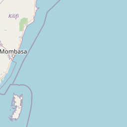
Map view of Mombasa Marine Park

Use this park location map to pinpoint Mombasa Marine Park in Kenya, understand its exact geographic position, and read its mapped placement within the surrounding landscape more clearly.

Pigeon | © OpenStreetMap contributors
Park atlas

Extend your exploration by mapping nearby protected areas, comparing the coastal and marine landscapes surrounding Mombasa Marine Park.

Explore Nearby Protected Areas: Discover Other National Parks Near Mombasa Marine Park and Coastal Kenya

Discover additional national parks and other protected areas near Mombasa Marine Park, including marine reserves and varied coastal landscapes across the surrounding region. Comparing these park entities provides valuable geographic context for coastal conservation efforts and the spread of natural protected zones in East Africa.
Watercolor illustration of a hilly landscape with green and pink hues, showing trees, distant hills, and a light sky
National parkKenya
About 81 km away#1 closest

Southwest

Kisite-Mpunguti Marine National Park: Kenya's Coastal Protected Marine Landscape

Mapped coral reefs and diverse marine ecosystems.

As Kenya's foremost marine national park, Kisite-Mpunguti Marine National Park presents an unparalleled opportunity to explore a thriving underwater world. Its protected boundaries encompass remarkable coral formations and a rich tapestry of marine species, including diverse fish populations, sea turtles, and dolphins. This park is a cornerstone of coastal conservation, offering valuable insights into marine geography and ecosystem health for those seeking detailed landscape context.

Area
39 km²
Established
1973
IUCN
II
Relief
Lowland
Marine protected areaKenya
About 82 km away#2 closest

North

Watamu Marine National Park: Coastal Protected Marine Landscape in Kenya

Explore mapped boundaries and regional geography.

Watamu Marine National Park represents a crucial marine protected area situated on Kenya's coastline, contributing significantly to the country's conservation landscape. This designation underscores its role in preserving coastal and underwater geography, making it a key entity for atlas exploration of protected marine environments. Understanding its specific geographic scope and mapped protected boundaries is essential for comprehending Kenya's broader environmental atlas.

Established
1968
Relief
Lowland
Climate
Tropical
Access
Moderate access
National parkCoast Province
About 89 km away#3 closest

North

Arabuko Sokoke National Park: National Park Atlas and Geographic Identity in Coast Province

Mapped protected area within Kenya's coastal region.

Arabuko Sokoke National Park is identified as a protected national park situated within the historical Coast Province of Kenya. This entry offers a focused examination of its protected landscape and geographic significance, contributing to a structured atlas of protected areas. Users can explore the park's mapped boundaries and its positioning within the regional geography, providing essential context for understanding this natural landscape.

Area
6 km²
Established
1990
IUCN
II
Relief
Lowland
National parkKenya
About 91 km away#4 closest

Northwest

Tsavo East National Park: Kenya's Protected Natural Landscape for Geographic Exploration

Explore mapped boundaries and regional park geography.

Tsavo East National Park in Kenya offers a rich entry point for understanding protected landscapes and regional geography. As a designated national park, its mapped boundaries and natural terrain provide essential context for geographic exploration within East Africa. This page serves as a focused discovery point for the park's specific environmental attributes and its role in the broader atlas of protected areas.

Area
13,747 km²
Established
1948
IUCN
II
Relief
Lowland
Marine protected areaKenya
About 97 km away#5 closest

North

Malindi-Watamu Marine Protected Area and Regional Coastal Geography

Kenya Indian Ocean marine and wetland habitat

Analyze the protected landscape of Malindi-Watamu, covering coral reefs, tidal sandflats, and mangrove forests along the Kenyan coastline. This area serves as a significant biosphere reserve, integrating marine conservation with complex intertidal geography and seasonal seabird habitats within its protected boundaries.

Area
245 km²
Relief
Lowland
Climate
Tropical
Scope
Marine
Watercolor painting showing a landscape with mountains in the background, green hills in the midground, and water or wetland in the foreground
National parkKenya
About 98 km away#6 closest

Northeast

Malindi Marine National Park: Kenya's National Park Atlas of Coastal Protected Lands

Explore mapped marine geography and protected landscape context.

Malindi Marine National Park is a protected national park situated along Kenya's coast, contributing to the nation's atlas of conservation landscapes. This entry details the park's specific geographic identity, its mapped boundaries, and its role as a protected marine environment. Engage with its regional context and understand how its protected status shapes its unique landscape for a deeper geographic appreciation.

Relief
Lowland
Climate
Tropical
Access
Access unknown
Scope
Marine
National parkTanzania
About 118 km away#7 closest

West

Mkomazi National Park: Tanzania's Vast Protected Savanna Landscape and Wildlife Geography

Explore its mapped terrain and conservation significance within East Africa.

Mkomazi National Park is a critical protected landscape in Tanzania, spanning over 3,200 square kilometers of classic East African semi-arid savanna woodland. This national park offers a unique atlas-style view into conservation success, particularly for its black rhinoceros sanctuary and African wild dog programs. Its landscape is characterized by rolling terrain and Acacia-Commiphora vegetation, forming a vital transboundary conservation area with Kenya that supports significant wildlife migration corridors and provides a distinct geographic context within the broader regional atlas.

Area
3,234 km²
Established
2006
IUCN
II
Visitors
1.6K annual
National parkTaita-Taveta County
About 137 km away#8 closest

West

Tsavo West National Park: Kenya's Protected National Park and Regional Geography

Explore mapped boundaries and natural landscapes in Taita-Taveta County.

Tsavo West National Park offers a focused exploration of protected landscape and regional geography within Kenya. Discover the mapped extent of this national park, understanding its role as a conservation area in Taita-Taveta County. This entry provides key geographic context and atlas-style information, highlighting the natural terrain and protected boundaries for detailed discovery.

Area
9,065 km²
Established
1948
IUCN
II
Relief
Mixed relief

Common questions about visiting, size, designation, and location context for Mombasa Marine Park

Mombasa Marine Park FAQs for park facts, access, geography, and protected area context

Find quick answers about Mombasa Marine Park, including protected-area facts, park geography, trail and visitor context, and how the park fits into its surrounding country and regional landscape.
MoriAtlas Explorer

Continue Your Protected Areas Search Across the Global Atlas

Deepen your exploration by continuing the structured search for national parks and protected areas worldwide. Utilize the comprehensive filtering capabilities to compare different conservation landscapes and refine your understanding of global park geography. Discover more about the distribution and characteristics of protected natural areas.

Global natural geography