Mori Atlas logo
National parkTsavo West National Park

Discover the mapped natural terrain and protected boundaries of this Kenyan national park.

Tsavo West National Park: Protected Landscape and Regional Geography in Kenya

Tsavo West National Park represents a significant protected area within Taita-Taveta County, Kenya. This page serves as a gateway to understanding its distinct geographic identity, exploring its mapped landscape, and appreciating its context within the broader regional geography. Engage with the structured data to visualize the park's protected boundaries and its natural terrain.

Savanna wildernessBig Five habitatRhino conservationRock climbingVolcanic landscapeRiverine ecosystems

Tsavo West National Park

National park

Park overview

Structured park overview, official facts, and landscape profile for Tsavo West National Park

Tsavo West National Park park facts, protected area profile, and essential visitor context
Review the core facts for Tsavo West National Park, including designation, size, terrain, visitor scale, habitats, and operating context in one park-focused overview.

About Tsavo West National Park

Tsavo West National Park represents one of Kenya's most significant conservation areas, protecting a vast expanse of wilderness in the country's southeastern region. The park's location along the ancient trade routes between the coast and interior is reflected in its rich archaeological heritage, with evidence of Late Stone Age settlements dating back 6,000 to 1,300 years along the Galana River. Swahili merchants traded ivory, catskins, and other goods with local inhabitants as early as 700 CE, with trade networks extending from the Swahili Coast into the Tsavo region. The park's dramatic landscapes were shaped by volcanic activity, creating a terrain of volcanic plains, rugged cliffs, and rocky outcrops that define its distinctive character. Today, Tsavo West offers visitors an exceptional wilderness experience with well-developed infrastructure including a network of roads, accommodation options, and guided activities. The park's proximity to the A109 highway connecting Nairobi and Mombasa makes it accessible to visitors while maintaining its wild character. The Tsavo Conservation Area, of which Tsavo West is a central component, represents one of the largest ecosystem complexes in East Africa, providing critical habitat for migrating elephants and numerous other species.

Quick facts and research context for Tsavo West National Park

Tsavo West National Park is located in southeastern Kenya, approximately 240 kilometers southeast of Nairobi along the historic Nairobi-Mombasa highway. The park covers 9,065 square kilometers of diverse terrain and was established in 1948, originally home to Orma pastoralists, Maasai herders, and Waata hunter-gatherers who were relocated during gazettment. The park is managed by the Kenya Wildlife Service and features the Mzima Springs as its most famous water source. The area gained international notoriety in 1898 when two maneless lions killed dozens of railway workers during the construction of the Uganda Railway, a story immortalized inLt.-Col. John Henry Patterson's 1907 book "The Man-eaters of Tsavo." The park contains a dedicated rhino reserve and offers exceptional rock climbing opportunities on gneiss cliffs.

Park context

Deeper park guide and search-rich context for Tsavo West National Park

Tsavo West National Park history, landscape, wildlife, and travel context
Explore Tsavo West National Park through its history, landscape character, ecosystems, wildlife, conservation priorities, cultural context, and seasonal travel timing in a structured park guide built for atlas discovery and search intent.

Why Tsavo West National Park stands out

Tsavo West is best known for its spectacular scenery and the Mzima Springs, a series of natural springs that produce crystal-clear water and support abundant hippos and crocodiles. The park features excellent wildlife viewing, particularly for eastern black rhinos, elephants, Cape buffalo, lions, and leopards. The rhino reserve within the park provides critical protection for one of Kenya's most endangered species. The Kichwa Tembo cliffs offer some of Kenya's finest rock climbing on solid gneiss walls, with Kilimanjaro visible on clear days. The park's diverse habitats range from volcanic plains and rocky outcrops to riverine forests and open savanna, supporting exceptional biodiversity.

Tsavo West National Park history and protected-area timeline

The human history of Tsavo West stretches back thousands of years, with archaeological evidence demonstrating continuous Late Stone Age occupation along the Galana River from approximately 6,000 years ago. These early inhabitants hunted wild animals, practiced fishing, and kept domesticated livestock, with settlement concentrated near water sources and rock shelters. The 19th century brought increased contact with coastal traders, as Swahili merchants exchanged goods including cowry shells and beads with local populations. British and German explorers documented the Orma and Waata peoples traversing the "nyika" during this period. The construction of the Uganda Railway through Tsavo in 1898 marked a transformative moment, famously accompanied by the "Maneaters of Tsavo," two maneless lions that killed at least 28 workers and became the subject of Lt.-Col. John Henry Patterson's influential 1907 book. In 1948, Tsavo was gazetted as a national park, and the indigenous Orma, Maasai, and Waata populations were relocated to Voi, Mtito Andei, and surrounding areas. Following Kenyan independence in 1963, hunting was banned and management transferred to the Kenya Wildlife Service. The park has since become a premier safari destination, attracting photo-tourists from around the world.

Tsavo West National Park landscape and geographic character

Tsavo West National Park showcases a dramatic and varied landscape shaped by ancient volcanic activity and erosion. The terrain encompasses volcanic plains dotted with rocky outcrops, steep gneiss cliffs rising hundreds of meters above the savanna, and ancient rock formations that create a visually striking wilderness environment. The Kichwa Tembo cliffs, rising approximately 300 meters in height, represent the park's most impressive geological feature and offer exceptional rock climbing opportunities. The landscape transitions from open grass plains dotted with acacia trees to denser riverine vegetation along the Tsavo River and Galana River corridors. Mzima Springs, fed by underground streams from the surrounding hills, creates a verdant oasis supporting hippos and crocodiles in crystal-clear pools. The park's varied elevation and geological diversity support distinct vegetation zones, from semi-arid grasslands to denser woody vegetation in protected valleys.

Tsavo West National Park ecosystems, habitats, and plant life

The ecological diversity of Tsavo West National Park reflects its varied landscape and position in southeastern Kenya. The park encompasses multiple habitat types including volcanic plains, rocky outcrops, riverine forests, savanna grasslands, and spring-fed wetlands. The Mzima Springs system represents a unique aquatic habitat, producing clean water that supports hippos, crocodiles, and diverse fish species. The park's position within the Tsavo Conservation Area creates a vast contiguous habitat that supports seasonal migrations of elephants and other large mammals. The rhino reserve provides critical protection for the eastern black rhinoceros, one of Africa's most endangered large mammals. The varied terrain and vegetation support a wide range of bird species, with raptors particularly common around the cliff formations where eagles, vultures, and falcons circle on thermals.

Tsavo West National Park wildlife and species highlights

Tsavo West National Park supports an impressive array of wildlife, with the park's diverse habitats supporting both large mammals and smaller species. The eastern black rhinoceros remains one of the park's most sought-after species, found particularly within the designated rhino reserve. Elephant populations traverse the park in seasonal migrations, while Cape buffalo herds graze the open plains. Predators include lions and leopards, with the park maintaining healthy populations of these apex predators. Hippopotamus congregate in the waters of Mzima Springs and along the Tsavo River, while smaller mammals include bushbaby, hartebeest, lesser kudu, and Masai giraffe. The rock climbing areas frequently feature elephants wandering the plains below the cliffs, while eagles and vultures circle the crags overhead, creating memorable wildlife viewing opportunities.

Tsavo West National Park conservation status and protection priorities

Tsavo West National Park plays a crucial role in Kenya's conservation landscape as part of the larger Tsavo Conservation Area, one of the largest protected ecosystem complexes in East Africa. The park's dedicated rhino reserve provides essential habitat and protection for eastern black rhinos, contributing to national conservation efforts for this endangered species. The establishment of the park in 1948 represented an early commitment to wildlife protection in Kenya, and its continued management by the Kenya Wildlife Service ensures ongoing conservation of its natural resources. The park's location creates a vital corridor for migrating elephants and other large mammals between Tsavo East and the surrounding ranchlands. Conservation efforts extend beyond the park's boundaries through community engagement and the preservation of traditional land uses in the surrounding Taita-Taveta region.

Tsavo West National Park cultural meaning and human context

The cultural landscape of Tsavo West reflects millennia of human habitation before its designation as a national park. The region was historically home to Orma pastoralists, Maasai herders, and Waata hunter-gatherers, each maintaining distinct relationships with the land and its wildlife. These indigenous communities were relocated during the park's gazettment in 1948, settling in areas around Voi and Mtito Andei. The area's strategic position between the coastal Swahili settlements and the interior created opportunities for trade, with Swahili merchants exchanging goods with local populations from at least 700 CE. The infamous man-eaters of Tsavo, two lions that killed railway workers in 1898 during construction of the Uganda Railway, remain deeply embedded in the region's cultural memory and have become an enduring symbol of the park's wild character. The story continues to attract international attention and has been featured in numerous documentaries and books.

Top sights and standout views in Tsavo West National Park

Tsavo West National Park offers exceptional experiences across its diverse landscapes, with Mzima Springs ranking among the most popular attractions for its clear waters, hippo viewing, and crocodile observation. The park's rhino reserve provides reliable sightings of eastern black rhinos in their natural habitat. Rock climbing at Kichwa Tembo and Elephant Rocks offers world-class climbing on gneiss cliffs with spectacular views and wildlife encounters. The park's well-developed road network enables comprehensive game viewing, while guided walks along the Tsavo River provide intimate wilderness experiences. The area's archaeological significance, with Late Stone Age sites and evidence of Swahili trade, adds historical depth to the visitor experience. The story of the Maneaters of Tsavo remains a compelling narrative element that distinguishes this park from others in Kenya.

Best time to visit Tsavo West National Park

Tsavo West National Park can be visited throughout the year, though the dry seasons from June to October and January to February typically offer the best wildlife viewing conditions as animals congregate around remaining water sources. The long rains from April to May can make some roads impassable and reduce wildlife visibility, though the landscape becomes lush and green. The short rains from November to December often provide excellent photography opportunities with dramatic skies and refreshed vegetation. The cooler months from June to August may offer more comfortable conditions for activities like rock climbing, while the warmer periods can become very hot, particularly in shaded areas. The park's diverse attractions, including Mzima Springs, rock climbing, and wildlife viewing, can be enjoyed year-round with appropriate preparation for seasonal conditions.

Park location guide

Geography guide, regional context, and park location map for Tsavo West National Park

Tsavo West National Park park geography, regions, and map view in Kenya
Understand where Tsavo West National Park sits in Kenya through a broader geographic reading of the surrounding landscape, nearby location context, and its mapped position within the national park landscape.

How Tsavo West National Park fits into Kenya

Kenya is a presidential republic in East Africa and the seventh-most populous country on the continent. Its capital is Nairobi, and it borders five countries and the Indian Ocean. The country features significant geographic diversity including Mount Kenya, the Rift Valley, and coastal regions.

Wider geography shaping Tsavo West National Park in Kenya

Kenya is located in East Africa, bordering South Sudan to the northwest, Ethiopia to the north, Somalia to the east, Tanzania to the southwest, and Uganda and Lake Victoria to the west. The southeastern border meets the Indian Ocean. The geography includes the Rift Valley highlands with Mount Kenya, coastal plains, and northern arid regions.

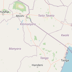
Map view of Tsavo West National Park

Use this park location map to pinpoint Tsavo West National Park in Kenya, understand its exact geographic position, and read its mapped placement within the surrounding landscape more clearly.

Pigeon | © OpenStreetMap contributors

Location context for Tsavo West National Park

Taita-Taveta County
Park atlas

Map connected protected areas, compare diverse landscapes, and trace regional park geography.

Explore National Parks and Protected Areas Near Tsavo West National Park
After exploring Tsavo West National Park, expand your discovery to other national parks and protected areas across the surrounding Kenyan landscape. Compare their unique features, geographic spread, and conservation focuses to gain a deeper understanding of East African protected area networks.
National parkKilimanjaro Region

Kilimanjaro National Park: Protected Landscape Geography and Atlas Exploration

Explore its mapped boundaries and regional context.

Delve into Kilimanjaro National Park, a protected national park situated in the Kilimanjaro Region. This detail page offers an atlas-driven view of the park's geographic scope, focusing on its mapped boundaries and the surrounding natural landscape. Understand the unique terrain and regional context that make this protected area a significant feature within Tanzania's geography.

Area
1,688 km²
Established
1973
IUCN
II
Visitors
52K annual
National parkKenya

Tsavo East National Park: Kenya's Protected Natural Landscape for Geographic Exploration

Explore mapped boundaries and regional park geography.

Tsavo East National Park in Kenya offers a rich entry point for understanding protected landscapes and regional geography. As a designated national park, its mapped boundaries and natural terrain provide essential context for geographic exploration within East Africa. This page serves as a focused discovery point for the park's specific environmental attributes and its role in the broader atlas of protected areas.

Area
13,747 km²
Established
1948
IUCN
II
Relief
Lowland
National parkTanzania

Mkomazi National Park: Tanzania's Vast Protected Savanna Landscape and Wildlife Geography

Explore its mapped terrain and conservation significance within East Africa.

Mkomazi National Park is a critical protected landscape in Tanzania, spanning over 3,200 square kilometers of classic East African semi-arid savanna woodland. This national park offers a unique atlas-style view into conservation success, particularly for its black rhinoceros sanctuary and African wild dog programs. Its landscape is characterized by rolling terrain and Acacia-Commiphora vegetation, forming a vital transboundary conservation area with Kenya that supports significant wildlife migration corridors and provides a distinct geographic context within the broader regional atlas.

Area
3,234 km²
Established
2006
IUCN
II
Visitors
1.6K annual
National parkKenya

Amboseli National Park: Kenya National Park Protected Landscape Atlas

Mapped geographic context and protected area boundaries.

Amboseli National Park is a protected national park in Kenya, offering a distinct geographic entity for exploration. This atlas-focused view details the park's mapped boundaries and regional landscape context. Understand its role as a national park and a significant protected area within the broader geography of Kenya for structured discovery.

Area
392 km²
Established
1974
IUCN
II
Visitors
120K annual
National parkArusha Region

Arusha National Park: A Protected Landscape in Tanzania's Arusha Region

Explore its mapped boundaries and regional geography.

Arusha National Park represents a significant protected landscape within the Arusha Region of Tanzania, offering specific geographic details for atlas-based exploration. This national park's identity is tied to its mapped natural terrain and its position within the broader regional context. Users can delve into the park's protected status and geographic features, making it a valuable entity for understanding the landscape of northern Tanzania.

Area
137 km²
Established
1960
IUCN
II
Visitors
66.8K annual
National parkCoast Province

Arabuko Sokoke National Park: National Park Atlas and Geographic Identity in Coast Province

Mapped protected area within Kenya's coastal region.

Arabuko Sokoke National Park is identified as a protected national park situated within the historical Coast Province of Kenya. This entry offers a focused examination of its protected landscape and geographic significance, contributing to a structured atlas of protected areas. Users can explore the park's mapped boundaries and its positioning within the regional geography, providing essential context for understanding this natural landscape.

Area
6 km²
Established
1990
IUCN
II
Relief
Lowland
Watercolor illustration of a hilly landscape with green and pink hues, showing trees, distant hills, and a light sky
National parkKenya

Kisite-Mpunguti Marine National Park: Kenya's Coastal Protected Marine Landscape

Mapped coral reefs and diverse marine ecosystems.

As Kenya's foremost marine national park, Kisite-Mpunguti Marine National Park presents an unparalleled opportunity to explore a thriving underwater world. Its protected boundaries encompass remarkable coral formations and a rich tapestry of marine species, including diverse fish populations, sea turtles, and dolphins. This park is a cornerstone of coastal conservation, offering valuable insights into marine geography and ecosystem health for those seeking detailed landscape context.

Area
39 km²
Established
1973
IUCN
II
Relief
Lowland
National parkArusha Region

Lake Manyara National Park: Protected Landscape & Rift Valley Geography in Arusha Region

Unique habitats from groundwater forests to alkaline lake shores.

Lake Manyara National Park is a distinct protected landscape situated within the Great Rift Valley of Tanzania's Arusha Region. The park's geography is shaped by the imposing escarpment wall and the alkaline Lake Manyara, creating a mosaic of habitats including rare groundwater forests, acacia woodlands, and saline grasslands. Its unique environment supports diverse wildlife and offers a prime example of regional landscape context and protected area dynamics.

Area
648 km²
Established
1960
IUCN
II
Visitors
178.5K annual

Common questions about visiting, size, designation, and location context for Tsavo West National Park

Tsavo West National Park FAQs for park facts, access, geography, and protected area context
Find quick answers about Tsavo West National Park, including protected-area facts, park geography, trail and visitor context, and how the park fits into its surrounding country and regional landscape.
MoriAtlas Explorer

Continue Your Protected Areas Search Across the Global Atlas

Deepen your exploration by continuing the structured search for national parks and protected areas worldwide. Utilize the comprehensive filtering capabilities to compare different conservation landscapes and refine your understanding of global park geography. Discover more about the distribution and characteristics of protected natural areas.

Global natural geography