

Mori Atlas logo
National parkMonte Alén National Park

Discover the mapped boundaries and regional atlas significance of this national park.

Monte Alén National Park: Protected Landscape and Geographic Context in Equatorial Guinea

Monte Alén National Park represents a significant protected landscape within Equatorial Guinea, offering critical insights into the nation's natural geography. This national park serves as a key entity for atlas-based exploration, allowing users to understand its distinct boundaries and its place within the broader regional context of Central Africa. Explore the geographic identity of Monte Alén National Park and its role as a cornerstone of protected land in the Gulf of Guinea.

Tropical ForestGreat ApesImportant Bird AreaMountain PeaksCentral AfricaRainforest

Monte Alén National Park

National park

Park overview

Structured park overview, official facts, and landscape profile for Monte Alén National Park

Monte Alén National Park park facts, protected area profile, and essential visitor context
Review the core facts for Monte Alén National Park, including designation, size, terrain, visitor scale, habitats, and operating context in one park-focused overview.

About Monte Alén National Park

Monte Alén National Park represents Equatorial Guinea's premier protected natural area and stands as one of Central Africa's most significant conservation landscapes. Located near the geographic center of the country's continental region, the park was officially established in 1990 through presidential decree, though its formal protection status was reinforced in 2000 alongside 13 other protected areas. The park's vast extent of 2,000 square kilometers encompasses a remarkable range of ecosystems, from the lush lowland rainforests of the Uoro River basin to the montane forests clothing the slopes of Monte Alén and Monte Mitra, the nation's highest peaks. The park's boundaries are naturally defined by the Uoro River to the west and the Niefang-Gabon road to the east, while scattered rock outcrops and the forested catchment of Lake Atoc add to the landscape's ecological complexity. The protected area serves as a critical corridor for Central African biodiversity, connecting forest ecosystems across the region and providing essential habitat for species whose survival depends on large, contiguous forest tracts. Trekking paths through the park offer access to its natural wonders while maintaining controlled access to minimize human impact on the sensitive ecosystems.

Quick facts and research context for Monte Alén National Park

Monte Alén National Park covers 2,000 square kilometers in central Equatorial Guinea, making it the country's largest national park. The elevation ranges from 300 to 1,250 meters, supporting both lowland tropical forest and montane ecosystems. The climate is hot and humid equatorial, with average temperatures around 25°C in lower elevations and 20-23°C in the highlands, and annual rainfall between 3,000 and 3,500 millimeters. The park contains 16 primate species, including gorillas and chimpanzees, and protects the world's largest frog species, the goliath frog. Hunting of this endangered amphibian is prohibited within the park boundaries.

Park context

Deeper park guide and search-rich context for Monte Alén National Park

Monte Alén National Park history, landscape, wildlife, and travel context
Explore Monte Alén National Park through its history, landscape character, ecosystems, wildlife, conservation priorities, cultural context, and seasonal travel timing in a structured park guide built for atlas discovery and search intent.

Why Monte Alén National Park stands out

Monte Alén National Park is best known for its exceptional primate populations, particularly the endangered western gorillas and chimpanzees that inhabit its dense forest canopies. The park also protects the goliath frog, the largest frog species in the world, found specifically in the southern regions of the protected area. Its designation as an Important Bird Area highlights the significance of its avifauna, with species such as the grey-necked rockfowl, Zenker's honeyguide, and several endemic warblers contributing to its ornithological importance. The park's dramatic topography, featuring the highest peaks in Equatorial Guinea, offers trekking opportunities through pristine tropical forest environments.

Monte Alén National Park history and protected-area timeline

Monte Alén National Park's formal establishment in 1990 marked a pivotal moment in Equatorial Guinea's conservation history, representing the nation's commitment to preserving its natural heritage. The park's protection status was strengthened in 2000 when presidential decree brought it under the national protected areas framework alongside 13 other designated zones. Prior to formal protection, conservation planning in 1989 focused on zoning forest areas for sustainable logging concessions while encouraging agroforestry activities, reflecting the complex balance between resource utilization and environmental preservation. Subsequent conservation assessments conducted under USAID funding identified hunting of mammals as a critical threat requiring urgent intervention. By 2005, the park's management framework had evolved to prohibit agriculture, hunting, and logging within its boundaries, establishing stronger protective measures for its biodiversity. The park's designation as an Important Bird Area by BirdLife International further cemented its conservation significance at the international level, recognizing the global importance of the species populations it supports.

Monte Alén National Park landscape and geographic character

The physical landscape of Monte Alén National Park is characterized by its dramatic altitudinal variation and diverse terrain within the Central African forest zone. The park encompasses the highest elevations in Equatorial Guinea, with Monte Alén and Monte Mitra rising prominently within its boundaries to create a mountainous core that influences regional climate patterns and ecological zonation. The terrain transitions from the lowland forest zones around 300 meters elevation through successive ecological bands to reach approximately 1,250 meters in the montane areas, where forest composition shifts to accommodate the cooler, more humid conditions. The Uoro River flows along the western boundary of the park, serving as both a geographic edge and an important watercourse supporting downstream ecosystems. The eastern boundary follows the Nearth-Gabon road, while scattered rock outcrops interrupt the predominantly forest-covered landscape, providing microhabitats for specialized species. Lake Atoc, known locally as Lago Atoc, represents a significant freshwater feature whose entire catchment remains under forest cover, maintaining water quality and supporting aquatic biodiversity.

Monte Alén National Park ecosystems, habitats, and plant life

The ecological character of Monte Alén National Park reflects its position within the Guinea-Congo forest block, one of Africa's most biodiverse regions. The park's climate, classified as hot humid equatorial, supports year-round forest productivity with average temperatures ranging from 25°C in the lowlands to 20-23°C in the highland areas, combined with substantial annual rainfall of 3,000-3,500 millimeters. This environmental setting maintains continuous forest cover across the elevational gradient, supporting distinct vegetation communities from lowland evergreen rainforest through montane forest to cloud forest at higher elevations. The forest ecosystem maintains remarkable structural complexity, with多层 canopy layers providing habitat heterogeneity for the diverse species assemblages it supports. Watershed protection, particularly evident in the fully forested catchment of Lake Atoc, demonstrates the park's role in maintaining hydrological processes essential for both wildlife and human communities downstream.

Monte Alén National Park wildlife and species highlights

Monte Alén National Park supports exceptional wildlife diversity, with documented populations of 265 bird species, 105 mammal species, and 65 reptile species, along with numerous amphibians including the globally significant goliath frog. The park's primate community includes 16 species, among them the western gorilla and chimpanzee, whose presence places the park among the most important great ape habitats in Central Africa. Additional primate species include the black colobus, collared mangabey, and mandrill, with the latter forming impressive groups that traverse the forest understory. The mammal fauna extends to both bush elephants and forest elephants, representing distinct ecological forms adapted to different forest habitats, while smaller mammals such as Grasse's shrew complete the mammalian diversity. The avifauna is particularly noteworthy, with the park's Important Bird Area designation reflecting the presence of significant populations of montane species including the grey cuckooshrike, pink-footed puffback, black-capped woodland warbler, and Uganda woodland warbler. The grey-necked rockfowl, Zenker's honeyguide, Tessmann's flycatcher, and Gabon batis represent additional species of conservation concern found within the park. Reptile diversity includes crocodiles, while amphibian conservation is exemplified by species such as Petropedetes palmipes and Leptodactylodon stevarti, both listed on the IUCN Red List, and the goliath frog in the southern portions of the park.

Monte Alén National Park conservation status and protection priorities

Monte Alén National Park holds significant conservation importance as Equatorial Guinea's largest protected area and a critical component of the Central African forest conservation estate. The park's designation as an Important Bird Area by BirdLife International reflects its global significance for biodiversity conservation, particularly for montane bird species with restricted distributions. Conservation challenges have included hunting pressure on mammal populations, which prompted urgent remedial action recommendations from conservation studies. By 2005, the management framework had strengthened to prohibit agriculture, hunting, and logging within the park, establishing robust protective measures. The park's mountain forest ecosystems provide essential habitat for great apes and other threatened species, while its watersheds contribute to broader regional hydrological functions. The prohibition on hunting the goliath frog, the world's largest frog species, demonstrates specific conservation measures protecting the park's unique species. The controlled logging operations within the park boundaries indicate ongoing efforts to balance sustainable resource use with biodiversity protection.

Monte Alén National Park cultural meaning and human context

Monte Alén National Park is situated in the continental region of Equatorial Guinea, an area characterized by its dense tropical forests and relatively limited human population density compared to the country's insular territory. The park's landscape has been shaped by the natural processes of the Central African forest zone rather than extensive historical modification, though local communities have maintained traditional relationships with forest resources. The Spanish colonial heritage of Equatorial Guinea is reflected in the park's official Spanish name, Parque nacional de Monte Alén, which is commonly used alongside the English designation. The park's establishment represents a relatively modern conservation initiative in the context of the nation's independent history, reflecting contemporary priorities for biodiversity preservation and sustainable resource management. The protected area status seeks to maintain the ecological integrity of the forest landscape while providing sustainable benefits for both local communities and the nation as a whole.

Top sights and standout views in Monte Alén National Park

Monte Alén National Park offers visitors access to Equatorial Guinea's most spectacular natural environments, from the montane peaks of Monte Alén and Monte Mitra to the pristine forest surrounding Lake Atoc. The park's primate populations, particularly the habituated gorilla and chimpanzee groups, provide exceptional wildlife viewing opportunities for those exploring its well-laid trekking paths. Bird enthusiasts will find particular value in the park's status as an Important Bird Area, with species such as the grey-necked rockfowl representing highly sought sightings for ornithologists. The presence of the goliath frog, the world's largest amphibian, adds a unique element to the park's wildlife attractions, particularly in the southern sectors where this remarkable species occurs. The dramatic elevational range from 300 to 1,250 meters creates diverse habitats within a single protected area, allowing visitors to experience the transition from lowland rainforest to montane forest environments.

Best time to visit Monte Alén National Park

The hot humid equatorial climate of Monte Alén National Park means that visits can be rewarding throughout the year, though the period from December to February typically offers slightly drier conditions with reduced rainfall. The highland areas remain cooler than the lowlands, providing relief from the consistently warm temperatures that average around 25°C in the lower elevations. The peak wet season from March to November brings heavy rainfall, with annual totals between 3,000 and 3,500 millimeters, which can make some trails more challenging but also contributes to the lush forest environment that defines the park's character. Wildlife viewing may be more productive during the drier months when animals congregate around water sources, though the forest canopy remains dense year-round and guarantees an immersive experience in Central African wilderness.

Park location guide

Geography guide, regional context, and park location map for Monte Alén National Park

Monte Alén National Park park geography, regions, and map view in Equatorial Guinea
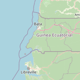
Understand where Monte Alén National Park sits in Equatorial Guinea through a broader geographic reading of the surrounding landscape, nearby location context, and its mapped position within the national park landscape.

How Monte Alén National Park fits into Equatorial Guinea

Equatorial Guinea is a Central African country spanning both mainland territory and islands in the Gulf of Guinea. Formerly the Spanish colony of Spanish Guinea, it gained independence in 1968. The country is characterized by its unique position near the Equator and its significant oil reserves.

Wider geography shaping Monte Alén National Park in Equatorial Guinea

Equatorial Guinea occupies a territory of 28,050 km² on the west coast of Central Africa. The mainland region Río Muni borders Cameroon to the north and Gabon to the south and east. The country includes several islands in the Gulf of Guinea: Bioko Island (the northernmost and site of former capital Malabo), Annobón Island in the south, and smaller islands including Corisco, Elobey Grande, and Elobey Chico. The country lies near the Equator, giving it its name.

Map view of Monte Alén National Park

Use this park location map to pinpoint Monte Alén National Park in Equatorial Guinea, understand its exact geographic position, and read its mapped placement within the surrounding landscape more clearly.

Pigeon | © OpenStreetMap contributors
Park atlas

Explore the Regional Protected Landscapes and Mountainous Terrain of Equatorial Guinea

Discover Other National Parks and Protected Areas Near Monte Alén National Park
Continue your exploration from Monte Alén National Park by browsing other national parks and protected areas across Equatorial Guinea, tracing their mapped geography and unique conservation landscapes. Compare diverse protected regions, from montane forests to lowland rainforests, to understand the broader ecological context of Central Africa's significant natural areas.
National parkWoleu-Ntem Province

Crystal Mountains National Park: National Park Protected Area and Geographic Context in Woleu-Ntem Province

Explore its mapped boundaries and regional landscape.

Crystal Mountains National Park is a designated national park offering critical insights into its protected landscape and geographic setting. Users can explore the mapped boundaries of this protected area, understand its regional terrain, and gain context within Woleu-Ntem Province through structured geographic data. This page provides the foundational atlas information for comprehending the park's conservation significance and natural features.

Area
1,200 km²
Established
2002
IUCN
II
Relief
Mountain
National parkCameroon

Campo Ma'an National Park: Essential Protected Landscape in Cameroon's Atlantic Biafran Forest

Mapped evergreen canopy and vital great ape habitat in a key conservation area.

Campo Ma'an National Park is a crucial protected area in Cameroon, spanning 2,680 square kilometers of dense Atlantic Biafran forest. Established for environmental compensation, it safeguards critical habitat for western lowland gorillas and central chimpanzees, alongside forest elephants and diverse birdlife. The park's landscape is defined by a persistent evergreen canopy ecosystem, offering a unique context for understanding Central African rainforest geography and protected land status.

Area
2,680 km²
Established
2000
IUCN
II
Climate
Tropical
National parkEquatorial Guinea

Altos de Nsork National Park: Equatorial Guinea's Protected Landscape and Map Context

Explore the mapped boundaries of this national park.

Altos de Nsork National Park stands as a designated national park within Equatorial Guinea, offering a distinct protected landscape. This entry provides essential atlas-driven details, emphasizing its geographic setting and mapped park boundaries. Understand its regional context and its significance as part of the conservation network in Central Africa, contributing to a richer understanding of mapped natural terrains.

Area
700 km²
Established
2000
IUCN
II
Relief
Highland
National parkGabon

Pongara National Park: Protected Landscape and Geographic Exploration in Gabon

Mapped boundaries and regional natural context.

Pongara National Park is a designated national park within Gabon, offering a unique opportunity for structured exploration of protected lands. Users can investigate its specific geographic setting, understand its mapped boundaries, and appreciate its place within the regional landscape context. This entry provides a factual foundation for understanding the park's identity as a protected natural area and its contribution to Gabon's geography.

Area
929 km²
Established
2002
IUCN
II
Relief
Lowland
National park

Douala-Edéa National Park: Coastal Mangrove and Tropical Forest Protected Landscape

Explore Cameroon's vital protected national park geography.

Douala-Edéa National Park is a protected national park in Cameroon's Littoral Region, defined by its extensive coastal geography where tropical lowland equatorial forests merge with significant Atlantic mangrove ecosystems. This area, encompassing roughly 2,715 square kilometers along the Bight of Biafra and the Sanaga River estuary, offers rich context for understanding Central Africa's coastal protected lands and diverse natural landscapes.

Area
2,715.12 km²
Established
2018
IUCN
II
Relief
Lowland
National parkBioko Norte

Pico Basilé National Park: Volcanic Peak National Park and Protected Landscape

Explore Bioko Norte's unique montane terrain and rich avifauna.

Pico Basilé National Park is a critical conservation zone encompassing Equatorial Guinea's highest point, Pico Basilé volcano. This national park protects unique montane forest ecosystems and their diverse inhabitants, including several threatened primate species and a significant bird population, making it a key protected area on Bioko Island. Understand its geographic setting within Bioko Norte and its role as a vital natural landscape.

Area
300 km²
Established
2000
IUCN
II
Relief
Mountain
Watercolor painting of a landscape with grassy areas, a lake, and distant hills under a light sky
National parkGabon

Lopé National Park: Gabon's Protected Landscape and National Park Geography

Explore mapped boundaries and natural terrain in Central Africa.

Delve into Lopé National Park, a designated national park situated in Gabon. This protected area serves as a crucial point for understanding the nation's geography and the distribution of its conservation landscapes. As an entry in the MoriAtlas, it offers a detailed view of its mapped territory and its contribution to the broader regional context of Central Africa, emphasizing its role in protected area atlas exploration.

Area
4,910 km²
Established
2002
IUCN
II
Relief
Mixed relief
National parkGabon

Minkébé National Park: Protected Area and Geographic Context in Gabon

Explore the mapped terrain and protected landscape of this national park.

Gain a structured understanding of Minkébé National Park, a designated national park situated in Gabon. This destination focuses on the park's protected landscape, its distinct mapped boundaries, and its contribution to the regional geography of Central Africa. Examine how its protected status shapes the natural terrain and offers a unique angle for geographic discovery.

Area
7,570 km²
Established
2002
IUCN
II
Relief
Upland

Common questions about visiting, size, designation, and location context for Monte Alén National Park

Monte Alén National Park FAQs for park facts, access, geography, and protected area context
Find quick answers about Monte Alén National Park, including protected-area facts, park geography, trail and visitor context, and how the park fits into its surrounding country and regional landscape.
MoriAtlas Explorer

Continue Your Protected Areas Search Across the Global Atlas

Deepen your exploration by continuing the structured search for national parks and protected areas worldwide. Utilize the comprehensive filtering capabilities to compare different conservation landscapes and refine your understanding of global park geography. Discover more about the distribution and characteristics of protected natural areas.

Global natural geography
