

Mori Atlas logo
National parkMount Longonot National Park

Discover the mapped terrain and natural boundaries of this Kenyan National Park.

Mount Longonot National Park: Protected Landscape Atlas and Geographic Context

Mount Longonot National Park represents a significant protected landscape within Kenya, offering a unique geographic entry point for atlas-based exploration. This national park provides a clear focus on mapped boundaries and the surrounding natural terrain, making it an essential component for understanding regional conservation areas. As a key component of Kenya's protected territories, Mount Longonot National Park invites detailed study of its landscape context and geographical features.

volcanic landscapeGreat Rift Valleystratovolcanoprotected areaKenyacrater

Mount Longonot National Park

National park

Park overview

Structured park overview, official facts, and landscape profile for Mount Longonot National Park

Mount Longonot National Park park facts, protected area profile, and essential visitor context

Review the core facts for Mount Longonot National Park, including designation, size, terrain, visitor scale, habitats, and operating context in one park-focused overview.

About Mount Longonot National Park

Mount Longonot National Park is a protected area in Kenya that encompasses the volcanic landscape surrounding Mount Longonot, a dormant stratovolcano located in the Great Rift Valley. The park is situated southeast of Lake Naivasha and forms part of the broader ecosystem of the Rift Valley region. The area is characterized by its dramatic volcanic terrain, including the prominent crater and volcanic ridges that rise from the surrounding plains. The park provides protection to unique highland forest and savanna ecosystems that have developed on the volcanic slopes, creating a distinctive landscape of cultural and ecological significance in Kenya's protected area network.

Quick facts and research context for Mount Longonot National Park

Mount Longonot National Park is located in Nakuru County, Kenya, in the eastern branch of the Great Rift Valley. The protected area surrounds Mount Longonot, a Pleistocene-era stratovolcano that rises approximately 2,770 meters above sea level. The park encompasses the mountain's forested slopes, crater rim, and the transitional savanna zones that connect to the broader Rift Valley landscape. The area lies within a region of significant volcanic activity and forms part of a chain of volcanic features that define the Rift Valley's geography.

Protection and recognition

Exploring the documented terrestrial protection framework and conservation parameters

Mount Longonot National Park Protection Status and Designation

Mount Longonot National Park maintains a documented terrestrial protection status to secure the geographical boundaries of the regional ecosystem. Verified records map the official protection parameters and management scope to offer a clear baseline for regional geographic study.

Protection details

Protection scope
Terrestrial
Park context

Deeper park guide and search-rich context for Mount Longonot National Park

Mount Longonot National Park history, landscape, wildlife, and travel context

Explore Mount Longonot National Park through its history, landscape character, ecosystems, wildlife, conservation priorities, cultural context, and seasonal travel timing in a structured park guide built for atlas discovery and search intent.

Why Mount Longonot National Park stands out

Mount Longonot National Park is best known for its dramatic volcanic scenery and the distinctive crater that marks the summit of the stratovolcano. The mountain's steep forested slopes and the panoramic views from the crater rim across the Rift Valley are particularly notable. The park also protects important highland forest ecosystems that stand in contrast to the surrounding savanna plains, creating a vertical ecological gradient from the lower grasslands to the montane forest zones. Hiking to the crater rim and exploring the volcanic terrain are the primary activities associated with the area.
Monthly climate preview

Long-term temperature and precipitation patterns across the protected landscape

Mount Longonot National Park Climate Normals and Weather by Month

Historical climate records from 1991 to 2020 document the measured annual temperature and precipitation rhythm sampled at a representative coordinate within Mount Longonot National Park. Reviewing the complete monthly profile provides detailed insight into long-term averages without relying on short-term forecasts.
Annual mean17 °C
15 °C19 °C
Jan18°
Feb19°
Mar19°
Apr18°
May16°
Jun15°
Jul15°
Aug15°
Sep17°
Oct17°
Nov17°
Dec17°
Warmest month
February

19 °C

Coolest month
July

14.7 °C

Wettest month
April

5.9 mm/day

Driest month
July

1.6 mm/day

Park location guide

Geography guide, regional context, and park location map for Mount Longonot National Park

Mount Longonot National Park park geography, regions, and map view in Kenya

Understand where Mount Longonot National Park sits in Kenya through a broader geographic reading of the surrounding landscape, nearby location context, and its mapped position within the national park landscape.

How Mount Longonot National Park fits into Kenya

Kenya is a presidential republic in East Africa and the seventh-most populous country on the continent. Its capital is Nairobi, and it borders five countries and the Indian Ocean. The country features significant geographic diversity including Mount Kenya, the Rift Valley, and coastal regions.

Wider geography shaping Mount Longonot National Park in Kenya

Kenya is located in East Africa, bordering South Sudan to the northwest, Ethiopia to the north, Somalia to the east, Tanzania to the southwest, and Uganda and Lake Victoria to the west. The southeastern border meets the Indian Ocean. The geography includes the Rift Valley highlands with Mount Kenya, coastal plains, and northern arid regions.

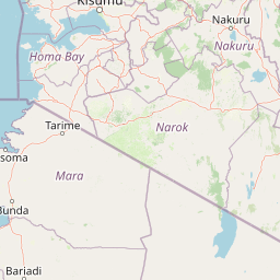
Map view of Mount Longonot National Park

Use this park location map to pinpoint Mount Longonot National Park in Kenya, understand its exact geographic position, and read its mapped placement within the surrounding landscape more clearly.

Pigeon | © OpenStreetMap contributors
Park atlas

Compare Kenya's protected areas across the Great Rift Valley, mapping volcanic and highland forest ecosystems.

Explore Other National Parks and Protected Areas Near Mount Longonot National Park

Continue exploring beyond Mount Longonot National Park by browsing other national parks and protected areas within Kenya's Great Rift Valley region. This geographic view allows for comprehensive comparison of volcanic landscapes, highland forest reserves, and diverse protected areas across the Rift Valley.
National parkNakuru County
About 16 km away#1 closest

West

Hell's Gate National Park: National Park Atlas and Mapped Landscape Exploration

Discover Nakuru County's protected terrain and geographic context.

Explore the mapped boundaries and unique geographic identity of Hell's Gate National Park, a protected national park within Kenya's Nakuru County. This detailed atlas view focuses on the park's natural landscape and its place within the regional geography, offering structured discovery of its protected terrain and surrounding context. Understand the visual and geographic essence of this significant conservation area.

Area
68.25 km²
Established
1984
IUCN
II
Relief
Mountain
National parkKenya
About 59 km away#2 closest

Southeast

Nairobi National Park: Detailed Geographic Overview and Protected Landscape Atlas

Explore the mapped boundaries and regional context of this Kenyan national park.

Nairobi National Park represents a significant protected national park entity within Kenya. This MoriAtlas entry provides detailed insight into its geographic placement and mapped landscape characteristics. Users can delve into the park's specific location, its protected boundaries, and its contribution to the regional geography of East Africa, facilitating structured map-based exploration and understanding of this vital conservation area.

Area
117 km²
Established
1946
IUCN
II
Relief
Mixed relief
National parkKenya
About 61 km away#3 closest

Northwest

Lake Nakuru National Park: An Atlas of Kenyan Rift Valley Protected Landscapes

Geographic boundaries, terrain analysis, and ecosystem context.

Investigate the physical layout and protected status of Lake Nakuru National Park, a critical habitat located within Kenya's Great Rift Valley. This record details the park's alkaline lake basin, surrounding woodland transitions, and its broader role in regional conservation, providing a clear atlas perspective on one of the country's most significant natural protected areas.

Area
188 km²
Established
1961
Relief
Lowland
Climate
Subtropical
National parkNyeri County
About 62 km away#4 closest

Northeast

Aberdare National Park: Mapped Protected Landscape in Nyeri County

National Park Geography and Atlas Context

Aberdare National Park is a protected national park located within Nyeri County, Kenya. This entry offers detailed geographic information and map context, highlighting its protected boundaries and landscape characteristics. Users can explore its regional setting, understand its specific terrain features, and discover its significance as a conservation area within the Kenyan geography. Access structured data that clarifies the park's identity as a vital protected landscape.

Area
767 km²
Established
1950
IUCN
II
Relief
Mountain
National parkRift Valley
About 74 km away#5 closest

Northwest

Lake Nakuru National Park: Geography and Protected Area Atlas Profile for Rift Valley

Mapped soda lake landscapes and rhino sanctuary boundaries

Lake Nakuru National Park is a prominent protected landscape situated in central Kenya, defined by its shallow alkaline lake and surrounding acacia forests. This profile explores the park's geographic footprint, including its role as a fenced sanctuary for rhinoceros and its location within the volcanic Rift Valley system. The terrain provides a clear study in how tectonic structures and water chemistry shape specialized habitats for large mammals and avian populations.

Area
188 km²
Established
1968
IUCN
II
Relief
Mixed relief
National parkKenya
About 90 km away#6 closest

East

Ol Donyo Sabuk National Park: Kenya's Prominent Highland Volcanic Protected Landscape

Mapped National Park boundaries and montane forest geography.

Ol Donyo Sabuk National Park represents a vital protected natural area situated in Kenya's central highlands. Its landscape is dominated by a striking volcanic peak, offering a unique montane forest environment and significant primate habitat. This entry provides essential details for atlas exploration, focusing on the park's geographic placement, its protected landscape features, and the ecological context it represents within Kenya's protected areas system.

IUCN
II
Relief
Mountain
Scope
Terrestrial
Water
Minor water
National parkKenya
About 131 km away#7 closest

Northeast

Mount Kenya National Park: Mapped Volcanic Landscape & Protected Area Geography

Kenya's high-altitude Afro-alpine ecosystems and mapped park boundaries.

Mount Kenya National Park safeguards a globally significant volcanic landscape and vital water resources for Kenya. This protected area above 3,000 meters features dramatic peaks, glaciers, and distinctive Afro-alpine flora. Explore its comprehensive mapped boundaries, understand its regional geographic importance, and discover the unique ecosystems that define this exceptional national park through detailed atlas context.

Area
715 km²
Established
1949
IUCN
II
Relief
Mountain
National parkMara Region
About 158 km away#8 closest

Southwest

Serengeti National Park: National Park Atlas and Protected Landscape Discovery

Explore savanna grasslands, regional geography, and mapped park boundaries.

Serengeti National Park, a significant national park within Tanzania's Mara Region, offers an unparalleled view into a vast protected landscape. This page provides access to the park's geographic identity, its defining savanna ecosystem, and its role as a critical component of the regional atlas. Understand the mapped extent of its protected boundaries and the unique natural context that supports its renowned wildlife.

Area
14,763 km²
Established
1940
IUCN
II
Visitors
350K annual

Common questions about visiting, size, designation, and location context for Mount Longonot National Park

Mount Longonot National Park FAQs for park facts, access, geography, and protected area context

Find quick answers about Mount Longonot National Park, including protected-area facts, park geography, trail and visitor context, and how the park fits into its surrounding country and regional landscape.
MoriAtlas Explorer

Continue Your Protected Areas Search Across the Global Atlas

Deepen your exploration by continuing the structured search for national parks and protected areas worldwide. Utilize the comprehensive filtering capabilities to compare different conservation landscapes and refine your understanding of global park geography. Discover more about the distribution and characteristics of protected natural areas.

Global natural geography
