
Rivers
Park geography
A detailed examination of environmental zones, arid landscapes, and coastal extents.
Geographic Profile and Mapped Boundaries of Namib-Naukluft National Park in Namibia
Examine the physical geography of Namib-Naukluft National Park, covering an expansive area of 49,768 square kilometers across Namibia. This structured profile details the park's desert, mountain, and coastal terrain, providing insights into its diverse habitat types, major water presence, and arid climate conditions.
Related tags
desert landscapesand dunescoastal parkmountain terrainwildlife conservation
Vast desert wilderness of ancient dunes and towering mountains in Namibia
Namib-Naukluft National Park
Namib-Naukluft National Park is a massive protected area in western Namibia, spanning approximately 49,768 square kilometers along the Atlantic Ocean coast between the river mouths of the Swakop and Kuiseb. The park encompasses the iconic Namib Desert, widely considered the world's oldest desert, as well as the rugged Naukluft mountain range and the ecologically significant lagoon at Sandwich Harbour. This transect from ocean to inland escarpment creates a remarkable gradient of landscapes, from coastal fog zones and marine environments through towering sand dunes to mountainous terrain. The park holds the distinction of being the largest game park in Africa and the fourth largest national park in the world. Its most celebrated area is Sossusvlei, a striking clay pan surrounded by some of the highest sand dunes on Earth, accessible via the gateway settlement of Sesriem. The park also contains the Gobabeb desert research station, a center for scientific study of desert ecosystems.
- Location
- Namibia
- Park type
- National park
- Established
- 1907
- Area
- 49,768 km²
Location overview
Mapping the coastal and marine boundaries within the Namibian nation
Geographic Position of Namib-Naukluft National Park in Namibia
Namib-Naukluft National Park represents a significant protected area positioned entirely within Namibia. Records confirm both coastal and marine classifications for the sanctuary, shaping its regional status.
- Countries
- Namibia
- Primary location
- Namibia
- Geographic setting
- Coastal · Marine
Boundary and coordinates
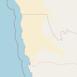
Namib-Naukluft’s desert-park outline spans 49,768 km²
Namib-Naukluft National Park mapped boundary and 49,768 km² area
Namib-Naukluft National Park’s mapped footprint spans an immense recorded 49,768 km². The geometry powerfully conveys scale at atlas level while leaving formal legal limits to authoritative sources.
- Boundary area
- 50,762.6 km²
- Boundary perimeter
- 1,597.7 km
- Northernmost point
- 22.5129° S
- Southernmost point
- 26.7075° S
- Easternmost point
- 16.4234° E
- Westernmost point
- 14.433° E
- Geographic centre
- 24.5461° S, 15.3297° E
- North–south span
- 464.6 km
- East–west span
- 201.6 km
Terrain and natural features
Explore recorded peaks, rivers, capes, and springs within the protected area.
Namib-Naukluft National Park Terrain and Named Natural Features
Mixed relief and mountain park classifications define the terrain across this protected landscape alongside recorded named features like rivers, peaks, and springs. Linked feature cards supply names, types, measurements, and spatial relationships where documented.
Selected named natural features
Capes
North Point
Peaks
Bushman Hill
1,690 m
Capes
Easter Point
Streams
Ururas
Peaks
Nos Numabis
Environmental setting
Arid climate zones, mixed relief types, and diverse desert habitat categories
Namib-Naukluft National Park Environmental Classifications and Physical Settings
Stored landscape features and habitat types frame the physical setting of Namib-Naukluft National Park through broad interpretive categories. Recorded classifications connect directly to related atlas destinations across the protected area.
- Relief
- Mixed relief
- Climate
- Arid
- Water
- Major water bodies
- Forest cover
- Sparse forest
- Seasonality
- Seasonal
Landscape features
Mountains · Valleys · Plateau · Cliffs · Canyon · Forest · Grassland · Wetland · Lakes · Rivers · Coast · Beach · Dunes · Desert
Habitat types
Desert habitat · Dune habitat · Coastal habitat · Marine habitat · Wetland · Riverine habitat · Grassland
Park atlas
Compare Namibia's Protected Areas, Tracing Diverse Desert, Mountain, and Coastal Geographies
Explore Related National Parks and Protected Landscapes Near Namib-Naukluft National Park
After exploring Namib-Naukluft National Park, browse other protected areas within Namibia and its surrounding regions. Continue your atlas-style park discovery by mapping diverse landscapes, from coastal desert zones to rugged mountain ranges, comparing their unique conservation profiles and geographic features.
National parkNamibia
Park boundaries overlap#1 closest
Northwest

Dorob National Park: Namibia's Expansive Coastal Desert and Protected Bird Habitat
Explore mapped landscapes and regional geography.
Dorob National Park is a prime example of a protected coastal desert landscape, stretching along Namibia's Atlantic coast. This national park is renowned for its significant bird populations, making it an Important Bird Area with extensive mapped habitats supporting diverse species. Understand the park's geographic context, from its dramatic dunes to its ephemeral river systems, and its role as a key conservation area within the region.
- Area
- 107,540 km²
- Established
- 2010
- IUCN
- II
- Relief
- Lowland
Nature reserveNamibia
About 15 km away#2 closest
Southeast
Tirasberge Nature Reserve: Geography and Protected Landscapes of Southern Namibia
A compact wilderness spanning mountain massifs and desert frontiers.
The Tirasberge region serves as a vital protected area in southern Namibia, showcasing a diverse intersection of mountain ridges, red sand dunes, and arid savanna plains. This reserve provides a unique look into a stratified landscape where high elevation terrain meets the lower reaches of the Namib dune sea, creating a complex corridor for ecology and history. Understanding the reserve reveals how mountain-to-savanna transitions define the rugged character of this southern African conservation zone.
- Area
- 1,250 km²
- Established
- 1998
- Relief
- Mountain
- Climate
- Arid
National parkNamibia
About 26 km away#3 closest
South
Tsau ǁKhaeb National Park: Namibia's Protected Area and Geographic Identity
Mapped natural landscape and park boundaries in Namibia.
Tsau ǁKhaeb National Park represents a vital protected area within Namibia, offering deep insights into the country's unique arid environments. This park detail page serves as an atlas entry focused on its mapped geography, highlighting its protected boundaries and its role within the broader landscape of Southern Africa. Explore the inherent geographic characteristics and conservation significance of this national park.
Marine protected areaNamibia
About 27 km away#4 closest
South
Meob-Chamais Islands’ Marine Protected Area: Mapped Coastal and Marine Sanctuary
A protected Atlantic marine region in coastal Namibia
Spanning from Meob Bay to Chamais Bay, this expansive marine protected area preserves the vital intersection between Namibia's arid desert shoreline and the cold, productive waters of the Atlantic. The region comprises ten primary islands and numerous islets that provide essential breeding platforms for bank cormorants and African penguins. This site remains a foundational element of regional coastal conservation and marine geography.
- Area
- 20,000 km²
- Established
- 2009
- IUCN
- VI
- Scope
- Marine
Protected areaNamibia
About 128 km away#5 closest
Northeast
Gross Barmen Protected Area: Landscape Geography and Thermal Spring Mapping in Namibia
Central Namibia thermal spring and historic natural monument
Gross Barmen is a state-managed recreation area in central Namibia, centered on a natural sulfurous spring that emerges within a flat thornveld landscape. This protected area acts as both a cultural heritage site and a geological feature, providing a clear window into the regional terrain of the Otjozondjupa area through its thermal waters and historical mission foundations.
- Area
- 1 km²
- Established
- 1968
- Relief
- Lowland
- Climate
- Arid
Nature reserveWindhoek
About 142 km away#6 closest
Northeast
Südwest-Naturreservat: A Protected Botanical Nature Reserve in Central Windhoek
Conservation landscapes and native flora in the Khomas Highland
Located in central Windhoek, Südwest-Naturreservat functions as a key protected area and botanical site. It showcases a diverse collection of Namibian plants across both landscaped and natural terrain, offering a focused look at arid and semi-arid flora within an accessible urban environment that highlights the region's unique biodiversity.
- Area
- 0.12 km²
- Established
- 1970
- IUCN
- V
- Relief
- Upland
Protected landscapeOtjozondjupa
About 153 km away#7 closest
Northeast
Von-Bach-Erholungsgebiet: A Protected Landscape of Dam Waters and Bushveld Terrain
Geographic overview of the Otjozondjupa recreation reserve.
The Von-Bach-Erholungsgebiet landscape defines a unique intersection between the northern Eros Mountain foothills and the Von-Bach Dam reservoir. Characterized by khaki bushveld, scattered acacia, and rolling ridges, this protected area serves as a primary hub for water-based recreation and bushland exploration in central Namibia.
- Area
- 43 km²
- Established
- 1972
- IUCN
- V
- Relief
- Upland
National parkNorthern Cape
175 km away#8 closest
South

Richtersveld National Park: Geographic and Protected Area Map Context
Exploring arid volcanic landscapes in Northern Cape
Richtersveld National Park represents a vast, complex protected area defined by its rugged mountain ridges and arid desert ecology. Centered in South Africa's Northern Cape, the landscape is shaped by the Orange River and high-altitude volcanic formations. This profile offers detailed insight into the park's natural boundaries, endemic plant habitats, and its role as a living cultural landscape within the wider regional geography.
- Area
- 1,624.45 km²
- Established
- 1991
- Relief
- Mountain
- Climate
- Arid
MoriAtlas Explorer
Continue Exploring Namib-Naukluft National Park's Geographic and Landscape Context
Deepen your understanding of Namib-Naukluft National Park's extraordinary protected landscape and its place in the regional geography of Namibia. By examining its mapped features and unique terrain, you can grasp the full scope of this ancient desert environment and its conservation significance. Explore the detailed geographic context that defines this immense national park and its distinctive natural features.
Browse next
Global natural geography
Explore related park routes
Explore MoriAtlas Global ParksBrowse All MoriAtlas ParksGlobal Park Map DiscoveryMoriAtlas: Browse All CountriesBrowse All MoriAtlas ContinentsNational Park Environment AtlasGrand Canyon National Park AtlasYellowstone National Park AtlasYosemite National Park Atlas and GeographySerengeti National Park AtlasGalápagos National Park Protected LandscapeBanff National Park Geography and AtlasKruger National Park Atlas EntryUluṟu-Kata Tjuṯa National Park AtlasExplore Uluru-Kata Tjuta National Park GeographyPlitvice Lakes National Park AtlasFiordland National Park Protected LandscapeGreat Smoky Mountains National Park AtlasAfghanistan National Parks and Protected AreasAlbania National Parks and Protected AreasAlgeria National Parks and Protected AreasAmerican Samoa National Parks and Protected AreasAndorra National Parks and Protected AreasAngola National Parks and Protected AreasAntarctica National Parks and Protected AreasAntigua and Barbuda Park List