Mori Atlas logo
National parkNational Park of Upper Niger

Mapping the savanna ecosystems and riparian forest corridors of the Upper Niger River basin

National Park of Upper Niger: Examining the Protected Landscape and Geography of Guinea

(Parc National du Haut Niger)

The National Park of Upper Niger represents a critical conservation landscape within the Faranah Region of Guinea. As the largest protected area in the country, the park encompasses approximately 6,000 square kilometers of savanna woodland and the rare Mafou dry forest. This geography provides vital habitat for diverse mammal species along the Niger River and its tributaries, forming a model for integrated land management in West Africa.

national parksavanna ecosystemdry forestriparian forestWest Africalion conservation

National Park of Upper Niger

National park

Park overview

Structured park overview, official facts, and landscape profile for National Park of Upper Niger

National Park of Upper Niger park facts, protected area profile, and essential visitor context

Review the core facts for National Park of Upper Niger, including designation, size, terrain, visitor scale, habitats, and operating context in one park-focused overview.

About National Park of Upper Niger

The National Park of Upper Niger occupies a unique position in Guinea's protected area network as the country's largest national park and one of the most ecologically significant conservation landscapes in the Upper Niger basin. Located in the Faranah Region of eastern Guinea, the park was officially gazetted in January 1997, establishing formal protection for a landscape that had remained relatively undisturbed due to historical factors including low population density and limited agricultural development. The park's ecological significance extends far beyond Guinea's borders, representing a conservation priority for West Africa as a whole due to the rarity of remaining natural habitats in this region. The park protects a heterogeneous landscape combining extensive savanna woodland and bushland with critical riparian forest corridors along the Niger and Mafou Rivers. The Mafou Forest component is particularly important, representing the last substantial tract of dry forest remaining in Guinea and one of the few examples of this forest type still standing in West Africa. This forest persisted historically because the region experienced low human activity due to the prevalence of river-blindness (onchocerciasis) and the historical activities of Samory Touré during the late nineteenth century, both of which discouraged permanent settlement and intensive land use. The park's management follows a zonation approach, with a strictly protected core area and a surrounding buffer zone where local communities are permitted sustainable use of natural resources including non-timber forest products, fishing, and limited agricultural activity.

Quick facts and research context for National Park of Upper Niger

The National Park of Upper Niger spans the upper Niger River basin in Guinea's Faranah Region, protecting a mosaic of savanna woodland, bushland, and riparian forest habitats. Gazetted in 1997, the park covers roughly 6,000 square kilometers with a core protected area of 554 square kilometers. The ecosystem is characterized by dominant savanna vegetation with riparian corridors along the Niger and Mafou Rivers, and approximately five percent of the land is under agricultural use along park boundaries. The park is managed as a dual-zone system, with a strictly protected core area and a surrounding buffer zone where sustainable resource use by local communities is permitted. The protected area was designated as a Lion Conservation Unit in 2005, reflecting its importance for large carnivore populations in West Africa.

Protection and recognition

Documented terrestrial protection history and conservation framework data

National Park of Upper Niger Protection Status and Designated History

National Park of Upper Niger maintains a documented terrestrial protection status established in 1997 within the global database. Official records outline the formal designation timeline, management scope, and verified registry attributes.

Protection details

Protection scope
Terrestrial
Designated year
1997
Transboundary protection
No
WDPA ID
28035065
Core area
554 km²
Buffer area
5,446 km²
Park context

Deeper park guide and search-rich context for National Park of Upper Niger

National Park of Upper Niger history, landscape, wildlife, and travel context

Explore National Park of Upper Niger through its history, landscape character, ecosystems, wildlife, conservation priorities, cultural context, and seasonal travel timing in a structured park guide built for atlas discovery and search intent.

Why National Park of Upper Niger stands out

The National Park of Upper Niger is best known for protecting the Mafou Forest, which represents the last significant remnant of dry forest in Guinea and one of the few surviving examples of this endangered forest type across West Africa. The park is also recognized as a critical conservation area for West African lion populations, having been designated a Lion Conservation Unit in 2005. The diverse mammalian fauna documented within the park includes 94 species, representing exceptional biodiversity for a savanna-protected area. The park's significance is further enhanced by its position along the Niger River, whose riparian forests provide critical habitat for species adapted to water-associated ecosystems. The park's dual-zone management approach, combining strict protection with sustainable community use in buffer areas, represents a model for integrated conservation in the region.
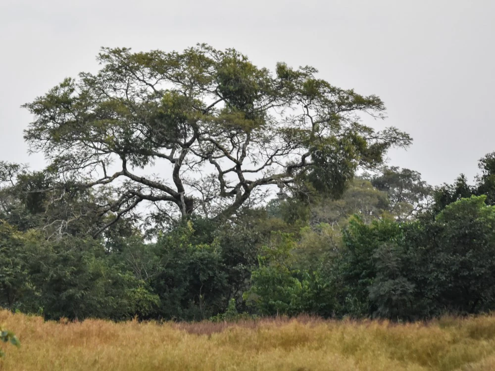
Large tree with sprawling branches in a grassy savanna landscape with dense vegetation in the background under an overcast sky
Savanna woodland landscape in National Park of Upper Niger

National Park of Upper Niger history and protected-area timeline

The establishment of the National Park of Upper Niger in 1997 represented the culmination of growing recognition that areas of relatively low human impact had become increasingly rare within Guinea's borders. The park's current territory encompasses what was historically one of the few remaining areas with limited human disturbance, a condition attributable to specific historical circumstances that discouraged settlement and intensive land use. The Mafou Forest area within the park has particular historical significance, having remained one of Guinea's least disturbed forest areas for more than half a century. The region's low population density resulted from two primary factors: the widespread prevalence of river-blindness (onchocerciasis), a debilitating parasitic disease transmitted by black flies that thrives along river systems, and the military activities of Samory Touré, the nineteenth-century leader who conducted resistance campaigns against French colonial forces in the region during the 1880s and 1890s. Following independence, the area remained relatively untouched due to its remoteness and challenging conditions. The formal establishment of the park in 1997 created a framework for systematic conservation management, with the park designated as a Lion Conservation Unit in 2005, acknowledging its importance for protecting viable populations of this iconic large carnivore. The management approach incorporates community-based conservation, involving local populations in sustainable resource use while maintaining protection for core conservation areas.

National Park of Upper Niger landscape and geographic character

The National Park of Upper Niger presents a varied landscape character defined by the interplay of savanna ecosystems and riparian forest systems within the upper Niger River basin. The dominant terrain consists of savanna woodland and bushland, representing the characteristic vegetation of the Guinea savanna zone that extends across much of West Africa's interior. This savanna landscape is punctuated by the riparian forests that follow the Niger River and its tributary, the Mafou River, creating linear corridors of denser forest that contrast sharply with the surrounding open woodland. The riparian forests along these watercourses represent critical habitat islands within the broader savanna matrix, providing shade, moisture, and specialized habitats for species associated with water and forest edge environments. The landscape includes areas of agricultural use concentrated along the park's edges, representing approximately five percent of the total area where farming occurs within the broader savanna mosaic. The terrain experiences seasonal dynamics associated with the West African dry season, when fires naturally sweep through the savanna and shape the structure and composition of the vegetation. The park's position in the upper Niger basin places it at a critical hydrological location, with the river and its tributaries providing water resources that sustain both wildlife and local communities throughout the year.

National Park of Upper Niger ecosystems, habitats, and plant life

The National Park of Upper Niger protects a remarkable diversity of ecological zones and habitat types within a relatively compact protected area. The dominant ecosystem is savanna, characterized by woodland and bushland formations that support a characteristic West African fauna adapted to open grassy environments with scattered trees and shrubs. The riparian forests along the Niger and Mafou Rivers represent a distinct habitat type, providing more closed canopy conditions and access to water resources that support species requiring forest cover or aquatic environments. These riverine corridors serve as vital refuges and movement pathways for wildlife throughout the park. The park contains the Mafou Forest, which represents the last significant example of dry forest in Guinea and one of the few remaining dry forest tracts in all of West Africa, making it an ecosystem type of regional conservation priority. The park's position at the intersection of multiple ecological zones contributes to its biodiversity significance, with species from both forest and savanna biomes present within its boundaries. The seasonal fire regime that characterizes the savanna during dry seasons shapes vegetation dynamics and creates the open grassland conditions that maintain the savanna ecosystem character.

National Park of Upper Niger wildlife and species highlights

The National Park of Upper Niger supports an exceptional mammalian fauna, with surveys documenting 94 species within the protected area. The mammal community includes representatives from multiple taxonomic groups: 24 rodent species, 18 bat species including Franquet's epauletted fruit bat and horseshoe bat, 17 carnivore species such as caracal, Egyptian mongoose, Gambian mongoose, and spot-necked otter, 14 ungulate species including giant forest hog, kob, and waterbuck, nine insectivore species including four-toed hedgehog and climbing shrew, and seven primate species including common chimpanzee and Senegal galago. The park is particularly notable for its large carnivore populations, with African lion recorded returning to the protected area in 1997, likely migrating from the Tinkisso River region, leading to the park's designation as a Lion Conservation Unit in 2005. Other significant species include giant pangolin and tree pangolin, and the African manatee has been recorded in the park's waterways. Historically, African elephants inhabited the park but are now locally extinct. The diverse primate community, particularly the presence of chimpanzees, indicates the park's importance for forest-dwelling species within the broader savanna landscape.

National Park of Upper Niger conservation status and protection priorities

The National Park of Upper Niger represents a conservation priority of international significance for West Africa, protecting habitats that have become increasingly rare across the region. The park's designation as a Lion Conservation Unit in 2005 underscores its importance for safeguarding viable populations of the West African lion subspecies, which is considered endangered and occurs in only a handful of protected areas across the region. The protection of the Mafou Forest is particularly significant, as this represents one of the last remaining tracts of dry forest in Guinea and one of the few surviving examples of this forest type in West Africa, making the park critical for conserving this endangered ecosystem. The management approach combines strict protection of core areas with sustainable use zones that engage local communities in conservation, recognizing that long-term protection requires addressing the needs and livelihoods of people living in and around the protected area. The dual-zone system permits sustainable farming, collection of non-timber forest products, fishing, and limited hunting and timber harvesting within the buffer zone while maintaining strict protection in the core area. Community-based management of natural resources represents a pragmatic approach to conservation that addresses the challenge of protecting biodiversity in a region where human populations depend on natural resources for livelihoods.

National Park of Upper Niger cultural meaning and human context

The landscape within the National Park of Upper Niger has been shaped by historical processes that created conditions favorable for conservation by limiting human impact. The Mafou Forest area within the park remained relatively undisturbed partly due to historical events that discouraged settlement, including the prevalence of river-blindness (onchocerciasis), a disease that has historically limited human settlement along West African river systems. Additionally, the region was affected by the military campaigns of Samory Touré during the late nineteenth century, whose resistance against French colonial expansion created instability that further limited population growth and agricultural development in the area. These historical factors resulted in the persistence of natural ecosystems that have been largely converted to agriculture or degraded across much of Guinea and surrounding countries. The park's buffer zone management approach recognizes the ongoing presence of local communities and their reliance on natural resources, incorporating sustainable use practices that allow traditional livelihoods to continue while protecting core conservation areas.

Top sights and standout views in National Park of Upper Niger

The National Park of Upper Niger stands as Guinea's flagship protected area and a critical conservation landscape for West Africa. The park protects the last significant dry forest in Guinea through the Mafou Forest, an ecosystem of regional priority that represents one of few remaining examples of this endangered forest type in West Africa. The return of lions to the protected area in 1997 and subsequent designation as a Lion Conservation Unit in 2005 highlights the park's importance for large carnivore conservation. With 94 documented mammal species, the park supports exceptional biodiversity across its savanna, woodland, and riparian forest habitats. The park's dual-zone management approach demonstrates integrated conservation that combines strict protection with sustainable community use, providing a model for balancing biodiversity conservation with human livelihood needs in the Upper Niger region.

Best time to visit National Park of Upper Niger

The optimal time to visit the National Park of Upper Niger corresponds with the dry season, which typically runs from November through April. During this period, reduced vegetation density improves wildlife visibility as animals concentrate around remaining water sources along the Niger River and its tributaries. The landscape character shifts during the dry season, with shorter grass and more open savanna conditions that facilitate game viewing and park exploration. However, visitors should be aware that the park experiences frequent natural fires during the dry season, which are a normal part of the savanna ecosystem dynamics but may affect visibility and accessibility. The wet season from May through October transforms the landscape with lush vegetation and flowing watercourses but may present challenges for park access and wildlife viewing as animals disperse more widely across the expanded landscape.
Monthly climate preview

Long-term representative monthly averages for temperature and precipitation

National Park of Upper Niger Climate Normals and Annual Temperature Patterns

Representative coordinates record measured monthly temperature and precipitation cycles across the conservation landscape. Examining the full twelve-month profile provides complete historical averages for detailed climate analysis.
Annual mean26 °C
23 °C30 °C
Jan24°
Feb27°
Mar29°
Apr30°
May28°
Jun27°
Jul25°
Aug24°
Sep24°
Oct25°
Nov24°
Dec23°
Warmest month
April

30 °C

Coolest month
December

23.4 °C

Wettest month
August

11.8 mm/day

Driest month
December

0.1 mm/day

Park location guide

Geography guide, regional context, and park location map for National Park of Upper Niger

National Park of Upper Niger park geography, regions, and map view in Guinea

Understand where National Park of Upper Niger sits in Guinea through a broader geographic reading of the surrounding landscape, nearby location context, and its mapped position within the national park landscape.

How National Park of Upper Niger fits into Guinea

Guinea is a West African country with a population of approximately 14 million people. The country achieved independence from France in 1958 and is known for its diverse geography ranging from coastal lowlands to highland plateaus. Conakry serves as both the capital and largest city. Guinea is a member of the United Nations, ECOWAS, the African Union, and La Francophonie.

Wider geography shaping National Park of Upper Niger in Guinea

Guinea is located on the West African Atlantic coast, bordered by Guinea-Bissau to the northwest, Senegal to the north, Mali to the northeast, Ivory Coast to the southeast, and Sierra Leone and Liberia to the south. The country is divided into four geographic regions: Maritime Guinea along the Atlantic coast, the Fouta Djallon highlands in Middle Guinea, the Upper Guinea savanna in the northeast, and the forested Guinea region in the southeast.

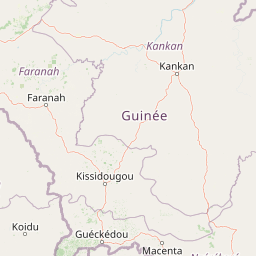
Map view of National Park of Upper Niger

Use this park location map to pinpoint National Park of Upper Niger in Guinea, understand its exact geographic position, and read its mapped placement within the surrounding landscape more clearly.

Pigeon | © OpenStreetMap contributors

Visual reference of Guinea savanna, riparian corridors, and dry forest habitats

National Park of Upper Niger Photos and Landscape Scenery

National Park of Upper Niger photography reveals the intricate mix of open woodland, riverine corridors, and protected dry forest. Examining these natural environments provides deeper insight into the protected landscape and the diverse habitats sustaining regional wildlife.

Large tree with sprawling branches in a grassy savanna landscape with dense vegetation in the background under an overcast sky

Park atlas

Compare adjacent savanna ecosystems and regional conservation landscapes

Explore National Park of Upper Niger and Nearby Protected Areas

Discover protected areas near National Park of Upper Niger by comparing adjacent savanna woodland and riparian forest habitats. Examining surrounding conservation regions provides deeper geographic context for the upper Niger River basin.
National parkFaranah Region
Mapped park locations coincide#1 closest

National Park of Upper Niger: Mapped Savanna and Forest Protected Area in Faranah Region

A key West African conservation site with critical riparian corridors.

Spanning 6,000 square kilometers, the National Park of Upper Niger serves as a primary reservoir for biodiversity in Guinea. The park features a distinct transition between open woodland savanna and forested river corridors along the Niger and Mafou Rivers. It remains a significant model for community-led conservation and habitat preservation in West Africa, representing one of the region's few areas with relatively low human impact.

Area
6,000 km²
Established
1997
IUCN
II
Relief
Mixed relief
National parkKankan Region
About 5.5 km away#2 closest

Southwest

Parc national du Haut-Niger: Protected Area Map and Geographic Landscape Profile

West African dry forest and savanna conservation zone

Parc national du Haut-Niger represents a significant conservation unit in the Kankan Region of Guinea. This protected area safeguards one of the last major stands of dry tropical forest in the region, offering a rich study in riverine geography and savanna ecology along the upper Niger River and its major tributaries.

Area
554 km²
Established
1997
IUCN
II
Relief
Mixed relief
Nature reserveIvory Coast
About 165 km away#3 closest

West

Forêt classée de Pinselly: Protected Area Geography and Landscape Mapping

Nature reserve analysis and regional atlas context

Examine the formal boundaries and landscape character of Forêt classée de Pinselly. This atlas entry focuses on the geographic structure and environmental positioning of this nature reserve in Ivory Coast, offering a clear view of its role as a protected landscape.

Established
1945
Relief
Mountain
Climate
Tropical
Access
Moderate access
Protected areaMamou Region
About 188 km away#4 closest

West

Bafing-Source Protected Area: A Highland Wetland Landscape in the Mamou Region

Tracing the headwaters and plateau geography of the Bafing River basin

The Bafing-Source protected area serves as a significant hydrological anchor within the Fouta Djallon highlands of Guinea. This expansive site protects critical wetland catchments and plateau terrain that feed into the broader Senegal River system, demonstrating the vital link between highland ecosystems and downstream water security.

Area
3,172 km²
Established
2007
Relief
Highland
Climate
Tropical
National parkKarene District
About 216 km away#5 closest

West

Outamba-Kilimi National Park: Sierra Leone National Park and Protected Landscape Atlas

Mapped natural terrain within Karene District.

Investigate Outamba-Kilimi National Park as a protected area, examining its geographic footprint and significance within Sierra Leone's natural landscapes. This detailed entry provides context on the park's mapped boundaries and its contribution to regional geography, serving as a key point for atlas-based exploration of conservation lands in the Karene District.

Area
1,109 km²
Established
1986
IUCN
II
Relief
Lowland
National parkMali
About 259 km away#6 closest

North

Kouroufing National Park: Mali's National Park with Defined Protected Landscape Boundaries

Explore the mapped geography and protected land context of Kouroufing National Park.

Kouroufing National Park is a significant protected area recognized as a national park within Mali. This entry focuses on its distinct geographic identity and mapped boundaries, essential for understanding its role in the regional atlas. Examine the park's protected landscape context and how it contributes to the natural geography of West Africa. This resource is tailored for users seeking detailed information on specific protected areas rather than broad travel advice.

Area
557 km²
Established
2002
Scope
Terrestrial
Water
No major water
Biosphere reserveNzerekore Region
About 262 km away#7 closest

South

Massif de Ziama Biosphere Reserve: Geographic Overview and Protected Forest Boundaries

A montane forest complex in the Nzerekore Region of Guinea.

Massif de Ziama functions as a significant forested mountain chain and protected biosphere reserve in the Nzerekore Region. This geographic profile details the massif's high-elevation terrain, its connectivity with the Kpo Range in Liberia, and its foundational importance as a remnant of the Upper Guinean forest formation.

Established
1980
Protected areaGuinea
About 265 km away#8 closest

Northeast

Sankarani River Protected Area: Guinea Highland Watershed and River Basin Geography

Mapping riparian corridors and Ramsar wetland ecosystems

The Sankarani River represents a vital hydrologic system originating in the Guinea Highlands. As a designated Ramsar site, this protected area features a unique 170-kilometre floodplain, gallery forest ribbons, and iron-bearing terrain. Map the riverine path and understand the environmental significance of this major tributary within the upper Niger Basin and the Fouta Djallon landscape.

Established
2002
Relief
Mixed relief
Scope
Terrestrial
Water
Major water bodies

Common questions about visiting, size, designation, and location context for National Park of Upper Niger

National Park of Upper Niger FAQs for park facts, access, geography, and protected area context

Find quick answers about National Park of Upper Niger, including protected-area facts, park geography, trail and visitor context, and how the park fits into its surrounding country and regional landscape.
MoriAtlas Explorer

Continue Your Protected Areas Search Across the Global Atlas

Deepen your exploration by continuing the structured search for national parks and protected areas worldwide. Utilize the comprehensive filtering capabilities to compare different conservation landscapes and refine your understanding of global park geography. Discover more about the distribution and characteristics of protected natural areas.

Global natural geography