Mori Atlas logo
Protected areaSankarani River

Tracing the Fouta Djallon headwaters, floodplain corridors, and international watershed boundaries.

Sankarani River Protected Area: Geographic Context of Guinea's Major Riverine Landscape

(Sankarani-Fié (Ramsar designation))

The Sankarani River originates in the rugged Fouta Djallon highlands of Guinea, forming a complex watershed that serves as a critical tributary to the Niger River. This protected wetland system encompasses expansive floodplains and dense gallery forests that support regional ecology across international borders. Discover the physical geography and riverine landscape patterns that define this significant West African water system within the broader Niger Basin.

West Africatributary riverNiger River basinFouta Djallonfloodplaingallery forest

Sankarani River

Protected area

Park overview

Structured park overview, official facts, and landscape profile for Sankarani River

Sankarani River park facts, protected area profile, and essential visitor context

Review the core facts for Sankarani River, including designation, size, terrain, visitor scale, habitats, and operating context in one park-focused overview.

About Sankarani River

The Sankarani River is one of the defining waterways of the upper Niger basin in West Africa. Rising in the Guinea Highlands of the Fouta Djallon, it follows a generally northward course, carving through landscapes that transition from the high-altitude plateaus of Guinea into the broader floodplains and plains of southern Mali. As it nears Bamako, the river merges with the Niger, contributing to the flow of one of Africa's longest and most historically significant river systems.

In addition to its hydrological importance, the Sankarani has played a practical role in regional development. The watershed, traditionally rich in agricultural potential and deposits of iron and gold, has supported farming and other livelihoods across generations. In Mali, the river was harnessed through the construction of the Sélingué Dam, completed in the early 1980s, which at the time of its inauguration represented the largest development project in Malian history. The dam introduced hydroelectric generation for Bamako and reshaped irrigation and settlement patterns along the river.

Ecologically, the Sankarani remains notable for its discontinuous floodplain in Guinea, a stretch of approximately 170 kilometres that supports gallery forests and a substantial fishery. Though the Sélingué Dam reservoir submerged portions of the original gallery forests, the river continues to be both a working landscape and a conservation priority, recognised internationally through its inclusion as the Sankarani-Fié Ramsar Wetland. Today, the Sankarani stands as a river where West African geography, livelihood, ecological heritage, and energy infrastructure converge.

Quick facts and research context for Sankarani River

The Sankarani River flows north from the Fouta Djallon highlands in Guinea and joins the Niger River in Mali upstream of Bamako. Its watershed covers approximately 35,500 square kilometres, with about two-thirds of that area situated in Guinea.

The river forms parts of the Guinea-Ivory Coast and Guinea-Mali international borders. In Guinea, the Sankarani receives three notable tributaries: the Kourai, Yeremou, and Dion Rivers. The Sélingué Dam on the Malian section of the river was inaugurated in 1982 and remains a landmark piece of regional infrastructure.

The Sankarani-Fié wetland was designated as a Ramsar site on 17 January 2002, giving the river system international recognition for its ecological value.

Protection and recognition

Documented terrestrial designation history and transboundary management scope

Sankarani River Protection Status and Conservation Recognition

Terrestrial protection records establish the designation history and transboundary administrative scope for Sankarani River established in 2002. Structured conservation metrics compile official protection status without assuming external international recognition frameworks.

Protection details

Protection scope
Terrestrial
Designated year
2002
Transboundary protection
Yes
Park context

Deeper park guide and search-rich context for Sankarani River

Sankarani River history, landscape, wildlife, and travel context

Explore Sankarani River through its history, landscape character, ecosystems, wildlife, conservation priorities, cultural context, and seasonal travel timing in a structured park guide built for atlas discovery and search intent.

Why Sankarani River stands out

The Sankarani River is best known as a major northward-flowing tributary of the upper Niger River, draining much of the Fouta Djallon region of Guinea and feeding into the Niger just upstream of Bamako. Its broad floodplain systems, gallery forest corridors, and regional hydrological importance have given it recognition both as a key West African waterway and as a Ramsar-listed wetland of international conservation value. Equally important is its role within the broader Niger Basin landscape, where it supports farming communities, fisheries, and the hydropower capacity provided by the Sélingué Dam. The combination of natural floodplain habitats and its place in regional development gives the Sankarani a dual identity as both an ecological and an economically significant river.

Sankarani River history and protected-area timeline

The Sankarani River has long served the communities along its banks, with its watershed traditionally supporting agriculture and enriched by deposits of iron and gold. Long before modern infrastructure reached the region, the river sat within a landscape of established human settlement, farming, and resource use.

A particularly notable historical connection lies with the Mali Empire, one of the great medieval West African states. At the height of its power, between the 13th and 16th centuries, the capital of the Mali Empire is believed to have been located at Niani, on the banks of the Sankarani, anchoring the river's place in the early political and cultural history of the broader Niger River region.

In the modern era, the river's history is closely linked to the development ambitions of Mali. Construction of the Sélingué Dam began in 1980 with the goal of supplying electricity to Bamako. Inaugurated on 13 December 1982, the dam and its accompanying hydroelectric plant were at that time the largest development project in Malian history. Hydroelectric capacity was developed at the site, and an irrigation scheme was established to compensate people relocated by the project and to support broader agricultural activity along the river. These interventions transformed a portion of the river corridor, reshaping both natural floodplain dynamics and human land use patterns in the area.

Sankarani River landscape and geographic character

The Sankarani River originates in the rolling highlands of the Fouta Djallon in Guinea, a region characterised by elevated plateaus, deeply incised valleys, and one of West Africa's most distinctive highland landscapes. From its headwaters, the river flows generally northward, transitioning from steep highland terrain into flatter alluvial environments as it approaches the broader Niger basin.

As it continues north into Mali, the river's character shifts toward broad, seasonally flooded floodplains and lowland ecosystems typical of the upper Niger plains. The crossings between Guinea, Ivory Coast, and Mali give the river corridor a strongly international character, and its floodplain in Guinea, a discontinuous stretch of roughly 170 kilometres, remains one of its defining physical features.

Along its length, the river sustains gallery forests lining its banks, narrow ribbons of woodland that thrive on the moisture of the riparian zone. Although the Selingue Dam's reservoir covered substantial portions of the original gallery forest habitat, other stretches continue to preserve characteristic riparian woodland patterns, lending the river corridor a layered and ecologically distinctive visual identity.

Sankarani River ecosystems, habitats, and plant life

The Sankarani River's ecological character is shaped by its floodplain dynamics, its gallery forest corridors, and its position within the broader upper Niger basin ecosystem. The river's discontinuous floodplain, extending roughly 170 kilometres through Guinea, hosts a mixture of seasonally flooded grasslands, wetland margins, and channels of slow-moving water that support a rich diversity of aquatic and semi-aquatic habitats.

The river's banks have historically supported gallery forests, the dense, linear woodlands that follow African rivers through otherwise drier country. These forests are a defining feature of the river's ecology, providing habitat continuity along riparian corridors and contributing significantly to local biodiversity. Their partial inundation by the Selingue Dam's reservoir illustrates how natural flow regulation has reshaped the river's habitat structure, though gallery forest elements persist in upstream and unaffected stretches.

The Sankarani's status as a Ramsar-listed wetland, designated under the official name Sankarani-Fié in 2002, reflects the international recognition of its wetland value. The combination of floodplain habitats, riparian forests, and its role in sustaining downstream fisheries establishes the river as an ecological anchor within the greater Niger River watershed.

Sankarani River wildlife and species highlights

The Sankarani River's wildlife profile is closely tied to its wetland and gallery forest habitats. The floodplain supports fish populations that sustain important local fisheries, with reported catches varying sharply between peak and low seasons depending on hydrological conditions.

The river's gallery forests, while partially reduced by the reservoir created by the Sélingué Dam, still provide important habitat for birds, small mammals, and a range of riparian species typical of West African river corridors. The combination of floodplain, woodland edges, and open water environments supports a varied assemblage of fauna adapted to seasonal flooding cycles.

Beyond the river itself, the Sankarani functions as an ecological connector within the broader Guinea-Mali borderlands, linking highland Fouta Djallon ecosystems with the lowland river systems that feed the Niger. This connectivity heightens the river's importance for regional biodiversity, even where detailed species information remains limited.

Sankarani River conservation status and protection priorities

The Sankarani River holds notable conservation significance, principally through its designation as the Sankarani-Fié Ramsar Wetland on 17 January 2002. This designation reflects international recognition of the river's floodplain, gallery forest, and broader wetland habitats as environmentally valuable ecosystems worthy of protection.

The river corridor also plays an important hydrological role within the upper Niger basin, sustaining downstream wetlands and contributing to regional water security. The presence of the Sélingué Dam has reshaped portions of the river's natural flow regime, with the reservoir covering parts of the original gallery forest habitat. This transformation highlights the ongoing tension between hydropower development and the preservation of natural floodplain ecosystems.

Recognition through the Ramsar framework provides a meaningful anchor for the river's conservation status, although broader protection and management of the watershed is shaped by the multiple national jurisdictions the river crosses, as well as by continuing demands from agriculture, fisheries, and energy production along its length.

Sankarani River cultural meaning and human context

The Sankarani River carries a deep historical imprint through its connection with the Mali Empire. At the height of the empire's power, between the 13th and 16th centuries, the imperial capital is believed to have been located at Niani, situated on the river's banks. This association links the Sankarani directly to one of the medieval world's most influential West African states and to the broader cultural and trading networks that flourished along the upper Niger.

The river's watershed has long sustained farming communities, with traditional agriculture supported by the rich soils and water resources of the floodplain. The presence of iron and gold deposits in parts of the watershed added an additional layer of economic and cultural importance, tying local communities into longstanding extraction and trading traditions.

In the modern period, the river's cultural geography is also shaped by the construction of the Sélingué Dam and the resettlement of populations associated with it. The establishment of irrigation schemes, plot allocation systems, and the relocation of communities illustrate how the river continues to influence settlement patterns, livelihoods, and regional identity in southern Mali.

Top sights and standout views in Sankarani River

The Sankarani stands out as one of the principal tributaries shaping the upper Niger basin, with a watershed of approximately 35,500 square kilometres spanning Guinea and Mali. It is one of the few major West African rivers formally recognised through Ramsar wetland designation under the name Sankarani-Fié.

Its combination of ecological features, including a discontinuous 170-kilometre floodplain, long stretches of gallery forest, and significant fisheries, gives it substantial environmental value. At the same time, its role in energy production and irrigation through the Sélingué Dam, the largest development project in Malian history at the time of its inauguration, gives the river a strong profile in regional infrastructure and economic history.

Finally, the river's association with Niani, an ancient capital of the Mali Empire, adds a deep historical and cultural dimension that elevates the Sankarani beyond its purely hydrological significance.

Best time to visit Sankarani River

The character of the Sankarani River shifts meaningfully with the seasons of the West African climate. Flooding cycles drive much of the river's ecological rhythm, with high water periods expanding floodplain habitats, enhancing wetland conditions, and increasing fish availability, while lower water periods expose banks, sandbars, and riparian landscapes.

The cooler dry season months generally offer more comfortable conditions for travel and exploration along the river corridor, particularly in the southern Malian sections where temperatures and humidity are more moderate. By contrast, the wet season brings heavier rainfall, higher water levels, and more challenging access conditions across flooded areas.

For visitors interested in scenery, fishing communities, and wetland landscapes, the river is most visually expressive when the floodplain is well-watered below the dam, while those interested in broader overland access may prefer drier months, when roads and crossing points are more reliably navigable.
Monthly climate preview

Long-term representative point measurements tracking monthly thermal and rainfall patterns

Sankarani River Climate Normals, Annual Temperature and Precipitation Rhythm

Sankarani River records long-term average monthly temperatures ranging from 24.09 to 32.45 degrees Celsius alongside distinct precipitation variations across the annual cycle. Reviewing the complete twelve-month climatology dataset clarifies how thermal ranges and rainfall shifts interact across this protected geography.
Annual mean27 °C
24 °C32 °C
Jan24°
Feb27°
Mar31°
Apr32°
May31°
Jun29°
Jul26°
Aug25°
Sep26°
Oct27°
Nov26°
Dec24°
Warmest month
April

32.5 °C

Coolest month
December

24.1 °C

Wettest month
August

9.9 mm/day

Driest month
December

0 mm/day

Park location guide

Geography guide, regional context, and park location map for Sankarani River

Sankarani River park geography, regions, and map view in Guinea

Understand where Sankarani River sits in Guinea through a broader geographic reading of the surrounding landscape, nearby location context, and its mapped position within the national park landscape.

How Sankarani River fits into Guinea

Guinea is a West African country with a population of approximately 14 million people. The country achieved independence from France in 1958 and is known for its diverse geography ranging from coastal lowlands to highland plateaus. Conakry serves as both the capital and largest city. Guinea is a member of the United Nations, ECOWAS, the African Union, and La Francophonie.

Wider geography shaping Sankarani River in Guinea

Guinea is located on the West African Atlantic coast, bordered by Guinea-Bissau to the northwest, Senegal to the north, Mali to the northeast, Ivory Coast to the southeast, and Sierra Leone and Liberia to the south. The country is divided into four geographic regions: Maritime Guinea along the Atlantic coast, the Fouta Djallon highlands in Middle Guinea, the Upper Guinea savanna in the northeast, and the forested Guinea region in the southeast.

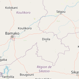
Map view of Sankarani River

Use this park location map to pinpoint Sankarani River in Guinea, understand its exact geographic position, and read its mapped placement within the surrounding landscape more clearly.

Pigeon | © OpenStreetMap contributors
Park atlas

Compare regional protected areas and connected river basin geographies across West Africa

Exploring Other Parks Near Sankarani River and Surrounding Protected Landscapes

Visitors exploring the Sankarani River can examine adjacent protected areas and regional river basin geography in surrounding territories. Comparing related conservation landscapes provides deeper context into West African wetland ecosystems and regional terrain.
National parkKayes Region
About 233 km away#1 closest

North

Boucle du Baoulé National Park: National Park Geographic Context and Atlas Discovery

Explore mapped boundaries and regional landscape.

Boucle du Baoulé National Park is a designated national park situated in the Kayes Region, offering a focal point for geographic exploration within Mali. This entry provides critical atlas-level details on its protected landscape, enabling users to trace its mapped boundaries and understand its position within the surrounding natural terrain. Dive into the specific geography of Boucle du Baoulé National Park to enhance your understanding of protected areas and their regional significance.

Area
25,330 km²
Established
1982
IUCN
II
Climate
Arid
National parkMali
About 246 km away#2 closest

West

Kouroufing National Park: Mali's National Park with Defined Protected Landscape Boundaries

Explore the mapped geography and protected land context of Kouroufing National Park.

Kouroufing National Park is a significant protected area recognized as a national park within Mali. This entry focuses on its distinct geographic identity and mapped boundaries, essential for understanding its role in the regional atlas. Examine the park's protected landscape context and how it contributes to the natural geography of West Africa. This resource is tailored for users seeking detailed information on specific protected areas rather than broad travel advice.

Area
557 km²
Established
2002
Scope
Terrestrial
Water
No major water
National parkFaranah Region
About 265 km away#3 closest

Southwest

National Park of Upper Niger: Mapped Savanna and Forest Protected Area in Faranah Region

A key West African conservation site with critical riparian corridors.

Spanning 6,000 square kilometers, the National Park of Upper Niger serves as a primary reservoir for biodiversity in Guinea. The park features a distinct transition between open woodland savanna and forested river corridors along the Niger and Mafou Rivers. It remains a significant model for community-led conservation and habitat preservation in West Africa, representing one of the region's few areas with relatively low human impact.

Area
6,000 km²
Established
1997
IUCN
II
Relief
Mixed relief
National parkGuinea
About 265 km away#4 closest

Southwest

National Park of Upper Niger: A Geographic Overview of Guinea Protected Lands

Savanna woodland and riparian forest conservation in West Africa

Located in eastern Guinea, the National Park of Upper Niger serves as a significant conservation stronghold for the region. Its diverse terrain includes vast savanna woodlands, essential riparian forest corridors along the Niger River, and the rare Mafou dry forest. This protected area provides a critical refuge for numerous mammal species and represents a key segment of the West African savanna-forest ecosystem.

Area
6,000 km²
Established
1997
Relief
Upland
Climate
Tropical
Watercolor illustration depicting a serene landscape with a river winding through savanna and distant purple-toned hills.
National parkKankan Region
About 270 km away#5 closest

Southwest

Parc national du Haut-Niger: Protected Area Map and Geographic Landscape Profile

West African dry forest and savanna conservation zone

Parc national du Haut-Niger represents a significant conservation unit in the Kankan Region of Guinea. This protected area safeguards one of the last major stands of dry tropical forest in the region, offering a rich study in riverine geography and savanna ecology along the upper Niger River and its major tributaries.

Area
554 km²
Established
1997
IUCN
II
Relief
Mixed relief
National parkMali
About 284 km away#6 closest

West

Wongo National Park: Discover Its Protected Landscape and Geographic Atlas Context in Mali

Explore Mali's Wongo National Park mapped boundaries and regional natural landscapes.

Wongo National Park represents a significant protected area within Mali, offering a distinct entry point for exploring national park geography and mapped landscapes. This designation within the West African region provides valuable insight into protected land distribution and the surrounding natural terrain. The park's context within the broader atlas framework allows for detailed investigation of its boundaries and its place within the country's ecological and geographic framework, supporting structured discovery.

Area
534 km²
Established
2002
IUCN
II
Climate
Temperate
National parkMali
About 337 km away#7 closest

Northwest

Bafing National Park: Mali National Park Atlas and Protected Woodland Landscape

Explore the unique chimpanzee habitat and bird conservation within this West African savanna.

Bafing National Park is a cornerstone of conservation in Mali, recognized for its exclusive role in protecting chimpanzee populations within the Manding Plateau region. This extensive national park features a predominant woodland ecosystem interspersed with savanna areas, providing critical habitat for numerous bird species as designated by BirdLife International. Understanding Bafing National Park's mapped geography and protected landscape offers insight into vital primate and avian conservation efforts in West Africa.

Area
5,000 km²
Established
2000
IUCN
II
Relief
Upland
A soft watercolor illustration showing a calm, curved wetland area with gentle green hills in the background and sparse vegetation in the foreground.
Protected areaCascades
About 408 km away#8 closest

East

Lac de Tengréla Protected Area: Mapping Wetland Landscapes in the Cascades Region

Freshwater geography and regional catchment in southwestern Burkina Faso

Located near Banfora, Lac de Tengréla functions as a protected Ramsar wetland within the Comoé River system. This freshwater lake provides essential ecological value, with its elongated basin and outflow connectivity offering a distinct window into the hydrology and natural terrain of southwestern Burkina Faso.

Area
5.8 km²
Established
2009
Scope
Terrestrial
Water
Water-dominated

Common questions about visiting, size, designation, and location context for Sankarani River

Sankarani River FAQs for park facts, access, geography, and protected area context

Find quick answers about Sankarani River, including protected-area facts, park geography, trail and visitor context, and how the park fits into its surrounding country and regional landscape.
MoriAtlas Explorer

Continue Your Protected Areas Search Across the Global Atlas

Deepen your exploration by continuing the structured search for national parks and protected areas worldwide. Utilize the comprehensive filtering capabilities to compare different conservation landscapes and refine your understanding of global park geography. Discover more about the distribution and characteristics of protected natural areas.

Global natural geography