Mori Atlas logo
Marine protected areaPapahānaumokuākea Marine National Monument

Tracing the geographic boundaries and remote island atoll systems of this massive marine reserve.

Papahānaumokuākea Marine National Monument: A Vast Oceanic Protected Landscape in Hawaii

Papahānaumokuākea Marine National Monument spans over 580,000 square miles of the Pacific Ocean, encompassing a unique chain of islands, atolls, reefs, and submerged seamounts northwest of Hawaii. This protected landscape represents an expansive oceanic wilderness where volcanic geology meets diverse marine habitats. Users can examine the monument's immense geographic reach, from its southeastern volcanic remnants to the northwestern atolls, providing a clear perspective on its role in protecting critical Pacific biodiversity and maritime heritage.

marine protected areanational monumentWorld Heritage Sitenational marine sanctuarycoral reefsislands and atolls

Papahānaumokuākea Marine National Monument

Marine protected area

Park overview

Structured park overview, official facts, and landscape profile for Papahānaumokuākea Marine National Monument

Papahānaumokuākea Marine National Monument park facts, protected area profile, and essential visitor context

Review the core facts for Papahānaumokuākea Marine National Monument, including designation, size, terrain, visitor scale, habitats, and operating context in one park-focused overview.

About Papahānaumokuākea Marine National Monument

Papahānaumokuākea Marine National Monument is a vast Pacific protected region that combines open ocean, submerged banks and seamounts, coral reefs, and a chain of low-lying islands and atolls stretching northwestward from the main Hawaiian Islands. It represents one of the most ambitious efforts anywhere to protect a continuous stretch of ocean ecosystem, encompassing deep pelagic environments alongside shallow coral reef systems that have evolved largely without direct human pressure.

At the heart of the monument are the Northwestern Hawaiian Islands, a geologically ancient extension of the Hawaiian volcanic chain. Only a small fraction of the protected area, just a few square miles, consists of land above sea level, but those islands and atolls serve as critical nesting islands for seabirds, breeding grounds for sea turtles, refuges for endemic terrestrial species, and culturally important places for Native Hawaiians. The surrounding waters shelter coral reefs, deep-sea coral and sponge communities, large pelagic species, and isolated populations of marine mammals such as the Hawaiian monk seal.

The monument is jointly administered through a co-trustee model involving federal, state, and Native Hawaiian partners, an arrangement that reflects both its ecological value and its cultural significance. It is also recognized internationally as a UNESCO World Heritage Site inscribed under a combination of cultural and natural criteria, the only such site in the United States that combines natural, cultural, and mixed values in the Pacific. In 2025, its marine waters were further designated as a National Marine Sanctuary, locking in long-term ocean protection under U.S. marine sanctuary law in addition to monument status.

Beyond conservation, Papahānaumokuākea is a place of layered history. The islands hold archaeological evidence of Native Hawaiian activity, while the surrounding waters contain shipwrecks spanning several centuries and the debris of World War II engagements, including sites associated with the Battle of Midway. This convergence of ecological, cultural, and historical importance is what makes Papahānaumokuākea far more than a remote patch of ocean.

Quick facts and research context for Papahānaumokuākea Marine National Monument

Papahānaumokuākea Marine National Monument lies in the central North Pacific Ocean, covering approximately 582,578 square miles from near the main Hawaiian Islands to beyond Kure Atoll. It protects more than 70 percent of U.S. coral reef area and hosts over 7,000 marine species, including many endemic to the Hawaiian archipelago.

The monument's ten islands and atolls are part of the state of Hawaii except for Midway Atoll, which belongs to the United States Minor Outlying Islands. It is jointly managed by NOAA, the U.S. Fish and Wildlife Service, the Hawaii Department of Land and Natural Resources, and the Office of Hawaiian Affairs. Designation has been progressively layered since 1909, with major milestones in 2006 (monument creation), 2010 (World Heritage inscription), 2016 (Obama expansion), and 2025 (National Marine Sanctuary designation).

Protection and recognition

Documented marine protection scope, 2006 establishment year, and administrative records

Papahānaumokuākea Marine National Monument Protection Status and Designation History

Papahānaumokuākea Marine National Monument holds a documented marine protection scope established in the year 2006. Administrative records assemble the official designation history and management parameters without external recognition sources.

Protection details

Protection scope
Marine
Designated year
2006
Transboundary protection
No
Park context

Deeper park guide and search-rich context for Papahānaumokuākea Marine National Monument

Papahānaumokuākea Marine National Monument history, landscape, wildlife, and travel context

Explore Papahānaumokuākea Marine National Monument through its history, landscape character, ecosystems, wildlife, conservation priorities, cultural context, and seasonal travel timing in a structured park guide built for atlas discovery and search intent.

Why Papahānaumokuākea Marine National Monument stands out

Papahānaumokuākea is best known as one of the world's largest marine protected areas and a global stronghold for tropical Pacific coral reef biodiversity. It contains the majority of U.S. coral reef acreage, exceptional marine endemism, and critical habitat for endangered Hawaiian monk seals, green sea turtles, hawksbill turtles, and millions of seabirds such as Laysan albatrosses. The monument is equally distinguished by the cultural importance of the Northwestern Hawaiian Islands to Native Hawaiians, the presence of ten largely uninhabited islands and atolls spanning a vast oceanic chain, and its layered maritime history including World War II sites such as the Battle of Midway. The combination of immense scale, ecological richness, and cultural significance sets it apart from most other marine reserves.
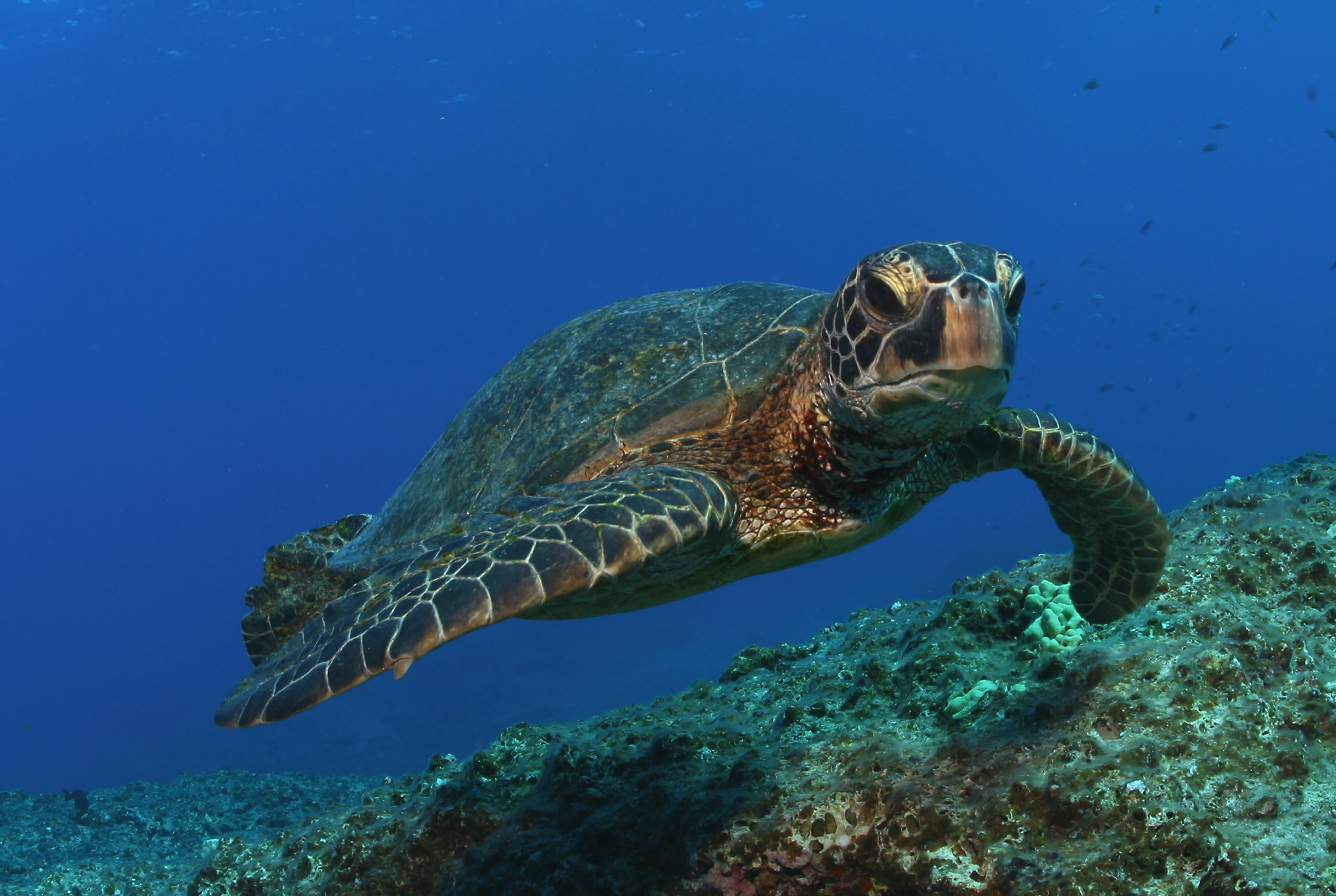
A close up view of a green sea turtle swimming in clear blue water above a rocky, textured seafloor.
A green sea turtle swimming over a rocky reef in the marine environment of the monument.

Papahānaumokuākea Marine National Monument history and protected-area timeline

The Northwestern Hawaiian Islands have held deep cultural meaning for Native Hawaiians for centuries, particularly as a place believed to represent the kinship between nature and humanity and as a destination of the spirit after death. Archaeological remains on Nīhoa and Mokumanamana testify to longstanding human presence and ceremonial activity across the island chain.

Federal protection began on February 3, 1909, when President Theodore Roosevelt created the Hawaiian Islands Bird Reservation through Executive Order 1019 in response to severe overharvesting of seabirds and to protect the NWHI's importance as nesting habitat. President Franklin D. Roosevelt redesignated the area as the Hawaiian Islands National Wildlife Refuge in 1940, and additional layers of protection followed, including the establishment of the Midway Atoll National Wildlife Refuge in 1988 and the Kure Atoll State Wildlife Sanctuary in 1993.

In 2000, President Bill Clinton created the Northwestern Hawaiian Islands Coral Reef Ecosystem Reserve, initiating a long process to potentially designate the waters as a National Marine Sanctuary. Hawaii Governor Linda Lingle added a state marine refuge designation in 2005. In 2006, after viewing the documentary Voyage to Kure at the White House, President George W. Bush used the Antiquities Act to designate the monument, creating immediate protection that bypassed slower consultation processes. The name Papahānaumokuākea, honoring the Hawaiian Earth Mother goddess and creation myth, was added by presidential proclamation in 2007.

From 2007 to 2010, the monument's managers worked toward international recognition, obtaining Particularly Sensitive Sea Area status through the International Maritime Organization in 2007 and achieving UNESCO World Heritage inscription in 2010. In 2016, President Barack Obama expanded the monument more than fourfold, extending its boundaries to the U.S. exclusive economic zone west of 163° W, making Papahānaumokuākea the largest marine protected area in the world at that time. The Biden administration then pursued National Marine Sanctuary designation, which was finalized on January 15, 2025, adding a more durable legal framework under the National Marine Sanctuaries Act. Future management has been complicated by ongoing debates over commercial fishing access, regulatory enforcement, and the impacts of new technologies such as rocket launch corridors near the monument.

Papahānaumokuākea Marine National Monument landscape and geographic character

The monument's landscape is overwhelmingly oceanic, defined by the northwestern reach of the Hawaiian-Emperor seamount chain rather than by mountainous terrain. Scattered across more than a thousand miles of open Pacific are small islands, atolls, reefs, and dozens of submerged banks and seamounts. The ten islands and atolls that break the ocean surface include Nīhoa, Necker Island (Mokumanamana), French Frigate Shoals, Gardner Pinnacles, Maro Reef, Laysan Island, Laysan Atoll surroundings, Pearl and Hermes Atoll, Midway Atoll, and Kure Atoll.

Most of the exposed land is low in elevation and small in footprint, shaped by long weathering of volcanic rock and the accumulation of coral and sand. The islands support little or no soil development and are dominated by sand, coral rubble, salt spray, and shifting vegetation patterns that respond to wind and rainfall. Beaches and sand spits are common, while cliffs and rocky outcrops appear on the more geologically older islands such as Nīhoa. The waterscape itself is equally varied: shallow turquoise reef flats, lagoon systems inside atolls, steep dropoffs to abyssal depths, and underwater seamounts and banks rising from the deep ocean floor.

In addition to natural shaping forces, the islands bear visible traces of human-era events. Hurricanes, particularly Hurricane Walaka in 2018, have reshaped atoll islets, while military infrastructure from World War II and the Cold War, including runways and remnants on Midway and French Frigate Shoals, are part of the physical landscape as well. The overall impression is of a remote, sparsely populated seascape where wind, ocean, and time have created a string of small but ecologically vital landforms separated by immense stretches of open ocean.
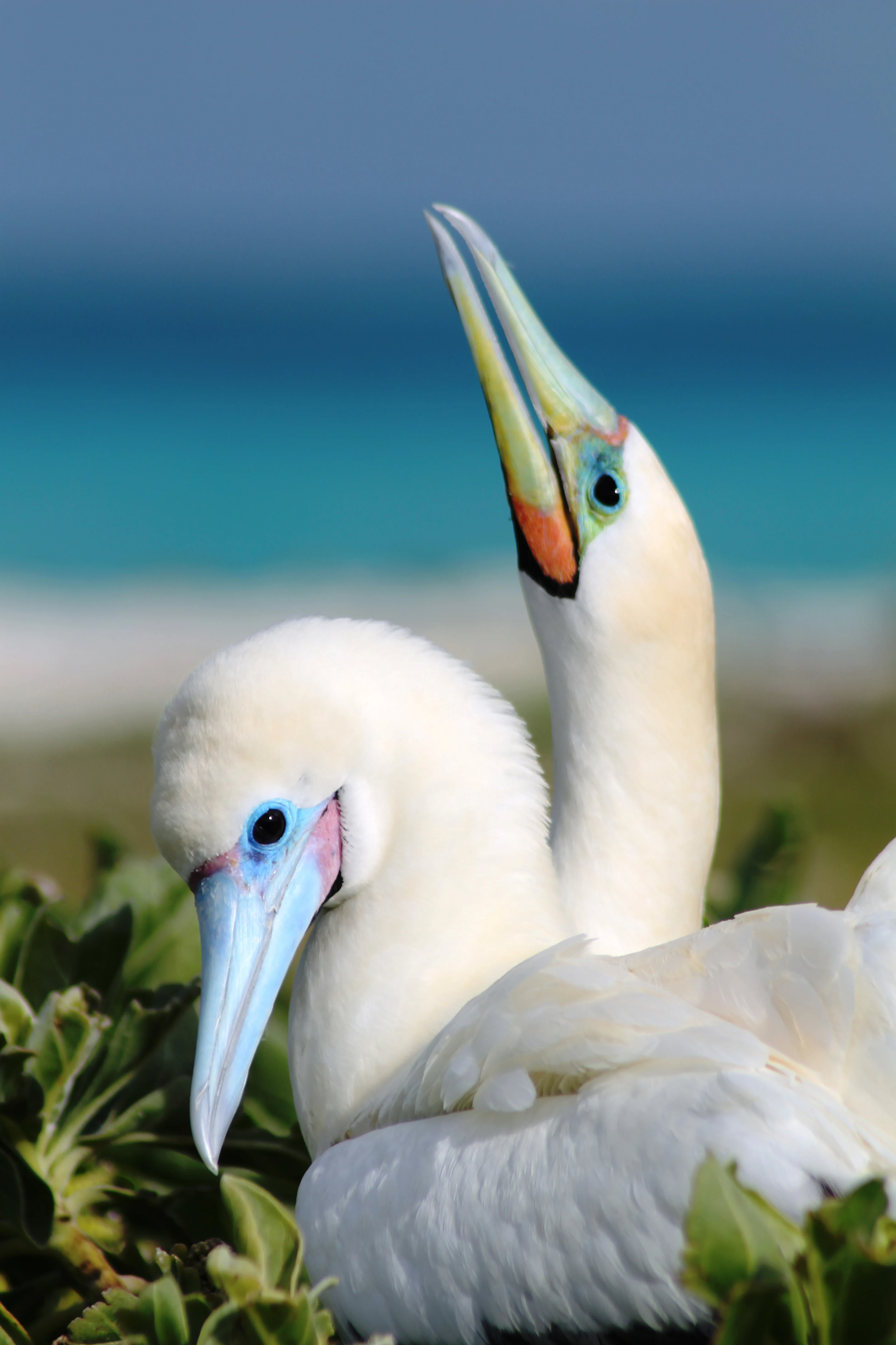
Two white seabirds with prominent beaks and blue facial skin nesting in low green vegetation, with a blurred blue ocean background.
Red-footed boobies nesting at French Frigate Shoals in Papahānaumokuākea Marine National Monument.

Papahānaumokuākea Marine National Monument ecosystems, habitats, and plant life

Papahānaumokuākea sits at the intersection of tropical Pacific reef ecosystems and open-ocean pelagic ecosystems, with elements that are genuinely unusual because of their isolation and limited direct human impact. Coral reefs are central to the monument's identity, supporting diverse fish, invertebrate, and algae communities across shallow reef flats, lagoons, and deeper mesophotic reef zones. Recent deep-water expeditions around Kure Atoll and elsewhere have documented new species of coral and unusual deep-sea sponges, including one of the largest sponges ever recorded.

Above and below the surface, the islands and atolls create a unique layered ecological system. Vegetation on the islands is sparse and salt-tolerant, composed largely of low grasses, vines, native shrubs, and specialized coastal plants, many of which are endemic. The combination of high winds, salty conditions, low soil, and limited freshwater has created an ecological filter that produces endemic plants, insects, and land birds found nowhere else on Earth.

The marine environment is exceptionally rich in seabird-friendly habitat, sea turtle nesting beaches, and isolated fish populations. Connectivity between reef and open-ocean systems is a defining feature, allowing species ranges to extend from shallow coastal habitats to deep seamounts. Climate conditions vary across the chain, with the southeastern end experiencing warmer, more tropical waters and the northwestern end approaching limits where reef development becomes increasingly marginal, lending Papahānaumokuākea an unusual ecological gradient that scientists value for understanding reef resilience and climate responses.
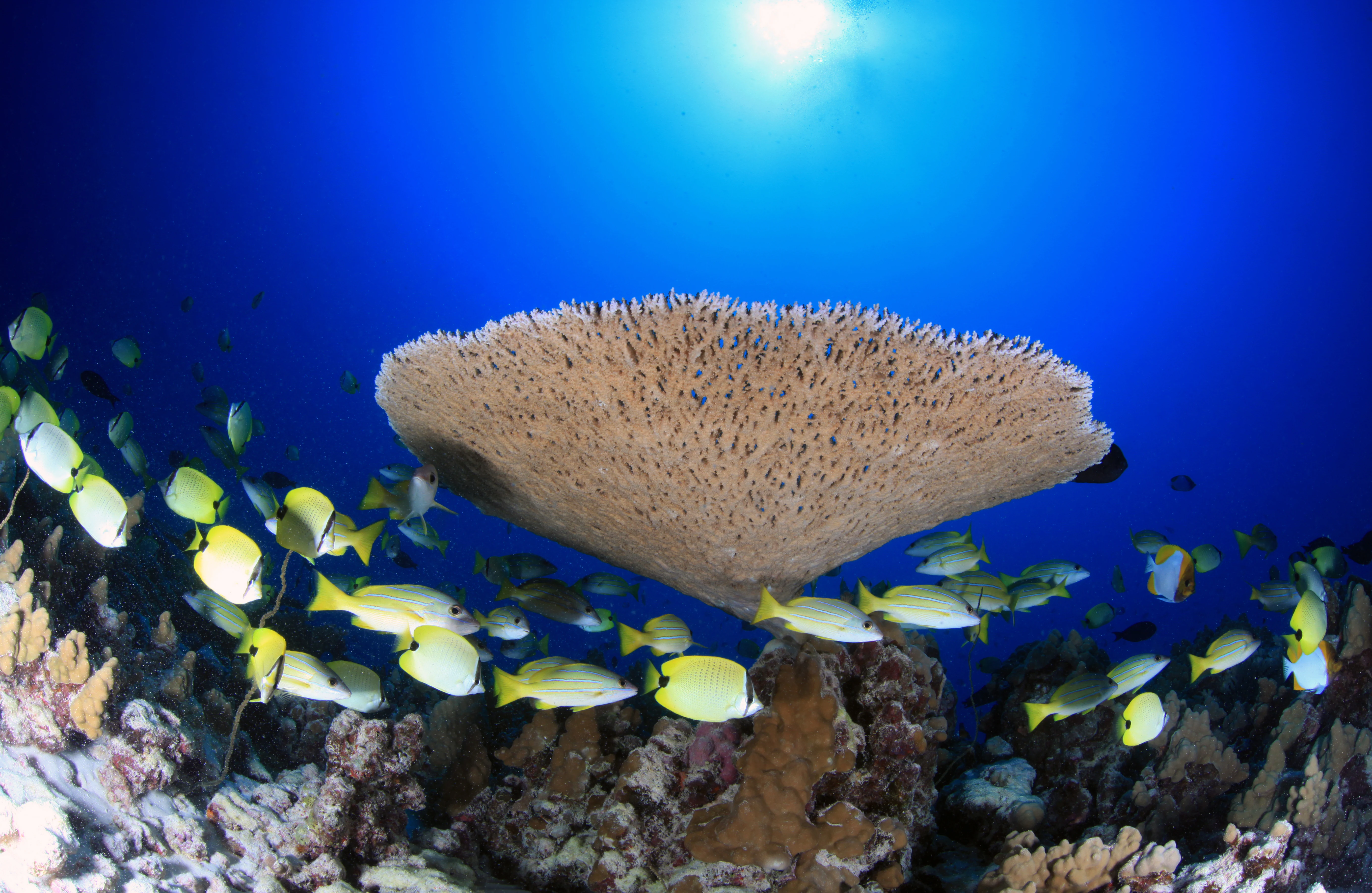
Underwater view of a large, flat, fan-shaped Acropora coral colony surrounded by many small, bright yellow fish above a rocky reef floor with deep blue water in the background.
A large Acropora cytherea coral colony surrounded by a school of yellow fish at French Frigate Shoals.

Papahānaumokuākea Marine National Monument wildlife and species highlights

Monument fauna include only a few species of endemic land birds, but each of them is among the rarest in the Hawaiian archipelago. The Nihoa Millerbird and Nihoa Finch survive only on tiny Nihoa, while the Laysan Duck and Laysan Finch are restricted to the small island of Laysan. Major seabird colonies, including millions of Laysan albatrosses along with black-footed albatrosses, red-footed boobies, masked boobies, boobies, frigatebirds, terns, and shearwaters, nest across nearly every island and atoll of the chain.

The monument is also a major nesting area for green sea turtles. Roughly 95 percent of Hawaiian green sea turtles rely on the sandy islets of French Frigate Shoals as nesting grounds. Endangered hawksbill sea turtles are also present in the area. Hawaiian monk seals, one of the rarest seals in the world, haul out and breed on the islands and atolls, particularly at Midway, French Frigate Shoals, and Pearl and Hermes, where they are protected from human disturbance and mainland pressures.

Reef and pelagic wildlife is equally abundant. Researchers have documented colorful reef fishes such as masked angelfish, Potter's angelfish, Thompson's anthias, red tail wrasse, and Hawaiian squirrelfish, along with pelagic species such as spinner dolphins and Bryde's whales. Spiny lobsters that were historically abundant have not recovered from past overharvesting, illustrating how the monument both preserves and, in some cases, struggles to restore its wildlife. The combination of iconic seabirds, rare endemic land birds, endangered marine mammals, and a high diversity of marine fishes makes Papahānaumokuākea one of the most ecologically important marine wildlife regions in the United States.

A female Laysan duck stands in shallow water alongside three small, brown, fluffy ducklings.
A female Laysan duck with her ducklings in the shallow waters of Midway Atoll.

Papahānaumokuākea Marine National Monument conservation status and protection priorities

Papahānaumokuākea is a centerpiece of conservation in the Pacific because it protects a near-continuous chain of coral reef, island, and deep-ocean ecosystems across an unmatched scale. It safeguards roughly 70 percent of U.S. coral reef area and a striking number of endemic marine and terrestrial species, functioning as a natural laboratory for studying coral resilience, climate change, and the recovery of seabird, seal, and turtle populations.

The monument's layered legal framework is itself a conservation story. Federal protection began in 1909 with a seabird-focused reservation and grew through wildlife refuges and a 2000 coral reef ecosystem reserve before becoming a national monument in 2006. The 2016 expansion under President Obama dramatically increased its scope, and the 2025 designation of the national marine sanctuary added another durable layer of protection under the National Marine Sanctuaries Act. The co-trustee structure ensures that conservation decisions involve federal agencies, the state of Hawaii, and the Office of Hawaiian Affairs, which brings Native Hawaiian cultural and traditional resource perspectives into management.

The worldwide significance of the monument is reflected in its 2010 inscription as a UNESCO World Heritage Site under a combined set of natural and cultural criteria. Recognized wider values include its Particularly Sensitive Sea Area status, secured in 2007 through the International Maritime Organization, which provides additional protections against international shipping impacts. Despite this strong framework, conservation in Papahānaumokuākea is dynamic: past commercial fishing depleted stocks of spiny lobster, present-day debates over commercial fishing access continue, and emerging threats such as marine debris, ocean acidification, and space launch corridors pose new challenges. Even with these pressures, the monument is widely viewed as a global model for protecting large, remote ocean ecosystems at the policy and research levels.

Papahānaumokuākea Marine National Monument cultural meaning and human context

For Native Hawaiians, the Northwestern Hawaiian Islands represent an ancestral and spiritual homeland rather than simply a remote region. Traditional knowledge describes the islands as the place from which life originates and to which the spirits return after death, and Papahānaumokuākea as a name ties them to the Earth Mother and the Hawaiian creation story. Archaeological sites on Nīhoa and Mokumanamana, including stone platforms, religious structures, and habitation remains, are physical evidence of long-standing Native Hawaiian activity and ceremonial use of these islands.

The Hawaiian practice of building hula and chants associated with the Northwestern Hawaiian Islands keeps the islands culturally present in contemporary Hawaiian life. Cultural practitioners such as Hawaiian kumu hula Pualani Kanakaʻole Kanahele have publicly translated the meaning of Papahānaumokuākea, helping anchor the name in Hawaiian cosmological understanding. The co-trustee role of the Office of Hawaiian Affairs within the monument's management is itself a recognition that Native Hawaiian voices must help shape stewardship.

Midway Atoll and surrounding waters also carry a powerful layer of modern history through the Battle of Midway, a pivotal naval engagement of World War II. The wreck sites of ships such as the USS Yorktown and the Imperial Japanese Navy carrier Akagi serve as maritime war memorials and are part of why the monument is inscribed as a UNESCO World Heritage Site for its cultural significance. The combination of indigenous Hawaiian heritage and 20th-century military heritage gives Papahānaumokuākea a rare dual cultural identity that is recognized at the highest international levels of heritage protection.
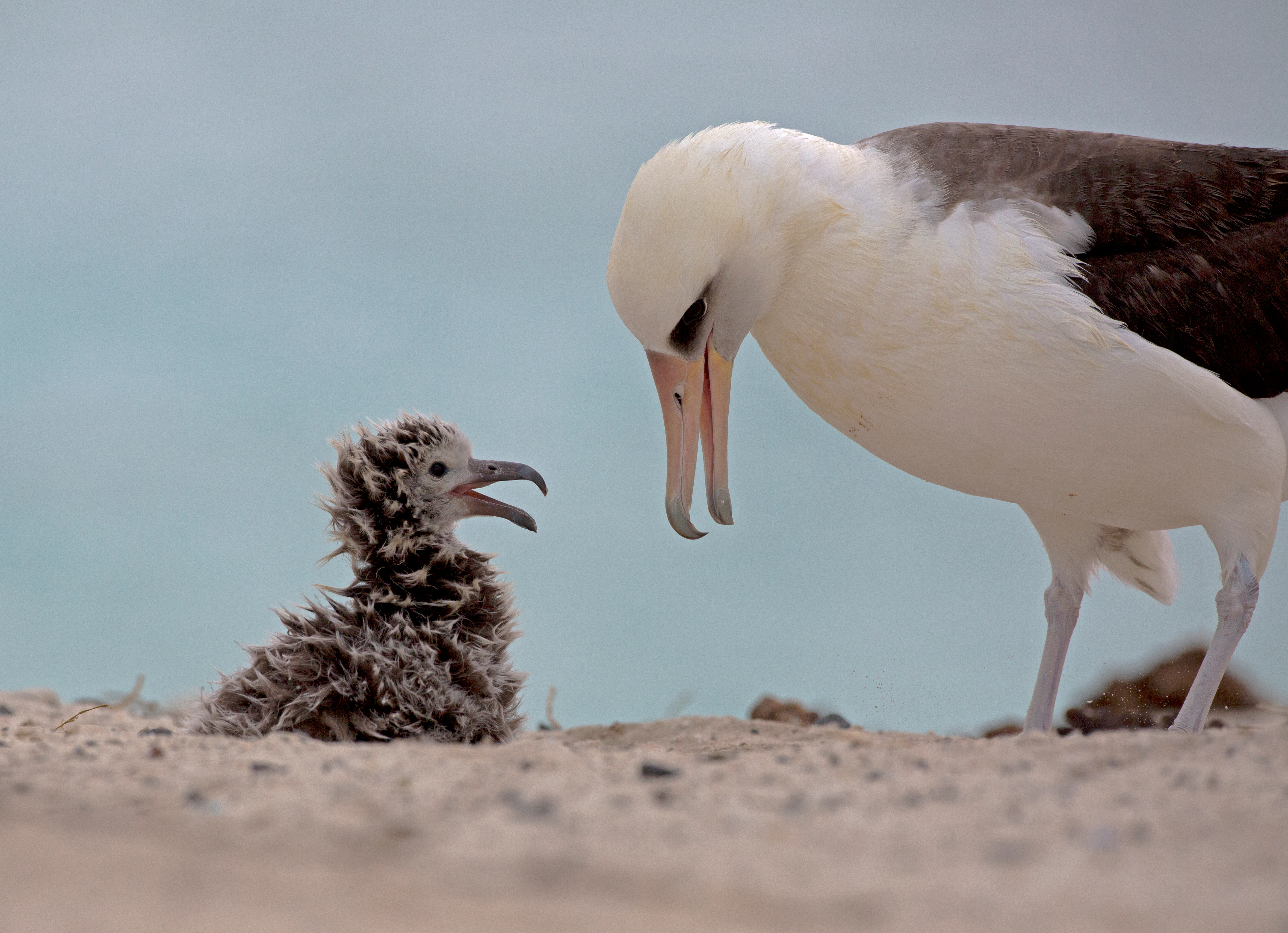
An adult Laysan albatross stands over its fluffy, dark brown chick on a sandy surface, both with beaks slightly open.
An adult Laysan albatross interacts with its downy chick in Papahānaumokuākea Marine National Monument.

Top sights and standout views in Papahānaumokuākea Marine National Monument

Papahānaumokuākea's scale alone is one of its most striking qualities. The protected area covers roughly 582,578 square miles, making it larger than all U.S. national parks combined and roughly comparable in surface area to the Gulf of Mexico. Within this expanse lie 70 percent of U.S. coral reef habitat, ten islands and atolls, dozens of submerged banks and seamounts, and more than 7,000 marine species.

Its biological highlights include the highest concentration of endemic marine species under U.S. jurisdiction, the only nesting range of several highly endangered land birds, critical habitat for Hawaiian monk seals and green sea turtles, and seabird colonies numbering in the millions. Its cultural highlights include archaeological sites of deep Native Hawaiian significance and the maritime history of the Battle of Midway. Its recognition as both a UNESCO World Heritage Site and a National Marine Sanctuary makes Papahānaumokuākea one of the few places where ecological rarity, indigenous heritage, and military sacrifice intersect in a single protected landscape.
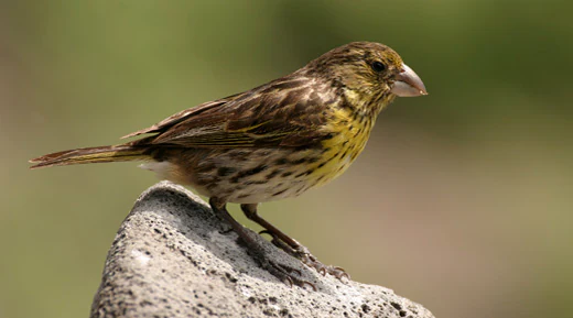
A small songbird with brown streaked plumage and a yellowish breast perching on a grey volcanic rock against a blurred background.
The Nihoa finch is an endangered bird species endemic to Nihoa island within the Papahānaumokuākea Marine National Monument.

Best time to visit Papahānaumokuākea Marine National Monument

Because the monument itself is essentially closed to general public access, with only limited permitted tours and research visits, traditional seasonal visiting advice applies more to the broader Hawaiian region than to the monument's interior. The Northwestern Hawaiian Islands experience mild tropical temperatures year-round, but the cooler and less humid months from late spring through early fall tend to offer calmer seas and better visibility for potential permitted vessel trips and charter expeditions to the outer islands.

Winter and spring months can be wetter and bring stronger trade winds and swells across the island chain, occasionally producing tropical storms. The peak seabird breeding season spans from late winter through summer, when large numbers of albatrosses, boobies, and terns are nesting on islands such as Midway, Laysan, and French Frigate Shoals. Sea turtle nesting peaks during the summer months at islands such as French Frigate Shoals. Anyone considering a permitted visit should plan well in advance, since access is regulated by monument co-trustees and typically requires special authorization.


Monthly climate preview

Long-term representative point measurements tracking annual temperature and precipitation rhythm

Papahānaumokuākea Marine National Monument Climate Normals and Weather by Month

Papahānaumokuākea Marine National Monument records measured monthly temperature ranges between 21 degrees and 27 degrees Celsius alongside varying daily precipitation rates across the year. Reviewing the complete twelve-month climatology dataset reveals deeper variations in historical weather patterns at this protected coordinate.
Annual mean24 °C
21 °C26 °C
Jan22°
Feb21°
Mar21°
Apr22°
May23°
Jun25°
Jul26°
Aug26°
Sep26°
Oct26°
Nov24°
Dec23°
Warmest month
September

26.3 °C

Coolest month
February

21.1 °C

Wettest month
November

2.8 mm/day

Driest month
June

0.8 mm/day

Park location guide

Geography guide, regional context, and park location map for Papahānaumokuākea Marine National Monument

Papahānaumokuākea Marine National Monument park geography, regions, and map view in United States of America

Understand where Papahānaumokuākea Marine National Monument sits in United States of America through a broader geographic reading of the surrounding landscape, nearby location context, and its mapped position within the national park landscape.

How Papahānaumokuākea Marine National Monument fits into United States of America

The United States of America is a federal presidential republic and one of the world's largest countries by area and population. It consists of 50 states across a vast territory spanning multiple time zones, with its capital in Washington, D.C. and largest city in New York City. The nation has a diverse economy, influential political system, and significant cultural and military presence globally.

Wider geography shaping Papahānaumokuākea Marine National Monument in United States of America

The United States occupies a vast territory in North America, bordered by Canada to the north and Mexico to the south. The 48 contiguous states stretch from the Atlantic to the Pacific Ocean, while Alaska occupies the northwestern region and Hawaii is an archipelago in the Pacific. The country encompasses diverse terrain including the Rocky Mountains, Appalachian Mountains, Great Plains, and extensive river systems.

Map view of Papahānaumokuākea Marine National Monument

Use this park location map to pinpoint Papahānaumokuākea Marine National Monument in United States of America, understand its exact geographic position, and read its mapped placement within the surrounding landscape more clearly.

Pigeon | © OpenStreetMap contributors

Location context for Papahānaumokuākea Marine National Monument

Hawaii

Visual exploration of remote Pacific islands, coral reefs, and protected marine habitats

Papahānaumokuākea Marine National Monument Photos, Landscapes, and Scenery

Visual documentation captures the remote oceanic terrain, shallow reef flats, and scattered atolls defining Papahānaumokuākea Marine National Monument. Detailed photography provides a clear window into the expansive marine protected area, revealing vulnerable wildlife habitats and wild island environments across the Northwestern Hawaiian chain.

A close up view of a green sea turtle swimming in clear blue water above a rocky, textured seafloor.

Two white and black masked boobies standing on top of the shells of two large green sea turtles, which are resting on a white sandy beach with turquoise ocean water in the background.

Two white seabirds with prominent beaks and blue facial skin nesting in low green vegetation, with a blurred blue ocean background.

Underwater view of a large, flat, fan-shaped Acropora coral colony surrounded by many small, bright yellow fish above a rocky reef floor with deep blue water in the background.

A female Laysan duck stands in shallow water alongside three small, brown, fluffy ducklings.

A small brownish-gray bird, the Nihoa Millerbird, perched on a green branch with a blue leg band visible, surrounded by lush green foliage.

An adult Laysan albatross stands over its fluffy, dark brown chick on a sandy surface, both with beaks slightly open.

A small songbird with brown streaked plumage and a yellowish breast perching on a grey volcanic rock against a blurred background.

Two Hawaiian monk seals on a white sandy beach near turquoise ocean water.

A close-up underwater shot of a dense school of red, white-striped squirrelfish with large dark eyes swimming near a coral and rock reef.

A group of colorful tropical fish swimming over a textured, coral-covered reef floor.

A group of small, dark hatchling green sea turtles swimming near the turbulent surface of the blue ocean.

A bright orange-red pencil urchin resting on light purple and white coral underwater.

An aerial view of a Bryde's whale surfacing in deep blue ocean water, creating a small wake.

A close up view of a pink, branching bubblegum coral with a thin, segmented brittle star coiled around its limbs in deep ocean water.

Two Hawaiian monk seals swimming near the water surface, viewed from directly above in clear, shallow turquoise water.

Park atlas

Compare adjacent marine protected areas and regional oceanic landscapes across the Pacific.

Parks Near Papahānaumokuākea Marine National Monument and Related Ocean Reserves

Browsing other protected areas near Papahānaumokuākea Marine National Monument reveals broader oceanic ecosystems and coral reef reserves across the region. Extending the geographic review helps connect isolated Pacific habitats with wider marine conservation networks.
Marine protected areaHawaii
About 1,166 km away#1 closest

East

Hawaiian Islands Humpback Whale National Marine Sanctuary Geographic and Protected Area Map

Explore marine boundaries and reef ecosystems in the Hawaii archipelago.

The Hawaiian Islands Humpback Whale National Marine Sanctuary provides essential protection for vast underwater habitats stretching across the Hawaiian archipelago. This protected area supports a specialized ecosystem featuring diverse coral reefs and significant whale breeding grounds. Understanding the sanctuary requires examining its unique spatial gradient from shallow shorelines to deep oceanic waters and its role in regional conservation.

Area
3,626 km²
Established
1992
IUCN
IV
Access
Easy access
National parkMaui County
About 1,550 km away#2 closest

East

Haleakalā National Park: Exploring its Protected Landscape and Maui County Geography

Understand the park's mapped boundaries and regional terrain context.

Haleakalā National Park represents a vital protected landscape, offering unique insights into the geography of Maui County. This entry provides a foundation for understanding the park's specific identity as a national park and its role within the broader regional context. Explore its protected-area characteristics and the mapped natural terrain that defines its landscape, making it a key destination for geographic exploration.

Area
134.62 km²
Established
1961
IUCN
II
Visitors
1.1M annual
National parkUnited States of America
About 1,660 km away#3 closest

East

Hawaiʻi Volcanoes National Park: National Park Geographic Atlas and Protected Landscape

Mapped volcanic terrain and regional protected area context.

Delve into the geographic identity of Hawaiʻi Volcanoes National Park, a notable protected area within the United States of America. This park offers unique volcanic landscapes and provides an invaluable resource for understanding mapped terrain, regional geography, and the specific boundaries of conservation lands. Explore its distinct environmental features and discover its significance through a detailed atlas-oriented lens.

Area
1,434.45 km²
Established
1916
IUCN
II
Visitors
1.4M annual
Protected areaMarshall Islands
About 2,460 km away#4 closest

Southwest

Bokak Atoll Protected Area: Mapping the Northern Ratak Chain of the Marshall Islands

A remote coral atoll with a rare perched lagoon and pristine reef ecosystem

Bokak Atoll represents a primary example of an undisturbed central Pacific coral atoll, defined by its lack of introduced species and its striking perched lagoon. The landscape consists of low coral islets along a crescent reef, creating a specialized habitat for seabird colonies and stony coral reefs. This geographic overview examines the atoll's isolation and its status as a critical protected natural area within the wider Marshall Islands territory.

Area
129 km²
Relief
Lowland
Climate
Tropical
Access
Remote access
Protected areaMarshall Islands
About 2,508 km away#5 closest

Southwest

Bikar Atoll Protected Area: Geographic Overview of a Remote Marshall Islands Coral Atoll

A pristine, uninhabited coral sanctuary and critical Pacific marine habitat.

Bikar Atoll is a remote, diamond-shaped coral ring located in the Ratak Chain of the Marshall Islands. Defined by its shallow lagoon, continuous reef structure, and arid islets, the atoll serves as a vital nesting site for seabirds and green turtles. This protected area remains one of the most ecologically undisturbed sites in the Pacific, offering rare insight into natural atoll morphology and island conservation.

Area
0.5 km²
Established
2025
Relief
Lowland
Climate
Tropical
Protected areaMarshall Islands
About 2,661 km away#6 closest

Southwest

Ailuk Atoll Protected Area: Geography and Mapped Coral Landscapes in the Marshall Islands

Pacific atoll terrain, lagoon systems, and island geography

Study the geographic composition of Ailuk Atoll, featuring its classic ring of coral islets, deep-water reef passes, and vast central lagoon. This protected area offers insight into the subsidence-driven formation of Marshallese island chains and the enduring human reliance on traditional maritime navigation within a fragile Pacific ecosystem.

Area
5.4 km²
Relief
Lowland
Climate
Tropical
Access
Remote access
Watercolor painting of a landscape showing a body of water surrounded by green land with trees and distant hills, with soft pink and purple washes on the sides
Protected areaMarshall Islands
About 2,758 km away#7 closest

Southwest

Likiep Atoll: A Mapped Protected Area in the Marshall Islands Ratak Chain

Coral atoll geography and historical colonial landscape features

Likiep Atoll consists of 65 islands encircling a 424 square kilometer lagoon. As a protected area in the Marshall Islands, it offers insight into low lying atoll topography, unique marine environments, and the cultural remnants of successive colonial administrations.

Area
10.26 km²
Relief
Lowland
Climate
Tropical
Access
Remote access
Protected areaMarshall Islands
About 2,781 km away#8 closest

Southwest

Arno Atoll: A Rare Triple Lagoon Coral Protected Area in the Marshall Islands

Mapped geography and hydrological landscape context

Arno Atoll stands out as a unique geographic entity in the Ratak Chain with its triple lagoon configuration. Spanning 133 islands in the North Pacific, this protected area offers insight into atoll reef systems, low lying coral landscapes, and the environmental framework of the Marshall Islands.

Area
13 km²
Relief
Lowland
Climate
Tropical
Scope
Mixed

Common questions about visiting, size, designation, and location context for Papahānaumokuākea Marine National Monument

Papahānaumokuākea Marine National Monument FAQs for park facts, access, geography, and protected area context

Find quick answers about Papahānaumokuākea Marine National Monument, including protected-area facts, park geography, trail and visitor context, and how the park fits into its surrounding country and regional landscape.
MoriAtlas Explorer

Continue Your Protected Areas Search Across the Global Atlas

Deepen your exploration by continuing the structured search for national parks and protected areas worldwide. Utilize the comprehensive filtering capabilities to compare different conservation landscapes and refine your understanding of global park geography. Discover more about the distribution and characteristics of protected natural areas.

Global natural geography