

Mori Atlas logo
National parkParamillo National Natural Park

Discover the mapped boundaries and natural terrain context of this significant Colombian protected area.

Paramillo National Natural Park: Colombia's Protected National Park Landscape and Geography

(Parque Natural Nacional Paramillo)

Paramillo National Natural Park stands as a vital protected area within Colombia's expansive geography. This page offers an in-depth atlas-style exploration of its distinct natural landscape, focusing on its mapped boundaries and its role as a designated national park. Understand the geographic context of Paramillo National Natural Park and its significance within the broader Colombian protected lands framework, providing a factual basis for landscape discovery.

Páramo ecosystemsAndean cloud forestTropical AndesBird conservationSpectacled bear habitatWatershed protection

Paramillo National Natural Park

National park

Park overview

Structured park overview, official facts, and landscape profile for Paramillo National Natural Park

Paramillo National Natural Park park facts, protected area profile, and essential visitor context

Review the core facts for Paramillo National Natural Park, including designation, size, terrain, visitor scale, habitats, and operating context in one park-focused overview.

About Paramillo National Natural Park

Paramillo National Natural Park occupies a strategic position in the northern Colombian Andes, where the Cordillera Occidental range transitions into the Caribbean lowland plains. The protected area encompasses the Paramillo Massif, a complex mountainous region that divides the watersheds of several major river systems flowing toward the Caribbean coast. The park's altitudinal range spans from approximately 200 meters above sea level in the lowland foothills to 3,730 meters at Cerro Paramillo, creating a continuous gradient of ecosystems that includes lowland tropical forest, premontane cloud forest, Andean forest, and páramo. This ecological continuity makes the park exceptionally valuable for biodiversity conservation, as it provides habitat connectivity across elevational zones that would otherwise be fragmented by human land use. The park falls within the Tropical Andes biodiversity hotspot, recognized globally as one of the most species-rich regions on the planet. Management of the protected area focuses on maintaining ecological processes, protecting water resources that support downstream communities, and preserving the unique species assemblages that depend on these Andean ecosystems.

Quick facts and research context for Paramillo National Natural Park

Paramillo National Natural Park is located in the departments of Antioquia and Córdoba in northern Colombia, covering portions of the Paramillo Massif where three mountain subrange systems converge. The park protects the headwaters of major river systems including the San Jorge and Sinú rivers, which flow northward into the Caribbean lowlands. The protected area contains some of the northernmost extent of páramo ecosystems in South America, representing a critical biogeographic boundary where Andean flora meets Caribbean-influenced environments. The park is one of only two known locations for the endangered Paramillo tapaculo, a bird species endemic to this specific highland region.

Protection and recognition

Verifying the official terrestrial boundaries and international conservation framework of the park.

Paramillo National Natural Park Protection Status and Conservation Designation

Geographic researchers can explore the official terrestrial protection status and documented designation framework established for Paramillo National Natural Park. Accessing verified administrative records helps map the global conservation network while clarifying how regional conservation areas fit into international databases.

Protection details

Protection scope
Terrestrial
Park context

Deeper park guide and search-rich context for Paramillo National Natural Park

Paramillo National Natural Park history, landscape, wildlife, and travel context

Explore Paramillo National Natural Park through its history, landscape character, ecosystems, wildlife, conservation priorities, cultural context, and seasonal travel timing in a structured park guide built for atlas discovery and search intent.

Why Paramillo National Natural Park stands out

Paramillo National Natural Park is best known for protecting the northernmost páramo ecosystems in the Tropical Andes, a rare and ecologically sensitive high-altitude environment characterized by frailejón shrubs, cushion plants, and episodic fog. The park also protects significant populations of the spectacled bear, South America's only native bear species, which inhabits the highland forests and páramo zones. The Paramillo Massif itself is notable for being one of the few places in the world where the paramillo tapaculo survives, a small ground-dwelling bird that has become a conservation flagship for the region. The mountain range is further distinguished by its theoretical visibility over 500 kilometers to the Sierra Nevada de Santa Marta, representing one of Earth's longest intervisible sight lines between two points.

Paramillo National Natural Park history and protected-area timeline

The Paramillo Massif and surrounding regions have been recognized for their ecological importance since the mid-20th century, with formal protection efforts beginning in the 1970s and 1980s as Colombia expanded its national park system. The area was designated as a national natural park to protect the highland watersheds, biodiversity, and the distinctive páramo ecosystems that characterize the region. Colombia's national park system has historically prioritized protection of representative ecosystems across the country's diverse biomes, and Paramillo was established to ensure preservation of the northernmost páramo and high Andean forest habitats. The park exists within a broader context of conservation planning that recognizes the importance of the Tropical Andes region for global biodiversity and the ecological services provided by Andean watersheds to millions of people in surrounding lowlands.

Paramillo National Natural Park landscape and geographic character

The Paramillo Massif forms a dramatic mountainous landscape at the northern terminus of the Cordillera Occidental, where the Andes range meets the Caribbean coastal plain. Three distinct subrange systems radiate outward from the central massif: the Abibe Mountains form a natural border between Antioquia and Córdoba departments, the San Jerónimo Mountains separate the San Jorge and Sinú river watersheds, and the Ayapel Mountains divide the San Jorge and Cauca river basins. The terrain is characterized by steep ridges, deep valleys, and abrupt elevation changes that create diverse microclimates and habitat conditions. The highest peaks, including Cerro Paramillo at 3,730 meters, rise above the tree line into páramo zones where vegetation is adapted to constant cloud immersion, high humidity, and temperature extremes. Lower elevations feature dense cloud forest where persistent fog drip maintains moist conditions even during dry seasons.

Paramillo National Natural Park ecosystems, habitats, and plant life

The ecological diversity of Paramillo National Natural Park reflects its position at a biogeographic crossroads between Andean and Caribbean ecosystems. The páramo ecosystem, found at elevations above approximately 3,000 meters, represents one of the most distinctive high-altitude environments in the northern Andes. Characteristic páramo vegetation includes the iconic frailejón (Espeletia species), a large rosette-forming shrub that has become symbolic of Andean high-elevation environments. Below the páramo zone, Andean cloud forests feature dense vegetation adapted to constant moisture, with abundant epiphytes, ferns, and mosses coating tree trunks and branches. These forests transition into premontane formations at lower elevations, where the species composition shifts toward more tropical elements as the gradient descends toward the Caribbean plains. The watersheds originating in the park support downstream ecosystems and provide critical water resources for agricultural and municipal use in the surrounding regions.

Paramillo National Natural Park wildlife and species highlights

Paramillo National Natural Park supports notable wildlife populations, with several species of conservation significance depending on the protected area's habitats. The park is one of only two known locations for the Paramillo tapaculo (Scytalopus canus), a small ground-dwelling bird species endemic to this specific region of the Colombian Andes. This endangered bird inhabits the dense understory of cloud forests and páramo edges, where it forages for insects and other small invertebrates among ground cover and fallen leaves. The spectacled bear (Tremarctos ornatus), South America's only bear species, inhabits the highland forests and páramo zones of the massif, using the diverse elevation range to access different food resources throughout the year. Additional mammal species typical of Andean environments include various species of deer, primates, and smaller mammals that occupy different forest strata and habitat zones within the park.

Paramillo National Natural Park conservation status and protection priorities

The protection of Paramillo National Natural Park addresses several critical conservation priorities at national and global scales. The park preserves the northernmost extent of páramo ecosystems in the Tropical Andes, representing a biogeographic limit for these high-altitude communities that are highly sensitive to climate change and land use pressure. Conservation of the Paramillo tapaculo depends almost entirely on protection of its limited habitat within the park, making this protected area essential for the species' survival. The watersheds protected by the park provide ecosystem services including water regulation, sediment retention, and biodiversity maintenance that benefit downstream communities across the Caribbean lowlands. The park contributes to Colombia's commitments under international conservation frameworks and represents a key area within the national strategy for preserving Andean biodiversity.

Paramillo National Natural Park cultural meaning and human context

The Paramillo Massif region has been inhabited by indigenous communities for centuries, with the mountainous terrain and river valleys providing resources and traditional territories. The departments of Antioquia and Córdoba that encompass the park contain diverse populations with historical connections to the land, though specific indigenous territories within the current park boundaries may be limited due to the protected area's high-elevation character. Local communities in the surrounding municipalities depend on watershed services originating in the massif, with the rivers flowing from Paramillo supporting agriculture, livestock, and domestic water supply. The park exists within a landscape of mixed land uses where conservation objectives must balance with local livelihoods and economic activities.

Top sights and standout views in Paramillo National Natural Park

Paramillo National Natural Park protects one of the northernmost páramo ecosystems in South America, a rare high-altitude environment of global conservation significance. The park contains the Paramillo Massif's highest peaks, including Cerro Paramillo at 3,730 meters, offering dramatic Andean scenery within northern Colombia. Critical habitat for the endangered Paramillo tapaculo makes the park essential for conservation of this endemic bird species. Spectacled bears inhabit the highland zones, representing one of the northernmost populations of this distinctive South American mammal. The mountain ranges radiating from the massif create complex watersheds that support downstream ecosystems and communities across the Caribbean lowlands.

Best time to visit Paramillo National Natural Park

The best time to visit Paramillo National Natural Park typically corresponds to the drier seasons, which in northern Colombia generally occur from December through March and from June through August. These periods offer more accessible trail conditions and clearer visibility for viewing landscapes and wildlife. The páramo environments are often shrouded in fog and mist throughout the year, creating the characteristic cloud forest atmosphere that supports the ecosystem's moisture-dependent species. Visitors should anticipate variable weather conditions with frequent precipitation and temperature extremes ranging from warm tropical conditions in the lowlands to cold conditions at higher elevations. The wetter periods, while offering lush vegetation, may present challenges for trail access and visibility in the highland zones.

Monthly climate preview

Long-term representative temperature ranges and precipitation rhythm for Colombia

Paramillo National Natural Park Climate Normals and Monthly Weather Patterns

Historical data profiles the measured annual temperature and precipitation rhythm across twelve months at a representative elevation point within Paramillo National Natural Park. Access the complete monthly climate breakdown to examine detailed long-term averages for this protected area.
Annual mean21 °C
20 °C21 °C
Jan21°
Feb21°
Mar21°
Apr21°
May21°
Jun21°
Jul21°
Aug21°
Sep20°
Oct20°
Nov20°
Dec21°
Warmest month
March

21.4 °C

Coolest month
November

20.2 °C

Wettest month
May

10.6 mm/day

Driest month
February

4.9 mm/day

Park location guide

Geography guide, regional context, and park location map for Paramillo National Natural Park

Paramillo National Natural Park park geography, regions, and map view in Colombia

Understand where Paramillo National Natural Park sits in Colombia through a broader geographic reading of the surrounding landscape, nearby location context, and its mapped position within the national park landscape.

How Paramillo National Natural Park fits into Colombia

Colombia is a presidential republic located in the northern part of South America. It spans approximately 1.14 million km² and has a population of around 52 million. The country features the Andes mountain range, extensive Amazon rainforest, and coastal regions on both the Caribbean and Pacific. Spanish is the official language, and Bogotá serves as the capital and largest city.

Wider geography shaping Paramillo National Natural Park in Colombia

Colombia is located in the northwestern part of South America, bordering the Caribbean Sea to the north and the Pacific Ocean to the west. Its mainland neighbors are Venezuela to the east, Brazil to the southeast, Peru and Ecuador to the south and southwest, and Panama to the northwest. The terrain is diverse, featuring the Andes mountain range in the west, Amazon rainforest in the south and east, and coastal plains along both oceans.

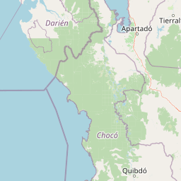
Map view of Paramillo National Natural Park

Use this park location map to pinpoint Paramillo National Natural Park in Colombia, understand its exact geographic position, and read its mapped placement within the surrounding landscape more clearly.

Pigeon | © OpenStreetMap contributors
Park atlas

Map the broader network of protected areas and compare ecological zones within Paramillo's surrounding region.

Explore Adjacent Protected Areas and National Parks Beyond Paramillo National Natural Park

Expand your exploration beyond Paramillo National Natural Park by browsing other protected areas, national parks, and related conservation landscapes in northern Colombia. Comparing these mapped park geographies offers deeper insights into shared Andean páramo ecosystems, cloud forest transitions, and the regional spread of crucial wildlife corridors.
National parkColombia
About 69 km away#1 closest

Southwest

Las Orquídeas National Natural Park: Colombia's Biodiversity Hotspot and Andean Ecosystem Atlas

Explore its unique elevational gradient and protected terrain.

Las Orquídeas National Natural Park in Colombia is renowned for its dramatic elevational range, compressing multiple distinct ecosystems into a single protected area. This national park offers an exceptional view of Andean geography and Chocó biogeographic region biodiversity, transitioning from tropical rainforest to high-altitude páramo. Investigate the mapped landscape and the conservation significance of this unique natural treasure.

Area
287.53 km²
Established
1974
IUCN
II
Relief
Mountain
National parkColombia
About 135 km away#2 closest

Northwest

Los Katíos National Natural Park: Colombia National Park Protected Landscape

Geographic context and mapped terrain for a key Colombian conservation area.

Delve into Los Katíos National Natural Park, a designated National Park in Colombia, to understand its unique protected landscape and its place within the country's broader geography. This detailed view supports atlas exploration, enabling a clear grasp of the park's mapped boundaries and natural terrain for a structured approach to discovering protected areas.

Area
720 km²
Established
1974
IUCN
II
Relief
Mixed relief
National parkDarién Province
About 160 km away#3 closest

West

Darién National Park: Darién Province National Park Geographic and Map Exploration

Discover its protected landscape and regional geographic context.

Darién National Park serves as a key protected area within Darién Province, offering an essential focus for geographic and atlas-based discovery. This dedicated park detail page provides insights into its mapped boundaries and its significance as a national park. Users can explore the park's specific geographic footprint and its place within the regional landscape, facilitating a structured understanding of protected natural areas. Dive into the mapped terrain and conservation landscape context that defines Darién National Park for comprehensive atlas exploration.

Area
5,790 km²
Established
1980
IUCN
II
Relief
Mountain
National parkChocó Department
About 186 km away#4 closest

Southwest

Utría National Natural Park: National Park Protected Landscape and Geography

Explore its mapped boundaries and regional context in Chocó.

As a designated national park, Utría National Natural Park offers a unique lens for understanding Colombia's protected landscapes. This entry provides essential geographic context, detailing the park's location within the Chocó Department and highlighting its significance as a mapped natural area. Discover the protected boundaries and regional landscape character through structured atlas data.

Area
543.8 km²
Established
1987
IUCN
II
Relief
Mountain
Wildlife reserveColombia
About 207 km away#5 closest

Northwest

Playona Acandí Fauna and Flora Sanctuary: Colombia's Wildlife Reserve Atlas and Protected Landscape

Explore protected area boundaries and natural terrain.

Delve into the geographic identity of Playona Acandí Fauna and Flora Sanctuary, a protected wildlife reserve in Colombia. This destination offers detailed mapping of its protected landscape, providing context for its natural terrain and its significance within the national atlas of conservation areas. Understand the specific geographic features that define this important wildlife sanctuary.

Area
262.32 km²
Relief
Lowland
Climate
Tropical
Scope
Mixed
National parkColombia
About 222 km away#6 closest

South

Tatamá National Natural Park: Colombia's Protected Natural Landscape Explorer

Mapped boundaries and regional geography of a Colombian national park.

Tatamá National Natural Park is a protected natural area situated within the Republic of Colombia. As a designated national park, it contributes significantly to the nation's protected lands. This entry provides essential geographic context, focusing on the park's mapped outlines and its role within the broader atlas of Colombian geography. Understanding Tatamá National Natural Park involves appreciating its specific landscape features and its contribution to the country's network of protected natural areas, offering a foundation for regional geographic study.

Area
519 km²
Established
1987
IUCN
II
Relief
Mountain
National parkColombia
About 243 km away#7 closest

South

Los Nevados National Natural Park: Colombia's National Park and Protected Landscape

Detailed map context and protected land geography.

Los Nevados National Natural Park serves as a key protected area within Colombia, offering rich opportunities for geographic discovery. This page details the park's mapped boundaries and its contribution to the broader atlas of South American protected lands. Explore the unique landscape character and regional geographic significance that define Los Nevados National Natural Park as a vital natural reserve.

Area
583 km²
Established
1973
IUCN
II
Visitors
39.9K annual
National parkSantander Department
About 269 km away#8 closest

East

Yariguíes National Park: National Park Geography and Protected Land Atlas

Explore mapped boundaries and regional landscape context.

Yariguíes National Park stands as a crucial protected area within the Santander Department, offering a distinct landscape for geographic study. As a designated national park, it provides vital context for understanding Colombia's protected lands and their regional distribution. This detailed view allows for in-depth exploration of its mapped terrain and natural geography, suitable for atlas-oriented discovery.

Area
788.37 km²
Established
2005
IUCN
II
Scope
Terrestrial

Common questions about visiting, size, designation, and location context for Paramillo National Natural Park

Paramillo National Natural Park FAQs for park facts, access, geography, and protected area context

Find quick answers about Paramillo National Natural Park, including protected-area facts, park geography, trail and visitor context, and how the park fits into its surrounding country and regional landscape.
MoriAtlas Explorer

Continue Your Protected Areas Search Across the Global Atlas

Deepen your exploration by continuing the structured search for national parks and protected areas worldwide. Utilize the comprehensive filtering capabilities to compare different conservation landscapes and refine your understanding of global park geography. Discover more about the distribution and characteristics of protected natural areas.

Global natural geography