Mori Atlas logo
National parkPù Mát National Park

Explore the mapped boundaries and regional geographic identity of this national park.

Pù Mát National Park: Protected Landscape, Geography, and Atlas Context in Nghệ An Province

(Vườn quốc gia Pù Mát)

Pù Mát National Park represents a significant protected natural area within Nghệ An Province, Vietnam. This page offers an atlas-driven exploration of its distinct protected landscape, focusing on its geographic setting and mapped boundaries. Understand how Pù Mát National Park contributes to the regional geography and provides a focal point for discovering protected lands within the Vietnamese atlas.

national parksVietnamNghệ An ProvinceAnnamite mountainsbiodiversity hotspotsendemic species

Pù Mát National Park

National park

Park overview

Structured park overview, official facts, and landscape profile for Pù Mát National Park

Pù Mát National Park park facts, protected area profile, and essential visitor context
Review the core facts for Pù Mát National Park, including designation, size, terrain, visitor scale, habitats, and operating context in one park-focused overview.

About Pù Mát National Park

Pù Mát National Park occupies a strategic position in the Annamite mountain range, a biodiversity-rich area that spans the border between Vietnam and Laos. The park's terrain is characterized by steep slopes, narrow valleys, and elevation gradients that create diverse microhabitats supporting varied ecological communities. The park was formally established in 2001 when the Vietnamese government upgraded the former Pù Mát Preservation Zone to national park status, reflecting recognition of the area's exceptional ecological significance. The Western Nghệ An Biosphere Reserve, which encompasses the park, was designated to promote sustainable development while protecting the region's natural heritage. The park's strict protection zone encompasses the core mountainous areas where human activity is minimized, while the buffer zone allows for sustainable use by local communities. The park's biodiversity value has attracted international conservation attention, with organizations working alongside Vietnamese authorities to study and protect its unique species assemblages.

Quick facts and research context for Pù Mát National Park

Pù Mát National Park is located in Nghệ An Province on Vietnam's North Central Coast, approximately 150 kilometers south of the city of Vinh. The park spans an area of 94,804 hectares, with 89,517 hectares designated as strictly protected zone, 1,596 hectares as ecological recovery area, and 86,000 hectares as buffer zone. Established in November 2001, the park protects a complex mountainous landscape within the Annamite mountain range, home to more than 2,400 plant species and significant populations of globally threatened mammals. The park is particularly notable for housing what may be the only viable population of northern white-cheeked gibbons in the world.

Park context

Deeper park guide and search-rich context for Pù Mát National Park

Pù Mát National Park history, landscape, wildlife, and travel context
Explore Pù Mát National Park through its history, landscape character, ecosystems, wildlife, conservation priorities, cultural context, and seasonal travel timing in a structured park guide built for atlas discovery and search intent.

Why Pù Mát National Park stands out

Pù Mát National Park is best known for its extraordinary mammalian biodiversity, particularly the presence of five Indochinese-endemic species: the northern white-cheeked gibbon, red-shanked douc, saola, Truong Son muntjac, and Annamite striped rabbit. The park contains a substantial population of approximately 455 critically endangered northern white-cheeked crested gibbons, representing two-thirds of the total known population in Vietnam and considered the only confirmed viable population of this subspecies globally. The lowland evergreen forest that covers most of the park supports one of the highest concentrations of threatened mammal species in Vietnam, including the Indochinese tiger, Indian elephant, and Ussuri dhole.

Pù Mát National Park history and protected-area timeline

The formal establishment of Pù Mát National Park came through Decision 174/2001/QĐ-TTg, issued by the Vietnamese Prime Minister on November 8, 2001. This decision upgraded the existing Pù Mát Preservation Zone to national park status, reflecting growing recognition of the area's ecological importance. Prior to national park designation, the area had already received some protection as a preservation zone, but the upgrade acknowledged the need for more comprehensive conservation measures. The park's creation was part of a broader expansion of Vietnam's protected area network during the early 2000s, which aimed to safeguard the country's most biodiverse regions. The establishment also coincided with the designation of the Western Nghệ An Biosphere Reserve, providing an international framework for conservation and sustainable development in the region. Local governance is handled by the People's Committee of Nghệ An Province, which oversees management of the protected area.

Pù Mát National Park landscape and geographic character

The landscape of Pù Mát National Park is dominated by the rugged terrain of the Annamite mountain range, characterized by steep ridgelines, deep valleys, and elevation ranges from lower slopes to significant peaks. The topography creates a complex mosaic of forest types that change with altitude and aspect. The park's terrain includes numerous streams and small rivers that flow through narrow valleys, feeding the broader watershed that supports both wildlife and local communities. The steep slopes that inspired the park's name—Pù Mát meaning "high slope" in Thai—present challenges for human access but also provide natural protection for the forest ecosystems. The landscape's relative remoteness has allowed for the preservation of large tracts of intact forest, making it one of the more significant wilderness areas in northern Vietnam.

Pù Mát National Park ecosystems, habitats, and plant life

The ecological character of Pù Mát is defined by its extensive lowland evergreen forest, which represents the most widespread vegetation type within the park. More than 2,461 plant species have been confirmed within the park boundaries, and ongoing taxonomic research suggests that some of these may represent species new to science. The forest ecosystem supports remarkable biodiversity at multiple levels, from canopy trees to understory plants to forest floor organisms. The combination of elevation variation, relatively intact forest, and proximity to the Laos border has allowed the park to maintain ecological processes that have been lost in many other parts of Vietnam. The park's position within the Western Nghệ An Biosphere Reserve reflects international recognition of these ecological values and provides a framework for regional conservation coordination.

Pù Mát National Park wildlife and species highlights

Pù Mát National Park harbors an exceptional mammalian fauna that makes it one of the most important conservation sites in Vietnam. The park supports five mammal species endemic to the Indochinese region: the northern white-cheeked gibbon, red-shanked douc, saola, Truong Son muntjac, and Annamite striped rabbit. The discovery of approximately 455 northern white-cheeked crested gibbons, representing roughly two-thirds of Vietnam's total population, is particularly significant as this appears to be the only confirmed viable population of this critically endangered subspecies. Beyond the endemic species, the park supports additional globally threatened mammals including Assam macaque, Ussuri dhole, Indochinese tiger, and Indian elephant. The combination of these species, particularly the presence of large mammals like tigers and elephants, indicates a relatively healthy ecosystem with sufficient habitat and prey base to support viable populations.

Pù Mát National Park conservation status and protection priorities

Pù Mát National Park represents a critical node in Vietnam's conservation estate, protecting both species and ecological processes that are increasingly rare in the region. The park's significance is underscored by the presence of multiple globally threatened species and the continued occurrence of species that have been eliminated from most of their former ranges. The conservation value of the park extends beyond its boundaries as part of the Western Nghệ An Biosphere Reserve, which promotes regional approaches to biodiversity protection. The substantial population of northern white-cheeked gibbons has attracted international conservation attention and resources. Management focuses on maintaining the integrity of the strictly protected zone while working with local communities in the buffer zone to promote sustainable land use practices that reduce pressure on the park's resources.

Pù Mát National Park cultural meaning and human context

The landscape of Pù Mát National Park has been inhabited by various ethnic communities whose traditional land use practices have shaped, and been shaped by, the forest environment. The Thai language origin of the park's name reflects the cultural connections between local communities and the mountainous terrain. The region's human history is intertwined with the forest ecosystem, though the establishment of the national park has created frameworks for managing the relationship between local communities and natural resources. The buffer zone surrounding the core protected area includes lands used by local communities for agriculture and other purposes, requiring careful coordination between conservation objectives and livelihood needs.

Top sights and standout views in Pù Mát National Park

Pù Mát National Park protects one of Vietnam's most biodiversity-rich mountainous landscapes, home to a remarkable assemblage of threatened mammals including the critically endangered northern white-cheeked gibbon. The park contains one of the largest remaining areas of lowland evergreen forest in northern Vietnam, supporting more than 2,400 plant species. Five Indochinese-endemic mammal species occur within the park, and the area serves as a critical refuge for species like the saola, which has been rarely observed elsewhere. The park's position within the Western Nghệ An Biosphere Reserve and its proximity to the Laos border make it important for regional conservation coordination.

Best time to visit Pù Mát National Park

The optimal time to visit Pù Mát National Park aligns with the dry season typically running from November to April, when rainfall is reduced and trail conditions are more favorable for exploration. The cooler months from December through February offer comfortable temperatures for hiking and wildlife observation in the mountain environment. Visitors should note that the park's mountainous location means weather conditions can change rapidly, and the wet season from May to October brings heavy rainfall that may affect access to higher elevation areas. Planning a visit should account for the park's remote location and the need for arrangements through Nghệ An Province's tourism infrastructure.

Park location guide

Geography guide, regional context, and park location map for Pù Mát National Park

Pù Mát National Park park geography, regions, and map view in Vietnam
Understand where Pù Mát National Park sits in Vietnam through a broader geographic reading of the surrounding landscape, nearby location context, and its mapped position within the national park landscape.

How Pù Mát National Park fits into Vietnam

Vietnam, officially the Socialist Republic of Viet Nam, is a unitary communist state in Southeast Asia. It occupies roughly 331,000 square kilometres along the eastern edge of Mainland Southeast Asia, with a population exceeding 102 million. The country is bordered by China to the north, Laos and Cambodia to the west, and has maritime boundaries in the Gulf of Thailand and South China Sea.

Wider geography shaping Pù Mát National Park in Vietnam

Vietnam occupies the eastern edge of Mainland Southeast Asia, stretching along the Gulf of Thailand to the southwest and the South China Sea to the east. The country is bordered by China to the north, and Laos and Cambodia to the west. It has a diverse landscape ranging from the Red River Delta in the north to the Mekong Delta in the south.

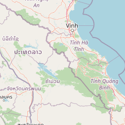
Map view of Pù Mát National Park

Use this park location map to pinpoint Pù Mát National Park in Vietnam, understand its exact geographic position, and read its mapped placement within the surrounding landscape more clearly.

Pigeon | © OpenStreetMap contributors

Location context for Pù Mát National Park

Nghệ An ProvinceNorth Central Coast
Park atlas

Trace the interconnected protected landscapes and conservation areas within Vietnam's Annamite mountain range, offering regional context beyond Pù Mát.

Explore Nearby National Parks and Protected Areas, Expanding Beyond Pù Mát National Park
Explore other national parks and protected areas situated within Vietnam's North Central Coast region, allowing for a broader understanding of the Annamite mountain range's conservation efforts around Pù Mát National Park. This regional overview provides valuable geographic context, highlighting how diverse protected landscapes contribute to a larger network for biodiversity preservation and atlas-style exploration.
National parkHà Tĩnh Province

Vũ Quang National Park: Protected Landscape Identity and Geographic Context in Hà Tĩnh

National Park Discovery and Mapped Terrain Exploration

Investigate Vũ Quang National Park, a key protected area situated in Hà Tĩnh Province. This page provides detailed insight into the park's designation as a national park, focusing on its mapped boundaries, surrounding natural landscapes, and contribution to the regional geography. It serves as a vital resource for understanding the park's protected landscape characteristics and its place within Vietnam's atlas of conservation areas.

Area
550.28 km²
Established
2002
IUCN
II
Relief
Mountain
National parkThanh Hóa Province

Ben En National Park: Vietnam National Park Geography and Mapped Landscape Context

Explore protected area boundaries and regional terrain.

Ben En National Park represents a key protected natural area within Thanh Hóa Province, Vietnam. This detail page facilitates a structured discovery of its geographic features, mapped extent, and its significance as a national park. Dive into the atlas context to understand the park's landscape and its regional setting, offering a factual foundation for geographic exploration.

Area
147.35 km²
Established
1992
IUCN
II
Visitors
6.6K annual
Watercolor illustration of a river flowing through a valley with green forests and distant mountains
National parkVietnam

Phong Nha, Kẻ Bàng National Park: Vietnam's Karst Terrain and Subterranean World

Explore protected landscapes, cave systems, and geological wonders.

Phong Nha, Kẻ Bàng National Park in Vietnam is a globally significant protected landscape, recognized by UNESCO for its exceptional karst topography and extensive cave networks. This national park features dramatic limestone mountains, deep river gorges, and some of the world's most impressive subterranean formations, offering a rich atlas of natural history and geological wonders to explore.

Area
857.54 km²
Established
2001
IUCN
II
Visitors
740K annual
National parkSakon Nakhon Province

Phu Phan National Park: Thailand's Protected Mountain Landscape and Natural Atlas Entry

Explore dry dipterocarp forest and unique terrain in Sakon Nakhon.

Phu Phan National Park offers a detailed look into Thailand's northeastern geography, characterized by its mountainous terrain and extensive dry dipterocarp forests. As a national park, it represents a vital protected landscape within Sakon Nakhon Province, showcasing unique geological formations and providing a rich context for atlas-based exploration. Discover the park's mapped boundaries, its ecological significance, and the distinct natural features that define this prominent Isan region protected area.

Area
665 km²
Established
1972
IUCN
II
Visitors
4.9K annual
National parkSakon Nakhon Province

Phu Pha Yon National Park: Protected Landscape and Regional Geography in Sakon Nakhon Province

Explore the mapped boundaries and natural terrain of this Thai national park.

Phu Pha Yon National Park, situated in Sakon Nakhon Province, is a protected national park offering a focused point for geographic exploration. This park entity serves as a component of Thailand's broader protected area network, with its mapped boundaries and natural landscape providing essential context for regional geography studies. Understanding Phu Pha Yon National Park through its geographic setting and protected status enhances atlas-based discovery and appreciation of its place within the Khorat Plateau.

Area
829 km²
Established
1988
IUCN
II
Visitors
5K annual
Watercolor illustration of a wetland landscape with green trees and a pale sky
National parkNam Định Province

Xuân Thủy National Park: Protected Landscape Identity and Mapped Geography in Nam Định

Explore the national park's protected boundaries and regional landscape.

Xuân Thủy National Park serves as a vital protected landscape within Nam Định Province, Vietnam, offering users a clear point of entry for understanding its geographic identity. This page facilitates detailed exploration of its mapped park boundaries and the surrounding natural terrain, providing essential context for anyone interested in the regional geography of protected areas. Discover the specific landscape characteristics that define this national park and its place within Vietnam's conservation network.

Area
7,100 km²
Established
2003
IUCN
II
Relief
Lowland
National parkPhú Thọ Province

Xuân Sơn National Park: Protected Mountain Landscape and Regional Geography

Mapping the southeastern edge of the Hoang Lien Mountains.

Delve into the protected landscape of Xuân Sơn National Park, a key national park situated in Phú Thọ Province, Vietnam. This area, covering about 150 square kilometers, is defined by its rugged mountainous terrain, featuring steep forested slopes and distinct ridgelines that contribute to the region's varied topography. As a protected national park, Xuân Sơn plays a crucial role in preserving the natural characteristics of the southeastern Hoang Lien Mountains. Its geographic setting is significant, acting as a transition zone between higher montane environments and the nearby lowland river systems, offering a unique perspective on Vietnam's diverse natural heritage.

Area
150.48 km²
Established
1986
IUCN
II
Relief
Mountain
National parkHanoi

Ba Vì National Park: Ancient Volcanic Mountains and Protected Landscape Near Hanoi

Discover the mapped geography and biodiversity of this national park.

Ba Vì National Park, a protected natural area near Hanoi, showcases a dramatic landscape shaped by ancient volcanic activity. The park features three significant peaks, including Vua Mountain, creating a distinct topographical profile. Spanning over 10,800 hectares, it is recognized for its ecological diversity, harboring a wealth of plant and animal species. This national park serves as a vital protected landscape, offering a unique opportunity for geographic exploration and understanding the natural terrain surrounding the Vietnamese capital.

Area
108.15 km²
Established
1991
IUCN
II
Relief
Mountain

Common questions about visiting, size, designation, and location context for Pù Mát National Park

Pù Mát National Park FAQs for park facts, access, geography, and protected area context
Find quick answers about Pù Mát National Park, including protected-area facts, park geography, trail and visitor context, and how the park fits into its surrounding country and regional landscape.
MoriAtlas Explorer

Continue Your Protected Areas Search Across the Global Atlas

Deepen your exploration by continuing the structured search for national parks and protected areas worldwide. Utilize the comprehensive filtering capabilities to compare different conservation landscapes and refine your understanding of global park geography. Discover more about the distribution and characteristics of protected natural areas.

Global natural geography