Mori Atlas logo
National parkPhu Pha Yon National Park

Discover the mapped geography and natural terrain of this significant Thai national park.

Phu Pha Yon National Park: A Protected Landscape in Thailand's Sakon Nakhon Province

Phu Pha Yon National Park represents a key protected area within the northeastern region of Thailand, specifically located in Sakon Nakhon Province. As a designated national park, its geographic boundaries and natural landscapes offer valuable context for atlas-based discovery and understanding of Thailand's conservation lands. This entry provides a focused exploration of Phu Pha Yon National Park's specific geographic footprint and its role within the nation's network of protected areas, supporting a detailed understanding of its mapped terrain.

National ParksThailandIsan RegionPhu Phan RangeHighland EcosystemsSandstone Caves

Phu Pha Yon National Park

National park

Park overview

Structured park overview, official facts, and landscape profile for Phu Pha Yon National Park

Phu Pha Yon National Park park facts, protected area profile, and essential visitor context
Review the core facts for Phu Pha Yon National Park, including designation, size, terrain, visitor scale, habitats, and operating context in one park-focused overview.

About Phu Pha Yon National Park

Phu Pha Yon National Park occupies a significant position in Thailand's protected area system as a highland sanctuary within the Phu Phan Range, a mountain system that runs through the northeastern Isan region. The park's terrain is defined by elevated plateaus and mountainous areas hemmed by higher peaks and sandstone formations that create a distinctive landscape of cliffs, caves, and natural rock architecture. The area serves as an important watershed, with several major local watercourses originating within the park boundaries and flowing outward to support agricultural communities and ecosystems in the surrounding lowlands. The park's establishment in 1988 reflected Thailand's growing commitment to preserving representative samples of its diverse ecological regions, particularly the relatively underexplored highland environments of the northeast. The subsequent renaming from Huai Huad to Phu Pha Yon in 2001 acknowledged the park's distinctive geological character, with 'Phu Pha Yon' translating to referring to the area's cliff and rock formations. The park's strategic location spanning three provinces demonstrates the ecological connectivity of the Phu Phan Range and the importance of trans-boundary conservation in maintaining habitat integrity for species that require large territories or move seasonally across provincial boundaries.

Quick facts and research context for Phu Pha Yon National Park

Phu Pha Yon National Park covers 829 square kilometres across three provinces in Thailand's Isan region. The park was established on July 28, 1988, making it one of Thailand's older national parks. Its terrain consists of highlands within the Phu Phan Range, characterized by elevations between 300 and 600 metres above sea level. The park features numerous caves including Phra Dan Raeng, Hiib Phu Pha Nang, Saowapa, and Phra Wet, many containing ancient geometric rock engravings. The park serves as a critical watershed area, with several main local watercourses originating within its boundaries. The park recorded approximately 5,025 visitors in 2019.

Park context

Deeper park guide and search-rich context for Phu Pha Yon National Park

Phu Pha Yon National Park history, landscape, wildlife, and travel context
Explore Phu Pha Yon National Park through its history, landscape character, ecosystems, wildlife, conservation priorities, cultural context, and seasonal travel timing in a structured park guide built for atlas discovery and search intent.

Why Phu Pha Yon National Park stands out

Phu Pha Yon is best known for its spectacular seasonal wildflower meadows that bloom simultaneously during the rainy season, featuring species such as blackfoot daisy, endemic Utricularia delphinioides, Osbeckia stellata, bladderwort, and sundew. The park's sandstone cave system contains ancient geometric engravings, particularly in Phra Dan Raeng cave. The combination of highland meadows, dramatic cliff formations, and the Dong Noi water reservoir creates a distinctive landscape within Thailand's northeastern protected areas. The park also encompasses Phu Lek Fai, a hill in Dong Luang district associated with local cultural history.

Phu Pha Yon National Park history and protected-area timeline

Phu Pha Yon National Park was established on July 28, 1988, becoming the 57th national park in Thailand and representing one of the earlier designations in the country's modern protected area network. The park was originally named Huai Huad National Park, reflecting its association with the Huai Huad area and reservoir within its boundaries. In 2001, the park was officially renamed Phu Pha Yon National Park, a change that better captured the park's defining geological features and local landscape identity. The park's creation was part of Thailand's broader effort in the late 1980s to establish a comprehensive system of national parks covering representative ecosystems across the country, with particular attention to mountainous and highland areas in the northeastern region that had previously received limited formal protection. The park's management falls under the Department of National Parks, Wildlife and Plant Conservation, which continues to oversee its conservation and visitor services. The park has developed basic visitor infrastructure including a convenience store, eatery, and campsite facilities to support sustainable tourism while generating revenue for park maintenance.

Phu Pha Yon National Park landscape and geographic character

The landscape of Phu Pha Yon National Park is defined by its position within the Phu Phan Range, characterized by mountainous terrain with elevations ranging from 300 to 600 metres above mean sea level. The terrain features highland areas hemmed by higher mountain ranges, with prominent sandstone formations creating dramatic cliff faces, rocky outcrops, and natural rock arches throughout the park. The park contains numerous caves of varying sizes, including Phra Dan Raeng cave, Hiib Phu Pha Nang cave, Saowapa cave, and Phra Wet cave, many featuring geological formations and ancient human modifications. The sandstone mouth formations throughout the park serve as natural water sources and create distinctive visual landmarks against the surrounding forested slopes. The Dong Noi water reservoir provides an important aquatic landscape element within the park, while several other natural and constructed water bodies contribute to the park's hydrological character. The combination of steep cliffs, cave systems, rolling highlands, and water features creates a diverse physical environment that supports multiple habitat types and visual contrasts throughout the seasons.

Phu Pha Yon National Park ecosystems, habitats, and plant life

The ecological character of Phu Pha Yon National Park reflects its position within the Phu Phan Range and the broader ecosystems of Thailand's northeastern highlands. The park's elevation range and varied topography support diverse vegetation communities adapted to highland conditions, including mixed deciduous forest and dry evergreen forest types depending on aspect and moisture availability. The park is particularly notable for its seasonal wildflower displays, where multiple species bloom simultaneously during the rainy season, creating extensive meadows of colour across the highland areas. These include blackfoot daisy, the endemic Utricularia delphinioides, Osbeckia stellata, bladderwort species, and sundew, a carnivorous plant that thrives in the park's moist conditions. The park's function as a watershed area is ecologically significant, with several major watercourses originating within its boundaries and maintaining downstream ecosystems and agricultural water supply. The cave systems provide specialized habitats for species adapted to dark environments, while the reservoir areas support aquatic biodiversity. The combination of forested slopes, open meadows, cave environments, and aquatic habitats creates a mosaic of ecological conditions within the park's boundaries.

Phu Pha Yon National Park wildlife and species highlights

Phu Pha Yon National Park supports several notable mammal species typical of Thailand's northeastern highland forests. Barking deer and sambar deer are present throughout the park, occupying forest edges and more open areas where forage is available. Wild boar are found in various parts of the park, often near water sources and in areas with sufficient ground cover. The dhole, also known as the Asian wild dog, is present in the park, representing a predator species that requires intact ecosystems and adequate prey populations to sustain viable populations. The park supports diverse birdlife, with numerous species exploiting the variety of habitats from forest canopy to open meadows and water bodies. The wildflower meadows during the rainy season attract various insect pollinators and other invertebrates that play important ecological roles in the park's food webs. While the Wikipedia source provides a foundation for understanding the park's wildlife, comprehensive species inventories for this protected area would require additional specialized sources.

Phu Pha Yon National Park conservation status and protection priorities

Phu Pha Yon National Park contributes to Thailand's protected area network as an IUCN Category II national park, reflecting its primary purpose of protecting natural ecosystems while allowing managed visitor access. The park's designation within the Phu Phan Range helps preserve connectivity across a mountain system that supports important ecological processes and species movements across broader landscapes. The park's watershed function is particularly significant for downstream communities in Sakon Nakhon, Nakhon Phanom, and Mukdahan provinces, where water from the park's headwaters supports agriculture and domestic use. The protection of the park's cave systems with their ancient engravings adds a cultural conservation dimension to the area's protected status. The presence of endemic species such as Utricularia delphinioides within the park highlights its significance for plant conservation, as endemic taxa face heightened vulnerability to habitat disturbance and climate change. The park's visitor management, including entrance fee structures and designated camping areas, represents an attempt to balance conservation with sustainable tourism that generates resources for ongoing protection and management.

Phu Pha Yon National Park cultural meaning and human context

Phu Pha Yon National Park exists within a region of rich cultural significance in Thailand's Isan heartland. The park spans areas associated with the Phu Thai ethnic communities, whose traditional territories extend across portions of Sakon Nakhon, Nakhon Phanom, and Mukdahan provinces. The park contains several caves with ancient geometric rock engravings, notably in Phra Dan Raeng cave, representing evidence of human presence and cultural expression in the area predating modern protected area designation. The landscape holds local significance beyond its ecological value, with features like Phu Lek Fai in Dong Luang district associated with regional history and community memory. The park's name itself, Phu Pha Yon, reflects local naming conventions describing the area's characteristic cliff and rock formations. Multiple watercourses originating within the park have supported human settlement and agricultural activity in the surrounding lowlands for generations, creating reciprocal relationships between the highland environment and valley communities that continue today.

Top sights and standout views in Phu Pha Yon National Park

Phu Pha Yon National Park offers a distinctive combination of geological, ecological, and cultural features that set it apart within Thailand's northeastern protected areas. The simultaneous bloom of multiple wildflower species during the rainy season creates one of the park's most memorable visual experiences, with meadows carpeted in blackfoot daisy, endemic bladderwort, and sundew. The cave systems, particularly Phra Dan Raeng cave with its ancient geometric engravings, provide windows into the human history of this landscape and add cultural depth to the visitor experience. The dramatic sandstone cliffs and rock formations throughout the park create scenic viewpoints and photographic opportunities, while the Dong Noi water reservoir offers a contrasting aquatic landscape. The park's position within the Phu Phan Range provides access to highland environments that differ markedly from the more commonly visited lowland and coastal protected areas of central and southern Thailand, offering visitors an introduction to the distinctive character of Isan's mountainous landscapes.

Best time to visit Phu Pha Yon National Park

The most visually spectacular time to visit Phu Pha Yon National Park coincides with the rainy season, when the park's wildflower meadows reach their full expression with simultaneous blooming of multiple species including blackfoot daisy, bladderwort, and sundew. This period typically spans the months of the Thai rainy season, creating lush green landscapes throughout the park as moisture revives vegetation across the highlands. The wet season also ensures that waterfalls, streams, and the reservoir are at their most impressive, while temperatures are moderated by cloud cover and precipitation. The dry season offers different advantages, with easier access to trails and more predictable visibility for sightseeing, though the landscape may appear more subdued as vegetation dries. Visitors interested in cave exploration can appreciate these formations year-round, though waterproof footwear is advisable during the wet season when cave floors may be damp. The park's facilities including the campsite operate throughout the year, though visitors should check current conditions before planning overnight stays.

Park location guide

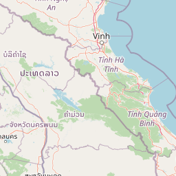
Geography guide, regional context, and park location map for Phu Pha Yon National Park

Phu Pha Yon National Park park geography, regions, and map view in Thailand
Understand where Phu Pha Yon National Park sits in Thailand through a broader geographic reading of the surrounding landscape, nearby location context, and its mapped position within the national park landscape.

How Phu Pha Yon National Park fits into Thailand

Thailand is a Southeast Asian nation formerly called Siam, located in mainland Southeast Asia. It operates as a unitary parliamentary constitutional monarchy under King Vajiralongkorn. The country borders Myanmar, Laos, Cambodia, and Malaysia, with maritime boundaries involving Vietnam, Indonesia, and India. Thailand has a population of nearly 66 million and covers approximately 513,120 km². Historically, the Sukhothai Kingdom marks the beginning of Thai history, followed by the powerful Ayutthaya Kingdom.

Wider geography shaping Phu Pha Yon National Park in Thailand

Thailand occupies mainland Southeast Asia with borders to Myanmar (west/northwest), Laos (east/northeast), Cambodia (southeast), and Malaysia (south). The country has coastline along the Gulf of Thailand to the southeast and the Andaman Sea to the southwest. The territory covers approximately 513,120 km².

Map view of Phu Pha Yon National Park

Use this park location map to pinpoint Phu Pha Yon National Park in Thailand, understand its exact geographic position, and read its mapped placement within the surrounding landscape more clearly.

Pigeon | © OpenStreetMap contributors

Location context for Phu Pha Yon National Park

Mukdahan ProvinceNakhon Phanom ProvinceSakon Nakhon Province
Park atlas

Explore connected highland ecosystems and sandstone landscapes across Thailand's Phu Phan Range.

Discover Related National Parks and Protected Areas Near Phu Pha Yon National Park
Continue your park exploration by browsing other national parks and protected areas within Thailand's Isan Region, particularly those across the broader Phu Phan Range. This allows you to trace shared geological features, compare diverse highland ecosystems, and understand regional conservation efforts beyond Phu Pha Yon National Park.
National parkSakon Nakhon Province

Phu Phan National Park: Thailand's Protected Mountain Landscape and Natural Atlas Entry

Explore dry dipterocarp forest and unique terrain in Sakon Nakhon.

Phu Phan National Park offers a detailed look into Thailand's northeastern geography, characterized by its mountainous terrain and extensive dry dipterocarp forests. As a national park, it represents a vital protected landscape within Sakon Nakhon Province, showcasing unique geological formations and providing a rich context for atlas-based exploration. Discover the park's mapped boundaries, its ecological significance, and the distinct natural features that define this prominent Isan region protected area.

Area
665 km²
Established
1972
IUCN
II
Visitors
4.9K annual
National parkMukdahan Province

Phu Pha Thoep National Park: Mukdahan Province Protected National Park Geography

Explore its mapped protected landscape and regional context.

Phu Pha Thoep National Park is a designated national park in Thailand's Mukdahan Province, offering a distinct focus for geographic exploration. This resource provides detailed insights into its protected landscape, outlining mapped park boundaries and its integration within the regional geography. Understand the park's specific natural terrain and its value for structured atlas-style discovery, moving beyond simple location data to grasp its protected area significance.

Area
48 km²
IUCN
II
Visitors
47.6K annual
Relief
Upland
National parkAmnat Charoen Province

Phu Sa Dok Bua National Park: National Park with Mapped Protected Boundaries

Explore protected landscapes in Amnat Charoen Province, Thailand.

Discover Phu Sa Dok Bua National Park, a designated national park situated within the geographic context of Amnat Charoen Province. This profile focuses on the park's protected area identity and its mapped boundaries, offering essential geographic information for atlas-based exploration and understanding its role within Thailand's conservation landscape.

Area
231 km²
Established
1992
IUCN
II
Visitors
1.8K annual
National parkKhon Kaen Province

Phu Kao, Phu Phan Kham National Park: Mapped Boundaries and Regional Geographic Context in Thailand

Explore the protected natural landscape of Khon Kaen Province.

Phu Kao, Phu Phan Kham National Park offers an essential anchor for geographic exploration within Thailand's Khon Kaen Province. This national park serves as a focal point for understanding mapped protected areas, their boundaries, and the surrounding natural terrain. As a key element of the Isan region's geography, it provides a concrete example for regional landscape analysis and atlas-based discovery of northeastern Thailand's protected territories.

Area
318 km²
Established
1985
IUCN
II
Visitors
4.3K annual
Green fields, trees, and pink-hued mountains in a watercolor landscape
National parkKhon Kaen Province

Nam Phong National Park: Mapped Protected Landscape and Geography in Khon Kaen Province

Explore scenic viewpoints, rock formations, and reservoir landscapes.

Nam Phong National Park presents a compelling case study in protected landscape geography, particularly within Thailand's northeastern region. This national park is defined by its mountainous terrain, featuring the Phu Phan Kham and Phu Meng ranges that dramatically meet the waters of the Ubol Ratana Dam reservoir. Its mapped boundaries encompass striking viewpoints like Hin Chang Si, prehistoric rock paintings, and geological formations, offering a detailed look at its natural and archaeological significance for atlas exploration.

Area
197 km²
Established
2000
IUCN
II
Visitors
68.3K annual
National parkKhon Kaen Province

Phu Wiang National Park: Detailed Protected Landscape and Regional Geographic Context

Explore mapped park boundaries and natural terrain in Khon Kaen Province.

Phu Wiang National Park serves as a vital component of Thailand's protected areas network, situated within the geographic landscape of Khon Kaen Province. This entry facilitates a detailed atlas-style examination of the park's identity as a national park, focusing on its geographic footprint and the surrounding regional context. Users can trace the protected landscape's features and understand its place within the broader mapped terrain of northeastern Thailand.

Area
325 km²
Established
1965
IUCN
II
Visitors
6.2K annual
National parkHà Tĩnh Province

Vũ Quang National Park: Protected Landscape Identity and Geographic Context in Hà Tĩnh

National Park Discovery and Mapped Terrain Exploration

Investigate Vũ Quang National Park, a key protected area situated in Hà Tĩnh Province. This page provides detailed insight into the park's designation as a national park, focusing on its mapped boundaries, surrounding natural landscapes, and contribution to the regional geography. It serves as a vital resource for understanding the park's protected landscape characteristics and its place within Vietnam's atlas of conservation areas.

Area
550.28 km²
Established
2002
IUCN
II
Relief
Mountain
National parkThailand

Phu Pha Man National Park: Dramatic Cliffs, Caves, and Dinosaur Tracks in Thailand's Protected Landscape

Explore mapped geography and prehistoric fossil sites within Thailand's Phu Pha Man National Park.

Phu Pha Man National Park is a protected area in Thailand distinguished by its rugged limestone formations, significant cave networks, and dramatic waterfalls. Beyond its scenic beauty, the park is a globally important site for paleontology, holding Asia's oldest known dinosaur tracks. This page provides an atlas-style view of its protected landscape, local geography, and the unique prehistoric discoveries that define its identity.

Area
350 km²
Established
2000
IUCN
II
Visitors
9.7K annual

Common questions about visiting, size, designation, and location context for Phu Pha Yon National Park

Phu Pha Yon National Park FAQs for park facts, access, geography, and protected area context
Find quick answers about Phu Pha Yon National Park, including protected-area facts, park geography, trail and visitor context, and how the park fits into its surrounding country and regional landscape.
MoriAtlas Explorer

Continue Your Protected Areas Search Across the Global Atlas

Deepen your exploration by continuing the structured search for national parks and protected areas worldwide. Utilize the comprehensive filtering capabilities to compare different conservation landscapes and refine your understanding of global park geography. Discover more about the distribution and characteristics of protected natural areas.

Global natural geography