

Mori Atlas logo
National parkPhu Wiang National Park

Discover the mapped protected area boundaries and natural landscape context.

Phu Wiang National Park: A Protected National Park within Khon Kaen Province's Geography

Phu Wiang National Park represents a key protected landscape within the geography of Khon Kaen Province, northeastern Thailand. This page provides structured discovery for the park's identity as a national park, offering insights into its mapped boundaries and its role within the region's atlas context. Users can explore the fundamental geographic and protected-area characteristics that define this significant natural space.

Dinosaur fossilsKhorat PlateauNational parkPaleontological siteNortheastern ThailandMountain landscape

Phu Wiang National Park

National park

Park overview

Structured park overview, official facts, and landscape profile for Phu Wiang National Park

Phu Wiang National Park park facts, protected area profile, and essential visitor context
Review the core facts for Phu Wiang National Park, including designation, size, terrain, visitor scale, habitats, and operating context in one park-focused overview.

About Phu Wiang National Park

Phu Wiang National Park protects a distinctive landscape in northeastern Thailand where natural beauty meets paleontological significance. The park encompasses the Phu Wiang Mountains within Khon Kaen Province, an area characterized by a remarkable geological structure of two concentric mountain ranges forming a circular basin. This formation creates a landscape where steep to moderately sloped hills surround a central depression, with the terrain channeling visitors through a landscape shaped by over 200 million years of geological history. The Khorat Plateau setting provides the park with its characteristic red sandstone and sedimentary geology, often called Khorat stone, which has proven instrumental in preserving the dinosaur fossils that define the park's international reputation. Beyond its fossil sites, the park supports multiple waterfalls, forest areas, and serves as the upstream source for several important waterways including Huai Sai Khao, which flows into the Nam Phong system. The combination of accessible natural scenery, significant scientific discoveries, and the on-site museum makes Phu Wiang uniquely positioned among Thailand's protected areas.

Quick facts and research context for Phu Wiang National Park

Phu Wiang National Park occupies 325 square kilometres in Khon Kaen Province, approximately 85 kilometres northwest of Khon Kaen city. The park was officially established as Thailand's 63rd national park in 1991, though the area received protection attention following the initial dinosaur discoveries in the 1970s. The terrain consists of a basin surrounded by two mountain ranges, with elevation ranging from 210 meters to 844 meters above sea level. The park is managed by Thailand's Department of National Parks, Wildlife and Plant Conservation and received approximately 6,150 visitors in 2019. The region sits on the Khorat Plateau, characterized by thick red sedimentary rock formations that have created ideal conditions for fossil preservation.

Park context

Deeper park guide and search-rich context for Phu Wiang National Park

Phu Wiang National Park history, landscape, wildlife, and travel context
Explore Phu Wiang National Park through its history, landscape character, ecosystems, wildlife, conservation priorities, cultural context, and seasonal travel timing in a structured park guide built for atlas discovery and search intent.

Why Phu Wiang National Park stands out

Phu Wiang National Park is globally renowned for its exceptional dinosaur fossil discoveries. The park contains multiple dinosaur excavation sites where paleontologists have unearthed significant specimens, most notably the 1996 discovery of Siamotyrannus isanensis, a carnivorous dinosaur representing a newly identified family. The park features four accessible dinosaur dig sites, including locations at Phu Pratu Ti Ma, Thua Jia Cave, Huai Pratu Ti Ma, and Hin Lat Yai. The on-site Phu Wiang Dinosaur Museum displays many of these discoveries, making the park a premier destination for understanding Thailand's prehistoric past. The concentration and diversity of dinosaur remains found here ranks among the most significant in Southeast Asia.

Phu Wiang National Park history and protected-area timeline

The area that now comprises Phu Wiang National Park first gained international attention in approximately 1976 when local researchers discovered dinosaur footprints and fossilized bones in the region. These discoveries marked the first identification of dinosaur remains in Thailand and sparked ongoing scientific interest in the Khorat Plateau. Following these initial findings, systematic excavation and research uncovered additional specimens, including the significant 1996 discovery of Siamotyrannus isanensis, a theropod dinosaur representing both a new species and potentially a new family within the carnivorous dinosaur classification. The park was formally established as Thailand's 63rd national park on June 24, 1991, formalizing protection for this paleontologically significant landscape. The Phu Wiang Dinosaur Museum was subsequently developed within the park to house and display the archaeological findings, providing educational context for visitors. The establishment of the park balanced conservation of the fossil sites with sustainable access, making the discoveries available for both scientific study and public education.

Phu Wiang National Park landscape and geographic character

The topography of Phu Wiang National Park presents a distinctive circular mountain formation surrounding a central basin, creating a natural amphitheater-like structure. Two concentric mountain ranges define the park's boundaries: the outer range features the highest peaks, reaching 844 meters above sea level in the southwestern portion, while the inner range achieves elevations up to 470 meters, particularly in areas where dinosaur fossils have been concentrated. The central basin consists of relatively flat to gently rolling terrain, providing a stark contrast to the surrounding ridges. The park sits atop the Khorat Plateau, a geological formation characterized by remarkably thick sedimentary layers exceeding 4,000 meters. These red-colored sediments, known locally as Khorat stone, include distinct rock units such as Khao Phra Wihan, Phu Phan stone, and Khok gravel formations. The landscape also features numerous streams and waterways originating from the park's upland areas, with Huai Sai Khao serving as a primary watershed feeding into the larger Nam Phong River system.

Phu Wiang National Park ecosystems, habitats, and plant life

The ecosystems within Phu Wiang National Park reflect the transitional nature of northeastern Thailand's environment. The park's forest cover varies with elevation and topography, transitioning from mixed deciduous forest in lower areas to evergreen vegetation along watercourses and in protected valleys. The central basin and lower slopes support grassland and scrubland communities typical of the Khorat Plateau. The waterways and riparian zones harbor distinct plant assemblages adapted to seasonal moisture variations. The geological setting on the Khorat Plateau creates specific soil and substrate conditions that influence vegetation patterns across the park. While the paleontological discoveries represent the park's most famous natural heritage, the living ecosystems support biodiversity across multiple habitat types, from hill forest to wetland areas associated with the stream systems draining the basin.

Phu Wiang National Park wildlife and species highlights

The wildlife community in Phu Wiang National Park reflects the park's position in northeastern Thailand's forest ecosystems. Bird species recorded in the park include the black-crested bulbul, lineated barbet, Siamese fireback (Thailand's national bird), Eurasian jay, common flameback, green-billed malkoha, rufescent prinia, and shikra. The mammal population consists primarily of smaller species given the park's lack of large predator populations. Notable species include the slow loris, masked palm civet, lesser mouse deer, barking deer (muntjac), Himalayan porcupine, fishing cat, large Indian civet, and small Indian civet. The mix of forest, grassland, and wetland habitats supports this diversity of fauna, though the dinosaur sites themselves do not support significant contemporary wildlife populations due to their geological nature.

Phu Wiang National Park conservation status and protection priorities

Phu Wiang National Park represents Thailand's commitment to preserving both geological heritage and natural ecosystems. The park's designation as a national park in 1991 formalized protection for an area of significant paleontological value, ensuring that dinosaur fossil sites remain preserved for ongoing scientific research and public education. The Khorat Plateau environment faces ongoing pressures from agricultural expansion and development, making protected area status critical for maintaining ecological processes and watershed function. The park's role as a headwater source for multiple stream systems extends its conservation importance beyond its boundaries, protecting water quality and flow for downstream communities. The presence of the Phu Wiang Dinosaur Museum within the park demonstrates how conservation and education interconnect, allowing visitors to appreciate the scientific significance while minimizing impact on actual dig sites.

Phu Wiang National Park cultural meaning and human context

The Phu Wiang region has historical human presence that predates modern conservation efforts, though the area is primarily known for its natural and paleontological significance rather than extensive cultural heritage sites. Local communities in Khon Kaen Province maintain connections to the landscape surrounding the park, with agricultural activities historically occurring in the lower elevation areas. The dinosaur discoveries, while representing prehistoric life, have become embedded in local identity, with the museum and fossil sites serving as points of regional pride. The park's location on the Khorat Plateau places it within a region of northeastern Thailand known for distinctive cultural traditions and historical development patterns different from central Thailand.

Top sights and standout views in Phu Wiang National Park

Phu Wiang National Park offers a combination of scientific discovery and natural scenery uncommon among Thailand's protected areas. The dinosaur excavation sites, particularly the four accessible dig locations, provide tangible connections to prehistoric life and represent Thailand's most significant paleontological finds. The on-site museum presents these discoveries in an educational context, making the scientific findings accessible to general visitors. The landscape itself, with its concentric mountain ranges and central basin, provides scenic variety within a relatively compact area. Waterfalls including Namtok Saeng Chan and multiple other cascades add to the park's natural attractions. The blend of geological significance, accessible fossils, museum facilities, and forest scenery creates a park experience distinct from typical Thai national parks focused primarily on contemporary ecosystems.

Best time to visit Phu Wiang National Park

The optimal time to visit Phu Wiang National Park corresponds to Thailand's cool dry season from November through February, when temperatures are most comfortable for outdoor exploration, ranging from around 16°C to 25°C. This period coincides with the winter monsoon season, producing clear skies and minimal rainfall that facilitate access to trail areas and outdoor sites. The hot summer months from March to April bring higher temperatures reaching 36°C or more, making midday activities challenging. The rainy season from May through October delivers the majority of the park's approximately 1,199mm annual rainfall, which can affect trail conditions and visibility but also enhances waterfall flows and landscape greenery. Visitor numbers remain modest throughout the year, with approximately 6,150 annual visits suggesting that crowds are rarely a significant factor in planning.

Park location guide

Geography guide, regional context, and park location map for Phu Wiang National Park

Phu Wiang National Park park geography, regions, and map view in Thailand
Understand where Phu Wiang National Park sits in Thailand through a broader geographic reading of the surrounding landscape, nearby location context, and its mapped position within the national park landscape.

How Phu Wiang National Park fits into Thailand

Thailand is a Southeast Asian nation formerly called Siam, located in mainland Southeast Asia. It operates as a unitary parliamentary constitutional monarchy under King Vajiralongkorn. The country borders Myanmar, Laos, Cambodia, and Malaysia, with maritime boundaries involving Vietnam, Indonesia, and India. Thailand has a population of nearly 66 million and covers approximately 513,120 km². Historically, the Sukhothai Kingdom marks the beginning of Thai history, followed by the powerful Ayutthaya Kingdom.

Wider geography shaping Phu Wiang National Park in Thailand

Thailand occupies mainland Southeast Asia with borders to Myanmar (west/northwest), Laos (east/northeast), Cambodia (southeast), and Malaysia (south). The country has coastline along the Gulf of Thailand to the southeast and the Andaman Sea to the southwest. The territory covers approximately 513,120 km².

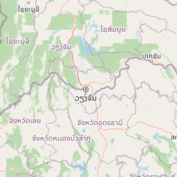
Map view of Phu Wiang National Park

Use this park location map to pinpoint Phu Wiang National Park in Thailand, understand its exact geographic position, and read its mapped placement within the surrounding landscape more clearly.

Pigeon | © OpenStreetMap contributors

Location context for Phu Wiang National Park

Khon Kaen Province
Park atlas

Compare Nearby Protected Landscapes and Trace Regional Park Geography in Northeastern Thailand

Explore Other National Parks and Protected Areas Near Phu Wiang National Park
After exploring Phu Wiang National Park's unique paleontological sites and mountain landscapes, browse a curated selection of other national parks and protected areas across Northeastern Thailand. This atlas view allows for geographic comparison, revealing how conservation efforts extend through the Khorat Plateau and its diverse regional terrain.
Green fields, trees, and pink-hued mountains in a watercolor landscape
National parkKhon Kaen Province

Nam Phong National Park: Mapped Protected Landscape and Geography in Khon Kaen Province

Explore scenic viewpoints, rock formations, and reservoir landscapes.

Nam Phong National Park presents a compelling case study in protected landscape geography, particularly within Thailand's northeastern region. This national park is defined by its mountainous terrain, featuring the Phu Phan Kham and Phu Meng ranges that dramatically meet the waters of the Ubol Ratana Dam reservoir. Its mapped boundaries encompass striking viewpoints like Hin Chang Si, prehistoric rock paintings, and geological formations, offering a detailed look at its natural and archaeological significance for atlas exploration.

Area
197 km²
Established
2000
IUCN
II
Visitors
68.3K annual
National parkKhon Kaen Province

Phu Kao, Phu Phan Kham National Park: Mapped Boundaries and Regional Geographic Context in Thailand

Explore the protected natural landscape of Khon Kaen Province.

Phu Kao, Phu Phan Kham National Park offers an essential anchor for geographic exploration within Thailand's Khon Kaen Province. This national park serves as a focal point for understanding mapped protected areas, their boundaries, and the surrounding natural terrain. As a key element of the Isan region's geography, it provides a concrete example for regional landscape analysis and atlas-based discovery of northeastern Thailand's protected territories.

Area
318 km²
Established
1985
IUCN
II
Visitors
4.3K annual
National parkThailand

Phu Pha Man National Park: Dramatic Cliffs, Caves, and Dinosaur Tracks in Thailand's Protected Landscape

Explore mapped geography and prehistoric fossil sites within Thailand's Phu Pha Man National Park.

Phu Pha Man National Park is a protected area in Thailand distinguished by its rugged limestone formations, significant cave networks, and dramatic waterfalls. Beyond its scenic beauty, the park is a globally important site for paleontology, holding Asia's oldest known dinosaur tracks. This page provides an atlas-style view of its protected landscape, local geography, and the unique prehistoric discoveries that define its identity.

Area
350 km²
Established
2000
IUCN
II
Visitors
9.7K annual
National parkLoei Province

Phu Kradueng National Park: Sandstone Mesa Protected Landscape and Geographic Atlas

Discover mapped boundaries and pine savanna terrain.

Phu Kradueng National Park, situated in Loei Province, Thailand, is a remarkable protected area defined by its large sandstone mesa and striking cliff-edged summit plateau. This page offers detailed geographic insights into the park's unique landscape, including its pine savanna ecosystems, diverse forest types transitioning from lower slopes to the summit, and its cool, refreshing climate. Explore Phu Kradueng National Park's mapped boundaries and natural terrain for a deeper understanding of this significant conservation landscape.

Area
348 km²
Established
1962
IUCN
II
Visitors
86.3K annual
National parkThailand

Tat Ton National Park: Thailand's National Park Geography and Mapped Landscape

Explore its protected boundaries and natural terrain.

Delve into the specifics of Tat Ton National Park, a protected natural area in Thailand. This page provides a detailed exploration of its mapped boundaries, regional geography, and the character of its natural terrain. Understand its value as a national park for understanding the distribution of protected landscapes and how they contribute to the overall geographic context of Thailand.

Area
217 km²
Established
1980
IUCN
II
Visitors
388.7K annual
National parkPhetchabun Province

Nam Nao National Park: Protected Landscape and Regional Geography

Explore maps and natural terrain of this Northern Thailand park.

Nam Nao National Park, situated in Phetchabun Province, Thailand, is a large national park distinguished by its rugged mountainous terrain and extensive pine forest landscapes. This protected area is vital for its role in conservation, housing significant biodiversity and forming a natural boundary between regions. Through its mapped geography and diverse natural settings, Nam Nao National Park offers a key destination for understanding protected land dynamics and regional natural landscapes.

Area
966 km²
Established
1972
IUCN
II
Visitors
31.8K annual
National parkPhetchabun Province

Tat Mok National Park: A National Park within Phetchabun Province's Mapped Landscapes

Exploring its protected land and regional geographic context.

Tat Mok National Park is a designated national park offering rich opportunities for geographic discovery. Situated in Thailand's Phetchabun Province, this protected area contributes to the region's atlas of natural landscapes. Users can explore the mapped boundaries and understand the park's place within the broader geography of Phetchabun, highlighting its role as a conservation landscape within Thailand.

Area
290 km²
Established
1998
IUCN
II
Visitors
17.9K annual
National parkChaiyaphum Province

Sai Thong National Park: Protected National Park in Chaiyaphum Province's Geography

Explore mapped landscape and protected area context.

Sai Thong National Park is a designated national park located in Chaiyaphum Province, Thailand, contributing to the region's extensive network of protected areas. Its protected landscape identity is shaped by the geography of northeastern Thailand, offering a unique focus for map-based discovery and understanding the distribution of natural areas. Explore the mapped terrain and regional context of this significant natural landmark.

Area
319 km²
Established
1992
IUCN
II
Visitors
51.2K annual

Common questions about visiting, size, designation, and location context for Phu Wiang National Park

Phu Wiang National Park FAQs for park facts, access, geography, and protected area context
Find quick answers about Phu Wiang National Park, including protected-area facts, park geography, trail and visitor context, and how the park fits into its surrounding country and regional landscape.
MoriAtlas Explorer

Continue Your Protected Areas Search Across the Global Atlas

Deepen your exploration by continuing the structured search for national parks and protected areas worldwide. Utilize the comprehensive filtering capabilities to compare different conservation landscapes and refine your understanding of global park geography. Discover more about the distribution and characteristics of protected natural areas.

Global natural geography