

Mori Atlas logo
National parkSai Thong National Park

Discover the geographic identity and protected area boundaries of Sai Thong National Park.

Sai Thong National Park: Mapped Protected Landscape in Chaiyaphum Province

Sai Thong National Park represents a significant protected natural area within the northeastern Thai province of Chaiyaphum. Situated within a region known for its mountain ranges and extensive forest cover, this national park offers a focal point for understanding Thailand's protected lands. Explore its geographic setting and mapped landscape context to appreciate its role in the nation's conservation atlas.

National ParksThailandMountain ParksForest ProtectionFlower FieldsWaterfalls

Sai Thong National Park

National park

Park overview

Structured park overview, official facts, and landscape profile for Sai Thong National Park

Sai Thong National Park park facts, protected area profile, and essential visitor context
Review the core facts for Sai Thong National Park, including designation, size, terrain, visitor scale, habitats, and operating context in one park-focused overview.

About Sai Thong National Park

Sai Thong National Park represents an important protected area in Thailand's northeastern region, encompassing diverse ecosystems within the Phang Hoei mountain range. The park's terrain is predominantly mountainous, with elevations ranging from the lower foothills to the summit of Khao Phang Hoei at 1,008 meters. This elevation gradient supports a variety of habitat types, from mixed deciduous forests in the lower elevations to dry evergreen forests in more sheltered valleys and slopes. The park's hydrological significance is substantial, as numerous tributaries originating within its boundaries contribute to the broader Chi River watershed, supporting both ecological functions and downstream water resources. Beyond its ecological value, the park serves as a destination for visitors interested in mountain scenery, nature photography, and the experience of seasonal wildflower displays. The landscape offers several viewpoints from which visitors can appreciate the extent of the protected area and the surrounding regional topography.

Quick facts and research context for Sai Thong National Park

Sai Thong National Park covers an area of 319 square kilometers in Chaiyaphum Province, northeastern Thailand. The park was officially established on December 30, 1992, and is managed by Thailand's Department of National Parks, Wildlife and Plant Conservation. The park lies within the Phang Hoei mountain range, with its highest point at Khao Phang Hoei at 1,008 meters elevation. The protected area encompasses mixed deciduous, dipterocarp, and dry evergreen forest communities, with numerous streams and tributaries feeding into the Chi River system. Visitor numbers reached approximately 51,233 in 2019. The park is known for its seasonal flower fields, waterfalls, and scenic mountain viewpoints.

Park context

Deeper park guide and search-rich context for Sai Thong National Park

Sai Thong National Park history, landscape, wildlife, and travel context
Explore Sai Thong National Park through its history, landscape character, ecosystems, wildlife, conservation priorities, cultural context, and seasonal travel timing in a structured park guide built for atlas discovery and search intent.

Why Sai Thong National Park stands out

Sai Thong National Park is best known for its spectacular seasonal flower fields, particularly the krachiao blossoms that bloom across the landscape, creating vibrant displays of color. The park also features several waterfalls and scenic viewpoints that attract visitors seeking to experience the natural beauty of Thailand's northeastern highlands. The combination of mountainous terrain, diverse forest types, and seasonal wildflower blooms distinguishes this park from other protected areas in the region. The Siam tulip, known locally as Curcuma alismatifolia, is another botanical highlight that draws attention during its flowering season.

Sai Thong National Park history and protected-area timeline

Sai Thong National Park was officially established on December 30, 1992, becoming part of Thailand's national park system administered by the Department of National Parks, Wildlife and Plant Conservation. The establishment of the park brought formal protection to the forests and landscapes of the Phang Hoei mountain range, but it also created significant challenges for communities that had previously lived within the area. Following the park's creation, indigenous forest dwellers who had inhabited the region for generations found their traditional lands and dwellings incorporated into the protected area, leading to complex social and legal conflicts. These communities, whose ancestors lived in the area before the formation of modern Thailand, became subject to criminal penalties for remaining on lands now designated as protected. In 2018, a notable legal case resulted in 14 cassava-growing peasants, nine of them women, being found guilty of encroachment on Sai Thong National Park after refusing to leave lands they had occupied since the 1970s, prior to the park's establishment. The tension between conservation goals and the rights of long-term inhabitants reflects broader challenges in Thailand's approach to protected area management.

Sai Thong National Park landscape and geographic character

The landscape of Sai Thong National Park is defined by its mountainous character within the Phang Hoei Range. The terrain features steep slopes, ridgelines, and valleys that create a visually diverse topography. The park's highest point, Khao Phang Hoei, rises to 1,008 meters and provides commanding views over the surrounding landscape. Numerous streams and small rivers have carved valleys through the mountainous terrain, creating cascading water features and feeding the broader drainage network that eventually connects to the Chi River. The forest cover varies with elevation and aspect, with mixed deciduous and dipterocarp forests dominating lower slopes while dry evergreen forests persist in moisture-retaining valleys and shady areas. The seasonal appearance of wildflower fields, particularly during the krachiao blooming period, adds a distinctive visual element to the landscape, transforming sections of the park into colorful meadows that contrast with the surrounding forest and mountain backdrop.

Sai Thong National Park ecosystems, habitats, and plant life

The forest ecosystems within Sai Thong National Park represent a blend of vegetation types characteristic of northeastern Thailand's mountainous areas. The mixed deciduous forest communities include species that lose their leaves during the dry season, creating seasonal changes in the forest's appearance. Dipterocarp forests, which are typical of Southeast Asian lowland and lower montane areas, also occur within the park, featuring trees from the Dipterocarpaceae family that often dominate forest canopies. The dry evergreen forest type is found in areas with more consistent moisture availability, such as valley floors and north-facing slopes, and maintains green foliage throughout the year. This mosaic of forest types supports biodiversity by providing varied habitats across the elevational gradient. The park's streams and tributaries also contribute to the ecological diversity, creating riparian corridors and aquatic habitats within the broader terrestrial landscape.

Sai Thong National Park wildlife and species highlights

While the source material does not provide detailed species lists for Sai Thong National Park, the diverse forest habitats within the protected area support wildlife populations typical of northeastern Thailand's mountainous ecosystems. The mixed forest types, varying elevations, and presence of water sources create conditions suitable for numerous bird species, small mammals, and insects. The forested environment provides habitat for both forest-dwelling species and those that utilize edge habitats or riparian areas. The protected area status offers some level of habitat protection, though the ongoing challenges related to human presence within park boundaries create complex conservation dynamics.

Sai Thong National Park conservation status and protection priorities

Sai Thong National Park serves as an important protected area within Thailand's northeastern region, preserving forest ecosystems and watersheds within the Phang Hoei mountain range. The park's establishment formalized protection for landscapes that might otherwise face deforestation or conversion to agricultural use. However, the park's management has raised significant conservation and human rights concerns. The criminalization of indigenous forest dwellers who inhabited the area before the park's creation represents a contentious aspect of the park's conservation history. The eviction of long-term residents and the application of criminal penalties for forest encroachment create difficult questions about how conservation goals can be balanced with the rights of communities whose relationship with the land predates protected area designations. These issues reflect broader tensions in Thailand's conservation policy and the challenges of managing protected areas that have complex human settlement histories.

Sai Thong National Park cultural meaning and human context

The cultural context of Sai Thong National Park is marked by the presence of indigenous forest communities whose ancestors lived in the area long before the establishment of the national park in 1992. These communities had established settlements and agricultural practices within what is now the protected area, maintaining traditional relationships with the forest and surrounding landscapes. The formal designation of the area as a national park fundamentally altered the status of these communities, transforming residents into potential criminals under Thai law. This situation is not unique to Sai Thong, as more than 10 million persons in approximately 2,700 forest communities across Thailand face similar legal challenges regarding eviction and park encroachment. The park thus exists within a complex cultural landscape where conservation boundaries intersect with established human communities and traditional land use patterns.

Top sights and standout views in Sai Thong National Park

The primary highlights of Sai Thong National Park include its seasonal wildflower displays, particularly the krachiao blossoms and Siam tulips that bloom across the landscape during appropriate seasons. The park's mountainous terrain offers scenic viewpoints from which visitors can appreciate the surrounding landscape and the extent of the protected area. Waterfalls within the park provide additional natural attractions, while the diverse forest types ranging from mixed deciduous to dipterocarp and dry evergreen create ecological interest. The highest peak, Khao Phang Hoei at 1,008 meters, offers a destination for hikers and those seeking elevated views. The park's proximity to Chaiyaphum town makes it accessible for visitors exploring northeastern Thailand's natural areas.

Best time to visit Sai Thong National Park

The best time to visit Sai Thong National Park depends on what visitors wish to experience. The seasonal flower displays, particularly the krachiao blossoms and Siam tulips, occur during specific times of year, so visitors interested in these botanical highlights should inquire locally about optimal timing for flower viewing. The mountainous terrain creates different conditions across seasons, with the dry season generally offering clearer skies and more comfortable temperatures for hiking and outdoor activities. Thailand's northeastern region experiences a tropical savanna climate with distinct wet and dry seasons, and visitors should consider these patterns when planning trips. The wet season brings green landscapes and flowing waterfalls but may include travel challenges, while the dry season offers more accessible conditions though some water features may be reduced.
Park location guide

Geography guide, regional context, and park location map for Sai Thong National Park

Sai Thong National Park park geography, regions, and map view in Thailand
Understand where Sai Thong National Park sits in Thailand through a broader geographic reading of the surrounding landscape, nearby location context, and its mapped position within the national park landscape.

How Sai Thong National Park fits into Thailand

Thailand is a Southeast Asian nation formerly called Siam, located in mainland Southeast Asia. It operates as a unitary parliamentary constitutional monarchy under King Vajiralongkorn. The country borders Myanmar, Laos, Cambodia, and Malaysia, with maritime boundaries involving Vietnam, Indonesia, and India. Thailand has a population of nearly 66 million and covers approximately 513,120 km². Historically, the Sukhothai Kingdom marks the beginning of Thai history, followed by the powerful Ayutthaya Kingdom.

Wider geography shaping Sai Thong National Park in Thailand

Thailand occupies mainland Southeast Asia with borders to Myanmar (west/northwest), Laos (east/northeast), Cambodia (southeast), and Malaysia (south). The country has coastline along the Gulf of Thailand to the southeast and the Andaman Sea to the southwest. The territory covers approximately 513,120 km².

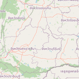
Map view of Sai Thong National Park

Use this park location map to pinpoint Sai Thong National Park in Thailand, understand its exact geographic position, and read its mapped placement within the surrounding landscape more clearly.

Pigeon | © OpenStreetMap contributors

Location context for Sai Thong National Park

Chaiyaphum Province
Park atlas

Browse surrounding protected landscapes and compare regional park geography around Sai Thong National Park.

Explore Other National Parks and Protected Areas Near Sai Thong National Park
After exploring Sai Thong National Park's mountain terrain and flower fields, compare its unique features with other protected areas across Thailand's northeastern highlands. Trace the regional spread of national parks and forest reserves, mapping their geographic distribution and conservation profiles to deepen your understanding of the country's diverse landscapes.
National parkChaiyaphum Province

Pa Hin Ngam National Park: Protected Area Atlas and Geographic Discovery in Chaiyaphum

Explore mapped boundaries and regional landscape context.

Pa Hin Ngam National Park is a significant national park entity located within Chaiyaphum Province, Thailand. This page offers detailed insight into its protected landscape, focusing on its mapped boundaries and how it fits into the regional geography of northeastern Thailand. Understand its identity as a conservation landscape through structured atlas exploration.

Area
100 km²
Established
1994
IUCN
II
Visitors
106.4K annual
National parkThailand

Tat Ton National Park: Thailand's National Park Geography and Mapped Landscape

Explore its protected boundaries and natural terrain.

Delve into the specifics of Tat Ton National Park, a protected natural area in Thailand. This page provides a detailed exploration of its mapped boundaries, regional geography, and the character of its natural terrain. Understand its value as a national park for understanding the distribution of protected landscapes and how they contribute to the overall geographic context of Thailand.

Area
217 km²
Established
1980
IUCN
II
Visitors
388.7K annual
National parkPhetchabun Province

Tat Mok National Park: A National Park within Phetchabun Province's Mapped Landscapes

Exploring its protected land and regional geographic context.

Tat Mok National Park is a designated national park offering rich opportunities for geographic discovery. Situated in Thailand's Phetchabun Province, this protected area contributes to the region's atlas of natural landscapes. Users can explore the mapped boundaries and understand the park's place within the broader geography of Phetchabun, highlighting its role as a conservation landscape within Thailand.

Area
290 km²
Established
1998
IUCN
II
Visitors
17.9K annual
National parkPhetchabun Province

Nam Nao National Park: Protected Landscape and Regional Geography

Explore maps and natural terrain of this Northern Thailand park.

Nam Nao National Park, situated in Phetchabun Province, Thailand, is a large national park distinguished by its rugged mountainous terrain and extensive pine forest landscapes. This protected area is vital for its role in conservation, housing significant biodiversity and forming a natural boundary between regions. Through its mapped geography and diverse natural settings, Nam Nao National Park offers a key destination for understanding protected land dynamics and regional natural landscapes.

Area
966 km²
Established
1972
IUCN
II
Visitors
31.8K annual
National parkPhetchabun Province

Khao Kho National Park: Protected Landscape Geography and Mapped Boundaries

Discover natural terrain within Phetchabun Province.

Gain insight into Khao Kho National Park, a key protected area situated in Phetchabun Province, Thailand. This entry focuses on its geographic significance, mapped park boundaries, and its place within the diverse landscapes of lower northern Thailand. Explore the atlas-ready details that define Khao Kho National Park as a distinct protected landscape, offering a clear view of its regional context and natural terrain.

Area
483 km²
Established
2012
IUCN
II
Visitors
33.6K annual
National parkThailand

Phu Pha Man National Park: Dramatic Cliffs, Caves, and Dinosaur Tracks in Thailand's Protected Landscape

Explore mapped geography and prehistoric fossil sites within Thailand's Phu Pha Man National Park.

Phu Pha Man National Park is a protected area in Thailand distinguished by its rugged limestone formations, significant cave networks, and dramatic waterfalls. Beyond its scenic beauty, the park is a globally important site for paleontology, holding Asia's oldest known dinosaur tracks. This page provides an atlas-style view of its protected landscape, local geography, and the unique prehistoric discoveries that define its identity.

Area
350 km²
Established
2000
IUCN
II
Visitors
9.7K annual
National parkLoei Province

Phu Kradueng National Park: Sandstone Mesa Protected Landscape and Geographic Atlas

Discover mapped boundaries and pine savanna terrain.

Phu Kradueng National Park, situated in Loei Province, Thailand, is a remarkable protected area defined by its large sandstone mesa and striking cliff-edged summit plateau. This page offers detailed geographic insights into the park's unique landscape, including its pine savanna ecosystems, diverse forest types transitioning from lower slopes to the summit, and its cool, refreshing climate. Explore Phu Kradueng National Park's mapped boundaries and natural terrain for a deeper understanding of this significant conservation landscape.

Area
348 km²
Established
1962
IUCN
II
Visitors
86.3K annual
National parkPhitsanulok Province

Thung Salaeng Luang National Park: A Protected National Park in Phitsanulok Province

Explore its mapped geography and natural landscape context.

Delve into Thung Salaeng Luang National Park, a designated national park situated in the Phitsanulok Province region of Thailand. This detail page focuses on its protected landscape features, mapped boundaries, and the surrounding geographic context, providing essential information for atlas-driven exploration and understanding of conservation areas. Understand the unique natural terrain and regional significance of this park entity.

Area
1,262 km²
Established
1963
IUCN
II
Visitors
52.1K annual

Common questions about visiting, size, designation, and location context for Sai Thong National Park

Sai Thong National Park FAQs for park facts, access, geography, and protected area context
Find quick answers about Sai Thong National Park, including protected-area facts, park geography, trail and visitor context, and how the park fits into its surrounding country and regional landscape.
MoriAtlas Explorer

Continue Your Protected Areas Search Across the Global Atlas

Deepen your exploration by continuing the structured search for national parks and protected areas worldwide. Utilize the comprehensive filtering capabilities to compare different conservation landscapes and refine your understanding of global park geography. Discover more about the distribution and characteristics of protected natural areas.

Global natural geography