

Mori Atlas logo
National parkTat Ton National Park

Discover the geographic boundaries and natural terrain of Tat Ton National Park.

Tat Ton National Park: Thailand's Mapped Protected Landscape and National Park Geography

Tat Ton National Park represents a distinct protected area within Thailand's diverse geography. As a key national park, its presence is vital for understanding the mapped distribution of conservation landscapes across the region. This detailed view explores the park's specific geographic identity, its natural terrain, and its place within the broader atlas of Thailand's protected lands, offering a clear lens for landscape exploration.

WaterfallsMountain ParksDipterocarp ForestsNortheastern ThailandNature ReservesForest Conservation

Tat Ton National Park

National park

Park overview

Structured park overview, official facts, and landscape profile for Tat Ton National Park

Tat Ton National Park park facts, protected area profile, and essential visitor context
Review the core facts for Tat Ton National Park, including designation, size, terrain, visitor scale, habitats, and operating context in one park-focused overview.

About Tat Ton National Park

Tat Ton National Park occupies a significant area of the Laen Kha mountain range in northeastern Thailand's Chaiyaphum Province. The park's establishment in 1980 reflected Thailand's growing commitment to protecting representative examples of the country's diverse ecosystems during that period of expanded national park development. The mountainous terrain, with its three named peaks of Phu Kaset, Phu Dee, and Phu Youk, creates topographical variety that supports distinct habitat zones within the park. The park's proximity to Chaiyaphum town, approximately 23 kilometers to the south, makes it a convenient destination for both local residents and travelers exploring the region. Beyond its natural attractions, the park functions as an important watershed area, with numerous streams feeding into the broader drainage systems of the region. The combination of accessible natural beauty, substantial forest cover, and historical protected status positions Tat Ton as a meaningful component of Thailand's conservation estate.

Quick facts and research context for Tat Ton National Park

Tat Ton National Park spans 217 square kilometers in Chaiyaphum Province, making it one of the larger protected areas in northeastern Thailand. The park was established in December 1980 and is managed by the Department of National Parks, Wildlife and Plant Conservation. Its elevation range and three mountain peaks create diverse microhabitats within the park boundaries. The park received approximately 389,000 visitors in 2019, indicating its popularity as a recreational and nature tourism destination within the region.

Park context

Deeper park guide and search-rich context for Tat Ton National Park

Tat Ton National Park history, landscape, wildlife, and travel context
Explore Tat Ton National Park through its history, landscape character, ecosystems, wildlife, conservation priorities, cultural context, and seasonal travel timing in a structured park guide built for atlas discovery and search intent.

Why Tat Ton National Park stands out

Tat Ton National Park is best known for its impressive waterfall system, with Tat Ton waterfall being the centerpiece attraction. This waterfall drops approximately 6 meters in height but expands dramatically to about 50 meters in width during the rainy season from May to October, creating a spectacular sheet of falling water. The park's highland scenery, with its three mountain peaks and forested ridgelines, provides a distinctive mountainous character uncommon among Thailand's eastern national parks. The combination of accessible waterfall views and elevated forest landscapes makes Tat Ton particularly popular with visitors seeking day trips from Chaiyaphum and surrounding areas.

Tat Ton National Park history and protected-area timeline

Tat Ton National Park was officially designated on December 31, 1980, becoming Thailand's 23rd national park. This designation occurred during a period when Thailand was systematically expanding its network of protected areas to preserve representative samples of the country's ecological diversity. The selection of the Laen Kha mountain area for protection reflected recognition of the region's value as a watershed, its relatively intact forest cover at the time, and the presence of notable scenic features such as the waterfalls that would later become the park's primary visitor attractions. The park has been managed by the Department of National Parks, Wildlife and Plant Conservation since its establishment, with ongoing responsibilities for visitor management, resource protection, and habitat maintenance.

Tat Ton National Park landscape and geographic character

The landscape of Tat Ton National Park is defined by its mountainous character within the Laen Kha range. Three prominent peaks dominate the park's topography: Phu Kaset, Phu Dee, and Phu Youk, each rising above the surrounding slopes and contributing to the park's distinctive highland silhouette. The terrain features forested slopes, rocky outcrops, and numerous stream courses that descend from the higher elevations. The valley areas and stream corridors provide lower-elevation passages through the mountainous terrain, while the ridgelines offer elevated perspectives over the surrounding landscape. The park's 217 square kilometer extent encompasses both the steeper mountain slopes and the more gradual approaches to the higher peaks, creating a varied topographical experience for visitors exploring different areas.

Tat Ton National Park ecosystems, habitats, and plant life

The forests of Tat Ton National Park are classified as dipterocarp and dry evergreen formations, representing vegetation types characteristic of northeastern Thailand's elevated terrain. The dipterocarp forests contain species such as Shorea roxburghii, Shorea obtusa, Dipterocarpus tuberculatus, and Shorea siamensis, which are common components of Thailand's semi-evergreen and dry evergreen forest communities. The dry evergreen component includes species adapted to the more seasonal climate patterns of the region. Additional tree species documented in the park include Irvingia malayana, Calophyllum polyanthum, Xylia xylocarpa, Sindora siamensis, Garcinia celebica, Dalbergia oliveri, and Memecylon ovatum, along with the bamboo species Vietnamosasa pusilla. This forest composition supports the park's ecological functions and provides the habitat structure for its wildlife communities.

Tat Ton National Park wildlife and species highlights

The wildlife community in Tat Ton National Park includes several mammal species characteristic of Thailand's forest environments. Barking deer, also known as Muntjac, are present in the park's forested areas, representing a common small ungulate species in Thai protected areas. Wild pigs are documented within the park boundaries, functioning as omnivorous forest residents that contribute to ecosystem processes through their foraging activities. Smaller mammals include mongoose species and the Siamese hare, the latter being a native lagomorph adapted to the forest understory and edge habitats. While the Wikipedia source provides a relatively limited inventory of specific wildlife species, the forest habitats likely support additional bird, reptile, and invertebrate communities that contribute to the park's overall biodiversity.

Tat Ton National Park conservation status and protection priorities

Tat Ton National Park functions as a protected area within Thailand's national park system, receiving designation as an IUCN Category II protected area. The park's protected status provides legal framework for forest conservation, wildlife protection, and management of visitor use. As part of the Laen Kha mountain system, the park plays a role in watershed protection for downstream areas, helping to regulate water flow and maintain water quality in surrounding agricultural landscapes. The preservation of the dipterocarp and dry evergreen forests within the park boundaries contributes to maintaining forest cover in Chaiyaphum Province, where agricultural expansion has reduced natural forest area in surrounding regions.

Tat Ton National Park cultural meaning and human context

Tat Ton National Park does not have extensively documented cultural heritage features in the available source material. The park's name and the Thai designation "อุทยานแห่งชาติตาดโตน" reflect local toponymy associated with the area prior to its protected area designation. The park's location in Chaiyaphum Province places it within a region that has historical connections to the broader cultural landscape of northeastern Thailand, though specific indigenous or historical cultural features within the park boundaries are not well documented in the available sources.

Top sights and standout views in Tat Ton National Park

The primary highlight of Tat Ton National Park is the impressive Tat Ton waterfall, which transforms from a 6-meter vertical drop during the dry season into a 50-meter wide curtain of water during the rainy months. Additional waterfalls including Tat Fa, Pha Lang, and Pha Song Chan provide secondary waterfall attractions throughout the park. The three mountain peaks of Phu Kaset, Phu Dee, and Phu Youk offer elevated terrain for visitors interested in exploring the park's higher elevations. The combination of accessible waterfalls, forested mountain scenery, and proximity to Chaiyaphum makes Tat Ton a popular destination for day visitors and nature enthusiasts.

Best time to visit Tat Ton National Park

The optimal time to visit Tat Ton National Park depends on the type of experience desired. The waterfall viewing is most spectacular during the rainy season from May to October, when water volume peaks and Tat Ton waterfall reaches its full width. However, the wet season also brings heavier vegetation growth and potential trail conditions that may affect access to some areas. The dry season months offer different advantages, with clearer weather and easier trail conditions, though waterfall flow is reduced. For general nature exploration, the transition periods between wet and dry seasons often provide favorable conditions with comfortable temperatures and manageable rainfall.

Park location guide

Geography guide, regional context, and park location map for Tat Ton National Park

Tat Ton National Park park geography, regions, and map view in Thailand
Understand where Tat Ton National Park sits in Thailand through a broader geographic reading of the surrounding landscape, nearby location context, and its mapped position within the national park landscape.

How Tat Ton National Park fits into Thailand

Thailand is a Southeast Asian nation formerly called Siam, located in mainland Southeast Asia. It operates as a unitary parliamentary constitutional monarchy under King Vajiralongkorn. The country borders Myanmar, Laos, Cambodia, and Malaysia, with maritime boundaries involving Vietnam, Indonesia, and India. Thailand has a population of nearly 66 million and covers approximately 513,120 km². Historically, the Sukhothai Kingdom marks the beginning of Thai history, followed by the powerful Ayutthaya Kingdom.

Wider geography shaping Tat Ton National Park in Thailand

Thailand occupies mainland Southeast Asia with borders to Myanmar (west/northwest), Laos (east/northeast), Cambodia (southeast), and Malaysia (south). The country has coastline along the Gulf of Thailand to the southeast and the Andaman Sea to the southwest. The territory covers approximately 513,120 km².

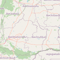
Map view of Tat Ton National Park

Use this park location map to pinpoint Tat Ton National Park in Thailand, understand its exact geographic position, and read its mapped placement within the surrounding landscape more clearly.

Pigeon | © OpenStreetMap contributors

Location context for Tat Ton National Park

Chaiyaphum Province
Park atlas

Trace connected landscapes, mountain ranges, and waterfall systems across the regional park geography

Discover Other National Parks and Protected Areas Near Tat Ton National Park in Northeastern Thailand
Browse a curated selection of national parks and protected areas adjacent to Tat Ton National Park, revealing the broader highland landscapes and diverse conservation zones of Northeastern Thailand. Compare unique waterfall systems, mountainous terrain, and forest reserves to deepen your understanding of the regional park geography and plan further explorations.
National parkChaiyaphum Province

Sai Thong National Park: Protected National Park in Chaiyaphum Province's Geography

Explore mapped landscape and protected area context.

Sai Thong National Park is a designated national park located in Chaiyaphum Province, Thailand, contributing to the region's extensive network of protected areas. Its protected landscape identity is shaped by the geography of northeastern Thailand, offering a unique focus for map-based discovery and understanding the distribution of natural areas. Explore the mapped terrain and regional context of this significant natural landmark.

Area
319 km²
Established
1992
IUCN
II
Visitors
51.2K annual
National parkChaiyaphum Province

Pa Hin Ngam National Park: Protected Area Atlas and Geographic Discovery in Chaiyaphum

Explore mapped boundaries and regional landscape context.

Pa Hin Ngam National Park is a significant national park entity located within Chaiyaphum Province, Thailand. This page offers detailed insight into its protected landscape, focusing on its mapped boundaries and how it fits into the regional geography of northeastern Thailand. Understand its identity as a conservation landscape through structured atlas exploration.

Area
100 km²
Established
1994
IUCN
II
Visitors
106.4K annual
National parkKhon Kaen Province

Phu Wiang National Park: Detailed Protected Landscape and Regional Geographic Context

Explore mapped park boundaries and natural terrain in Khon Kaen Province.

Phu Wiang National Park serves as a vital component of Thailand's protected areas network, situated within the geographic landscape of Khon Kaen Province. This entry facilitates a detailed atlas-style examination of the park's identity as a national park, focusing on its geographic footprint and the surrounding regional context. Users can trace the protected landscape's features and understand its place within the broader mapped terrain of northeastern Thailand.

Area
325 km²
Established
1965
IUCN
II
Visitors
6.2K annual
National parkThailand

Phu Pha Man National Park: Dramatic Cliffs, Caves, and Dinosaur Tracks in Thailand's Protected Landscape

Explore mapped geography and prehistoric fossil sites within Thailand's Phu Pha Man National Park.

Phu Pha Man National Park is a protected area in Thailand distinguished by its rugged limestone formations, significant cave networks, and dramatic waterfalls. Beyond its scenic beauty, the park is a globally important site for paleontology, holding Asia's oldest known dinosaur tracks. This page provides an atlas-style view of its protected landscape, local geography, and the unique prehistoric discoveries that define its identity.

Area
350 km²
Established
2000
IUCN
II
Visitors
9.7K annual
National parkPhetchabun Province

Tat Mok National Park: A National Park within Phetchabun Province's Mapped Landscapes

Exploring its protected land and regional geographic context.

Tat Mok National Park is a designated national park offering rich opportunities for geographic discovery. Situated in Thailand's Phetchabun Province, this protected area contributes to the region's atlas of natural landscapes. Users can explore the mapped boundaries and understand the park's place within the broader geography of Phetchabun, highlighting its role as a conservation landscape within Thailand.

Area
290 km²
Established
1998
IUCN
II
Visitors
17.9K annual
Green fields, trees, and pink-hued mountains in a watercolor landscape
National parkKhon Kaen Province

Nam Phong National Park: Mapped Protected Landscape and Geography in Khon Kaen Province

Explore scenic viewpoints, rock formations, and reservoir landscapes.

Nam Phong National Park presents a compelling case study in protected landscape geography, particularly within Thailand's northeastern region. This national park is defined by its mountainous terrain, featuring the Phu Phan Kham and Phu Meng ranges that dramatically meet the waters of the Ubol Ratana Dam reservoir. Its mapped boundaries encompass striking viewpoints like Hin Chang Si, prehistoric rock paintings, and geological formations, offering a detailed look at its natural and archaeological significance for atlas exploration.

Area
197 km²
Established
2000
IUCN
II
Visitors
68.3K annual
National parkPhetchabun Province

Nam Nao National Park: Protected Landscape and Regional Geography

Explore maps and natural terrain of this Northern Thailand park.

Nam Nao National Park, situated in Phetchabun Province, Thailand, is a large national park distinguished by its rugged mountainous terrain and extensive pine forest landscapes. This protected area is vital for its role in conservation, housing significant biodiversity and forming a natural boundary between regions. Through its mapped geography and diverse natural settings, Nam Nao National Park offers a key destination for understanding protected land dynamics and regional natural landscapes.

Area
966 km²
Established
1972
IUCN
II
Visitors
31.8K annual
National parkLoei Province

Phu Kradueng National Park: Sandstone Mesa Protected Landscape and Geographic Atlas

Discover mapped boundaries and pine savanna terrain.

Phu Kradueng National Park, situated in Loei Province, Thailand, is a remarkable protected area defined by its large sandstone mesa and striking cliff-edged summit plateau. This page offers detailed geographic insights into the park's unique landscape, including its pine savanna ecosystems, diverse forest types transitioning from lower slopes to the summit, and its cool, refreshing climate. Explore Phu Kradueng National Park's mapped boundaries and natural terrain for a deeper understanding of this significant conservation landscape.

Area
348 km²
Established
1962
IUCN
II
Visitors
86.3K annual

Common questions about visiting, size, designation, and location context for Tat Ton National Park

Tat Ton National Park FAQs for park facts, access, geography, and protected area context
Find quick answers about Tat Ton National Park, including protected-area facts, park geography, trail and visitor context, and how the park fits into its surrounding country and regional landscape.
MoriAtlas Explorer

Continue Your Protected Areas Search Across the Global Atlas

Deepen your exploration by continuing the structured search for national parks and protected areas worldwide. Utilize the comprehensive filtering capabilities to compare different conservation landscapes and refine your understanding of global park geography. Discover more about the distribution and characteristics of protected natural areas.

Global natural geography