

Mori Atlas logo
National parkTat Mok National Park

Mapping the protected boundaries and natural terrain of this national park.

Tat Mok National Park: Protected Landscape and Geography in Phetchabun Province, Thailand

Tat Mok National Park represents a significant protected area situated within the geographically diverse Phetchabun Province of Thailand. As a national park, its mapped boundaries delineate a distinct natural landscape valuable for atlas-based exploration. Understanding Tat Mok National Park involves appreciating its regional geographic setting and the specific natural terrain it encompasses, contributing to a broader understanding of protected lands in Southeast Asia.

National ParkWaterfallForest ReserveMountain LandscapeBirdwatchingWildlife Habitat

Tat Mok National Park

National park

Park overview

Structured park overview, official facts, and landscape profile for Tat Mok National Park

Tat Mok National Park park facts, protected area profile, and essential visitor context
Review the core facts for Tat Mok National Park, including designation, size, terrain, visitor scale, habitats, and operating context in one park-focused overview.

About Tat Mok National Park

Tat Mok National Park occupies a mountainous landscape in Phetchabun Province, approximately 37 kilometers east of the provincial capital. The terrain is dominated by Tat Mok Mountain, from which the park derives its name. The protected area forms part of a contiguous block of protected lands that includes Phu Pha Daeng Wildlife Sanctuary to the east, Nam Nao National Park to the north, Phu Khiao Wildlife Sanctuary to the east, and Tabo-Huai Yai Wildlife Sanctuary to the south. This network of protected areas creates an ecological corridor through the forested highlands of central Thailand. The park's hydrological significance extends beyond its boundaries, as its streams and waterfalls feed the Pa Sak River and Chi River, two major river systems that support communities and agriculture downstream. The combination of waterfall scenery, forested slopes, and watershed protection defines the park's identity as both a recreational destination and an ecological preserve.

Quick facts and research context for Tat Mok National Park

Tat Mok National Park spans roughly 290 square kilometers in Phetchabun Province, northeastern Thailand. Established in 1998, it is the 87th national park in Thailand and is managed by the Department of National Parks, Wildlife and Plant Conservation through regional office 11 in Phitsanulok. The park features a single-level waterfall known as Tat Mok waterfall, standing approximately 200 to 300 meters high, as well as a multi-tiered waterfall called Song Nang with 12 distinct levels. The park's forest ecosystems include mixed deciduous, deciduous dipterocarp, dry evergreen, and hill evergreen forest types, supporting a diversity of wildlife including Asian elephants, gaurs, and over 170 bird species.

Park context

Deeper park guide and search-rich context for Tat Mok National Park

Tat Mok National Park history, landscape, wildlife, and travel context
Explore Tat Mok National Park through its history, landscape character, ecosystems, wildlife, conservation priorities, cultural context, and seasonal travel timing in a structured park guide built for atlas discovery and search intent.

Why Tat Mok National Park stands out

Tat Mok National Park is best known for its dramatic Tat Mok waterfall, a single-tiered cascade plunging approximately 200 to 300 meters down the mountainside, and the adjacent Song Nang waterfall with its twelve tiers. The park's forested mountain landscape and its role as a critical watershed area for the Pa Sak and Chi River systems make it regionally significant. The diversity of forest types, from deciduous dipterocarp to hill evergreen forest, supports a rich community of wildlife including large mammals such as Asian elephant and gaur, as well as a notable bird population exceeding 170 species.

Tat Mok National Park history and protected-area timeline

The establishment of Tat Mok National Park followed a gradual process of recognition and survey. In mid-1991, a forest survey was conducted in the area, during which a beautiful waterfall was discovered and deemed suitable for development as a tourist attraction. This initial survey highlighted the natural value of the landscape. Subsequently, in 1995, the Royal Forest Department sought additional information regarding the Tabo forest and Huai Yai forest areas with the intention of establishing a national park. These efforts culminated in the formal declaration of Tat Mok as Thailand's 87th national park on 30 October 1998. Since 2002, the park has been administered by Protected Areas Regional Office 11, based in Phitsanulok, which oversees management of multiple protected areas in the region.

Tat Mok National Park landscape and geographic character

The landscape of Tat Mok National Park is characterized by mountainous terrain with steep slopes and forested ridges. Tat Mok Mountain forms the central topographic feature, rising dramatically from the surrounding landscape. The park's drainage system features several streams that descend through the forest, feeding the prominent waterfalls that are central to the park's identity. The most striking of these is the single-tiered Tat Mok waterfall, with a vertical drop of approximately 200 to 300 meters. Nearby, the Song Nang waterfall descends in twelve distinct tiers, creating a cascade of smaller drops through the forest. The combination of high ridgelines, flowing water, and dense forest cover creates a scenic landscape typical of the Phetchabun highland region.

Tat Mok National Park ecosystems, habitats, and plant life

Tat Mok National Park supports a complex mosaic of forest types reflecting the site's ecological diversity. The park contains mixed deciduous forest, deciduous dipterocarp forest, dry evergreen forest, and hill evergreen forest. This diversity of forest types results from variations in elevation, aspect, and local climate conditions within the protected area. The deciduous dipterocarp forests are characteristic of the seasonal tropics of mainland Southeast Asia, with trees shedding leaves during the dry season. The hill evergreen forests occupy higher elevations and more sheltered locations, maintaining more continuous foliage throughout the year. These forest habitats collectively support the park's wildlife community and maintain watershed function. Important tree species recorded in the park include Dipterocarpus alatus, Hopea odorata, Lagerstroemia calyculata, Pterocarpus macrocarpus, Tectona grandis, and Xylia xylocarpa.

Tat Mok National Park wildlife and species highlights

The wildlife community of Tat Mok National Park includes several notable mammal species. Large mammals present in the park include Asian elephant, gaur, and sambar deer. Primates are represented by the Assam macaque and the nocturnal Bengal slow loris. The park also supports smaller mammals such as the grey-bellied squirrel, Malayan porcupine, northern treeshrew, wild boar, and golden jackal. The bird fauna is particularly diverse, with approximately 170 species recorded, including around 110 species of passerine birds from 33 families. Notable bird species include the great hornbill, silver pheasant, common hill myna, and various thrushes, babblers, and flycatchers. Reptiles found in the park include the big-headed turtle, forest garden lizard, Oriental whip snake, Tokay gecko, and white-lipped pit viper.

Tat Mok National Park conservation status and protection priorities

Tat Mok National Park contributes to Thailand's protected area network by preserving a block of forest habitat that connects with multiple adjacent wildlife sanctuaries. This connectivity is ecologically significant, as it allows for wildlife movement between protected areas and maintains larger-scale ecological processes. The park's role as a watershed area for the Pa Sak and Chi River systems extends its conservation importance beyond its boundaries, as the forests help regulate water flow and maintain water quality for downstream users. The diversity of forest types represented within the park, from lowland deciduous dipterocarp to hill evergreen forest, ensures representation of multiple ecological communities within the protected area system.

Tat Mok National Park cultural meaning and human context

Tat Mok National Park exists within the cultural landscape of Phetchabun Province, an area with historical significance in Thai history. The park's name derives from local geography, specifically Tat Mok Mountain, and the Thai-language designation อุทยานแห่งชาติตาดหมอก translates to Tat Mok National Park. The discovery of the waterfall during a 1991 survey and its subsequent evaluation for tourism potential reflects the ongoing relationship between local communities and the natural environment. The park's proximity to Phetchabun city and its inclusion in the regional network of protected areas managed from Phitsanulok connects it to broader administrative systems for natural resource management in central-northern Thailand.

Top sights and standout views in Tat Mok National Park

Tat Mok National Park offers visitors the opportunity to experience the dramatic scenery of a forest-covered mountain landscape in central Thailand. The park's two waterfalls, the towering single-tier Tat Mok waterfall and the twelve-tiered Song Nang waterfall, represent the primary scenic attractions. The diverse forest environments, ranging from deciduous dipterocarp to hill evergreen forest, support wildlife viewing opportunities including large mammals and over 170 bird species. The park's position within a larger network of connected protected areas, bordering multiple wildlife sanctuaries and linking to Nam Nao National Park, underscores its regional ecological importance. The watershed function providing water to the Pa Sak and Chi rivers adds environmental significance to the recreational and scenic values.

Best time to visit Tat Mok National Park

The optimal time to visit Tat Mok National Park corresponds to the cooler, drier months typical of the Thai winter season, roughly from November through February. During this period, reduced rainfall makes waterfall flow more predictable and trail conditions more favorable for hiking and exploration. The dry season, from approximately November through April, offers generally clear skies and comfortable temperatures for outdoor activities. However, visitors should be aware that the forest environment retains its appeal throughout the year, and the monsoon season from May through October brings lush vegetation and fuller waterfall flows, though trail conditions may be more challenging. The park's moderate elevation and forested terrain provide a cooler environment than the lowland plains, making it a potential escape from the heat during the hotter months.
Park location guide

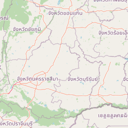
Geography guide, regional context, and park location map for Tat Mok National Park

Tat Mok National Park park geography, regions, and map view in Thailand
Understand where Tat Mok National Park sits in Thailand through a broader geographic reading of the surrounding landscape, nearby location context, and its mapped position within the national park landscape.

How Tat Mok National Park fits into Thailand

Thailand is a Southeast Asian nation formerly called Siam, located in mainland Southeast Asia. It operates as a unitary parliamentary constitutional monarchy under King Vajiralongkorn. The country borders Myanmar, Laos, Cambodia, and Malaysia, with maritime boundaries involving Vietnam, Indonesia, and India. Thailand has a population of nearly 66 million and covers approximately 513,120 km². Historically, the Sukhothai Kingdom marks the beginning of Thai history, followed by the powerful Ayutthaya Kingdom.

Wider geography shaping Tat Mok National Park in Thailand

Thailand occupies mainland Southeast Asia with borders to Myanmar (west/northwest), Laos (east/northeast), Cambodia (southeast), and Malaysia (south). The country has coastline along the Gulf of Thailand to the southeast and the Andaman Sea to the southwest. The territory covers approximately 513,120 km².

Map view of Tat Mok National Park

Use this park location map to pinpoint Tat Mok National Park in Thailand, understand its exact geographic position, and read its mapped placement within the surrounding landscape more clearly.

Pigeon | © OpenStreetMap contributors

Location context for Tat Mok National Park

Phetchabun Province
Park atlas

Trace connected protected landscapes and regional park geography adjacent to Tat Mok National Park, comparing their features.

Discover Other National Parks and Protected Areas Near Tat Mok National Park
Explore a curated list of national parks and protected areas geographically close to Tat Mok National Park, showcasing diverse forest reserves and mountain landscapes across central Thailand. This expanded geographic perspective helps compare watershed significance, varied ecosystems, and connected conservation efforts within the surrounding Phetchabun highland region.
National parkPhetchabun Province

Nam Nao National Park: Protected Landscape and Regional Geography

Explore maps and natural terrain of this Northern Thailand park.

Nam Nao National Park, situated in Phetchabun Province, Thailand, is a large national park distinguished by its rugged mountainous terrain and extensive pine forest landscapes. This protected area is vital for its role in conservation, housing significant biodiversity and forming a natural boundary between regions. Through its mapped geography and diverse natural settings, Nam Nao National Park offers a key destination for understanding protected land dynamics and regional natural landscapes.

Area
966 km²
Established
1972
IUCN
II
Visitors
31.8K annual
National parkPhetchabun Province

Khao Kho National Park: Protected Landscape Geography and Mapped Boundaries

Discover natural terrain within Phetchabun Province.

Gain insight into Khao Kho National Park, a key protected area situated in Phetchabun Province, Thailand. This entry focuses on its geographic significance, mapped park boundaries, and its place within the diverse landscapes of lower northern Thailand. Explore the atlas-ready details that define Khao Kho National Park as a distinct protected landscape, offering a clear view of its regional context and natural terrain.

Area
483 km²
Established
2012
IUCN
II
Visitors
33.6K annual
National parkLoei Province

Phu Kradueng National Park: Sandstone Mesa Protected Landscape and Geographic Atlas

Discover mapped boundaries and pine savanna terrain.

Phu Kradueng National Park, situated in Loei Province, Thailand, is a remarkable protected area defined by its large sandstone mesa and striking cliff-edged summit plateau. This page offers detailed geographic insights into the park's unique landscape, including its pine savanna ecosystems, diverse forest types transitioning from lower slopes to the summit, and its cool, refreshing climate. Explore Phu Kradueng National Park's mapped boundaries and natural terrain for a deeper understanding of this significant conservation landscape.

Area
348 km²
Established
1962
IUCN
II
Visitors
86.3K annual
National parkChaiyaphum Province

Sai Thong National Park: Protected National Park in Chaiyaphum Province's Geography

Explore mapped landscape and protected area context.

Sai Thong National Park is a designated national park located in Chaiyaphum Province, Thailand, contributing to the region's extensive network of protected areas. Its protected landscape identity is shaped by the geography of northeastern Thailand, offering a unique focus for map-based discovery and understanding the distribution of natural areas. Explore the mapped terrain and regional context of this significant natural landmark.

Area
319 km²
Established
1992
IUCN
II
Visitors
51.2K annual
National parkThailand

Phu Hin Rong Kla National Park: A Protected Mountain Landscape in Northern Thailand

Explore rock formations, waterfalls, and unique historical terrain.

Phu Hin Rong Kla National Park, situated in northern Thailand, is a significant national park known for its dramatic mountainous terrain, including impressive fractured rock formations and numerous multi-tiered waterfalls. This protected area also holds historical importance, having served as a former communist insurgent stronghold. Its rugged landscape is defined by steep ridges, deep valleys, and diverse forest ecosystems, making it a compelling destination for understanding Thailand's natural and historical geography within a mapped context.

Area
307 km²
Established
1984
IUCN
II
Visitors
289.2K annual
National parkPhitsanulok Province

Thung Salaeng Luang National Park: A Protected National Park in Phitsanulok Province

Explore its mapped geography and natural landscape context.

Delve into Thung Salaeng Luang National Park, a designated national park situated in the Phitsanulok Province region of Thailand. This detail page focuses on its protected landscape features, mapped boundaries, and the surrounding geographic context, providing essential information for atlas-driven exploration and understanding of conservation areas. Understand the unique natural terrain and regional significance of this park entity.

Area
1,262 km²
Established
1963
IUCN
II
Visitors
52.1K annual
National parkThailand

Phu Pha Man National Park: Dramatic Cliffs, Caves, and Dinosaur Tracks in Thailand's Protected Landscape

Explore mapped geography and prehistoric fossil sites within Thailand's Phu Pha Man National Park.

Phu Pha Man National Park is a protected area in Thailand distinguished by its rugged limestone formations, significant cave networks, and dramatic waterfalls. Beyond its scenic beauty, the park is a globally important site for paleontology, holding Asia's oldest known dinosaur tracks. This page provides an atlas-style view of its protected landscape, local geography, and the unique prehistoric discoveries that define its identity.

Area
350 km²
Established
2000
IUCN
II
Visitors
9.7K annual
National parkThailand

Tat Ton National Park: Thailand's National Park Geography and Mapped Landscape

Explore its protected boundaries and natural terrain.

Delve into the specifics of Tat Ton National Park, a protected natural area in Thailand. This page provides a detailed exploration of its mapped boundaries, regional geography, and the character of its natural terrain. Understand its value as a national park for understanding the distribution of protected landscapes and how they contribute to the overall geographic context of Thailand.

Area
217 km²
Established
1980
IUCN
II
Visitors
388.7K annual

Common questions about visiting, size, designation, and location context for Tat Mok National Park

Tat Mok National Park FAQs for park facts, access, geography, and protected area context
Find quick answers about Tat Mok National Park, including protected-area facts, park geography, trail and visitor context, and how the park fits into its surrounding country and regional landscape.
MoriAtlas Explorer

Continue Your Protected Areas Search Across the Global Atlas

Deepen your exploration by continuing the structured search for national parks and protected areas worldwide. Utilize the comprehensive filtering capabilities to compare different conservation landscapes and refine your understanding of global park geography. Discover more about the distribution and characteristics of protected natural areas.

Global natural geography