

Mori Atlas logo
National parkPhu Sa Dok Bua National Park

Discover the mapped geography and protected area boundaries of this national park in Amnat Charoen Province.

Phu Sa Dok Bua National Park: Protected Landscape and National Park Atlas Entry

Phu Sa Dok Bua National Park represents a key protected landscape within Amnat Charoen Province, Thailand. This entry serves as an atlas-style exploration point, detailing the park's mapped boundaries and its contribution to the regional geography. Understand the protected area's place within Thailand's network of natural landscapes and conservation efforts.

National ParkForestMountainLotusRock FormationsCave

Phu Sa Dok Bua National Park

National park

Park overview

Structured park overview, official facts, and landscape profile for Phu Sa Dok Bua National Park

Phu Sa Dok Bua National Park park facts, protected area profile, and essential visitor context
Review the core facts for Phu Sa Dok Bua National Park, including designation, size, terrain, visitor scale, habitats, and operating context in one park-focused overview.

About Phu Sa Dok Bua National Park

Phu Sa Dok Bua National Park protects a distinctive landscape in Thailand's northeastern region, where dry dipterocarp forest dominates the terrain beneath scattered hills and rocky outcrops. The park's establishment in 1992 formalized protection for an area that had long been known to local communities for its unusual natural features. The central attraction remains the mountain peak with its line of stone pools, each harboring lotus plants that seem to thrive in these unlikely circumstances. Beyond the lotus pools, the park contains impressive rock terraces that create dramatic visual textures across the landscape. Phu Pha Hom, rising to 386 meters, offers sweeping vistas over the forested valleys and the surrounding countryside of Yasothon, Mukdahan, and Amnat Charoen provinces. The park's relative remoteness from major tourism centers has helped preserve its character as a destination for visitors seeking authentic natural experiences rather than developed recreational facilities.

Quick facts and research context for Phu Sa Dok Bua National Park

Phu Sa Dok Bua National Park occupies a tri-province area in Thailand's Isan region, with its headquarters located in Amphoe Don Tan, Mukdahan Province. The protected area spans 231 square kilometers of dwarf dry dipterocarp forest, a distinctive ecosystem adapted to the region's seasonal climate. The park's most celebrated feature is the summit of its main mountain, where eleven natural stone pools contain lotus plants that bloom throughout the year. At 386 meters elevation, Phu Pha Hom provides visitors with panoramic views across the park's forested terrain and rock terraces. The park received 1,812 visitors in 2019, reflecting its status as a relatively off-the-beaten-path destination within Thailand's national park system.

Park context

Deeper park guide and search-rich context for Phu Sa Dok Bua National Park

Phu Sa Dok Bua National Park history, landscape, wildlife, and travel context
Explore Phu Sa Dok Bua National Park through its history, landscape character, ecosystems, wildlife, conservation priorities, cultural context, and seasonal travel timing in a structured park guide built for atlas discovery and search intent.

Why Phu Sa Dok Bua National Park stands out

The park is most renowned for its extraordinary lotus pools atop a 423-meter mountain, where eleven shallow stone basins each support different species of colorful lotus flowers despite being positioned on exposed rocky terrain rather than typical wetland habitat. This natural phenomenon, unexplained by conventional botanical understanding, has given the park its name Phu Sa Dok Bua, meaning mountain of lotus pools. The dry dipterocarp forest that blankets most of the park is another defining characteristic, representing a ecosystem type that dominates much of northeastern Thailand's upland terrain. The historical cave system used by the Communist Party of Thailand during the 1960s adds a layer of political history that distinguishes this park from purely natural preserves.

Phu Sa Dok Bua National Park history and protected-area timeline

The area that now comprises Phu Sa Dok Bua National Park was designated as a protected national park in 1992, making it one of Thailand's later-established protected areas. Prior to formal protection, the region was known to local communities for its unique lotus pools and served as grazing land for surrounding villages. The historical significance of the park extends to the 1960s, when a large cave within the park's boundaries served as one of the strongholds for the Communist Party of Thailand during that period of political conflict. This cave, capable of accommodating hundreds of people, represents a chapter in Thai history when communist insurgents operated from remote forest locations. The park's name, Phu Sa Dok Bua, has been applied to the area for generations, with the literal translation mountain of lotus pools referring to the mysterious appearance of lotus flowers in the stone pools atop the mountain.

Phu Sa Dok Bua National Park landscape and geographic character

The terrain of Phu Sa Dok Bua National Park consists of rolling hills and mountainous ridges composed primarily of sandstone and laterite formations. The landscape is characterized by dwarf dry dipterocarp forest that creates a uniform green canopy across the lower elevations, punctuated by exposed rock terraces and scattered boulders. The park's signature feature is a prominent peak reaching 423 meters in elevation, where a series of eleven shallow stone pools have formed in natural depressions in the rock. These pools, each only a few meters wide, create an unusual sight in the landscape, particularly because they support thriving colonies of lotus plants despite the apparently inhospitable rocky setting. Phu Pha Hom, at 386 meters, provides a secondary viewpoint offering extensive views across the park's forested terrain and into the surrounding agricultural landscape of northeastern Thailand.

Phu Sa Dok Bua National Park ecosystems, habitats, and plant life

The park's vegetation is dominated by dry dipterocarp forest, an ecosystem adapted to the pronounced dry season that characterizes northeastern Thailand. This forest type features trees of relatively modest height compared to wetter tropical forests, with species adapted to periodic drought and fire. The forest floor supports a diverse understory of grasses, shrubs, and herbaceous plants that undergo seasonal changes in response to rainfall patterns. The lotus pools represent an unusual botanical phenomenon, with different lotus species apparently colonizing each of the eleven pools. These aquatic plants have adapted to the shallow, static water in the rock depressions, creating an unexpected display of цветущие растения in an upland rocky setting. The combination of forest and rocky pool habitats creates a mosaic of ecological conditions within the park's boundaries.

Phu Sa Dok Bua National Park wildlife and species highlights

While the Wikipedia source does not provide detailed wildlife documentation, the dry dipterocarp forest ecosystem of Phu Sa Dok Bua National Park would be expected to support a variety of bird species, small mammals, and reptiles adapted to northeastern Thailand's forest environments. The rocky terrain and cave systems within the park provide habitat for bats and other cave-dwelling species. The lotus pools likely attract water birds and insects during the flowering season. The forest harbors common Southeast Asian fauna including various species of squirrels, snakes, and insects that characterize this ecosystem type.

Phu Sa Dok Bua National Park conservation status and protection priorities

Phu Sa Dok Bua National Park represents protected status for an ecosystem type that has faced significant pressure across northeastern Thailand from agricultural expansion and human settlement. The dry dipterocarp forest, while resilient to natural fire cycles, has been degraded in many areas outside protected reserves. By encompassing significant tracts of this forest type along with unique geological features, the park ensures that the lotus pools and surrounding landscape remain protected from development pressures. The park's IUCN Category II designation reflects its primary function as a national park for conservation and public enjoyment, balancing protection of the natural environment with limited visitor access.

Phu Sa Dok Bua National Park cultural meaning and human context

The name Phu Sa Dok Bua carries cultural significance beyond its descriptive meaning, as it reflects a local legend that the lotus in the mountain pools appeared spontaneously without human intervention. This folk explanation for the presence of lotus in an unexpected setting has become embedded in the park's identity and provides a narrative element that distinguishes the site from purely geological wonders. The cave used by the Communist Party of Thailand during the 1960s adds a layer of more recent political history to the cultural context of the landscape, representing a time when this remote area played a role in Thailand's domestic political conflicts. The park sits within the Isan region, which has its own distinct cultural identity within Thailand characterized by Lao linguistic influences and agricultural traditions.

Top sights and standout views in Phu Sa Dok Bua National Park

The eleven lotus pools on the mountain summit represent the park's most distinctive feature, a natural phenomenon where lotus flowers thrive in rocky depressions rather than typical wetland environments. The dry dipterocarp forest covering the park provides a characteristic northeastern Thailand landscape that differs dramatically from the country's better-known coastal and mountain parks. Rock terraces and viewpoints, particularly from Phu Pha Hom at 386 meters, offer panoramic vistas across the forested terrain. The historical cave used by the Communist Party of Thailand adds historical depth to the visitor experience, connecting natural landscapes with recent political history.

Best time to visit Phu Sa Dok Bua National Park

The park can be visited throughout the year, though the cool dry season from November to February typically offers the most comfortable conditions for hiking and outdoor exploration. The lotus pools are said to contain blooming lotus throughout the year, though the most prolific flowering may occur during the cooler months. The dry season, while bringing brownish forest colors, provides easier access to trails and viewpoints. The wet season from May to September brings greener vegetation but may make some paths more difficult and could affect visibility from viewpoints.

Park location guide

Geography guide, regional context, and park location map for Phu Sa Dok Bua National Park

Phu Sa Dok Bua National Park park geography, regions, and map view in Thailand
Understand where Phu Sa Dok Bua National Park sits in Thailand through a broader geographic reading of the surrounding landscape, nearby location context, and its mapped position within the national park landscape.

How Phu Sa Dok Bua National Park fits into Thailand

Thailand is a Southeast Asian nation formerly called Siam, located in mainland Southeast Asia. It operates as a unitary parliamentary constitutional monarchy under King Vajiralongkorn. The country borders Myanmar, Laos, Cambodia, and Malaysia, with maritime boundaries involving Vietnam, Indonesia, and India. Thailand has a population of nearly 66 million and covers approximately 513,120 km². Historically, the Sukhothai Kingdom marks the beginning of Thai history, followed by the powerful Ayutthaya Kingdom.

Wider geography shaping Phu Sa Dok Bua National Park in Thailand

Thailand occupies mainland Southeast Asia with borders to Myanmar (west/northwest), Laos (east/northeast), Cambodia (southeast), and Malaysia (south). The country has coastline along the Gulf of Thailand to the southeast and the Andaman Sea to the southwest. The territory covers approximately 513,120 km².

Map view of Phu Sa Dok Bua National Park

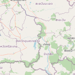
Use this park location map to pinpoint Phu Sa Dok Bua National Park in Thailand, understand its exact geographic position, and read its mapped placement within the surrounding landscape more clearly.

Pigeon | © OpenStreetMap contributors

Location context for Phu Sa Dok Bua National Park

Amnat Charoen ProvinceMukdahan ProvinceYasothon Province
Park atlas

Trace the Protected Landscapes and Regional Park Geography of Northeast Thailand

Explore Other National Parks and Protected Areas near Phu Sa Dok Bua National Park
Continue exploring national parks and protected areas in Northeast Thailand, comparing the dry dipterocarp forests, sandstone formations, and unique hydrological features found across the region. Understanding the geographic spread of these conservation landscapes provides valuable context for atlas-style park discovery, revealing regional patterns and diverse ecological zones beyond Phu Sa Dok Bua National Park.
National parkMukdahan Province

Phu Pha Thoep National Park: Mukdahan Province Protected National Park Geography

Explore its mapped protected landscape and regional context.

Phu Pha Thoep National Park is a designated national park in Thailand's Mukdahan Province, offering a distinct focus for geographic exploration. This resource provides detailed insights into its protected landscape, outlining mapped park boundaries and its integration within the regional geography. Understand the park's specific natural terrain and its value for structured atlas-style discovery, moving beyond simple location data to grasp its protected area significance.

Area
48 km²
IUCN
II
Visitors
47.6K annual
Relief
Upland
National parkSakon Nakhon Province

Phu Pha Yon National Park: Protected Landscape and Regional Geography in Sakon Nakhon Province

Explore the mapped boundaries and natural terrain of this Thai national park.

Phu Pha Yon National Park, situated in Sakon Nakhon Province, is a protected national park offering a focused point for geographic exploration. This park entity serves as a component of Thailand's broader protected area network, with its mapped boundaries and natural landscape providing essential context for regional geography studies. Understanding Phu Pha Yon National Park through its geographic setting and protected status enhances atlas-based discovery and appreciation of its place within the Khorat Plateau.

Area
829 km²
Established
1988
IUCN
II
Visitors
5K annual
National parkUbon Ratchathani Province

Pha Taem National Park: Mapped Protected Landscape in Ubon Ratchathani

National park exploration and geographic context

Pha Taem National Park serves as a distinct protected area within Ubon Ratchathani Province, offering a focused lens for geographic discovery. Understand its specific location, mapped boundaries, and the surrounding natural landscape context that defines this national park. This entry supports detailed atlas exploration of Thailand's protected territories.

Area
340 km²
Established
1991
IUCN
II
Visitors
180.2K annual
National parkUbon Ratchathani Province

Kaeng Tana National Park: Mapped Protected Landscape in Ubon Ratchathani Province

Explore Thailand's national park geography and boundaries.

Kaeng Tana National Park is a designated national park located in Ubon Ratchathani Province, Thailand. This atlas-focused content helps users understand its unique protected landscape identity and geographic setting. Explore the mapped context of Kaeng Tana National Park, contributing to a structured understanding of conservation areas and natural terrain within Thailand's broader geography.

Area
80 km²
Established
1981
IUCN
II
Visitors
31.2K annual
National parkSakon Nakhon Province

Phu Phan National Park: Thailand's Protected Mountain Landscape and Natural Atlas Entry

Explore dry dipterocarp forest and unique terrain in Sakon Nakhon.

Phu Phan National Park offers a detailed look into Thailand's northeastern geography, characterized by its mountainous terrain and extensive dry dipterocarp forests. As a national park, it represents a vital protected landscape within Sakon Nakhon Province, showcasing unique geological formations and providing a rich context for atlas-based exploration. Discover the park's mapped boundaries, its ecological significance, and the distinct natural features that define this prominent Isan region protected area.

Area
665 km²
Established
1972
IUCN
II
Visitors
4.9K annual
National parkSisaket Province

Khao Phra Wihan National Park: Protected Landscape and Archaeological Atlas Gateway

Explore dramatic red sandstone cliffs and historic Khmer ruins.

Khao Phra Wihan National Park in Sisaket Province, Thailand, is a protected landscape distinguished by its dramatic Pha Mo I Daeng red sandstone cliff and its role as a gateway to significant Khmer archaeological sites. This national park offers a deep dive into the region's unique geography, featuring rugged terrain, distinctive forest ecosystems, and prehistoric rock art. As a key entry point for understanding the Preah Vihear Temple's context, the park provides rich material for atlas-based exploration of border landscapes and historical terrain.

Area
130 km²
Established
1998
IUCN
II
Visitors
202.6K annual
Watercolor illustration of a river flowing through a valley with green forests and distant mountains
National parkVietnam

Phong Nha, Kẻ Bàng National Park: Vietnam's Karst Terrain and Subterranean World

Explore protected landscapes, cave systems, and geological wonders.

Phong Nha, Kẻ Bàng National Park in Vietnam is a globally significant protected landscape, recognized by UNESCO for its exceptional karst topography and extensive cave networks. This national park features dramatic limestone mountains, deep river gorges, and some of the world's most impressive subterranean formations, offering a rich atlas of natural history and geological wonders to explore.

Area
857.54 km²
Established
2001
IUCN
II
Visitors
740K annual
Green fields, trees, and pink-hued mountains in a watercolor landscape
National parkKhon Kaen Province

Nam Phong National Park: Mapped Protected Landscape and Geography in Khon Kaen Province

Explore scenic viewpoints, rock formations, and reservoir landscapes.

Nam Phong National Park presents a compelling case study in protected landscape geography, particularly within Thailand's northeastern region. This national park is defined by its mountainous terrain, featuring the Phu Phan Kham and Phu Meng ranges that dramatically meet the waters of the Ubol Ratana Dam reservoir. Its mapped boundaries encompass striking viewpoints like Hin Chang Si, prehistoric rock paintings, and geological formations, offering a detailed look at its natural and archaeological significance for atlas exploration.

Area
197 km²
Established
2000
IUCN
II
Visitors
68.3K annual

Common questions about visiting, size, designation, and location context for Phu Sa Dok Bua National Park

Phu Sa Dok Bua National Park FAQs for park facts, access, geography, and protected area context
Find quick answers about Phu Sa Dok Bua National Park, including protected-area facts, park geography, trail and visitor context, and how the park fits into its surrounding country and regional landscape.
MoriAtlas Explorer

Continue Your Protected Areas Search Across the Global Atlas

Deepen your exploration by continuing the structured search for national parks and protected areas worldwide. Utilize the comprehensive filtering capabilities to compare different conservation landscapes and refine your understanding of global park geography. Discover more about the distribution and characteristics of protected natural areas.

Global natural geography