

Mori Atlas logo
National parkPha Taem National Park

Discover mapped park boundaries and natural terrain within this key Thai national park.

Pha Taem National Park: Protected Landscape and Geographic Context in Ubon Ratchathani

Pha Taem National Park represents a significant protected area within Ubon Ratchathani Province, Thailand. This national park offers a focused point for atlas-driven discovery, allowing users to explore its defined boundaries and understand its place within the regional geography. Delve into the mapped landscape and protected land context of Pha Taem National Park to enrich your understanding of Thailand's natural areas.

Rock Art SitesMekong RiverDipterocarp ForestPrehistoric ArchaeologyGeological FormationsBorder Parks

Pha Taem National Park

National park

Park overview

Structured park overview, official facts, and landscape profile for Pha Taem National Park

Pha Taem National Park park facts, protected area profile, and essential visitor context
Review the core facts for Pha Taem National Park, including designation, size, terrain, visitor scale, habitats, and operating context in one park-focused overview.

About Pha Taem National Park

Pha Taem National Park occupies a strategic position along the lower Mekong River in Thailand's northeast, where the river forms a natural boundary between Thai and Laotian territory. The park's terrain is characterized by a series of steep sandstone cliffs that line the western bank of the Mekong, rising dramatically from the water's edge to create a landscape of considerable visual impact. Behind these cliff formations, the terrain transitions into rolling hills covered in Dipterocarp forest, the dominant vegetation type across much of the park. The name Pha Taem derives from the local dialect, where Taem refers to drawing, painting, or any action involving color to create images, a direct reference to the prehistoric pictographs that are the park's most celebrated feature. The archaeological significance of these rock paintings was first formally recognized following research by professors and students from Silpakorn University's Department of Archaeology, whose work in the early 1980s documented the extent and age of the artwork. This research led to the formal proposal that the area be protected as a national park, culminating in its designation in 1991. Beyond its archaeological treasures, the park offers visitors a hiking trail along the cliffside that provides panoramic views across the Mekong to the Laotian landscape beyond, a particularly popular route for witnessing sunrise. The combination of cultural, geological, and ecological values makes Pha Taem a unique destination within Thailand's national park system, one that attracts both those interested in prehistoric heritage and visitors seeking to experience the dramatic scenery of the Mekong corridor.

Quick facts and research context for Pha Taem National Park

Pha Taem National Park covers 340 square kilometres along the Mekong River in Ubon Ratchathani Province, northeastern Thailand. It was established as Thailand's 74th national park in 1991 and shares its eastern boundary with Laos, giving it the longest national park border in the country. The park features Dipterocarp forest dominated by Shorea obtusa, Shorea siamensis, and Dipterocarpus obtusifollus species, with dry evergreen forests occurring near watercourses. The prehistoric rock art site contains more than 300 images spanning approximately 180 meters of cliff face. Visitors in 2019 numbered approximately 180,155. The park is managed by Thailand's Department of National Park, Wildlife and Plant Conservation.

Park context

Deeper park guide and search-rich context for Pha Taem National Park

Pha Taem National Park history, landscape, wildlife, and travel context
Explore Pha Taem National Park through its history, landscape character, ecosystems, wildlife, conservation priorities, cultural context, and seasonal travel timing in a structured park guide built for atlas discovery and search intent.

Why Pha Taem National Park stands out

Pha Taem National Park is renowned for two exceptional features that distinguish it within Thailand's protected area system. First, the park preserves one of the most extensive and significant prehistoric rock art sites in mainland Southeast Asia, with pictographs dating back 3,000 to 4,000 years depicting human figures, handprints, and animals including the sacred giant Mekong catfish. Second, the park contains remarkable geological formations including mushroom-shaped rock pillars formed through differential erosion, and dramatic sandstone cliffs that receive the first sunlight to touch Thailand on each New Year's Day. The combination of ancient archaeological significance, distinctive geological landscapes, and the dramatic setting overlooking the Mekong River and Laos creates a destination that bridges cultural heritage, natural history, and scenic beauty.

Pha Taem National Park history and protected-area timeline

The historical trajectory of Pha Taem National Park reflects a transition from local superstition to recognized archaeological significance and finally to national protection. In earlier times, the area was regarded with fear by local peasants, who believed the mountain was protected by supernatural forces and referred to it as the "Mountain of Death," with folk beliefs holding that trespassers risked illness or even death. This perception limited access to the region for centuries. The transformation began with academic research when professors and students from Silpakorn University's Department of Archaeology conducted field investigations at Pha Taem, documenting prehistoric paintings in the Ban Kum and Huai Phai sub-district areas of Khong Chiam district. Their findings revealed artwork dating from 3,000 to 4,000 years ago, grouped into four main collections containing over 300 images, with the longest continuous sequence extending 180 meters. Following this research, the university department drafted a memorandum in May 1981 requesting that the Royal Forest Department designate the forest and mountain area as a national park. After nearly a decade of process, Pha Taem was officially declared Thailand's 74th national park on 31 December 1991, with an initial area of 212,500 rai approximately 340 square kilometres. The park encompasses portions of Khong Chiam District and parts of Si Mueang Mai and Pho Sai Districts within Ubon Ratchathani Province.

Pha Taem National Park landscape and geographic character

The landscape of Pha Taem National Park presents a distinctive combination of riverine, cliff, and forest environments that define its character. The most prominent feature is the line of sandstone cliffs that run parallel to the Mekong River, rising vertically from the water's edge to create dramatic precipices. These cliff faces serve as the canvas for the prehistoric rock art that makes the park famous. Among the most visually striking geological formations are the mushroom rocks, pillar-like structures with expanded caps created by differential erosion that has worn away softer rock beneath while leaving harder material projecting above. The terrain behind the cliffs consists of rolling hills covered predominantly by Dipterocarp forest, interspersed with dry evergreen forest in areas near streams and watercourses. The Mekong River itself forms the eastern boundary of the park, providing a navigational corridor and visual axis that frames views across to the Laotian landscape. The elevation changes from the river valley up to the forested ridges create a varied topography that supports different habitat types and contributes to the park's ecological diversity.

Pha Taem National Park ecosystems, habitats, and plant life

The ecological character of Pha Taem National Park is defined by its Dipterocarp forest ecosystem, a vegetation type typical of mainland Southeast Asia but represented here in a protected setting of regional significance. The forest is dominated by three key species: Shorea obtusa, Shorea siamensis, and Dipterocarpus obtusifollus, which form the structural and compositional backbone of the woodland. These trees create a canopy that supports a distinctive understory adapted to seasonal moisture variations. In areas adjacent to watercourses, the vegetation transitions to dry evergreen forest, reflecting the higher moisture availability in these riparian zones. The forest ecosystem provides habitat for a range of wildlife species and contributes to watershed protection along the Mekong corridor. The park's position along a major international river system also connects it to broader ecological processes, including the seasonal movements of larger mammals that cross between Thailand and Laos.

Pha Taem National Park wildlife and species highlights

Pha Taem National Park supports a modest but notable assemblage of wildlife species within its forest and cliff habitats. The mammal community includes several species adapted to the Dipterocarp forest environment: Siamese hares, barking deer, civets, and wild pigs are recorded as present within the park. The serow, a goat-antelope species, migrates from Laos into the park during the summer months, demonstrating the park's ecological connectivity with the broader Mekong region. Of particular significance is the seasonal migration of wild elephants, which move into areas of Ubon Ratchathani Province from Laos during February and March in search of food, particularly banana leaves and fruit. These elephants represent a notable wildlife attraction and underscore the park's role in maintaining wildlife corridors across the international boundary. In 2005, researchers discovered specimens of a new frog species, Fejervarya triora, within the park, adding to its biodiversity significance. The rock art depicting the giant Mekong catfish also reflects the presence of this large fish species in the Mekong River, a creature considered sacred in local cultural traditions.

Pha Taem National Park conservation status and protection priorities

Pha Taem National Park represents a protected area that combines multiple conservation values: archaeological heritage, geological features, and ecological habitats. The protection of the prehistoric rock art presents particular challenges, as the pigment and sandstone surfaces are vulnerable to both natural weathering and human impact. Ongoing conservation efforts focus on monitoring these artworks and implementing measures to prevent damage from visitors and environmental factors. The Dipterocarp forest ecosystem, while not unique to this site, is protected here as part of Thailand's national park network, contributing to the broader conservation of this forest type which has faced significant pressure across its range. The park's position along the Mekong River also gives it significance for watershed protection and the maintenance of ecological connectivity between Thai and Laotian territories. The management of visitor access, particularly along the cliffside trail where rock art is located, balances public enjoyment of the site with the need to protect its irreplaceable cultural and natural values.

Pha Taem National Park cultural meaning and human context

The cultural significance of Pha Taem National Park extends far beyond its natural features, anchored in the prehistoric rock art that gives the area its name and its identity. The pictographs, created between 3,000 and 4,000 years ago, represent the artistic and symbolic expressions of prehistoric peoples who inhabited this region of the Mekong corridor. The depiction of the giant Mekong catfish in the rock art is particularly significant, reflecting the sacred status of this fish species in local belief systems that continue to hold meaning in contemporary communities. The park's cultural narrative also includes the transition from local beliefs that treated the area as a forbidden or sacred mountain to its recognition as a national heritage site. The tradition of visiting Pha Taem to witness the first sunrise of the New Year to illuminate Thai territory represents a modern cultural practice that connects contemporary celebrations with the geographical significance of this place. The proximity to Laos and the views across the Mekong to the neighboring country reinforce the international cultural dimension of the landscape.

Top sights and standout views in Pha Taem National Park

Pha Taem National Park offers visitors a combination of experiences that are difficult to find elsewhere in Thailand's protected area system. The prehistoric rock art, with over 3,000-year-old pictographs depicting human figures, handprints, and sacred animals, represents a window into prehistoric life in the Mekong region. The mushroom rocks provide striking geological formations that illustrate natural processes of erosion and weathering. The cliff-top viewpoint overlooking the Mekong River and Laos offers one of the most expansive vistas in northeastern Thailand, particularly memorable at sunrise. The annual tradition of being the first place in Thailand to receive New Year's Day sunlight draws crowds and connects the natural geography of the site with cultural celebration. The presence of migrating wild elephants during the dry season adds an opportunity for wildlife observation in a dramatic setting.

Best time to visit Pha Taem National Park

The optimal time to visit Pha Taem National Park depends on what visitors hope to experience, but the dry season from November to April generally offers the most comfortable conditions for outdoor exploration. The weather during these months is typically cooler and drier, making the hiking trails along the cliff faces more accessible and the panoramic views across the Mekong clearer. For those interested in wildlife, the period from February to March brings the seasonal migration of wild elephants from Laos into the park area, offering opportunities to observe these animals. The timing around the New Year is particularly popular for visitors seeking to witness the first sunrise of the year on Thai territory at the Cha Na Dai cliff viewpoint. The wet season from May to October brings higher temperatures and rainfall, which while possibly offering a different character to the landscape, may make some trails more difficult and views less clear.

Park location guide

Geography guide, regional context, and park location map for Pha Taem National Park

Pha Taem National Park park geography, regions, and map view in Thailand
Understand where Pha Taem National Park sits in Thailand through a broader geographic reading of the surrounding landscape, nearby location context, and its mapped position within the national park landscape.

How Pha Taem National Park fits into Thailand

Thailand is a Southeast Asian nation formerly called Siam, located in mainland Southeast Asia. It operates as a unitary parliamentary constitutional monarchy under King Vajiralongkorn. The country borders Myanmar, Laos, Cambodia, and Malaysia, with maritime boundaries involving Vietnam, Indonesia, and India. Thailand has a population of nearly 66 million and covers approximately 513,120 km². Historically, the Sukhothai Kingdom marks the beginning of Thai history, followed by the powerful Ayutthaya Kingdom.

Wider geography shaping Pha Taem National Park in Thailand

Thailand occupies mainland Southeast Asia with borders to Myanmar (west/northwest), Laos (east/northeast), Cambodia (southeast), and Malaysia (south). The country has coastline along the Gulf of Thailand to the southeast and the Andaman Sea to the southwest. The territory covers approximately 513,120 km².

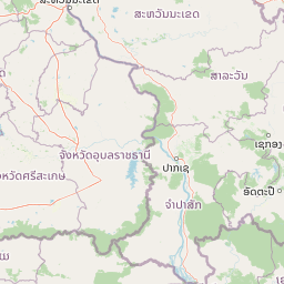
Map view of Pha Taem National Park

Use this park location map to pinpoint Pha Taem National Park in Thailand, understand its exact geographic position, and read its mapped placement within the surrounding landscape more clearly.

Pigeon | © OpenStreetMap contributors

Location context for Pha Taem National Park

Ubon Ratchathani Province
Park atlas

Browse the regional spread of conserved landscapes in Northeastern Thailand and adjacent areas for broader discovery.

Explore Nearby National Parks and Protected Areas Surrounding Pha Taem National Park
Continue your exploration from Pha Taem National Park by browsing other national parks and protected areas across Northeastern Thailand and the surrounding Mekong River corridor. Compare diverse conserved landscapes, from ancient rock art sites to dramatic cliff environments, to understand the region's broader geographic and ecological patterns.
National parkUbon Ratchathani Province

Kaeng Tana National Park: Mapped Protected Landscape in Ubon Ratchathani Province

Explore Thailand's national park geography and boundaries.

Kaeng Tana National Park is a designated national park located in Ubon Ratchathani Province, Thailand. This atlas-focused content helps users understand its unique protected landscape identity and geographic setting. Explore the mapped context of Kaeng Tana National Park, contributing to a structured understanding of conservation areas and natural terrain within Thailand's broader geography.

Area
80 km²
Established
1981
IUCN
II
Visitors
31.2K annual
National parkAmnat Charoen Province

Phu Sa Dok Bua National Park: National Park with Mapped Protected Boundaries

Explore protected landscapes in Amnat Charoen Province, Thailand.

Discover Phu Sa Dok Bua National Park, a designated national park situated within the geographic context of Amnat Charoen Province. This profile focuses on the park's protected area identity and its mapped boundaries, offering essential geographic information for atlas-based exploration and understanding its role within Thailand's conservation landscape.

Area
231 km²
Established
1992
IUCN
II
Visitors
1.8K annual
National parkSisaket Province

Khao Phra Wihan National Park: Protected Landscape and Archaeological Atlas Gateway

Explore dramatic red sandstone cliffs and historic Khmer ruins.

Khao Phra Wihan National Park in Sisaket Province, Thailand, is a protected landscape distinguished by its dramatic Pha Mo I Daeng red sandstone cliff and its role as a gateway to significant Khmer archaeological sites. This national park offers a deep dive into the region's unique geography, featuring rugged terrain, distinctive forest ecosystems, and prehistoric rock art. As a key entry point for understanding the Preah Vihear Temple's context, the park provides rich material for atlas-based exploration of border landscapes and historical terrain.

Area
130 km²
Established
1998
IUCN
II
Visitors
202.6K annual
National parkMukdahan Province

Phu Pha Thoep National Park: Mukdahan Province Protected National Park Geography

Explore its mapped protected landscape and regional context.

Phu Pha Thoep National Park is a designated national park in Thailand's Mukdahan Province, offering a distinct focus for geographic exploration. This resource provides detailed insights into its protected landscape, outlining mapped park boundaries and its integration within the regional geography. Understand the park's specific natural terrain and its value for structured atlas-style discovery, moving beyond simple location data to grasp its protected area significance.

Area
48 km²
IUCN
II
Visitors
47.6K annual
Relief
Upland
National parkRatanakiri province

Virachey National Park: Cambodia's Vast Highland Protected Landscape in Ratanakiri

Explore its remote montane forest ecosystems and diverse terrain.

Virachey National Park, Cambodia's largest national park, offers a profound glimpse into one of mainland Southeast Asia's last great wildernesses. Spanning remote highland terrain in Ratanakiri province, it features dramatic elevation changes from 400 to 1,500 meters, supporting diverse ecosystems including dense lowland forests, unique montane cloud forests, and upland savannahs. Its recognition as an ASEAN Heritage Park underscores its critical regional conservation value, making it a significant destination for understanding protected landscapes and their geographic context.

Area
3,380.57 km²
Established
1993
IUCN
II
Relief
Mountain
National parkRatanakiri province

Veun Sai, Siem Pang National Park: Northeastern Cambodia's Protected Lowland Forest Landscape

Mapped Boundaries and Primate Conservation Habitat

Veun Sai, Siem Pang National Park in Cambodia's Ratanakiri province is a vital protected area featuring expansive lowland evergreen and semi-evergreen forests. Its designation as a national park underscores its role in safeguarding critical habitat for diverse primate populations, notably the endangered Northern buffed-cheeked gibbon. The park's geography, characterized by gentle terrain and extensive forest cover, makes it a significant component of the region's biodiversity corridor and a key site for understanding Cambodia's natural landscapes.

Area
574.69 km²
Established
2016
IUCN
II
Relief
Lowland
National parkSakon Nakhon Province

Phu Pha Yon National Park: Protected Landscape and Regional Geography in Sakon Nakhon Province

Explore the mapped boundaries and natural terrain of this Thai national park.

Phu Pha Yon National Park, situated in Sakon Nakhon Province, is a protected national park offering a focused point for geographic exploration. This park entity serves as a component of Thailand's broader protected area network, with its mapped boundaries and natural landscape providing essential context for regional geography studies. Understanding Phu Pha Yon National Park through its geographic setting and protected status enhances atlas-based discovery and appreciation of its place within the Khorat Plateau.

Area
829 km²
Established
1988
IUCN
II
Visitors
5K annual
Watercolor illustration of a river flowing through a valley with green forests and distant mountains
National parkVietnam

Phong Nha, Kẻ Bàng National Park: Vietnam's Karst Terrain and Subterranean World

Explore protected landscapes, cave systems, and geological wonders.

Phong Nha, Kẻ Bàng National Park in Vietnam is a globally significant protected landscape, recognized by UNESCO for its exceptional karst topography and extensive cave networks. This national park features dramatic limestone mountains, deep river gorges, and some of the world's most impressive subterranean formations, offering a rich atlas of natural history and geological wonders to explore.

Area
857.54 km²
Established
2001
IUCN
II
Visitors
740K annual

Common questions about visiting, size, designation, and location context for Pha Taem National Park

Pha Taem National Park FAQs for park facts, access, geography, and protected area context
Find quick answers about Pha Taem National Park, including protected-area facts, park geography, trail and visitor context, and how the park fits into its surrounding country and regional landscape.
MoriAtlas Explorer

Continue Your Protected Areas Search Across the Global Atlas

Deepen your exploration by continuing the structured search for national parks and protected areas worldwide. Utilize the comprehensive filtering capabilities to compare different conservation landscapes and refine your understanding of global park geography. Discover more about the distribution and characteristics of protected natural areas.

Global natural geography
