

Mori Atlas logo
National parkPunta Izopo National Park

Discover the mapped protected area boundaries and natural geography of Punta Izopo National Park.

Punta Izopo National Park: Honduran National Park Landscape and Geographic Context

(Refugio de Vida Silvestre Punta Izopo)

Punta Izopo National Park serves as a key protected landscape within the Atlántida Department of Honduras. This national park offers a vital point of focus for understanding regional geography and mapped protected-area distributions. Explore its specific place within the broader Honduran atlas, examining the contours of its conservation lands and their natural setting.

Caribbean coastwetland reservemangrove ecosystemRamsar sitenational parkcoastal Honduras

Punta Izopo National Park

National park

Park overview

Structured park overview, official facts, and landscape profile for Punta Izopo National Park

Punta Izopo National Park park facts, protected area profile, and essential visitor context

Review the core facts for Punta Izopo National Park, including designation, size, terrain, visitor scale, habitats, and operating context in one park-focused overview.

About Punta Izopo National Park

Punta Izopo National Park represents an important component of Honduras's protected areas system, occupying a strategic position along the country's northern Caribbean coastline near the coastal city of Tela. The park's coastal setting places it within one of the most biodiverse regions in Central America, where the interaction between terrestrial and marine environments creates productive habitats for numerous species. As a national park established in 1992, it reflects Honduras's commitment to preserving its natural heritage and coastal ecosystems that define much of the country's northern landscape. The park's Ramsar Wetland designation in 1996 elevated its international profile and committed Honduras to maintaining the ecological integrity of its wetland habitats according to international conservation standards. The coastal location within the Atlántida department places this protected area within a region that has historically been important for both ecological and cultural reasons, as the Caribbean coast of Honduras supports communities whose livelihoods are intertwined with the marine and coastal environment.

Quick facts and research context for Punta Izopo National Park

Punta Izopo National Park is located on the northern Caribbean coast of Honduras in the Atlántida department, with the town of Tela serving as the nearest population center. The park covers 112 square kilometers of protected land and was officially established on January 1, 1992 as a national park under IUCN Category II protection. The area was designated as a Ramsar Wetland on March 20, 1996, receiving international recognition for its coastal ecosystem value under the official name Refugio de Vida Silvestre Punta Izopo. The park's terrain sits at an elevation of 118 meters and features the characteristic low-lying Caribbean coastal landscape typical of northern Honduras.

Protection and recognition

Documenting terrestrial protection scope and international Ramsar wetland status

Punta Izopo National Park Protection Status and Conservation Designations

Legal boundaries define the terrestrial protection scope of Punta Izopo National Park, safeguarding the geographic integrity of its coastal and forest landscapes. Official conservation databases register the area under the Ramsar designation of Refugio de Vida Silvestre Punta Izopo to track its global wetland significance.

International recognition

Protection details

Protection scope
Terrestrial
Transboundary protection
No
Park context

Deeper park guide and search-rich context for Punta Izopo National Park

Punta Izopo National Park history, landscape, wildlife, and travel context

Explore Punta Izopo National Park through its history, landscape character, ecosystems, wildlife, conservation priorities, cultural context, and seasonal travel timing in a structured park guide built for atlas discovery and search intent.

Why Punta Izopo National Park stands out

Punta Izopo is best known for its role as a coastal wetland protection area on Honduras's Caribbean shore, serving as a vital habitat for tropical coastal and migratory bird species. The park's mangrove ecosystems and protected coastal zones provide important nesting and feeding grounds for various bird species, while its Ramsar designation underscores its international significance as a wetland conservation area. The combination of Caribbean beach environments, mangrove forests, and wetland habitats creates a distinctive coastal protected area that supports biodiversity within the broader Mesoamerican region.

Punta Izopo National Park history and protected-area timeline

Punta Izopo National Park was established on January 1, 1992, becoming part of Honduras's growing national park system during a period when the country was expanding its protected area network. The designation came amid increased recognition of the ecological value of Honduras's Caribbean coastal zones, which had historically been less protected than the mountainous interior regions. The park's subsequent designation as a Ramsar Wetland on March 20, 1996, under the official name Refugio de Vida Silvestre Punta Izopo, marked a significant milestone in its conservation history. This international designation recognized the wetland's importance within the global network of protected wetlands and brought additional attention to the coastal ecosystems of northern Honduras.

Punta Izopo National Park landscape and geographic character

The landscape of Punta Izopo National Park is characterized by low-lying Caribbean coastal terrain at an elevation of approximately 118 meters. The park encompasses the diverse habitats found along a tropical coastline, including mangrove forests that transition from terrestrial to marine environments, coastal wetland areas, and beach zones along the Caribbean Sea. The terrain reflects the flat to gently undulating nature of the coastal plain in the Atlántida department, where river systems and tidal influences have shaped the distribution of habitats. The proximity to the Caribbean Sea defines much of the park's character, with the marine coastal environment influencing humidity, vegetation patterns, and the overall ecological character of the protected area.

Punta Izopo National Park ecosystems, habitats, and plant life

The natural environment of Punta Izopo National Park is defined by its position within the Caribbean coastal zone of Honduras, where tropical humid conditions support distinct coastal ecosystems. The park's wetland habitats, including mangroves and associated tidal zones, represent some of the most productive environments in the tropical zone, supporting complex food webs and providing critical habitat functions. The coastal location places the park within the broader Mesoamerican Barrier Reef System region, where the health of coastal ecosystems has implications for marine biodiversity. The mangroves found within the park serve important ecological functions including shoreline stabilization, nutrient cycling, and provision of nursery habitat for fish and invertebrate species.

Punta Izopo National Park wildlife and species highlights

Punta Izopo National Park supports wildlife populations characteristic of the Caribbean coastal zone of Honduras. The wetland and mangrove habitats provide important feeding and nesting areas for numerous bird species, including both resident tropical birds and migratory species that use the Central American coast as part of their migration routes. The mangrove ecosystems serve as productive nursery areas for various fish species and crustaceans that move between coastal waters and wetland environments during different life stages. While detailed species inventories are limited in the available sources, the park's Ramsar designation reflects its value as habitat for waterfowl and coastal bird species.

Punta Izopo National Park conservation status and protection priorities

The conservation significance of Punta Izopo National Park is underscored by its designation as a Ramsar Wetland, which recognizes the area as a wetland of international importance under the Ramsar Convention on Wetlands. This designation, conferred on March 20, 1996, reflects the site's ecological value and commits Honduras to maintaining the wetland's ecological character. The national park status under IUCN Category II provides additional protection framework, ensuring that the coastal ecosystems remain preserved for future generations. The park contributes to Honduras's representation within the regional network of protected areas that collectively support biodiversity conservation across Central America's Caribbean slope.

Punta Izopo National Park cultural meaning and human context

Punta Izopo National Park is located near the coastal city of Tela, which has historically been an important town on Honduras's Caribbean coast. The broader Atlántida department has a cultural character influenced by its coastal position, with communities whose traditions and livelihoods connect to the marine and coastal environment. While the park itself focuses on natural protection, the surrounding region reflects the cultural dynamics typical of Honduras's Caribbean coast, where mestizo and Garifuna communities have established connections to the land and sea over generations.

Top sights and standout views in Punta Izopo National Park

The primary highlights of Punta Izopo National Park include its status as a Ramsar-designated wetland offering internationally recognized coastal protection, its diverse mangrove and coastal wetland habitats supporting biodiversity, and its location along the Caribbean coast providing access to tropical coastal ecosystems. The park's proximity to Tela makes it accessible for visitors interested in experiencing the natural landscapes of Honduras's Caribbean coast, while its protected status ensures the preservation of these coastal environments for ecological and educational purposes.

Best time to visit Punta Izopo National Park

The best time to visit Punta Izopo National Park would generally align with the dry season typical of Honduras's Caribbean coast, though the park's wetland habitats can be explored year-round. The dry season period typically offers more comfortable conditions for outdoor exploration, while the wet season brings the characteristic humidity of the tropical zone. Visitors interested in birdwatching may find different species present during migration periods, when migratory birds use the coastal wetlands as resting and feeding areas along their routes.
Monthly climate preview

Analyzing thirty years of historical temperature and precipitation cycles in Atlántida

Punta Izopo National Park Climate History and Monthly Weather Averages

Measured long term records for Punta Izopo National Park reveal warm conditions where mean temperatures range from twenty-four to twenty-eight degrees Celsius. Accessing the complete twelve month climate profile clarifies how daily precipitation averages shift significantly between the drier and wetter months of the year.
Annual mean27 °C
25 °C28 °C
Jan25°
Feb25°
Mar26°
Apr27°
May28°
Jun28°
Jul28°
Aug28°
Sep28°
Oct27°
Nov26°
Dec25°
Warmest month
June

28 °C

Coolest month
January

24.6 °C

Wettest month
November

8 mm/day

Driest month
April

1.4 mm/day

Park location guide

Geography guide, regional context, and park location map for Punta Izopo National Park

Punta Izopo National Park park geography, regions, and map view in Honduras

Understand where Punta Izopo National Park sits in Honduras through a broader geographic reading of the surrounding landscape, nearby location context, and its mapped position within the national park landscape.

How Punta Izopo National Park fits into Honduras

Honduras, officially the Republic of Honduras, is a Central American nation with a predominantly Mestizo population. It gained independence in 1821 and operates as a unitary presidential republic. The country faces significant economic challenges, with over 70% of its population living in poverty, though it possesses valuable natural resources including minerals, coffee, and tropical fruits.

Wider geography shaping Punta Izopo National Park in Honduras

Honduras is located in Central America, bordering Guatemala to the west, El Salvador to the southwest, Nicaragua to the southeast, the Pacific Ocean to the south at the Gulf of Fonseca, and the Caribbean Sea to the north at the Gulf of Honduras. The terrain includes mountainous regions and coastal lowlands.

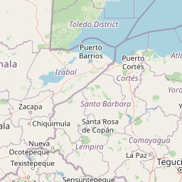
Map view of Punta Izopo National Park

Use this park location map to pinpoint Punta Izopo National Park in Honduras, understand its exact geographic position, and read its mapped placement within the surrounding landscape more clearly.

Pigeon | © OpenStreetMap contributors

Location context for Punta Izopo National Park

Atlántida Department
Park atlas

Discover nearby protected landscapes and compare wetland ecosystems along the Caribbean coast of Honduras

Explore Other National Parks and Protected Areas Near Punta Izopo National Park

Discover other national parks and protected areas located near Punta Izopo National Park, spanning the coastal wetlands and diverse landscapes across the Honduran Caribbean region. Compare the geographic spread of these protected landscapes and trace the interconnected wetland ecosystems, enhancing your atlas-style exploration of Central American conservation areas.
National parkHonduras
About 1.7 km away#1 closest

East

Jeannette Kawas National Park: A Protected Landscape within Honduran Geography

Explore the mapped boundaries and regional setting of this national park.

Jeannette Kawas National Park is a vital protected area whose geographic identity is central to understanding the natural landscape of Honduras. This page serves as a detailed exploration point, focusing on the park's mapped boundaries and its role within the country's protected lands atlas. Discover the unique aspects of this national park's terrain and its contribution to regional geographic context, providing a factual basis for atlas-driven learning.

Area
781.62 km²
Established
1994
IUCN
II
Relief
Highland
National parkAtlántida Department
About 39 km away#2 closest

East

Pico Bonito National Park: Honduran National Park with Mapped Protected Boundaries

Explore its geographic setting and protected landscape identity.

Pico Bonito National Park represents a vital protected area within Honduras, situated in the Atlántida Department. This canonical page focuses on its precise geographic features and the extent of its protected landscape. Users can engage with detailed map-based information and understand the park's significance within the broader context of Honduran geography and conservation atlas data.

Area
564.3 km²
Established
1987
IUCN
II
Relief
Mountain
National parkHonduras
About 72 km away#3 closest

South

Pico Pijol National Park: National Park within the Honduran Geographic Atlas

Explore its mapped boundaries and protected landscape context.

Pico Pijol National Park stands as a protected area within Honduras, offering critical insight into the nation's natural landscapes. This detail page provides essential context for understanding its geographic positioning and mapped boundaries, serving as a foundational element for broader atlas-based exploration of protected regions in Central America. Discover the park's unique identity as a national park and its contribution to regional geographic understanding.

Area
122.1 km²
Established
1987
IUCN
II
Relief
Mountain
National parkHonduras
About 96 km away#4 closest

South

Montaña de Yoro National Park: Honduran National Park Atlas and Protected Landscape Exploration

Understanding its mapped boundaries and regional geography.

This card details Montaña de Yoro National Park, a designated national park in Honduras, offering a focused look at its protected landscape. It provides essential geographic context, helping users to understand the park's mapped boundaries and its significance within the broader atlas of Honduran protected areas. Explore the specific terrain and regional setting that define Montaña de Yoro National Park.

Area
154.8 km²
Established
1987
IUCN
II
Relief
Mountain
National parkHonduras
About 99 km away#5 closest

West

Cusuco National Park: Protected Landscape and Geographic Atlas in Honduras

Explore mapped boundaries and regional natural terrain.

Cusuco National Park represents a crucial protected area within Honduras, offering rich detail for geographic exploration. This entry focuses on its identity as a national park, detailing its mapped boundaries and its contribution to the broader landscape context of Central America. Users can discover the specific protected lands and natural terrain that characterize this significant conservation site, building a foundational understanding for atlas-based study.

Area
234.4 km²
Established
1959
IUCN
II
Relief
Mountain
National parkLa Unión
About 107 km away#6 closest

Southeast

La Muralla National Park: Honduras National Park Geography and Mapped Boundaries

Explore the protected landscape and regional context.

La Muralla National Park represents a significant protected landscape within Honduras, offering valuable geographic data for atlas exploration. As a national park, its mapped boundaries and regional setting are key to understanding its conservation significance. This entry provides structured insight into the park's physical characteristics and its place within the broader Honduran geography, ideal for detailed landscape analysis.

Area
210.35 km²
Established
1993
IUCN
II
Scope
Terrestrial
National parkHonduras
About 109 km away#7 closest

Southwest

Cerro Azul Meámbar National Park: Protected Area and Mapped Landscape Context

Explore its geography and national park boundaries in Honduras.

Cerro Azul Meámbar National Park offers a unique perspective on Honduras's protected lands and national park geography. This entry provides an atlas-style overview of its mapped boundaries and its regional landscape context, crucial for understanding the distribution of conservation areas within Central America. Gain insight into its protected area status and geographic identity for focused landscape discovery.

Area
300 km²
Established
1987
IUCN
II
Relief
Mountain
National parkRoatán
About 127 km away#8 closest

Northeast

Port Royal National Park National Park: Mapped Protected Landscape on Roatán

Explore its geographic context and park boundaries.

Port Royal National Park, situated on Roatán, Honduras, offers a distinct protected landscape for geographic exploration. As a National Park, its mapped boundaries define a significant area for understanding regional geography and conservation landscapes. Discover the park's identity through its position within Roatán and its contribution to a structured atlas of protected natural areas.

Area
5 km²
Established
2010
IUCN
II
Climate
Tropical

Common questions about visiting, size, designation, and location context for Punta Izopo National Park

Punta Izopo National Park FAQs for park facts, access, geography, and protected area context

Find quick answers about Punta Izopo National Park, including protected-area facts, park geography, trail and visitor context, and how the park fits into its surrounding country and regional landscape.
MoriAtlas Explorer

Continue Your Protected Areas Search Across the Global Atlas

Deepen your exploration by continuing the structured search for national parks and protected areas worldwide. Utilize the comprehensive filtering capabilities to compare different conservation landscapes and refine your understanding of global park geography. Discover more about the distribution and characteristics of protected natural areas.

Global natural geography