Mori Atlas logo
Nature reserveRéserve naturelle régionale du Peuptu de la Combe Chaignay

A recently classified nature reserve featuring distinctive limestone combe terrain within the Côte-d'Or department.

Réserve naturelle régionale du Peuptu de la Combe Chaignay: Protected Landscape and Regional Geography

The Réserve naturelle régionale du Peuptu de la Combe Chaignay represents a key addition to the regional protected area network in the Bourgogne-Franche-Comté region. Covering 36.6 hectares in the commune of Vernot, this nature reserve safeguards specific calcareous habitats nestled within the steep, narrow limestone valleys known as combes. Its geographic setting highlights the traditional rural landscape of the northern Burgundy plateau, where erosional landforms and mixed terrain create important, locally concentrated ecological zones.

regional nature reservelimestone landscapecombeBurgundyCôte-d'OrBourgogne-Franche-Comté

Réserve naturelle régionale du Peuptu de la Combe Chaignay

Nature reserve

Park overview

Structured park overview, official facts, and landscape profile for Réserve naturelle régionale du Peuptu de la Combe Chaignay

Réserve naturelle régionale du Peuptu de la Combe Chaignay park facts, protected area profile, and essential visitor context

Review the core facts for Réserve naturelle régionale du Peuptu de la Combe Chaignay, including designation, size, terrain, visitor scale, habitats, and operating context in one park-focused overview.

About Réserve naturelle régionale du Peuptu de la Combe Chaignay

The Réserve naturelle régionale du Peuptu de la Combe Chaignay sits in the Côte-d'Or department, in the Bourgogne-Franche-Comté region of east-central France. Its territory lies within the commune of Vernot, a small rural municipality characteristic of the northern Burgundian countryside, where limestone-dominated plateaus alternate with narrow wooded valleys and patches of farmland.

With an area of 36.6 hectares, the reserve is modest in scale, consistent with the typical footprint of regional nature reserves in France. These reserves are generally designed to protect specific local natural features, such as ecologically rich woodlands, herb-rich meadows, limestone grasslands, wetland pockets, or particular geological exposures, rather than to manage vast continuous landscapes. The Peuptu de la Combe Chaignay reserve fits this model: it concentrates protection on a defined site whose name itself suggests a particular landform, with "combe" referring to a steep-sided valley typical of the limestone regions of eastern France.

The reserve was officially created on 12 December 2025 following a deliberation of the Regional Council of Bourgogne-Franche-Comté, entering the French system of aires protégées under the legal status of Réserve naturelle régionale, registered as RNR348. Its IUCN Category IV classification indicates a focus on the management of habitats and species through active intervention where appropriate, while maintaining the underlying natural character of the site.

Because detailed published descriptions of the reserve's flora, fauna, and specific ecological values are still emerging, the site today is best understood as a newly established component of Burgundy's regional conservation network, adding protected-area coverage in a department already known for its rich natural and cultural landscape.

Quick facts and research context for Réserve naturelle régionale du Peuptu de la Combe Chaignay

Established in December 2025 by the Bourgogne-Franche-Comté Regional Council, the reserve covers 36.6 hectares on the commune of Vernot in Côte-d'Or, northern Burgundy. It is classified as a Réserve naturelle régionale (RNR348) and carries an IUCN Category IV designation, reflecting a management approach centered on the protection of specific habitats and species. Its location places it within the broader Burgundian landscape of limestone plateaus, forested combes, and mixed agricultural land.

Protection and recognition

Documented terrestrial conservation scope and official designation records

Réserve Naturelle Régionale du Peuptu de la Combe Chaignay Protection Status

Terrestrial protection status and documented conservation parameters define the official management scope for Réserve naturelle régionale du Peuptu de la Combe Chaignay. Structured designation records outline the verified regulatory framework governing this protected natural landscape.

Protection details

Protection scope
Terrestrial
Park context

Deeper park guide and search-rich context for Réserve naturelle régionale du Peuptu de la Combe Chaignay

Réserve naturelle régionale du Peuptu de la Combe Chaignay history, landscape, wildlife, and travel context

Explore Réserve naturelle régionale du Peuptu de la Combe Chaignay through its history, landscape character, ecosystems, wildlife, conservation priorities, cultural context, and seasonal travel timing in a structured park guide built for atlas discovery and search intent.

Why Réserve naturelle régionale du Peuptu de la Combe Chaignay stands out

The reserve is notable for being one of the most recently created regional nature reserves in Bourgogne-Franche-Comté, adding a small but targeted protected footprint to the Côte-d'Or's network of natural areas. Its setting on the edge of Burgundy's limestone uplands gives it the kind of localized habitat value that the French regional reserve system is specifically designed to safeguard.

Réserve naturelle régionale du Peuptu de la Combe Chaignay history and protected-area timeline

The reserve is a very recent addition to France's protected-area system. Its creation was decided by the Regional Council of Bourgogne-Franche-Comté on 12 December 2025, establishing the site as a Réserve naturelle régionale under the regional nature reserve framework. The specific institutional, community, and ecological context that led to the classification is not yet documented in publicly available detail, but the timing reflects the continuing expansion of regional-level natural protection across Burgundy.

As with most new French regional nature reserves, the designation typically follows local conservation efforts and formal review processes through the regional council, with the site then entering management under a designated managing body within the regional reserves network.

Réserve naturelle régionale du Peuptu de la Combe Chaignay landscape and geographic character

The reserve lies within the Côte-d'Or, a department defined by its Jurassic limestone formations, gently rolling plateaus, and the characteristic combes, the steep, narrow valleys incised into the limestone uplands. The site's name refers to one such landform, suggesting terrain shaped by the interplay of hard limestone layers and erosion-driven valley formation that is typical of this part of Burgundy.

Surrounding land use around the commune of Vernot reflects the broader northern Burgundian pattern of mixed countryside, with woodland on the steeper slopes and valley sides, agricultural fields on the more workable plateaus and broader valley floors, and small clustered settlements tied to traditional rural land use. This mosaic provides the kind of varied local environment that regional reserves are often designed to protect at the scale of a single site.

Réserve naturelle régionale du Peuptu de la Combe Chaignay ecosystems, habitats, and plant life

The ecological interest of the reserve is tied to its position within the limestone-dominated terrain of the Côte-d'Or. Such sites typically support habitats such as calcareous grasslands, limestone scrub, deciduous woodland on rocky slopes, and transitional zones between forest and open land, which together sustain specialized plant communities adapted to thin, dry, base-rich soils.

The "combe" landform referenced in the reserve's name is characteristic of the region: narrow, often shaded valleys that create distinct microclimates and support different vegetation from the surrounding plateaus. These settings frequently harbor elevated botanical diversity in a small area and provide refuge for species associated with traditional, lightly disturbed rural landscapes.

Réserve naturelle régionale du Peuptu de la Combe Chaignay wildlife and species highlights

Specific fauna records for the reserve are not yet documented in publicly available sources. However, the habitat mosaic typical of Côte-d'Or combes, including woodland, scrub, calcareous grassland, and edge habitats, generally supports a varied invertebrate fauna, common woodland and edge bird species, and small mammals associated with mixed agricultural and forested countryside in Burgundy.

Réserve naturelle régionale du Peuptu de la Combe Chaignay conservation status and protection priorities

As a Réserve naturelle régionale, the Peuptu de la Combe Chaignay site enters the French regional conservation framework specifically designed to protect locally significant natural areas that may not fit within larger national park or national reserve boundaries. Its IUCN Category IV designation underlines a management orientation toward the maintenance of particular habitats and species, often in landscapes shaped by long human presence.

The reserve adds a small but targeted protected footprint to the broader conservation network of Bourgogne-Franche-Comté, contributing to the regional objective of maintaining ecological continuity and protecting habitat features characteristic of the northern Burgundian landscape.

Réserve naturelle régionale du Peuptu de la Combe Chaignay cultural meaning and human context

The reserve lies within a region with deep rural and viticultural traditions, where the landscape has been shaped over centuries by a mix of agriculture, forestry, and small-village life. The commune of Vernot and surrounding Côte-d'Or villages are part of the broader Burgundian cultural geography, in which local landforms such as combes have long influenced settlement patterns, land use, and traditional knowledge of the natural environment.

Top sights and standout views in Réserve naturelle régionale du Peuptu de la Combe Chaignay

Among the reserve's defining qualities are its very recent protection status, giving it a distinctive position among French regional nature reserves, and its location within a combe landform in the Côte-d'Or, an area recognized for its ecologically rich limestone terrain. Its modest 36.6-hectare footprint reflects the targeted, site-specific approach of the regional reserves network, and its IUCN Category IV classification signals an active habitat and species management orientation within Burgundy's broader conservation framework.
Monthly climate preview

Long term temperature and precipitation patterns across representative protected coordinates

Réserve naturelle régionale du Peuptu de la Combe Chaignay Climate and Monthly Weather Normals

Representative coordinates record measured annual temperature swings from sub-zero winter minimums to warm summer maximums alongside steady daily precipitation averages. Examining the complete twelve month climate profile reveals detailed monthly fluctuations across this protected landscape.
Annual mean10 °C
1 °C19 °C
Jan
Feb
Mar
Apr
May13°
Jun17°
Jul19°
Aug19°
Sep15°
Oct10°
Nov
Dec
Warmest month
July

18.9 °C

Coolest month
January

1.1 °C

Wettest month
November

2.6 mm/day

Driest month
March

1.7 mm/day

Park location guide

Geography guide, regional context, and park location map for Réserve naturelle régionale du Peuptu de la Combe Chaignay

Réserve naturelle régionale du Peuptu de la Combe Chaignay park geography, regions, and map view in France

Understand where Réserve naturelle régionale du Peuptu de la Combe Chaignay sits in France through a broader geographic reading of the surrounding landscape, nearby location context, and its mapped position within the national park landscape.

How Réserve naturelle régionale du Peuptu de la Combe Chaignay fits into France

France is a unitary semi-presidential republic and one of the world's largest economies. It borders Belgium, Luxembourg, Germany, Switzerland, Italy, Monaco, Andorra, and Spain, with a maritime border to the United Kingdom. The country is known for its cultural influence, art, cuisine, and political history spanning centuries.

Wider geography shaping Réserve naturelle régionale du Peuptu de la Combe Chaignay in France

France is located in Western Europe. Metropolitan France extends from the Rhine to the Atlantic Ocean and from the Mediterranean Sea to the English Channel and North Sea. The country borders Belgium, Luxembourg, Germany, Switzerland, Italy, Monaco, Andorra, Spain, and has a maritime border with the United Kingdom.

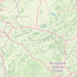
Map view of Réserve naturelle régionale du Peuptu de la Combe Chaignay

Use this park location map to pinpoint Réserve naturelle régionale du Peuptu de la Combe Chaignay in France, understand its exact geographic position, and read its mapped placement within the surrounding landscape more clearly.

Pigeon | © OpenStreetMap contributors

Location context for Réserve naturelle régionale du Peuptu de la Combe Chaignay

Bourgogne-Franche-Comté
Park atlas

Compare surrounding protected landscapes and regional nature reserves

Parks Near Réserve naturelle régionale du Peuptu de la Combe Chaignay

Browsing other protected areas near Réserve naturelle régionale du Peuptu de la Combe Chaignay reveals connected limestone habitats and regional conservation networks. Evaluating adjacent terrain offers deeper geographic context across the surrounding Burgundian uplands.
A watercolor painting of a pastoral landscape featuring a calm river winding through green fields and forests with rolling mountains in the background, set against a soft sunset sky.
Nature reserveBourgogne-Franche-Comté
About 6.7 km away#1 closest

Southwest

Réserve naturelle régionale du Val-Suzon: Protected Landscape and Geographic Atlas

Wooded limestone valleys in the Bourgogne-Franche-Comté region

Spanning the meandering Suzon river, this large regional nature reserve provides a essential look at the limestone plateaus and deciduous woodlands of Côte-d'Or. The area serves as a primary reference for regional biodiversity, containing dry grasslands, rocky slopes, and sensitive tufa springs protected within its defined borders. This resource outlines the physical terrain and conservation significance of the territory for those mapping the natural landscape of eastern France.

Area
29.806 km²
Established
2011
Relief
Upland
Climate
Temperate
Nature reserveBourgogne-Franche-Comté
About 17 km away#2 closest

South

Réserve naturelle régionale de la grotte du Contard: Protected Karst and Cave Geography

Regional natural reserve in the Bourgogne-Franche-Comté landscape

Located near Dijon, the Réserve naturelle régionale de la grotte du Contard is a protected area focused on preserving the karst features and geological heritage of the Côte-d'Or. This site serves as a vital example of subterranean habitat conservation, showcasing the unique interaction between water-sculpted limestone cavities and the surrounding plateau terrain. Explore the geographic extent of this reserve and understand its role within the regional natural reserve network.

Area
0.259 km²
Established
2025
IUCN
IV
Climate
Temperate
A watercolor painting of a rolling rural landscape with grassy hills, woodlands, and a winding stream, rendered in soft pastel greens, yellows, and pinks.
Nature reserveGrand Est
About 21 km away#3 closest

North

Réserve naturelle régionale des pelouses et bois de Villemoron: Protected Area and Map

Regional nature reserve in the Grand Est, France

This protected area provides a rare glimpse into the limestone-based geography of the Haute-Marne department. Featuring a structured mix of oak forests and open calcareous grasslands, the reserve serves as an essential habitat refuge within the larger landscape of the Grand Est region. Use our mapped data to trace the boundaries and features of this uniquely managed natural environment.

Area
0.87 km²
Established
2015
IUCN
IV
Relief
Upland
Watercolor illustration of a forested landscape with rolling hills, distant mountains, and a sky with soft pastel colors
National parkFrance
About 25 km away#4 closest

North

Forêts National Park: A Protected Landscape of Lowland Deciduous Forests

Explore its unique geography and protected forest ecosystems.

Delve into Forêts National Park, a significant protected area in northeastern France dedicated to preserving lowland deciduous forests and their associated biodiversity. This park represents a unique atlas entry for understanding mapped protected lands, featuring extensive broad-leaved forest tracts, diverse wetlands, and limestone grasslands across the Grand Est and Bourgogne-Franche-Comté regions. Discover the geographic identity of this conservation landscape and its role within the Paris Basin's terrain.

Area
560 km²
Established
2019
IUCN
II
Relief
Lowland
Watercolor painting of a green, rolling landscape showing forested hills in varying shades of light green and soft earth tones against a white background.
Nature reserveBourgogne-Franche-Comté
About 30 km away#5 closest

South

Réserve naturelle nationale de la combe Lavaux-Jean Roland Protected Area Geography

Limestone cliff landscapes in Bourgogne-Franche-Comté

Spanning over 400 hectares, this nature reserve showcases a dramatic interplay of steep limestone walls and scree slopes. The geographic profile highlights the contrast between north-facing forest and sunlit grasslands, creating a vital corridor for endemic species within the Burgundy landscape.

Area
4.87 km²
Established
2004
IUCN
IV
Relief
Upland
Nature reserveHaute-Marne
About 54 km away#6 closest

Tufière de Rolampont Nature Reserve: Travertine Cascades and Geological Heritage in Haute-Marne

A rare living limestone formation in the Grand Est region of France

Tufière de Rolampont offers a window into the evolution of calcareous wetland ecosystems within the Champagne plateau. Visitors observe a process of natural stone creation where mineral-rich water encrusts living mosses, resulting in the stepped terraces that define this protected landscape. This site serves as a vital laboratory for understanding the intersection of hydrological heritage and unique botanical habitats.

Area
0.126 km²
Established
1982
Relief
Lowland
Climate
Temperate
Nature reserveBourgogne-Franche-Comté
About 66 km away#7 closest

East

Réserve naturelle régionale de la grotte de Beaumotte: Protected Karst and Cave Landscapes

A regional nature reserve focused on subterranean conservation.

Located in the Haute-Saône department, this regional nature reserve protects a critical limestone cave system that supports complex subterranean ecosystems and bat species of regional concern. The site occupies a modest surface area on the edge of the Monts de Gy massif, yet provides significant geological and ecological value through its horizontal gallery network and captured springs.

Area
0.088 km²
Established
2015
IUCN
IV
Relief
Upland
A soft watercolor painting of a green, hilly landscape with small groups of trees, set against a white background.
Nature reserveBourgogne-Franche-Comté
About 69 km away#8 closest

East

Réserve naturelle régionale du vallon de Fontenelay: Protected Area Atlas and Map

High-density marly grasslands and wetland seepage slopes

Situated in the Haute-Saône department, this nature reserve features a distinct valley landscape formed by marly soil and limestone. Explore the site's rich biodiversity including alkaline marshes and its significant role in the regional conservation network for northeastern France.

Area
0.416 km²
Established
2010
IUCN
IV
Relief
Upland

Common questions about visiting, size, designation, and location context for Réserve naturelle régionale du Peuptu de la Combe Chaignay

Réserve naturelle régionale du Peuptu de la Combe Chaignay FAQs for park facts, access, geography, and protected area context

Find quick answers about Réserve naturelle régionale du Peuptu de la Combe Chaignay, including protected-area facts, park geography, trail and visitor context, and how the park fits into its surrounding country and regional landscape.
MoriAtlas Explorer

Continue Your Protected Areas Search Across the Global Atlas

Deepen your exploration by continuing the structured search for national parks and protected areas worldwide. Utilize the comprehensive filtering capabilities to compare different conservation landscapes and refine your understanding of global park geography. Discover more about the distribution and characteristics of protected natural areas.

Global natural geography