
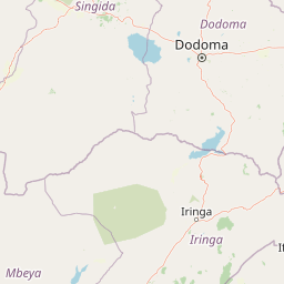
Rivers
Park geography
Mapped boundaries, environmental classification, and inland water features
Geographic Profile and Landscape Analysis of Ruaha National Park in Tanzania
The geography of Ruaha National Park encompasses 20,226 square kilometers of diverse terrain within Tanzania. This profile maps the spatial distribution of riverine corridors, wetlands, and grasslands, providing a structured look at the regional environment and the physical landscape features contained within the park boundaries.
Related tags
Southern TanzaniaMiombo WoodlandLion ConservationRiver EcosystemLarge Predators
Tanzania's remote wilderness sanctuary of the Great Ruaha River
Ruaha National Park
Ruaha National Park is one of Tanzania's largest and most remote national parks, encompassing a vast wilderness area of approximately 20,226 square kilometers in the country's southern highlands. The park was officially established in 1964 and dramatically expanded in 2008 when the Usangu Game Reserve and associated wetlands were incorporated, creating a contiguous protected landscape within the broader 45,000 square kilometer Rungwa-Kizigo-Muhesi ecosystem. The park derives its name from the Great Ruaha River, which flows along its southeastern boundary and serves as thelifeblood of the region, sustaining wildlife populations through the dry season and providing the focal point for game-viewing activities. The park lies roughly 130 kilometers west of the regional capital of Iringa and can be accessed by a network of dirt roads, with two airstrips serving visitors at Msembe and Jongomeru. The protected area represents a critical conservation stronghold in East Africa, protecting diverse habitats ranging from rocky highlands and dense woodlands to riverine forests and expansive savannas.
- Location
- Tanzania
- Park type
- National park
- Established
- 1964
- Area
- 20,226 km²
Location overview
National jurisdiction and territorial attributes within Tanzania
National Park Geography: Ruaha National Park in Tanzania
Ruaha National Park is located entirely within the country of Tanzania. High-level records confirm its status as an inland protected territory with no coastal, marine, or transboundary coordinates.
- Countries
- Tanzania
- Primary location
- Tanzania
- Geographic setting
- Inland
Boundary and coordinates
Mapped perimeter geometry and derived spatial measurements
Ruaha National Park Boundary Map and Spatial Extent
Interactive boundary mapping defines the spatial extent and regional footprint of the protected area. Accompanying measurements supply surface area figures, coordinate limits, and geographic spans for spatial analysis.
- Boundary area
- 19,779.2 km²
- Boundary perimeter
- 788.7 km
- Northernmost point
- 6.8948° S
- Southernmost point
- 8.7014° S
- Easternmost point
- 35.41° E
- Westernmost point
- 33.5867° E
- Geographic centre
- 7.8238° S, 34.4239° E
- North–south span
- 199.8 km
- East–west span
- 201.1 km
Terrain and natural features
Lowland relief classifications and recorded hydrographic features
Ruaha National Park Terrain and Named Natural Features
Ruaha National Park features stored lowland relief classifications alongside recorded named natural features within the terrain boundaries. Linked feature cards provide names, types, measurements, and spatial relationships where recorded.
Selected named natural features
Ponds
Waterhole
Rivers
Mdonia River
Rivers
Great Ruaha River
Viewpoints
Korongo Viewpoint
Rivers
Ripera
Environmental setting
Interpreting tropical lowland relief, major water bodies, and seasonal habitats
Ruaha National Park Environmental Classifications and Physical Setting
Recorded landscape features, habitat types, and climatic zones frame the physical setting of Ruaha National Park through complementary interpretive categories. Stored classifications connect directly to relevant atlas destinations to trace matching regional protected areas.
- Relief
- Lowland
- Climate
- Tropical
- Water
- Major water bodies
- Seasonality
- Seasonal
Landscape features
Rivers · Wetland · Grassland
Habitat types
Grassland · Savanna · Wetland · Riverine habitat
Park atlas
Trace the regional spread of conservation landscapes in Tanzania, comparing diverse park geography and adjacent protected areas.
Discover Other National Parks and Protected Landscapes Near Ruaha National Park
Continue your exploration of Tanzania's protected areas by discovering national parks and conservation landscapes surrounding Ruaha National Park. Compare the unique geographic features, wildlife habitats, and conservation efforts across the region to broaden your atlas-based understanding of East African wilderness.
National parkNjombe Region
About 46 km away#1 closest
Southwest

Kitulo National Park: National Park within Njombe Region's Geographic Atlas
Mapped protected area boundaries and regional landscape context.
Kitulo National Park represents a distinct national park within the geographic atlas of Tanzania's Njombe Region. This page offers a focused exploration of its protected landscape identity, highlighting its mapped boundaries and contributing to a broader understanding of regional geography. It is designed for users seeking detailed, atlas-centric information about Kitulo National Park's specific natural landscape and its position within the surrounding terrain.
- Area
- 413 km²
- Established
- 2005
- IUCN
- II
- Visitors
- 409 annual
National parkKilolo District
About 151 km away#2 closest
East
Udzungwa Mountains National Park: Kilolo District Protected Area & Landscape Atlas
Explore mapped boundaries and regional geography for this Tanzanian national park.
Udzungwa Mountains National Park serves as a vital protected area within Kilolo District, offering a specific point of geographic focus for atlas exploration. Users can investigate its mapped boundaries and understand its role within the regional landscape context. This detailed entry provides essential data for comprehending the park's protected status and its contribution to Tanzania's network of natural areas.
- Area
- 1,990 km²
- Established
- 2012
- IUCN
- II
- Relief
- Mountain
National parkMalawi
165 km away#3 closest
South

Nyika National Park: Malawi National Park Atlas Exploration and Protected Landscape
Discover geographic context and mapped boundaries of this protected area.
Nyika National Park serves as a core entry for understanding Malawi's protected areas and natural landscapes through an atlas lens. Explore the park's designation as a national park, its geographic positioning within Malawi, and the mapped context that defines its protected status. This detail page provides a foundational view for appreciating the park's landscape and its contribution to the regional protected lands overview.
- Area
- 3,134 km²
- Established
- 1966
- IUCN
- II
- Relief
- Highland
National parkTanzania
186 km away#4 closest
Southeast
Nyerere National Park: Tanzania's Immense Protected Area and Rufiji River Landscape
Explore the savanna and river delta geography of this national park.
Nyerere National Park represents one of Tanzania's most significant protected areas, sprawling across southeastern regions and offering a glimpse into largely untouched wilderness. The park's identity is deeply intertwined with the Rufiji River and its expansive delta, home to one of the world's largest mangrove forest systems. As a national park, its vastness and diverse terrain provide critical habitat, making it a key point for understanding protected land distribution and regional landscape context within Tanzania.
- Area
- 30,893 km²
- Established
- 2019
- IUCN
- II
- Relief
- Mixed relief
National parkMorogoro Region
About 191 km away#5 closest
East
Mikumi National Park: East African Savannah Protected Landscape in Morogoro Region
Mapped boundaries and regional geography for a key Tanzanian national park.
Mikumi National Park, a vital protected area in Tanzania's Morogoro Region, offers a classic savannah experience with iconic baobab trees and diverse wildlife populations. This national park is distinguished by its extensive alluvial plains, shaped by the Mkata River basin, and its significant role as a wilderness corridor connecting with the larger Selous Game Reserve. The park's terrain includes Malundwe Mountain and views of the Uluguru Mountains, providing a rich geographic backdrop for understanding East African protected lands and their atlas-style distribution.
- Area
- 3,230 km²
- Established
- 1964
- IUCN
- II
- Visitors
- 41.7K annual
National parkZambia
About 222 km away#6 closest
Southwest

Nyika National Park: A Zambian National Park for Mapped Landscape Discovery
Explore its protected area boundaries and regional geographic context.
Nyika National Park in Zambia is a critical protected landscape offering valuable insights for geographic exploration. As a national park, its mapped terrain and regional context provide a distinct point of study within the country's atlas. Users can investigate the park's specific geographic features and its contribution to Zambia's conservation landscapes, enriching their understanding of protected areas.
- Relief
- Highland
- Climate
- Subtropical
- Access
- Moderate access
- Scope
- Terrestrial
Wildlife reserveMalawi
About 261 km away#7 closest
South
Vwaza Marsh Wildlife Reserve: Geographic Atlas and Protected Landscape Overview
A lowland wilderness reserve in northern Malawi
Spanning roughly 1,000 square kilometers, Vwaza Marsh Wildlife Reserve provides a unique contrast to the surrounding highlands through its flat topography, seasonal wetlands, and dense mopane forests. This destination serves as a vital corridor for large mammals moving across the border, offering a window into the complex interplay of water-focused ecology and savanna-woodland habitats in Southeastern Africa.
- Area
- 1,000 km²
- IUCN
- IV
National parkKatavi Region
About 284 km away#8 closest
West
Katavi National Park: A Vast Protected Landscape in Tanzania's Katavi Region
Explore its unique floodplains, seasonal wetlands, and wildlife spectacles.
Katavi National Park is a significant national park located in the Katavi Region of Tanzania, spanning over 4,471 square kilometers. This remote protected area is characterized by extensive floodplains, the vital Katuma River system, and seasonal lakes like Lake Katavi and Lake Chada, which undergo dramatic changes throughout the year. The park's geography supports a dynamic ecosystem renowned for its large wildlife populations, including spectacular hippo gatherings during dry periods and vast herds of buffaloes and elephants roaming its uncrowded savannas. Katavi offers an unparalleled glimpse into a wild, untamed African landscape.
- Area
- 4,471 km²
- Established
- 1974
- IUCN
- II
- Visitors
- 1.5K annual
MoriAtlas Explorer
Continue Exploring Ruaha National Park's Mapped Landscape and Tanzanian Geography
Delve deeper into the geographic specifics of Ruaha National Park. Use this area to trace its protected landscape boundaries, understand its regional context within Tanzania, and gain a richer appreciation for its role in the atlas of protected natural areas. Gain structured insight into the park's mapped terrain and its geographic identity.
Browse next
Global natural geography
Explore related park routes
Explore MoriAtlas Global ParksBrowse All MoriAtlas ParksGlobal Park Map DiscoveryMoriAtlas: Browse All CountriesBrowse All MoriAtlas ContinentsNational Park Environment AtlasGrand Canyon National Park AtlasYellowstone National Park AtlasYosemite National Park Atlas and GeographySerengeti National Park AtlasGalápagos National Park Protected LandscapeBanff National Park Geography and AtlasKruger National Park Atlas EntryUluṟu-Kata Tjuṯa National Park AtlasExplore Uluru-Kata Tjuta National Park GeographyPlitvice Lakes National Park AtlasFiordland National Park Protected LandscapeGreat Smoky Mountains National Park AtlasAfghanistan National Parks and Protected AreasAlbania National Parks and Protected AreasAlgeria National Parks and Protected AreasAmerican Samoa National Parks and Protected AreasAndorra National Parks and Protected AreasAngola National Parks and Protected AreasAntarctica National Parks and Protected AreasAntigua and Barbuda Park List