Mori Atlas logo
Wildlife reserveVwaza Marsh Wildlife Reserve

Explore the geographic terrain and wetland boundaries of this essential Malawian wilderness reserve.

Vwaza Marsh Wildlife Reserve: A Mapped Protected Area of Floodplains and Miombo Woodlands

Vwaza Marsh Wildlife Reserve occupies a vast expanse of low-lying terrain in Malawi, where seasonal floodplains and intricate wetland systems define the regional geography. This protected area serves as a critical buffer between miombo and mopane woodlands, supporting diverse mammalian movement and extensive waterbird habitats. The reserve acts as a transboundary node for ecological activity, connecting directly with protected landscapes beyond the border through its unique mosaic of natural terrain.

wetlandsmarshlandfloodplainsmiombo woodlandmopane woodlandbirdwatching

Vwaza Marsh Wildlife Reserve

Wildlife reserve

Park overview

Structured park overview, official facts, and landscape profile for Vwaza Marsh Wildlife Reserve

Vwaza Marsh Wildlife Reserve park facts, protected area profile, and essential visitor context

Review the core facts for Vwaza Marsh Wildlife Reserve, including designation, size, terrain, visitor scale, habitats, and operating context in one park-focused overview.

About Vwaza Marsh Wildlife Reserve

Vwaza Marsh Wildlife Reserve is one of Malawi's largest protected landscapes, anchoring a roughly 1,000 square kilometer block of land between the high Nyika Plateau to the northwest and the broad floodplains of the South Rukuru River. While much of the attention on Malawi's protected areas focuses on the montane grasslands of Nyika or the lakeshore scenery of Lake Malawi, Vwaza offers something distinct: a predominantly flat, low-lying reserve shaped by seasonal flooding, miombo woodland, and mopane scrub.

The reserve's wetlands are central to its character. Marshes, floodplains and seasonal waterways transform the landscape through the year, supporting a rich community of waterbirds and concentrating wildlife around reliable water sources such as Lake Kazuni. Surrounding the wetland core, mopane and miombo woodlands cover much of the terrain, with the eastern side of the reserve rising into hillier country. This combination of wetland and woodland habitats creates the kind of habitat mosaic that supports both resident and migratory species.

Vwaza also occupies an important position within the wider regional conservation landscape. The reserve borders Zambia, and animals regularly move between Vwaza and the North Luangwa National Park, meaning that wildlife populations here are part of a much broader transboundary system. This ecological continuity, combined with the reserve's relative remoteness, has helped preserve a wilderness feel even as habitat pressures increase elsewhere in the region. For visitors and researchers, Vwaza offers a quieter, less-developed counterpoint to Malawi's more heavily visited parks, alongside genuinely significant ecological value.

Quick facts and research context for Vwaza Marsh Wildlife Reserve

Vwaza Marsh Wildlife Reserve is a national game reserve in Malawi classified as an IUCN Category IV protected area, recognizing its role in managing habitats and species. It spans approximately 1,000 square kilometers of predominantly low-lying land southeast of the Nyika Plateau and north of the South Rukuru River floodplains.

The reserve is defined by a mixture of miombo and mopane woodland interspersed with extensive marshy wetlands and river systems. Lake Kazuni is a notable feature within the reserve and supports a significant hippopotamus population. Vwaza also serves as an important transboundary wildlife area, with animals crossing between Malawi and the North Luangwa National Park in Zambia. Botanical surveys have recorded nearly 400 species of vascular plants across more than seventy families.

Protection and recognition

Examine documented conservation scope and international recognition records for Vwaza Marsh Wildlife Reserve.

Vwaza Marsh Wildlife Reserve Protection Status and Recognition Data

Vwaza Marsh Wildlife Reserve protection status details provide clear insight into documented conservation parameters and reserve governance. Structured records outline the formal administrative framework associated with this protected natural area.

Protection details

Transboundary protection
No
Park context

Deeper park guide and search-rich context for Vwaza Marsh Wildlife Reserve

Vwaza Marsh Wildlife Reserve history, landscape, wildlife, and travel context

Explore Vwaza Marsh Wildlife Reserve through its history, landscape character, ecosystems, wildlife, conservation priorities, cultural context, and seasonal travel timing in a structured park guide built for atlas discovery and search intent.

Why Vwaza Marsh Wildlife Reserve stands out

Vwaza Marsh Wildlife Reserve is best known for its expansive wetland and floodplain systems set against a backdrop of mopane and miombo woodland, a combination considerably different from Malawi's highland parks. Lake Kazuni and the surrounding marshes are central to the reserve's identity, attracting large flocks of waterbirds including Goliath herons, openbill storks and the rare white-winged starling. The reserve is also recognized for its populations of large mammals. Substantial herds of African elephants and Cape buffalo roam the area, alongside a broad suite of antelope that includes roan antelope, greater kudu, Lichtenstein's hartebeest, common eland and impala. Hippopotamus pods in Lake Kazuni are another signature feature, while camera-trap surveys confirm the presence of lions, leopards and wild dogs, often moving across the border with Zambia's North Luangwa National Park.
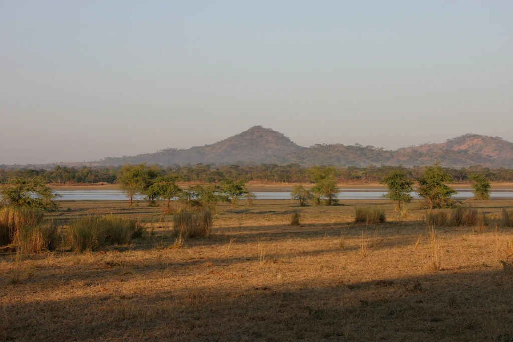
A wide, golden-hour view of Lake Kazuni, showing a calm body of water flanked by sparse trees and dry grasses, with rolling hills in the background.
A view of Lake Kazuni within Vwaza Marsh Wildlife Reserve.

Vwaza Marsh Wildlife Reserve history and protected-area timeline

Vwaza Marsh was established as a national game reserve within the protected-area system of Malawi, reflecting the country's broader effort to safeguard representative examples of its varied ecosystems, from montane grasslands on the Nyika Plateau to low-lying floodplains in the north. Its designation as an IUCN Category IV area underlines its primary purpose of managing habitats and species rather than being set aside purely as a wilderness reserve.

Over time, the reserve has acquired a quiet reputation for the seasonal movement of animals across the international border with Zambia, particularly with North Luangwa National Park. This cross-border dynamic has been important for sustaining populations of large mammals such as elephants and buffalo, and has shaped conservation thinking about the area as part of a larger ecosystem rather than an isolated unit.

In more recent years, Vwaza has also been in the public eye through individual wildlife stories. Notably, an orphaned elephant known as Moses was rescued by rangers from the South Rukuru River within the reserve and later moved to the Jumbo Foundation elephant orphanage in Lilongwe, drawing attention to both the challenges facing elephants in the region and the role of the reserve's rangers in frontline wildlife protection.

Vwaza Marsh Wildlife Reserve landscape and geographic character

The landscape of Vwaza Marsh is defined by its generally flat, low-lying topography, an unusual setting for a major Malawian reserve given the country's many dramatic highlands. The eastern edge of the reserve rises into hillier terrain, but the core of Vwaza consists of broad floodplains and gently undulating ground that drains toward the South Rukuru River.

Wetlands are the dominant visual and ecological feature. Seasonal marshes, flood channels and open water bodies, including Lake Kazuni, break up expanses of mopane and miombo woodland. In the wetter months these floodplains expand, attracting waterbirds and concentrating game along the higher ground, while in drier periods the landscape tightens around permanent water sources. The result is a setting that changes substantially through the year, with the wetlands acting as both a buffer and a focal point for wildlife activity.

Surrounding the wetland core, classic African savanna-woodland vegetation defines much of the terrain. Mature miombo canopies, characterized by broad-leaved deciduous trees, contrast with the more open, often bleached mopane woodland on heavier soils. Together, these vegetation types create a varied backdrop of light and shade that shapes the reserve's scenery and the experience of moving through it.

Vwaza Marsh Wildlife Reserve ecosystems, habitats, and plant life

Vwaza Marsh Wildlife Reserve protects a notable mosaic of wetland and woodland ecosystems that together support a wide range of plant and animal life. The reserve's vegetation includes extensive stands of mopane woodland, broad miombo savanna, and patches of denser woody cover edging the river systems and floodplains, interwoven with marshy areas that swell and recede with the seasons. Botanical surveys have documented 398 vascular plant species across 71 families, underlining the botanical richness embedded in this landscape.

Wetland habitats are particularly important for the reserve's ecological identity. Lake Kazuni and the surrounding marshes provide permanent water in a predominantly seasonal landscape, sustaining a characteristic range of aquatic and waterside species. The combination of permanent and seasonal wetlands with surrounding woodland creates a layered habitat structure that supports species dependent on water, edge, and open woodland alike.

Ecologically, Vwaza functions as part of a transboundary system. Its connection with Zambia's North Luangwa National Park means that herbivore and predator populations are not confined to its borders, and this interchange helps maintain the genetic and demographic health of the wider region's wildlife. The reserve's position between the Nyika Plateau and the South Rukuru floodplains also gives it a role in representing lowland northern habitats within Malawi's broader protected-area network.

Vwaza Marsh Wildlife Reserve wildlife and species highlights

Vwaza Marsh supports a rich and varied mammal community, with notable populations of large herbivores that shift through the landscape with the seasons. Large herds of Cape buffalo and African elephants are among its signature species, often moving between Vwaza and the North Luangwa National Park in Zambia. The reserve's antelope diversity is also striking, featuring roan antelope, greater kudu, Lichtenstein's hartebeest, common eland and impala, alongside common warthog in the more open woodland and grassland edge habitats.

Lake Kazuni anchors a notable hippopotamus presence in the reserve, with multiple pods congregating in and around its waters. These hippo concentrations are a defining wildlife feature of Vwaza and one of the main draws for visitors interested in river and lake ecosystems. Camera-trap surveys have also confirmed the presence of lions, leopards and wild dogs, although these predators are generally thought to move through the reserve rather than maintaining permanent resident populations.

Birdlife is one of Vwaza's strongest draws. The mix of seasonal floodplains, permanent wetlands and surrounding woodland supports an impressive waterbird community, with Goliath herons and openbill storks among the more conspicuous species around Lake Kazuni. The rare white-winged starling is also recorded in the reserve, adding ornithological significance. Together, these mammal and bird communities make Vwaza an important, if quieter, wildlife destination within Malawi.

Vwaza Marsh Wildlife Reserve conservation status and protection priorities

Vwaza Marsh holds meaningful conservation value as one of the largest lowland protected areas in northern Malawi and as part of the transboundary ecosystem shared with Zambia's North Luangwa National Park. Its IUCN Category IV status reflects a deliberate focus on managing habitats and species, and the reserve's combination of miombo, mopane, and wetland habitats represents a distinctive ecological profile within the country.

Protection of the reserve's wetland systems, particularly around Lake Kazuni and the broader South Rukuru floodplain, is central to its importance. These wetlands support hippopotamus populations, a rich bird community, and the seasonal concentration of herbivores, while also contributing to larger hydrological and ecological processes in northern Malawi. The reserve's nearly 400 recorded vascular plant species across 71 families underline its botanical significance.

The reserve's conservation role is further strengthened by its cross-border dynamics. Because animals regularly cross between Vwaza and North Luangwa, effective conservation requires thinking of the area as part of a single, larger landscape rather than an isolated unit. This transboundary context increases the stakes of protection and makes Vwaza a key component of regional efforts to maintain viable populations of elephants, buffalo and other wide-ranging species in central-southern Africa.

Vwaza Marsh Wildlife Reserve cultural meaning and human context

Vwaza Marsh lies in northern Malawi within the wider cultural landscape of the region bordered by Zambia and the Nyika Plateau. Its setting, between plateau highlands and floodplain lowlands, has historically supported communities whose livelihoods and movements are intertwined with seasonal flooding, river resources, and the wildlife that concentrates around permanent water sources. The reserve's marsh environments, in particular, have long been part of the rhythms of life for surrounding rural communities, even as access to the reserve itself has been shaped by traditional land-use patterns and modern conservation boundaries.

In more recent decades, the reserve has also become a setting for individual stories that capture wider conservation and humanitarian themes. The well-known case of Moses, an orphaned elephant rescued by Vwaza rangers from the South Rukuru River and later relocated to the Jumbo Foundation elephant orphanage in Lilongwe, has drawn public attention to the reserve and to the challenges facing elephants and the people who protect them across northern Malawi.

Top sights and standout views in Vwaza Marsh Wildlife Reserve

Among Vwaza Marsh Wildlife Reserve's standout features is its 1,000 square kilometer expanse of low-lying wetland and woodland, unusual within Malawi's highland-dominated protected-area system. Lake Kazuni is a centerpiece of the reserve, supporting substantial hippopotamus pods and a strong seasonal waterbird presence that includes Goliath herons, openbill storks and the rare white-winged starling.

A further highlight is the reserve's transboundary character. Regular movement of elephants, buffalo and other large mammals between Vwaza and Zambia's North Luangwa National Park makes it a living part of a broader central African ecosystem. Combined with its mosaic of mopane and miombo woodland, rich botanical record of nearly 400 vascular plant species, and quiet, lightly visited atmosphere, Vwaza offers a distinctive and ecologically significant experience within Malawi's network of protected areas.

Best time to visit Vwaza Marsh Wildlife Reserve

The character of a visit to Vwaza Marsh shifts meaningfully with the seasons, and understanding the wet and dry cycles is central to planning any trip. During the wetter months, the reserve's floodplains and marshes expand, transforming the landscape and attracting the greatest concentrations of waterbirds, while also making some roads and tracks harder to negotiate. This period tends to be quieter and more atmospheric, but access can be challenging.

In the drier months, the landscape contracts around permanent water sources such as Lake Kazuni, where hippopotamus pods and large mammal herds are easier to observe as they concentrate near reliable water. Visibility through the miombo and mopane woodland tends to improve at this time of year, and conditions for travel are generally better, though access remains more difficult than in many of Malawi's other major parks. Wildlife enthusiasts often favor the dry-season window for its combination of easier movement and reliable sightings around water.

Monthly climate preview

Examine long-term representative temperature ranges and monthly precipitation data across the reserve coordinate

Vwaza Marsh Wildlife Reserve Climate Normals and Annual Weather Patterns

Representative coordinate records show measured annual temperature fluctuations and monthly precipitation variations from 1991 to 2020 at Vwaza Marsh Wildlife Reserve. Reviewing the complete twelve-month statistical profile provides detailed long-term averages for sustained regional climate research.
Annual mean19 °C
15 °C23 °C
Jan21°
Feb21°
Mar20°
Apr19°
May17°
Jun15°
Jul15°
Aug17°
Sep20°
Oct23°
Nov23°
Dec22°
Warmest month
November

23.5 °C

Coolest month
July

15 °C

Wettest month
January

8.7 mm/day

Driest month
September

0.1 mm/day

Park location guide

Geography guide, regional context, and park location map for Vwaza Marsh Wildlife Reserve

Vwaza Marsh Wildlife Reserve park geography, regions, and map view in Malawi

Understand where Vwaza Marsh Wildlife Reserve sits in Malawi through a broader geographic reading of the surrounding landscape, nearby location context, and its mapped position within the national park landscape.

How Vwaza Marsh Wildlife Reserve fits into Malawi

Malawi is a landlocked country in Southeastern Africa. Formerly known as Nyasaland under British colonial rule, it gained independence in 1964 and became a multi-party democracy in 1994. The country is known for Lake Malawi, which comprises about one-fifth of its territory, and is governed as a unitary presidential republic with Lilongwe as its capital.

Wider geography shaping Vwaza Marsh Wildlife Reserve in Malawi

Malawi is located in Southeastern Africa within the Great Rift Valley. It is bordered by Zambia to the west, Tanzania to the north and northeast, and Mozambique to the east, south, and southwest. The country features highlands and plateaus in the northern and central areas, with the Great Rift Valley system running through the territory.

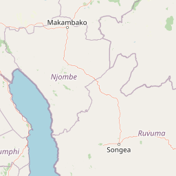
Map view of Vwaza Marsh Wildlife Reserve

Use this park location map to pinpoint Vwaza Marsh Wildlife Reserve in Malawi, understand its exact geographic position, and read its mapped placement within the surrounding landscape more clearly.

Pigeon | © OpenStreetMap contributors

Visual reference collection for floodplain wetlands and woodland habitats

Vwaza Marsh Wildlife Reserve Landscape and Scenery Photography

Photographic documentation reveals the distinct low-lying topography, seasonal marshlands, and wooded savanna of Vwaza Marsh Wildlife Reserve. Visual records provide essential context for understanding the protected area environment, wetland ecology, and remote wilderness character.

A wide, golden-hour view of Lake Kazuni, showing a calm body of water flanked by sparse trees and dry grasses, with rolling hills in the background.

Park atlas

Compare nearby national parks, regional wetlands, and connected transboundary reserves.

Parks Near Vwaza Marsh Wildlife Reserve and Surrounding Protected Areas

Browsing other parks near Vwaza Marsh Wildlife Reserve reveals how low-lying floodplains and woodland savannas connect to wider regional wildlife corridors. Examining adjacent protected landscapes provides valuable context for comparing lowland habitats with neighboring highland terrain.
National parkMalawi
About 12 km away#1 closest

North

Nyika National Park: Malawi National Park Atlas Exploration and Protected Landscape

Discover geographic context and mapped boundaries of this protected area.

Nyika National Park serves as a core entry for understanding Malawi's protected areas and natural landscapes through an atlas lens. Explore the park's designation as a national park, its geographic positioning within Malawi, and the mapped context that defines its protected status. This detail page provides a foundational view for appreciating the park's landscape and its contribution to the regional protected lands overview.

Area
3,134 km²
Established
1966
IUCN
II
Relief
Highland
National parkZambia
About 44 km away#2 closest

North

Nyika National Park: A Zambian National Park for Mapped Landscape Discovery

Explore its protected area boundaries and regional geographic context.

Nyika National Park in Zambia is a critical protected landscape offering valuable insights for geographic exploration. As a national park, its mapped terrain and regional context provide a distinct point of study within the country's atlas. Users can investigate the park's specific geographic features and its contribution to Zambia's conservation landscapes, enriching their understanding of protected areas.

Relief
Highland
Climate
Subtropical
Access
Moderate access
Scope
Terrestrial
Watercolor painting of a tranquil scene featuring soft-hued trees, rolling hills, and a water's edge, characterized by a light and airy artistic style.
Wildlife reserveNorthern Region
About 85 km away#3 closest

South

Chikangawa Forest Reserve: Mapping Malawi's Viphya Mountains Protected Wildlife Landscape

Explore montane forest ecosystems and exotic pine plantations

Chikangawa Forest Reserve stands as a major protected block within Malawi's Northern Region. The area covers extensive mountain ridges where native montane vegetation interweaves with significant man-made pine plantations. This geographic atlas entry provides insight into the reserve's role as a watershed protector and its unique position across the Viphya Plateau.

Area
1,147.8 km²
Established
1948
Relief
Mountain
Climate
Tropical
Watercolor illustration showing a soft-focus landscape with scattered trees, low scrub, and distant rolling hills in pale green and yellow tones.
Wildlife reserveMalawi
About 109 km away#4 closest

South

Nkhotakota Wildlife Reserve: Protected Geography and Rift Valley Landscapes

A vast, recovering miombo woodland sanctuary in central Malawi.

Nkhotakota Wildlife Reserve represents a massive conservation effort within the Great Rift Valley, protecting 1,800 square kilometres of steep ridges, riverine gorges, and dense woodland patches. This atlas entry details the reserve's unique topography, ranging from high-altitude escarpments down toward Lake Malawi, and its role as a pivotal site for large mammal restoration and bird diversity in Southeastern Africa.

Area
1,800 km²
IUCN
IV
Relief
Mixed relief
Climate
Tropical
National parkMuchinga Province
About 146 km away#5 closest

Southwest

North Luangwa National Park: National Park Protected Landscape and Regional Geography

Mapped boundaries and geographic context within Muchinga Province.

North Luangwa National Park is a designated national park offering critical insights into Zambia's protected landscapes. This page provides an atlas-driven view of its geographic scope, emphasizing its mapped boundaries and its position within Muchinga Province. Explore the fundamental geography and protected area context that defines North Luangwa National Park for structured landscape discovery.

Area
4,636 km²
Established
1972
IUCN
II
Relief
Mixed relief
National parkZambia
About 195 km away#6 closest

Southwest

Lukusuzi National Park: Zambia's Protected National Park Geographic Context

Mapped protected area and regional landscape identity for Lukusuzi.

Gain detailed insights into Lukusuzi National Park, a key protected area in Zambia, through its geographic setting and mapped boundaries. This page provides essential context for understanding the park's landscape character and its significance within the national park atlas. Explore the fundamental protected-area geography of this distinct Zambian natural landscape.

IUCN
II
Access
Access unknown
Scope
Terrestrial
National parkNjombe Region
About 217 km away#7 closest

North

Kitulo National Park: National Park within Njombe Region's Geographic Atlas

Mapped protected area boundaries and regional landscape context.

Kitulo National Park represents a distinct national park within the geographic atlas of Tanzania's Njombe Region. This page offers a focused exploration of its protected landscape identity, highlighting its mapped boundaries and contributing to a broader understanding of regional geography. It is designed for users seeking detailed, atlas-centric information about Kitulo National Park's specific natural landscape and its position within the surrounding terrain.

Area
413 km²
Established
2005
IUCN
II
Visitors
409 annual
National parkZambia
About 222 km away#8 closest

Southwest

Luambe National Park: Detailed Geographic and Protected Area Atlas Information

Mapped landscape context within Zambia's natural regions.

This section provides an in-depth look at Luambe National Park, detailing its role as a protected area within the diverse geography of Zambia. Users can explore its mapped boundaries and understand its significance within the country's atlas of natural landscapes. The focus is on providing a concrete geographic perspective, essential for understanding how this national park fits into the regional conservation and landscape context of southern Africa.

Area
300 km²
IUCN
II
Relief
Upland
Climate
Tropical

Common questions about visiting, size, designation, and location context for Vwaza Marsh Wildlife Reserve

Vwaza Marsh Wildlife Reserve FAQs for park facts, access, geography, and protected area context

Find quick answers about Vwaza Marsh Wildlife Reserve, including protected-area facts, park geography, trail and visitor context, and how the park fits into its surrounding country and regional landscape.
MoriAtlas Explorer

Continue Your Protected Areas Search Across the Global Atlas

Deepen your exploration by continuing the structured search for national parks and protected areas worldwide. Utilize the comprehensive filtering capabilities to compare different conservation landscapes and refine your understanding of global park geography. Discover more about the distribution and characteristics of protected natural areas.

Global natural geography