Mori Atlas logo
Nature reserveSpitzerberg

Analyzing the arid rock steppes and Pannonian dry habitats of this regional conservation area.

Spitzerberg Nature Reserve and the Protected Limestone Landscapes of Lower Austria

Spitzerberg represents one of the most prominent nature reserves in Lower Austria, serving as the southern terminus of the Hundsheimer Berge range. This protected landscape is defined by steep limestone and dolomite slopes that create a mosaic of rock steppes and dry forest habitats. Its Pannonian steppe character offers a distinct ecological contrast to the surrounding Alpine terrain, providing vital conservation space for specialized arid-terrain flora and fauna.

nature reserveLower AustriaHundsheimer BergePannonian steppedry grasslandrock steppe

Spitzerberg

Nature reserve

Park overview

Structured park overview, official facts, and landscape profile for Spitzerberg Nature Reserve

Spitzerberg Nature Reserve park facts, protected area profile, and essential visitor context

Review the core facts for Spitzerberg Nature Reserve, including designation, size, terrain, visitor scale, habitats, and operating context in one park-focused overview.

About Spitzerberg Nature Reserve

Spitzerberg Nature Reserve protects a focused block of dry, calcareous habitat in the eastern foothills of the Alps, near the Hungarian border. The site is small in absolute terms but ecologically distinctive, occupying a position where Alpine geology meets the climatic influence of the Pannonian Basin. This geographic setting produces one of the most important concentrations of dry grassland and steppe habitat in Austria.

The reserve sits on the Spitzerberg hill, the southern extension of the Hundsheimer Berge range, and consists largely of steep slopes formed from limestone and dolomite. Because these rocks weather slowly and support only a thin layer of humus, the soils remain shallow and dry, supporting vegetation adapted to arid conditions. Rock steppes, dry and semi-dry grasslands, and dry forest communities dominate the landscape, each shaped by exposure, slope angle, and bedrock chemistry.

Established as a nature reserve in 1981 and recognized as part of the Natura 2000 network, Spitzerberg reflects a long-standing interest in conserving Pannonian dry habitats in Lower Austria. Between 2004 and 2008 the area was included in the LIFE-Nature project Pannonische Steppen- und Trockenrasen, an internationally supported initiative focused on preserving the characteristic steppe and dry grassland landscapes of the region. Today the reserve remains an important reference site for researchers studying dryland ecosystems, calcareous flora, and the wildlife communities that depend on open, sun-exposed terrain.

Quick facts and research context for Spitzerberg Nature Reserve

Spitzerberg Nature Reserve is located in Prellenkirchen in Lower Austria and protects the southern slopes of the Hundsheimer Berge mountain range. The site has been legally protected since 1981 and carries IUCN Category IV designation as a habitat and species management area.

The reserve covers approximately 226 hectares of limestone and dolomite hill country, dominated by rock steppes, dry grasslands, and dry forests. It forms part of the wider Natura 2000 area Hundsheimer Berge and was included in the LIFE-Nature project Pannonische Steppen- und Trockenrasen from 2004 to 2008.

Protection and recognition

Terrestrial protected area framework and formal designation records

Spitzerberg Protection Status and Documented Conservation Scope

Spitzerberg maintains a defined terrestrial protection scope within its documented geographical boundaries. Conservation records outline the administrative framework and official designation history associated with the protected landscape.

Protection details

Protection scope
Terrestrial
Park context

Deeper park guide and search-rich context for Spitzerberg Nature Reserve

Spitzerberg Nature Reserve history, landscape, wildlife, and travel context

Explore Spitzerberg Nature Reserve through its history, landscape character, ecosystems, wildlife, conservation priorities, cultural context, and seasonal travel timing in a structured park guide built for atlas discovery and search intent.

Why Spitzerberg Nature Reserve stands out

Spitzerberg is best known for its Pannonian-influenced dry habitats, particularly the rock steppes and dry grasslands that thrive on its steep limestone and dolomite slopes. The combination of calcareous bedrock, thin soils, and a warm, dry regional climate produces vegetation communities more typical of the Hungarian Basin than of the nearby Alps. The reserve is also recognized for its restricted plant life, including Artemisia pancicii, and for its specialized fauna adapted to open, arid terrain, such as the European ground squirrel and the clouded Apollo butterfly.
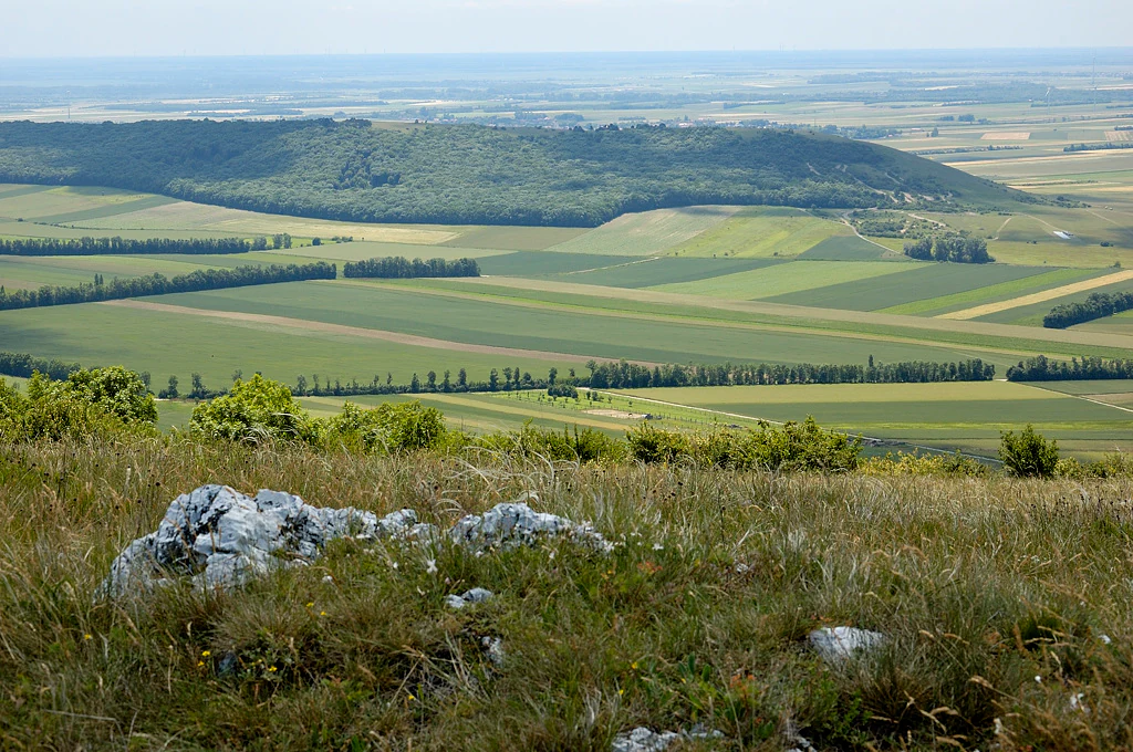
A high vantage point looking down onto a patchwork of green and yellow agricultural fields, with a forested ridge in the background and rocky, grassy terrain in the immediate foreground.
A wide view overlooking the surrounding plains and fields from the Spitzerberg nature reserve.

Spitzerberg Nature Reserve history and protected-area timeline

The Spitzerberg area gained formal protection in 1981, when it was designated a nature reserve under Lower Austrian conservation law. This designation reflects growing recognition of the ecological value of Pannonian dry habitats, which had become increasingly rare across the broader central European landscape due to changing land use.

In the following decades, the reserve became part of the Natura 2000 network through the Hundsheimer Berge site, aligning its national protection with European Union habitat and species conservation frameworks. From 2004 to 2008, the area was included in the LIFE-Nature project Pannonische Steppen- und Trockenrasen, which focused on the preservation and management of steppe and dry grassland habitats across the Pannonian region. The project brought additional resources and conservation attention to Spitzerberg and reinforced its role within the wider regional conservation network.

Spitzerberg Nature Reserve landscape and geographic character

The Spitzerberg rises as a compact, steep-sided hill forming the southernmost extension of the Hundsheimer Berge range. Its slopes are built from limestone and dolomite, rocks that weather slowly and support only a thin, patchy humus layer. As a result, soil depth is limited and water retention is low, producing conditions that are exceptionally dry for a site in Austria.

The terrain is characterized by varied exposure and slope angles, which create a mosaic of microhabitats across the hill. Open rock outcrops, shallow soils, and partially vegetated slopes give way to denser dry forest in more sheltered places. This combination of rocky and vegetated surfaces under a relatively warm, dry regional climate defines the visual and ecological character of the reserve.

Spitzerberg Nature Reserve ecosystems, habitats, and plant life

The nature reserve is dominated by vegetation adapted to arid, calcareous conditions. Rock steppes cover many of the steepest, most exposed slopes, while dry and semi-dry grasslands occupy areas where shallow soils allow herbaceous species to persist. In more sheltered sections, dry forest communities develop, forming a structural contrast to the open steppe and grassland habitats.

These habitat types belong to the broader Pannonian dry grassland and steppe complex, a vegetation group otherwise more typical of the Hungarian Basin than of Alpine Austria. The intersection of these influences gives Spitzerberg its distinctive ecological signature, with warm, dry-loving plant communities set against a backdrop of limestone geology. The presence of species such as Artemisia pancicii underlines the site's role as a refugium for steppe-affiliated flora within the Austrian protected-area network.

Spitzerberg Nature Reserve wildlife and species highlights

Wildlife in the Spitzerberg Nature Reserve reflects the open, dry, sun-exposed character of the landscape. The European ground squirrel is among the most notable mammal species recorded, typically associated with short-grass steppe and dry grassland environments. Its presence within the reserve reflects the habitat's affinity with Pannonian lowland conditions.

Butterflies are also a significant component of the reserve's fauna. The clouded Apollo, a striking species associated with dry, rocky habitats and open meadows, occurs within the protected area. The combination of warm microclimates, varied slope exposures, and abundant nectar sources supports a diverse insect community, which in turn sustains the broader food web of the reserve.

Spitzerberg Nature Reserve conservation status and protection priorities

Spitzerberg Nature Reserve plays a focused but important role in conserving Pannonian dry habitats within Austria. As one of the largest nature reserves in Lower Austria, it protects a substantial area of rock steppe, dry grassland, and dry forest on calcareous bedrock, habitat types that are highly vulnerable to changes in land use, grazing pressure, and vegetation succession.

The reserve's inclusion in the Natura 2000 network through the Hundsheimer Berge site underscores its European significance, connecting it to broader efforts to preserve representative dryland ecosystems across the continent. Participation in the LIFE-Nature project Pannonische Steppen- und Trockenrasen between 2004 and 2008 brought targeted conservation management to the area, supporting habitat restoration and the maintenance of open steppe conditions. Together, these frameworks position Spitzerberg as a key reference site for the conservation of Pannonian dry habitats in the Austrian protected-area system.

Top sights and standout views in Spitzerberg Nature Reserve

Spitzerberg stands out among Austrian reserves for the concentration of Pannonian dry habitats it protects on a relatively small area of limestone and dolomite hill. Rock steppes, dry grasslands, and dry forests combine here in a landscape shaped by steep slopes, thin soils, and a warm regional climate.

The reserve is also notable for its rare plant and animal species, including Artemisia pancicii, the European ground squirrel, and the clouded Apollo butterfly. Its long-standing protection status, Natura 2000 integration, and inclusion in the LIFE-Nature project Pannonische Steppen- und Trockenrasen reinforce its significance for both national and European dryland conservation.

Best time to visit Spitzerberg Nature Reserve

Spring and early summer are generally the most rewarding times to experience Spitzerberg, when wildflowers are in bloom across the dry grasslands and steppe habitats and the weather is most suitable for exploring the steep, exposed terrain. These months also tend to bring higher insect activity, increasing the chances of observing butterflies such as the clouded Apollo.

Late summer and early autumn can also offer pleasant conditions, with warm, dry weather typical of the Pannonian climate influence. Winter visits are possible but should account for the steep and rocky terrain, which may be slippery under cold or wet conditions.
Monthly climate preview

Month by month long term averages recorded at representative coordinates

Spitzerberg Climate Normals: Annual Temperature and Precipitation Patterns

Spitzerberg exhibits a measured annual cycle of shifting temperatures and precipitation totals based on NASA data from 1991 to 2020. Reviewing the complete twelve month climate profile reveals deeper baseline patterns across the protected landscape.
Annual mean11 °C
-1 °C22 °C
Jan-1°
Feb
Mar
Apr11°
May16°
Jun20°
Jul22°
Aug22°
Sep16°
Oct10°
Nov
Dec
Warmest month
July

22.4 °C

Coolest month
January

-1.4 °C

Wettest month
June

2.4 mm/day

Driest month
February

1.1 mm/day

Park location guide

Geography guide, regional context, and park location map for Spitzerberg Nature Reserve

Spitzerberg Nature Reserve park geography, regions, and map view in Austria

Understand where Spitzerberg Nature Reserve sits in Austria through a broader geographic reading of the surrounding landscape, nearby location context, and its mapped position within the national park landscape.

How Spitzerberg Nature Reserve fits into Austria

Austria is a landlocked country in Central Europe, bordered by Germany, Czech Republic, Slovakia, Hungary, Slovenia, Italy, Switzerland, and Liechtenstein. The country is a federal semi-presessional republic composed of nine states, with Vienna as its capital and largest city. It has a population of approximately 9.1 million people.

Wider geography shaping Spitzerberg Nature Reserve in Austria

Austria is located in Central Europe, lying in the Eastern Alps. It is bordered by Germany and Czech Republic to the north, Slovakia to the northeast, Hungary to the east, Slovenia and Italy to the south, and Switzerland and Liechtenstein to the west.

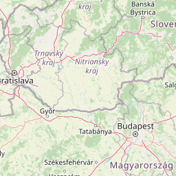
Map view of Spitzerberg Nature Reserve

Use this park location map to pinpoint Spitzerberg Nature Reserve in Austria, understand its exact geographic position, and read its mapped placement within the surrounding landscape more clearly.

Pigeon | © OpenStreetMap contributors

Location context for Spitzerberg Nature Reserve

Lower Austria

Explore mapped terrain, limestone slopes, and protected dry habitats across eastern Austria

Spitzerberg Photos and Landscape Scenery: Visualizing the Pannonian Reserve

Visual records reveal the steep limestone terrain, rock steppes, and dry grasslands that define the Pannonian character of Spitzerberg. Studying field photography helps researchers interpret the microhabitats and conservation value preserved within the Hundsheimer Berge range.

A high vantage point looking down onto a patchwork of green and yellow agricultural fields, with a forested ridge in the background and rocky, grassy terrain in the immediate foreground.

Park atlas

Compare regional protected areas and connected Pannonian dry habitats

Other Parks Near Spitzerberg and Surrounding Protected Landscapes

Continue exploring regional protected areas and nearby national parks that share the distinctive Pannonian climate and calcareous terrain of Spitzerberg. Comparing adjacent conservation zones reveals broader ecological patterns across the limestone hills and dry grasslands of eastern Austria.
Watercolor painting of a rolling hilly landscape with green slopes, sparse trees, and a winding path in the foreground.
Nature reserveLower Austria
Mapped park locations coincide#1 closest

Hundsheimer Berg Nature Reserve: Protected Landscapes of the Lower Austrian Carpathians

Mapped dry steppe, karst topography, and pannonian forest habitats

Rising abruptly from the Danube lowlands, Hundsheimer Berg preserves a compact range of crystalline and limestone hills. This nature reserve provides vital insights into the pannonian biogeographic region, featuring a diverse mosaic of rocky slopes and dry grasslands that support a high concentration of rare insects and plants.

Area
1.66 km²
Established
1965
IUCN
IV
Relief
Mountain
National parkLower Austria
About 2.4 km away#2 closest

Northwest

Danube-Auen National Park: Protected Floodplain Ecosystem and Regional Geography

Mapped boundaries and vital riparian landscape in Lower Austria.

Delve into the unique protected landscape of Danube-Auen National Park, a cornerstone of Central European riparian conservation. This page offers detailed insights into its mapped boundaries, the dynamic interplay of river channels, lowland forests, and wetlands, and its significant role within the geographic context of Lower Austria. Understand the atlas value of this protected area, ideal for discovering rich natural terrain and ecosystem context.

Area
93 km²
Established
1996
IUCN
II
Relief
Lowland
Watercolor painting showing a landscape with rolling terrain, water features, and distant mountains
National parkBurgenland
About 23 km away#3 closest

South

Neusiedler See-Seewinkel National Park: Protected Steppe Lake Landscape in Burgenland

Explore mapped wetland geography and birdwatching significance.

Neusiedler See-Seewinkel National Park showcases a rare steppe lake environment and extensive wetland habitats at the eastern edge of Austria, within the Burgenland region. This protected area is globally recognized for its exceptional avian diversity and the unique ecological mosaic formed by reed beds, salt marshes, and seasonal pools. Explore its mapped boundaries and distinctive Pannonian geography for a deep understanding of this vital European protected landscape.

Area
97 km²
Established
1993
IUCN
II
Relief
Lowland
A horizontal watercolor illustration depicting a quiet riverbank with soft green trees, light vegetation, and calm water reflecting the landscape.
Nature reserveVienna
About 32 km away#4 closest

West

Lobau Nature Reserve: Mapping the Protected Danube Floodplain Landscapes of Vienna

Riparian forests, oxbow lakes, and historic wetland ecosystems.

Lobau preserves the ecological memory of the Danube through a landscape of slow-moving water bodies and dense forest stands. Situated within Vienna, this protected area features a distinct topography of dry gravel terraces, reedy ponds, and riparian corridors, offering significant insights into the region's natural history and riverine geography.

Area
22 km²
Established
1905
Relief
Lowland
Climate
Temperate
Watercolor painting of a shallow lake scene with green reeds in the foreground, small trees on the shoreline, and rolling hills in the soft, hazy background.
Nature reserveAustria
About 35 km away#5 closest

Southwest

Lake Neusiedl: Protected Nature Reserve and Pannonian Steppe Geography in Austria

An endorheic lake system and critical wetland sanctuary.

Lake Neusiedl is a distinct nature reserve representing a rare European steppe lake environment. Its geography includes a vast ring of Phragmites reed beds, saline wetlands, and surrounding lowlands that form a vital migratory corridor. The lake serves as a cornerstone for protected landscapes in Austria, blending natural marshland dynamics with a deeply storied cultural history.

Area
315 km²
Established
1993
Relief
Lowland
Climate
Temperate
Watercolor illustration of a landscape with green hills, a body of water, and trees under a soft sky
National parkGyőr-Moson-Sopron
About 46 km away#6 closest

South

Fertő-Hanság National Park: Central European Wetland and Salt Lake Protected Area

Mapped Geographic Boundaries and Landscape Context

Fertő-Hanság National Park, situated in Győr-Moson-Sopron, Hungary, is a vital protected landscape renowned for its shallow salt lake and expansive marshlands. This page provides an atlas-focused discovery of its protected area, highlighting the unique interplay of reed beds and alkaline grasslands. Understand the park's geographic setting and its role as a significant wetland ecosystem for bird populations and specialized flora.

Area
235.88 km²
Established
1991
IUCN
II
Relief
Lowland
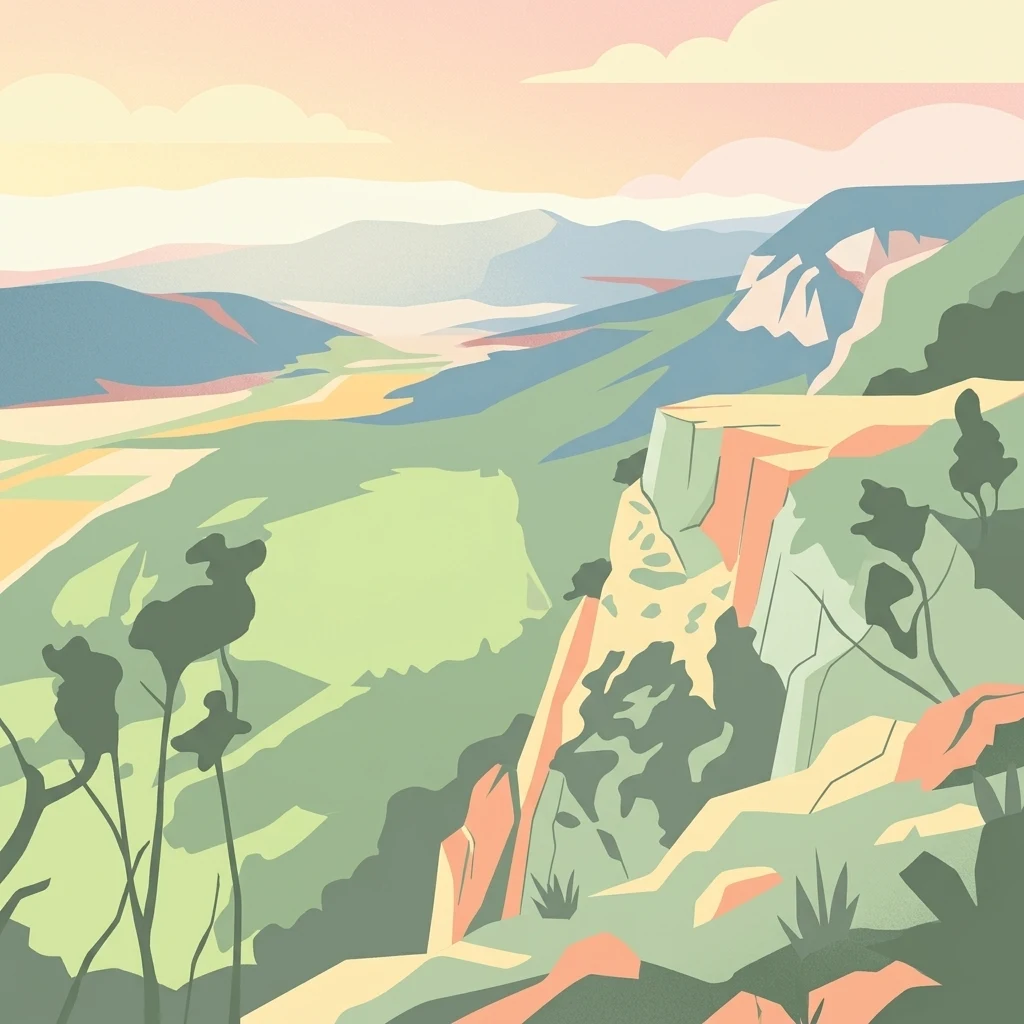
A stylized digital illustration of a mountainous landscape at sunset, featuring prominent steep limestone cliffs in the foreground and a vast valley extending into the distance under a warm-toned sky.
Nature reserveLower Austria
About 74 km away#7 closest

Southwest

Hohe Wand Nature Park: Mapped Geography and Protected Landscapes in Lower Austria

A limestone plateau mountain at the Alpine-Pannonian transition

Located in Lower Austria, Hohe Wand Nature Park encompasses a distinct limestone plateau and dramatic southeastern cliffs. Its protected status reflects the convergence of Alpine and Pannonian geography, offering a unique opportunity to study karst geology, exposed cliff habitats, and the transition zone between high mountain ranges and the Vienna Basin lowlands.

Relief
Mountain
Climate
Temperate
Access
Easy access
Scope
Terrestrial
Protected landscapeLower Austria
About 76 km away#8 closest

West

Vienna Woods: Protected Landscape, Forested Highlands, and Alpine Foothill Geography

Natural terrain and protected boundaries in Lower Austria

The Vienna Woods encompass a distinct geographic region where sandstone ridges meet limestone formations. This protected landscape provides a dense network of forest habitats, river gorges, and significant peaks overlooking the Danube. Its structure traces the edge of the Alps, offering a rich study in regional geology, elevation gradients, and the intersection of natural wilderness with the surrounding basin environment.

Area
1,056.45 km²
Established
1987
Relief
Mountain
Climate
Temperate

Common questions about visiting, size, designation, and location context for Spitzerberg Nature Reserve

Spitzerberg Nature Reserve FAQs for park facts, access, geography, and protected area context

Find quick answers about Spitzerberg Nature Reserve, including protected-area facts, park geography, trail and visitor context, and how the park fits into its surrounding country and regional landscape.
MoriAtlas Explorer

Continue Your Protected Areas Search Across the Global Atlas

Deepen your exploration by continuing the structured search for national parks and protected areas worldwide. Utilize the comprehensive filtering capabilities to compare different conservation landscapes and refine your understanding of global park geography. Discover more about the distribution and characteristics of protected natural areas.

Global natural geography