
Mori Atlas logo
National parkFertő-Hanság National Park

Discover the mapped boundaries and regional geography of this transboundary protected area.

Fertő-Hanság National Park: A Unique Salt Lake and Wetland Protected Landscape in Hungary

(Fertő–Hanság Nemzeti Park)

Fertő-Hanság National Park represents a critical protected landscape at the intersection of wetland habitats and alkaline grasslands in northwestern Hungary. Located within Győr-Moson-Sopron County, this national park is defined by the distinctive Lake Fertő, one of Eurasia's westernmost continental salt lakes, and the rehabilitated Hanság marshlands. Our platform offers a structured view of this protected area, detailing its geographic context and the ecological significance of its expansive reed beds and unique salt-tolerant vegetation, perfect for atlas-based exploration.

wetlandlaketransboundary parksalt lakebirdwatchingreed beds
Illustration of a lake with small islands, surrounded by grassy areas and trees, with mountains in the background

Fertő-Hanság National Park

National park

Park overview

Structured park overview, official facts, and landscape profile for Fertő-Hanság National Park

Fertő-Hanság National Park park facts, protected area profile, and essential visitor context

Review the core facts for Fertő-Hanság National Park, including designation, size, terrain, visitor scale, habitats, and operating context in one park-focused overview.

About Fertő-Hanság National Park

Fertő-Hanság National Park represents a remarkable example of Central European wetland conservation, protecting a landscape that straddles the Hungary-Austria border and encompasses one of the region's most ecologically distinctive lakes. Lake Fertő, known as Lake Neusiedl in German, is a shallow, saline steppe lake that has shaped human settlement and wildlife patterns in this border region for millennia. The lake's extreme shallowness—just one meter on average—combined with strong prevailing winds means its size and configuration can change substantially within hours, sometimes by as much as 50 to 80 centimeters. This dynamic character, along with the lake's high salt content of approximately 2 kilograms per cubic meter, creates conditions found nowhere else in western Eurasia. The park was established in 1991 originally as Fertő Lake National Park, then expanded in 1994 to include the adjacent Hanság marshland, giving the park its current name. The park's management works in close coordination with Austria's Neusiedler See-Seewinkel National Park, with both parks sharing a joint opening ceremony in 1994 and coordinated conservation efforts ever since. The international importance of this transboundary landscape is underscored by its designation as a UNESCO biosphere reserve in 1979 and its listing under the Ramsar Convention in 1989. Beyond its ecological significance, the park preserves elements of traditional Hungarian rural landscape, including the use of traditional livestock breeds such as Hungarian Grey cattle, Racka sheep, and water buffalo to maintain the open grasslands through controlled grazing.

Quick facts and research context for Fertő-Hanság National Park

Fertő-Hanság National Park lies in Győr-Moson-Sopron county in northwestern Hungary, adjacent to the Austrian border. The protected area covers approximately 236 km² within Hungary, with an additional 105 km² on the Austrian side forming the linked Neusiedler See-Seewinkel National Park. Lake Fertő is a shallow, wind-dominated saline lake with a surface area of around 310 km² that changes dramatically in size and shape due to its average depth of just one meter. The park comprises two main sections: the lake and surrounding wetlands to the west, and the eastern puszta grasslands. The park headquarters are located at Kócsagvár in Sarród.

Protection and recognition

Documenting the mixed protection scope and transboundary coordination across international borders

Fertő-Hanság National Park Protection Status and Transboundary Designation

Explorers can examine the official protection status and transboundary management framework that defines the conservation boundaries of Fertő-Hanság National Park. Map-based analysis highlights how the mixed protection scope supports ecological continuity across geopolitical borders to maintain regional conservation integrity.

Protection details

Protection scope
Mixed
Transboundary protection
Yes
Park context

Deeper park guide and search-rich context for Fertő-Hanság National Park

Fertő-Hanság National Park history, landscape, wildlife, and travel context

Explore Fertő-Hanság National Park through its history, landscape character, ecosystems, wildlife, conservation priorities, cultural context, and seasonal travel timing in a structured park guide built for atlas discovery and search intent.

Why Fertő-Hanság National Park stands out

Fertő-Hanság National Park is best known for its exceptional wetland bird populations, particularly large colonies of great egrets, common spoonbills, purple herons, and greylag geese that nest in the extensive reed beds surrounding Lake Fertő. The park is also renowned for its alkaline puszta grasslands in the eastern portions, which support rare steppe vegetation including the Hungarian iris and the yellow lady's slipper orchid. The lake's unique status as the westernmost continental salt lake in Eurasia makes it botanically significant, supporting specialized halophyte plant communities. The transboundary cooperation between Hungarian and Austrian park management creates one of Europe's most important cross-border conservation partnerships.
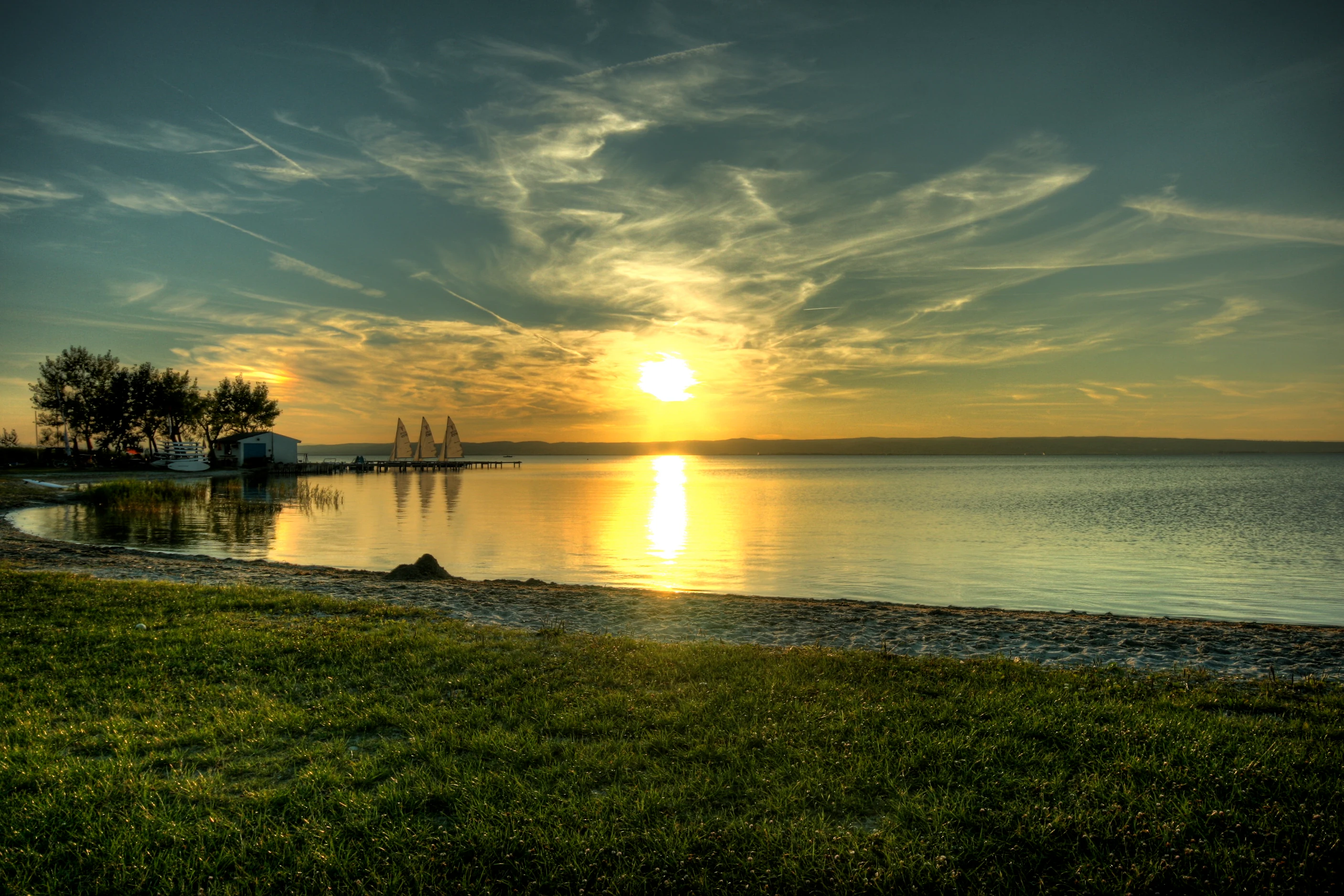
Sunset over a large lake with golden reflection on water, grassy shoreline in foreground, trees and small structure on left, clear sky with scattered clouds
Sunset reflection over Lake Fertő in Fertő-Hanság National Park

Fertő-Hanság National Park history and protected-area timeline

Fertő-Hanság National Park traces its institutional history to 1991 when it was established as Fertő Lake National Park, reorganized from the earlier Fertő Lake Landscape Protection District. The park received its current name in 1994 when the Hanság Landscape Protection District was incorporated into the protected area. The same year, on April 24, 1994, the park was officially opened in a joint ceremony with the newly established Austrian Neusiedler See-Seewinkel National Park, marking an important moment in transboundary conservation cooperation in Central Europe. Prior to the establishment of the national park, the region had been subject to significant hydrological modifications during the early decades of the 20th century, when both Lake Fertő and the connected Hanság marshland were subject to drainage and river regulation projects aimed at converting wetlands to agricultural land. These alterations fundamentally changed the hydrology of the region, accelerating the reed encroachment that had begun naturally and reducing the open water areas. Beginning in 2001, rehabilitation efforts commenced with the deliberate flooding of the Nyirkai-Hany area, representing a concerted attempt to restore some of the lost wetland functions. The park also incorporates several pre-existing protected areas, including landscape protection districts in the Sopron Mountains, Pannonhalma, and Szigetköz regions that were integrated into the park's management framework.

Fertő-Hanság National Park landscape and geographic character

The landscape of Fertő-Hanság National Park is defined by the interplay between Lake Fertő's shallow saline waters, extensive reed beds, and the open alkaline grasslands of the eastern puszta. Lake Fertő occupies a shallow depression approximately 20,000 years old, formed by crustal movements and glacial winds during the Würm glacial period. The lake's basin, oriented roughly north-south, is extremely flat, with average depths around one meter, making it highly susceptible to wind-driven water level fluctuations. The western and southern shores are dominated by extensive reed beds that have expanded significantly since the drainage projects of the early 20th century. In contrast, the eastern portions of the park consist of open, treeless puszta grasslands characterized by alkaline soils and specialized salt-tolerant vegetation. The Hanság area, situated behind the lake's eastern levee, comprises a complex of remaining lakes, marsh meadows, and rehabilitated wetlands that represent some of the last remaining examples of this once-extensive marshland system in the region. The landscape is remarkably flat throughout, with only subtle elevation changes marking the transition between different habitat types.
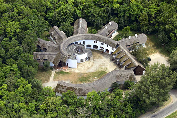
Aerial view of a circular building with multiple thatched roofs surrounded by dense green forest
Aerial view of a circular building with thatched roofs surrounded by dense forest in Fertő-Hanság National Park

Fertő-Hanság National Park ecosystems, habitats, and plant life

The ecological character of Fertő-Hanság National Park centers on its unique combination of saline lake, reed wetlands, and alkaline grassland habitats that together support exceptional biodiversity. Lake Fertő's saline waters—unusual for a lake at this latitude in western Eurasia—support specialized aquatic organisms adapted to elevated salt concentrations. The lake's extensive reed beds, dominated by common reed, create one of Central Europe's most important breeding and staging areas for waterbirds, with colonies of great egrets, common spoonbills, purple herons, and greylag geese among the most significant. The alkaline puszta grasslands of the eastern park section contain distinctive plant communities adapted to saline soils, including Puccinellia peisonis, Aster tripolium, and Suaeda maritima. The meadows west of the lake support rare orchid species such as the yellow lady's slipper, fly orchid, and spider orchid, as well as the Hungarian iris. The park's vegetation also includes significant butterfly diversity, with species such as the peacock butterfly, oak hawk moth, and death's-head hawkmoth recorded. The Hanság marshland, despite historical drainage impacts, retains important wetland habitats with remnant lakes supporting fish populations and serving as feeding grounds for waterbirds.

Fertő-Hanság National Park wildlife and species highlights

Fertő-Hanság National Park supports remarkably diverse wildlife populations, with particular significance attached to its bird communities. The lake and its reed beds provide crucial breeding habitat for colonial waterbirds including the great egret, common spoonbill, purple heron, and nyári lúd (summer goose). During migration seasons, the area hosts large numbers of waders from the Scolopacidae family, while rare species such as the red-breasted goose, white-tailed eagle, and hen harrier occur seasonally or as breeding species. The park's fish populations include weatherfish, northern pike, and the ziege, a fish species characteristic of Central European lowland lakes. The alkaline puszta areas are home to the critically endangered Rákosi vipera (Rákosi's viper), one of Europe's rarest snakes, while the reed beds support populations of water snakes. The Hanság marshes contain populations of the viviparous lizard, and the remaining lakes support the tench and the Lápi póc (Balkan loach). The park's invertebrate fauna includes diverse dragonfly species, butterflies, and the medicinal leech, reflecting the variety of wetland and grassland habitats present.

Fertő-Hanság National Park conservation status and protection priorities

Fertő-Hanság National Park represents one of Central Europe's most important conservation areas, with its dual international designations reflecting outstanding universal value. The park's listing as a UNESCO biosphere reserve since 1979 recognizes the successful integration of conservation with sustainable land use in this cultural landscape. Its designation as a Ramsar Convention Wetland of International Importance since 1989 acknowledges the area's global significance for waterbird conservation, particularly as a staging area for migratory species connecting breeding grounds in northern Europe with wintering areas in the Mediterranean and Africa. The transboundary cooperation between the Hungarian and Austrian park administrations creates a unified conservation approach across the international border, though this partnership has faced challenges in recent years regarding development pressures. Conservation challenges include the ongoing reed encroachment in the lake, the legacy effects of historical drainage, and the need to balance visitor access with habitat protection. The park's conservation programming includes habitat management through traditional grazing with heritage livestock breeds, waterbird monitoring, and public environmental education.

Fertő-Hanság National Park cultural meaning and human context

The cultural landscape of Fertő-Hanság reflects centuries of human interaction with this distinctive wetland and steppe environment. The region has historical connections to Hungarian aristocratic families, including the Széchenyi lineage, whose ancestors established the notable Nagycenk lime avenue in the 1750s, a protected landscape feature now within the park's territory. Traditional rural land use practices have shaped the puszta grasslands, where Hungarian Grey cattle, Racka sheep, and water buffalo continue to be maintained using traditional husbandry methods. These heritage breeds play an active role in conservation management, as their grazing helps maintain the open grassland habitats that support rare plant and invertebrate species. The park's cultural significance is also linked to the broader Fertő/Neusiedler See cultural landscape, recognized as a potential World Heritage candidate that embodies the interplay between human communities and this challenging saline wetland environment over generations.

Top sights and standout views in Fertő-Hanság National Park

Fertő-Hanság National Park stands out as a premier birdwatching destination in Central Europe, with the Lake Fertő reed colonies supporting some of the largest breeding populations of great egrets and common spoonbills on the continent. The transboundary protected area creates one of Europe's most significant cross-border conservation landscapes, with coordinated management between Hungary and Austria. The lake's unique character as the westernmost continental salt lake in Eurasia makes it a distinctive geological and ecological feature. The park preserves some of the last remaining alkaline puszta grasslands in the Carpathian Basin, with their specialized plant communities and associated butterfly fauna. The Hanság rehabilitation area demonstrates successful wetland restoration, providing a model for similar projects in the region. The park's dual Ramsar and biosphere reserve status reflects its international conservation importance.

Best time to visit Fertő-Hanság National Park

The optimal time to visit Fertő-Hanság National Park depends on the wildlife viewing experience sought. Spring, particularly May and June, offers excellent birdwatching opportunities as breeding colonies are active and many migratory species pass through the area. Autumn migration, from August through October, brings large numbers of waterbirds to the lake and wetlands. The summer months provide opportunities to see breeding species but can be hot, while winter offers a more subdued landscape with fewer birds present though some species, including various waterfowl, overwinter on the ice-free portions of the lake. The puszta grasslands are perhaps most evocative in late summer when the distinctive alkaline vegetation is at its peak.

Monthly climate preview

Long-term historical averages of temperature and precipitation across the regional wetlands

Fertő-Hanság National Park Climate and Long-Term Monthly Weather Normals

Climatological data from Győr-Moson-Sopron showcases a distinct thermal rhythm with mean temperatures shifting from winter lows near -1.43 °C to peak mid-year warmth exceeding 22 °C. Reviewing the complete twelve-month cycle clarifies how daily precipitation levels and extreme ranges fluctuate across the protected wetlands throughout the seasonal cycle.
Annual mean11 °C
-1 °C22 °C
Jan-1°
Feb
Mar
Apr11°
May16°
Jun20°
Jul22°
Aug22°
Sep16°
Oct10°
Nov
Dec
Warmest month
July

22.4 °C

Coolest month
January

-1.4 °C

Wettest month
June

2.4 mm/day

Driest month
February

1.1 mm/day

Park location guide

Geography guide, regional context, and park location map for Fertő-Hanság National Park

Fertő-Hanság National Park park geography, regions, and map view in Hungary

Understand where Fertő-Hanság National Park sits in Hungary through a broader geographic reading of the surrounding landscape, nearby location context, and its mapped position within the national park landscape.

How Fertő-Hanság National Park fits into Hungary

Hungary is a landlocked Central European country occupying the Carpathian Basin, also known as the Pannonian Basin. It borders Slovakia, Ukraine, Romania, Serbia, Croatia, Slovenia, and Austria. Budapest serves as both the capital and largest city. The population is predominantly ethnic Hungarians (Magyars), with Hungarian as the official language.

Wider geography shaping Fertő-Hanság National Park in Hungary

Hungary occupies the Carpathian Basin in Central Europe, a large lowland plain surrounded by the Carpathian Mountains. It is bordered by Slovakia to the north, Ukraine to the northeast, Romania to the east and southeast, Serbia to the south, Croatia and Slovenia to the southwest, and Austria to the west. The Danube River flows through the country, providing its primary drainage.

Map view of Fertő-Hanság National Park

Use this park location map to pinpoint Fertő-Hanság National Park in Hungary, understand its exact geographic position, and read its mapped placement within the surrounding landscape more clearly.

Pigeon | © OpenStreetMap contributors

Location context for Fertő-Hanság National Park

Győr-Moson-Sopron
Natural feature types

Explore the Geographic Features and Landscapes of Fertő-Hanság National Park

Navigate the physical elements that constitute the environment of Fertő-Hanság National Park. Use this collection to trace the spatial relationships between alkaline grasslands, saline lake systems, and marshland habitats across the protected area as indexed by MoriAtlas.
Recorded earthquake history

View the Historical Earthquake Catalogue for Fertő-Hanság National Park

Access the complete collection of recorded seismic events associated with Fertő-Hanság National Park. This historical database allows for the exploration of event timing, magnitude, and regional proximity, providing a clear reference for past earthquake activity within the area monitored by MoriAtlas.

Fertő-Hanság National Park Earthquake Records

Catalogued events

62 events

Strongest magnitude

Magnitude 5.3

Most recent event

Feb 21, 2026

This history includes earthquakes recorded inside the park or within 50 km of its borders

Uncover the unique wetland habitats, expansive alkaline grasslands, and diverse protected-area scenery of this Hungarian national park.

Fertő-Hanság National Park Photos: Visual Guide to its Unique Wetland and Grassland Landscapes

Browse an extensive collection of Fertő-Hanság National Park photos to visually trace its characteristic shallow lake, vast reed beds, and unique alkaline puszta grasslands. These curated images offer a clear understanding of the park's distinct wetland habitats and flat, diverse protected-area environment, revealing its specific landscape character.

Sunset over a large lake with golden reflection on water, grassy shoreline in foreground, trees and small structure on left, clear sky with scattered clouds

A wide view of a large body of water with scattered islands and vegetation under a partly cloudy sky

Aerial view of a circular building with multiple thatched roofs surrounded by dense green forest

Park atlas

Trace the regional spread of protected wetlands and diverse grasslands across Győr-Moson-Sopron and its transboundary area.

Discover Other National Parks and Protected Areas Near Fertő-Hanság National Park

After exploring Fertő-Hanság National Park, browse other national parks and protected areas across Győr-Moson-Sopron County and the surrounding transboundary wetlands. Comparing these distinct conservation landscapes provides valuable insights into the regional biodiversity, unique wetland systems, and shared protected-area geography of Central Europe.
Watercolor painting showing a landscape with rolling terrain, water features, and distant mountains
National parkBurgenland
Park boundaries overlap#1 closest

South

Neusiedler See-Seewinkel National Park: Protected Steppe Lake Landscape in Burgenland

Explore mapped wetland geography and birdwatching significance.

Neusiedler See-Seewinkel National Park showcases a rare steppe lake environment and extensive wetland habitats at the eastern edge of Austria, within the Burgenland region. This protected area is globally recognized for its exceptional avian diversity and the unique ecological mosaic formed by reed beds, salt marshes, and seasonal pools. Explore its mapped boundaries and distinctive Pannonian geography for a deep understanding of this vital European protected landscape.

Area
97 km²
Established
1993
IUCN
II
Relief
Lowland
Watercolor painting of a shallow lake scene with green reeds in the foreground, small trees on the shoreline, and rolling hills in the soft, hazy background.
Nature reserveAustria
About 11 km away#2 closest

North

Lake Neusiedl: Protected Nature Reserve and Pannonian Steppe Geography in Austria

An endorheic lake system and critical wetland sanctuary.

Lake Neusiedl is a distinct nature reserve representing a rare European steppe lake environment. Its geography includes a vast ring of Phragmites reed beds, saline wetlands, and surrounding lowlands that form a vital migratory corridor. The lake serves as a cornerstone for protected landscapes in Austria, blending natural marshland dynamics with a deeply storied cultural history.

Area
315 km²
Established
1993
Relief
Lowland
Climate
Temperate
National parkLower Austria
41 km away#3 closest

North

Danube-Auen National Park: Protected Floodplain Ecosystem and Regional Geography

Mapped boundaries and vital riparian landscape in Lower Austria.

Delve into the unique protected landscape of Danube-Auen National Park, a cornerstone of Central European riparian conservation. This page offers detailed insights into its mapped boundaries, the dynamic interplay of river channels, lowland forests, and wetlands, and its significant role within the geographic context of Lower Austria. Understand the atlas value of this protected area, ideal for discovering rich natural terrain and ecosystem context.

Area
93 km²
Established
1996
IUCN
II
Relief
Lowland
A stylized digital illustration of a mountainous landscape at sunset, featuring prominent steep limestone cliffs in the foreground and a vast valley extending into the distance under a warm-toned sky.
Nature reserveLower Austria
About 45 km away#4 closest

West

Hohe Wand Nature Park: Mapped Geography and Protected Landscapes in Lower Austria

A limestone plateau mountain at the Alpine-Pannonian transition

Located in Lower Austria, Hohe Wand Nature Park encompasses a distinct limestone plateau and dramatic southeastern cliffs. Its protected status reflects the convergence of Alpine and Pannonian geography, offering a unique opportunity to study karst geology, exposed cliff habitats, and the transition zone between high mountain ranges and the Vienna Basin lowlands.

Relief
Mountain
Climate
Temperate
Access
Easy access
Scope
Terrestrial
Watercolor painting of a rolling hilly landscape with green slopes, sparse trees, and a winding path in the foreground.
Nature reserveLower Austria
About 46 km away#5 closest

North

Hundsheimer Berg Nature Reserve: Protected Landscapes of the Lower Austrian Carpathians

Mapped dry steppe, karst topography, and pannonian forest habitats

Rising abruptly from the Danube lowlands, Hundsheimer Berg preserves a compact range of crystalline and limestone hills. This nature reserve provides vital insights into the pannonian biogeographic region, featuring a diverse mosaic of rocky slopes and dry grasslands that support a high concentration of rare insects and plants.

Area
1.66 km²
Established
1965
IUCN
IV
Relief
Mountain
Nature reserveLower Austria
About 46 km away#6 closest

North

Spitzerberg Nature Reserve: Geography and Protected Landscapes of Lower Austria

A vital conservation site featuring arid rock steppes and limestone slopes.

Located in the province of Lower Austria, Spitzerberg serves as a essential nature reserve protecting a rare concentration of Pannonian dry habitats. The site is defined by its steep-sided hill structure, rocky limestone outcrops, and thin soils that support a variety of specialized plant and animal species adapted to this arid environment.

Area
226 km²
Established
1981
IUCN
IV
Relief
Upland
A horizontal watercolor illustration depicting a quiet riverbank with soft green trees, light vegetation, and calm water reflecting the landscape.
Nature reserveVienna
About 50 km away#7 closest

North

Lobau Nature Reserve: Mapping the Protected Danube Floodplain Landscapes of Vienna

Riparian forests, oxbow lakes, and historic wetland ecosystems.

Lobau preserves the ecological memory of the Danube through a landscape of slow-moving water bodies and dense forest stands. Situated within Vienna, this protected area features a distinct topography of dry gravel terraces, reedy ponds, and riparian corridors, offering significant insights into the region's natural history and riverine geography.

Area
22 km²
Established
1905
Relief
Lowland
Climate
Temperate
Protected landscapeLower Austria
About 67 km away#8 closest

Northwest

Vienna Woods: Protected Landscape, Forested Highlands, and Alpine Foothill Geography

Natural terrain and protected boundaries in Lower Austria

The Vienna Woods encompass a distinct geographic region where sandstone ridges meet limestone formations. This protected landscape provides a dense network of forest habitats, river gorges, and significant peaks overlooking the Danube. Its structure traces the edge of the Alps, offering a rich study in regional geology, elevation gradients, and the intersection of natural wilderness with the surrounding basin environment.

Area
1,056.45 km²
Established
1987
Relief
Mountain
Climate
Temperate

Common questions about visiting, size, designation, and location context for Fertő-Hanság National Park

Fertő-Hanság National Park FAQs for park facts, access, geography, and protected area context

Find quick answers about Fertő-Hanság National Park, including protected-area facts, park geography, trail and visitor context, and how the park fits into its surrounding country and regional landscape.
MoriAtlas Explorer

Continue Your Protected Areas Search Across the Global Atlas

Deepen your exploration by continuing the structured search for national parks and protected areas worldwide. Utilize the comprehensive filtering capabilities to compare different conservation landscapes and refine your understanding of global park geography. Discover more about the distribution and characteristics of protected natural areas.

Global natural geography