Mori Atlas logo
National parkThayatal National Park

Mapping the dramatic Thaya River gorge and rich biodiversity within Austria's smallest national park.

Thayatal National Park: Austria's Gem of Breakthrough Valley Geography and Protected Landscape

(Nationalpark Thayatal)

Thayatal National Park represents a unique protected landscape in Lower Austria, acclaimed as Austria's smallest national park but bursting with ecological significance. This page details the park's position within a dramatic river breakthrough valley, carved by the Thaya River through ancient gneiss terrain. As a key component of a transboundary conservation effort with Czech Podyjí National Park, Thayatal offers an exceptional focus for map-based exploration of diverse habitats and unique regional geography. Discover the mapped boundaries and landscape context of this vital natural area.

National ParksBreakthrough ValleysRiver EcosystemsDeciduous ForestsTransboundary Protected AreasRamsar Sites

Thayatal National Park

National park

Park overview

Structured park overview, official facts, and landscape profile for Thayatal National Park

Thayatal National Park park facts, protected area profile, and essential visitor context
Review the core facts for Thayatal National Park, including designation, size, terrain, visitor scale, habitats, and operating context in one park-focused overview.

About Thayatal National Park

Thayatal National Park occupies a narrow strip of protected land along the Austrian-Czech border in Lower Austria, centered on the Thaya River as it flows through a dramatic steep-sided valley. The park's establishment in 2000 represented the culmination of conservation efforts that began in the late 1980s, initially sparked by opposition to a proposed power plant on the Czech side of the border. The landscape is characterized by the river's deep gorge cutting through gneiss bedrock, with the Umlaufberg being the highest point around which the Thaya flows. Visitors can easily cross from the Austrian side into the Czech national park via the Thaya bridge at Hardegg, making this one of Europe's more accessible transboundary protected areas. The park's ecological character is shaped by its position at a climatic crossroads, where continental and Central European transitional climates meet, creating conditions that support extraordinary biodiversity. The town of Hardegg and the ruins of Hardegg Castle lie within the park, while the Kaja ruins also occupy parkland.

Quick facts and research context for Thayatal National Park

Thayatal National Park covers 13.3 km² in Lower Austria, making it the smallest of Austria's national parks. It was established in 2000 following a state agreement between the Republic of Austria and the federal state of Lower Austria, though protection efforts began in 1988. The park shares a border with Czech Podyjí National Park, creating a transboundary protected area. The landscape features a steep-sided valley carved by the Thaya River around the gneiss Umlaufberg. The park contains half of all plant species found in Austria despite its small size, and 250 hectares of its core zone have been certified as WILDForest areas by the European Wilderness Society.

Park context

Deeper park guide and search-rich context for Thayatal National Park

Thayatal National Park history, landscape, wildlife, and travel context
Explore Thayatal National Park through its history, landscape character, ecosystems, wildlife, conservation priorities, cultural context, and seasonal travel timing in a structured park guide built for atlas discovery and search intent.

Why Thayatal National Park stands out

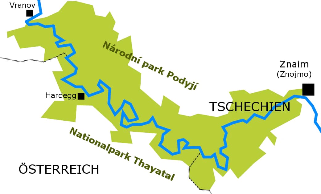
Thayatal National Park is best known for its spectacular breakthrough valley with steep forested slopes, its remarkable biodiversity that includes half of Austria's plant species within its small area, and its transboundary connection to Czech Podyjí National Park. The park protects one of Austria's most scenic river valleys and serves as a refuge for rare species including otters, black storks, white-tailed eagles, and recently returned species such as elk and wildcat. The town of Hardegg and Hardegg Castle sit within the park boundary, adding historical dimension to the natural landscape.

Thayatal National Park history and protected-area timeline

The establishment of Thayatal National Park followed a decade of conservation efforts driven by cross-border environmental concerns. In 1984, when plans emerged for a power plant on the Czech side of the Thaya River, citizen initiatives and the municipality of Hardegg successfully mobilized to prevent the project, recognizing the valley's ecological value. This grassroots opposition led to the first protected area designations in 1988 and 1991, when two sections along the Thaya were placed under nature protection by ordinance of the Lower Austrian state government. After the Czech Republic established Podyjí National Park in 1991, Austria moved to match this protection status on its side of the border. The formal decision came in 1992, and following feasibility studies and legal preparation, the state contract was signed in 1997 between federal ministers and the governor of Lower Austria. The national park was officially founded in 2000 based on the Lower Austrian National Park Act, which was drafted to meet IUCN Category II criteria.

Thayatal National Park landscape and geographic character

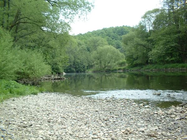
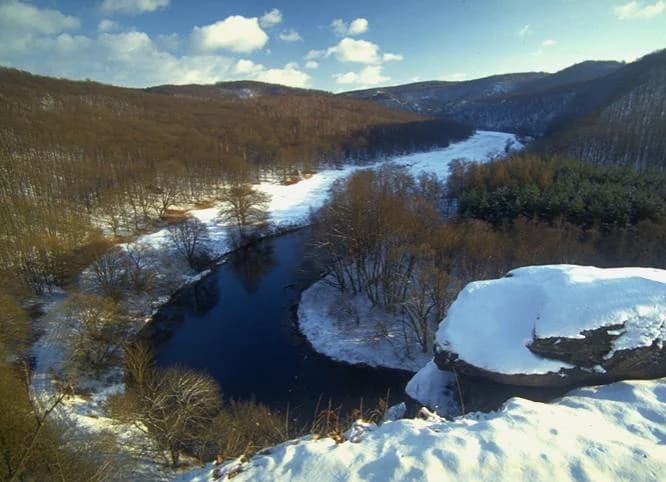
The landscape of Thayatal National Park is defined by the Thaya River's dramatic breakthrough valley, where the river has carved a deep gorge through ancient gneiss mountains. The valley's steep-sided walls are clothed in dense deciduous forest, creating a scenic environment that ranks among Austria's most beautiful river valleys. The highest point within the park is the Umlaufberg, a prominent gneiss peak around which the river wraps. Beyond the river corridor, the terrain consists of rocky slopes, forest-covered hillsides, and hidden valleys. The shape of the valley, combined with the orientation toward the sun and the chemical properties of the underlying rock, contributes to the park's ecological diversity. The built environment includes the town of Hardegg, Hardegg Castle, and the Kaja ruins, all situated within the park boundary.

Thayatal National Park ecosystems, habitats, and plant life

The ecological significance of Thayatal National Park far exceeds what its small size would suggest. The park is home to approximately half of all plant species found in Austria, a remarkable concentration that results from its position at the climatic boundary between two distinct ecological zones. The western part of the park and the shady northern slopes support beech forest communities dominated by red beech, with sycamore maple, yew, and mountain elm also present. The eastern portion and south-facing slopes feature oak and hornbeam forests that are notably dry and warm due to solar radiation. This habitat diversity supports a rich herb layer including species such as Turkish lily, daphne, wood sorrel, and the particularly rare white forest bird orchid. The intact river ecosystem of the Thaya provides essential habitat for aquatic species, while the dry grasslands and rocky sites add further ecological variety.

Thayatal National Park wildlife and species highlights

Thayatal National Park supports a notable array of rare wildlife species that have maintained or reclaimed populations within its boundaries. The intact river ecosystem provides crucial habitat for otters and dice snakes, while crested newts breed in the park's wetlands. White-tailed eagles winter in the area, utilizing the river and surrounding forests. The near-natural old-growth forests shelter hidden populations of black storks, Aesculapian snakes, and white-backed woodpeckers. The dry grasslands and rocky outcrops serve as important habitats for eastern green lizards, smooth snakes, eagle owls, and common ravens. Particularly significant is the return of species that had vanished from Austria following the opening of the Iron Curtain—elk and wildcat have both been spotted in the park, representing remarkable range expansions back into their former Austrian territories.

Thayatal National Park conservation status and protection priorities

Thayatal National Park holds significant conservation recognition beyond its national park status. The park is designated as an IUCN Category II protected area, meeting international standards for national park protection. Within its boundaries, 250 hectares of the core zone have been certified as WILDForest areas by the European Wilderness Society, recognizing their wilderness quality and ecological integrity. Additionally, approximately 2 kilometers of the Thaya River have been certified as a WILDRiver, acknowledging the river's natural state and ecological importance. The park's transboundary nature, sharing protection with Czech Podyjí National Park, enhances its conservation value by maintaining ecological connectivity across the international boundary. The park has also been designated as a Ramsar Wetland site, providing international recognition of its wetland conservation significance.

Thayatal National Park cultural meaning and human context

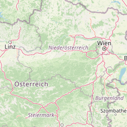
The cultural landscape of Thayatal National Park includes significant historical features embedded within its natural environment. The town of Hardegg sits at the heart of the park, with the medieval Hardegg Castle (Burg Hardegg) occupying a prominent position in the settlement. The Kaja ruins are also located within park boundaries, adding archaeological and historical dimension to the protected area. The park lies in the Waldviertel region of Lower Austria, an area with rich cultural heritage. The transboundary nature of the landscape reflects the shared history of the Austrian-Czech border region, and the Thaya bridge at Hardegg physically connects the two national park territories, allowing visitors to move between countries while exploring the continuous conservation landscape.

Top sights and standout views in Thayatal National Park

The most distinctive highlights of Thayatal National Park include its status as Austria's smallest national park with exceptional biodiversity, the dramatic Thaya breakthrough valley with steep forested slopes, and its seamless connection to Czech Podyjí National Park for transboundary exploration. The half of Austria's plant species found within its 13.3 km² represents an extraordinary concentration of botanical wealth. Visitors can experience the historic town of Hardegg and Hardegg Castle within the park, walk across the border into the Czech Republic, and explore certified WILDRiver and WILDForest areas. The recent return of species like elk and wildcat demonstrates the park's ecological vitality.

Best time to visit Thayatal National Park

Thayatal National Park can be visited year-round, with each season offering distinct character. The valley's position between continental and transitional climates means conditions can vary considerably by season. Spring brings flowering of the diverse plant species, while summer reveals the full lushness of the beech and oak forests. Autumn offers particularly striking visual interest as the deciduous foliage changes color. The winter season provides a quieter experience with bare trees offering different sightlines through the landscape. The transboundary access via the Thaya bridge at Hardegg operates throughout the year, allowing continuous connection to the Czech national park.

Park location guide

Geography guide, regional context, and park location map for Thayatal National Park

Thayatal National Park park geography, regions, and map view in Austria
Understand where Thayatal National Park sits in Austria through a broader geographic reading of the surrounding landscape, nearby location context, and its mapped position within the national park landscape.

How Thayatal National Park fits into Austria

Austria is a landlocked country in Central Europe, bordered by Germany, Czech Republic, Slovakia, Hungary, Slovenia, Italy, Switzerland, and Liechtenstein. The country is a federal semi-presessional republic composed of nine states, with Vienna as its capital and largest city. It has a population of approximately 9.1 million people.

Wider geography shaping Thayatal National Park in Austria

Austria is located in Central Europe, lying in the Eastern Alps. It is bordered by Germany and Czech Republic to the north, Slovakia to the northeast, Hungary to the east, Slovenia and Italy to the south, and Switzerland and Liechtenstein to the west.

Map view of Thayatal National Park

Use this park location map to pinpoint Thayatal National Park in Austria, understand its exact geographic position, and read its mapped placement within the surrounding landscape more clearly.

Pigeon | © OpenStreetMap contributors

Location context for Thayatal National Park

Lower Austria
Park atlas

Explore the regional geography and connected protected landscapes surrounding Thayatal National Park for deeper park comparison.

National Parks and Protected Areas Near Thayatal National Park: Expand Your Discovery
Browse a curated list of national parks and protected areas located in the vicinity of Thayatal National Park, including the neighboring Czech Podyjí National Park and other Central European conservation landscapes. This geographic overview allows users to compare different park characteristics, regional ecosystems, and transboundary protected areas, deepening their understanding of Central European park geography.
National parkSouth Moravian Region

Podyjí National Park: Explore Czech Republic's Intact River Canyon Ecosystem

Mapped Boundaries and Protected Landscape of South Moravia

Podyjí National Park, situated in the South Moravian Region, offers a profound look into one of Central Europe's most ecologically preserved river valleys. This national park is defined by its dramatic 220-meter deep Dyje River canyon, featuring rocky cliffs, stone seas, and a rich mosaic of forest and steppe habitats. MoriAtlas provides structured geographic information to analyze its unique landscape context, biodiversity, and role as a protected natural area within the Czech atlas.

Area
63 km²
Established
1991
Protected landscapeSouth Moravian Region

Moravian Karst Protected Landscape: Detailed Geographic and Cave System Atlas

Mapped protected boundaries and karst phenomena in the South Moravian Region.

Moravian Karst, designated a Protected Landscape Area, offers a profound look into complex karst geology within the South Moravian Region. This entry within MoriAtlas facilitates a structured discovery of its approximately 92 square kilometers, featuring an intricate network of over 1,100 caves and gorges. Users can explore the mapped extent of this geological treasure, understand its relationship with the surrounding regional geography, and appreciate the unique formations sculpted by underground water systems, including the iconic Macocha Abyss.

Area
92 km²
Scope
Terrestrial
Water
Minor water
National parkLower Austria

Danube-Auen National Park: Protected Floodplain Ecosystem and Regional Geography

Mapped boundaries and vital riparian landscape in Lower Austria.

Delve into the unique protected landscape of Danube-Auen National Park, a cornerstone of Central European riparian conservation. This page offers detailed insights into its mapped boundaries, the dynamic interplay of river channels, lowland forests, and wetlands, and its significant role within the geographic context of Lower Austria. Understand the atlas value of this protected area, ideal for discovering rich natural terrain and ecosystem context.

Area
93 km²
Established
1996
IUCN
II
Relief
Lowland
Watercolor illustration of a landscape with green hills, a body of water, and trees under a soft sky
National parkGyőr-Moson-Sopron

Fertő-Hanság National Park: Central European Wetland and Salt Lake Protected Area

Mapped Geographic Boundaries and Landscape Context

Fertő-Hanság National Park, situated in Győr-Moson-Sopron, Hungary, is a vital protected landscape renowned for its shallow salt lake and expansive marshlands. This page provides an atlas-focused discovery of its protected area, highlighting the unique interplay of reed beds and alkaline grasslands. Understand the park's geographic setting and its role as a significant wetland ecosystem for bird populations and specialized flora.

Area
235.88 km²
Established
1991
Relief
Lowland
Climate
Temperate
Watercolor painting showing a landscape with rolling terrain, water features, and distant mountains
National parkBurgenland

Neusiedler See-Seewinkel National Park: Protected Steppe Lake Landscape in Burgenland

Explore mapped wetland geography and birdwatching significance.

Neusiedler See-Seewinkel National Park showcases a rare steppe lake environment and extensive wetland habitats at the eastern edge of Austria, within the Burgenland region. This protected area is globally recognized for its exceptional avian diversity and the unique ecological mosaic formed by reed beds, salt marshes, and seasonal pools. Explore its mapped boundaries and distinctive Pannonian geography for a deep understanding of this vital European protected landscape.

Area
97 km²
Established
1993
IUCN
II
Relief
Lowland
Watercolor artwork depicting a landscape with green hills, distant mountains, and pastel sky
National parkLower Silesian Voivodeship

Stołowe Mountains National Park: Explore Poland's Sandstone Rock Cities and Protected Terrain

National Park in Lower Silesian Voivodeship: Geological Wonders.

Stołowe Mountains National Park is a protected national park in Poland celebrated for its unparalleled sandstone geological features. Within the Lower Silesian Voivodeship, the park showcases a dramatic landscape dominated by flat-topped rock plateaus, natural labyrinths, and vertical sandstone formations that create a visually stunning and geologically significant environment. Its protected status ensures the preservation of these unique landforms and the rare ecosystems, such as raised peat bogs, offering extensive opportunities for atlas exploration and understanding the region's distinct natural context.

Area
63.39 km²
Established
1993
IUCN
II
Visitors
1.3M annual
National parkUpper Austria

Kalkalpen National Park: Ancient Beech Forests and Karst Protected Landscape

Explore mapped boundaries and unique alpine terrain.

Kalkalpen National Park is a premier protected area in Upper Austria, celebrated for harboring Central Europe's largest remaining ancient beech forests and an extensive karst landscape. This designation underscores its critical role in preserving old-growth forest ecosystems and unique geological formations within the Northern Limestone Alps. Discover the mapped terrain and regional geography that define this significant natural reserve, offering a profound look into the continent's ecological history and protected natural heritage.

Area
208.25 km²
Established
1997
IUCN
II
Relief
Mountain
National parkStyria

Gesäuse National Park: Detailed Protected Landscape and Alpine Geography in Styria

Explore Austria's dramatic river gorge and rugged peaks.

Gesäuse National Park in Styria represents a significant alpine protected area, characterized by the striking Enns river gorge cutting through the Gesäuseberge. This national park offers a unique geographic context, showcasing steep limestone peaks, dramatic rock faces, and a rich hydrological network. Discover the mapped boundaries and protected landscape of one of Austria's most visually striking natural passages, ideal for detailed atlas exploration and understanding alpine conservation.

Area
110 km²
Established
2002
IUCN
II
Relief
Mountain

Common questions about visiting, size, designation, and location context for Thayatal National Park

Thayatal National Park FAQs for park facts, access, geography, and protected area context
Find quick answers about Thayatal National Park, including protected-area facts, park geography, trail and visitor context, and how the park fits into its surrounding country and regional landscape.
MoriAtlas Explorer

Continue Your Protected Areas Search Across the Global Atlas

Deepen your exploration by continuing the structured search for national parks and protected areas worldwide. Utilize the comprehensive filtering capabilities to compare different conservation landscapes and refine your understanding of global park geography. Discover more about the distribution and characteristics of protected natural areas.

Global natural geography